Showing 10613 items
matching sites
-
 Canterbury History Group
Ephemera - 2a Willow Grove Canterbury, [1997]
Real estate advertisement for the sale by auction of 2a Willow Grove Canterbury on 15 November [1997].ncludes a sketch of the exterior of the building and floor and site plans.canterbury, willow grove -
Canterbury History Group
Ephemera - 7 Cross Street, Canterbury, c 2009
Real estate advertisement for the sale of "Rosemont" 7 Cross Street Canterbury on 21 November [2009] Includes several coloured photogarphs and floor and site plans.canterbury, rosemont, cross street, victorian style, stained glass, cast iron work -
Canterbury History Group
Ephemera - 186 Prospect Hill Road Canterbury, 1/12/2002 12:00:00 AM
Real estate advertisement for the auction of 186 Prospect Hill Road Canterbury on 7 December 2002. Includes coloured exterior photographs and floor and site planscanterbury, prospect hill road, swimming pools, tennis courts -
 Wodonga & District Historical Society Inc
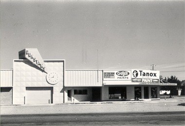
Photograph - Mann Collection Album - Dunstan's Corner, Wodonga, C. 1970s
These town photos are part of a collection donated by Elaine Mann. Elaine was married to David Mann, a successful Wodonga businessman and community leader who passed away in Wodonga in June 2012. David was a member of the Mann family who began their business in Wodonga in 1920. Elaine was a teacher in Wodonga for many years and an active member of the community. Arthur Dunstan Hardware Arthur Dunstan established mills at Red Bluff on the Mitta and a timber yard at Wodonga. He also built a sawmill at Glen Wills in 1931 which operated for about 16 years. A larger and more modern sawmill with drying kilns was erected at Eskdale in 1947. He was contracted to build Wodonga’s Municipal sale yards in 1935, followed by the Wangaratta sale yards. This created so many forward orders that he bought a large block of land on the corner of Beechworth and Tallangatta Roads and opened a timber mill and hardware store. The business stood on this corner for about 40 years. A large proportion of the company's timber output was processed at the Wodonga yards into flooring, weatherboards, mouldings etc. and practically the whole output was distributed locally and throughout the Riverina and eastern areas of New South Wales, and Canberra. At its peak Dunstan’s was one of the biggest sawmilling businesses in Victoria and in Wodonga employed 150 people and milled l6,000,000 super feet of timber annually. A super foot is a measurement for timber, equal to one foot square by one inch thick. Arthur Dunstan also built Tower Place in High Street. He died in Wodonga in 1963 and the business was continued on by his sons. Dunstan’s timber yards in Wodonga were sold to Ezerd Industries in 1987 with the retail section being bought by BBC Hardware.This photo collection is of significance as it documents how the businesses and buildings in Wodonga have evolved and contributed to community throughout the late 20th century. A. Dunstan & Sons Hardware was located at the roundabout on the corner of High Street and Thomas Mitchell Drive (Formerly Tallangatta Road). "Southside Terrace" now occupies this site.wodonga businesses, high st wodonga, dunstan's hardware wodonga -
 Wodonga & District Historical Society Inc
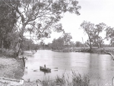
Album - Hume Reservoir Australia Album - The River Murray at the site of the dam 28th November, 1919, 1927
This set of photos is from a leather bound album bearing the inscription "HUME RESERVOIR AUSTRALIA" plus 'The Rt. Hon. L. C. M. S. Amery, P. C., M .P.' all inscribed in gold. It was presented to The Rt. Hon. L. C. M. S. Amery, P. C., M. P, Secretary of State for Dominion Affairs on the occasion of his visit to the Hume Reservoir on 2nd November 1927. This album is of local and national significance as it documents the planning and development of the Hume Reservoir up to 1927. It was the largest water reservoir in the British Empire. The album records the pioneering engineering work that went into its construction.DEPARTMENT OF PUBLIC WORKS, N.S.W. RIVER MURRAY WATERS SCHEME. HUME RESERVOIR. The River Murray at the site of the dam on 28th November 1919 looking upstream. hume reservoir australia, river murray waters scheme, hume weir diagrams, hume plan details -
 Lakes Entrance Regional Historical Society (operating as Lakes Entrance History Centre & Museum)
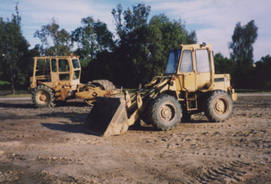
Photograph, Lakes Entrance Tidy Towns Committee, 1999
also second colour photograph ground cleared and levelled in preparation for skate park 1999Colour photograph bulldozers levelling the proposed site for the skate park, previously the southern roadway approach to the previous North Arm bridge. Lakes Entrance Victoriasporting facilities, construction -
Bendigo Historical Society Inc.
Document - DIAMOND HILL, GLASGOW GOLCONDA REEF GOLD MINE
BHS CollectionDescription of the heritage values of the Glasgow Golconda Reef Gold Mine sites. Information taken from 'On My doorstep' website ( no longer available, 10/2022)bendigo, mining, glasgow golconda -
 Lakes Entrance Regional Historical Society (operating as Lakes Entrance History Centre & Museum)
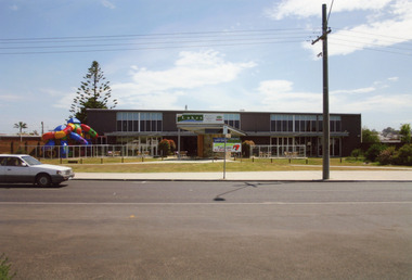
Photograph - Entertainment Centre, 2008
Date made August 2008Colour photograph of the Lakes Entrance Entertainment Centre, playground in front of building. This site was originally Carpenters Caravan Park situated on Esplanade. Lakes Entrance Victoriarecreation, resort, room display -
Kew Historical Society Inc
Archive (Sub-series) - Subject File, Fernhurst (Kew), 1973
Various partiesReference, Research, InformationSecondary Values (KHS Imposed Order)Subject file containing research related to George Wharton and his house Fernhurst, originally situated on the corner of Princess Street and Studley Park Road, but later subdivided. The house was in the 20th century converted into flats and later bought by the Catholic Church, who established St Paul’s School for the Blind on the site. The situation was complicated as the Church also bought the neighbouring Neama and Mandalay. Villa Maria and St Paul’s School currently occupy the site. Part of the site was later subdivided to create Elphinstone Court. The file contains photocopied extracts from histories and detailed research and correspondence between the School, the Kew Historical Society, the National Trust of Victoria, and the Historic Buildings Preservation Council relating to both Neama and Fernhurst. There is a reference in a letter from St Paul’s inviting the Society to collect artefacts from the site. There are no known current items in the collection relating to the collection of these. kew (vic) - history, victorian architects - george wharton, fernhurst (kew), st paul’s school for the blindkew (vic) - history, victorian architects - george wharton, fernhurst (kew), st paul’s school for the blind -
Federation University Historical Collection
Document, Graeme Tyrrell, Overview for the Development of Gardens Lydiard Street Campus, 1988, 01/12/1988
The report was prepared by Graeme Tyrrell, headgroundsman/Gardener at the Ballarat School of Mines (SMB) for Bob Feary, Manager of Facilities at SMB. The report was designed to present a broad cover of current plans for specific sites at the Lydiard Street campus.Seven page report on the development of the Ballarat School of Mines Gardens, including the Motor Mechanics Portable, Hickman Street (now demolished); Recreation Building (now demolished), E.P.U.Y Building, Hickman Street, vacant block behind creche (now site of UBTec building); Creche, Grant Street (now demolished); Former Courthouse building, Grant Street terrace, Brick Court yard, conifer beds lining Lydiard Street, Herb Garden above M.B. John Building, Terrraced area above Ballarat School of Mines Botanical Garden (referred to as Von Mueller garden). The report includes a campus plan. The report is copied onto white paper and is stapled at the top left corner. ballarat school of mines botanical gardens, ballarat school of mines, bob feary, graeme tyrrell, gardens, ballarat school of mines campus, smb campus -
 Orbost & District Historical Society
map/poster, Victorian Government Printer, 22.4.1926
The Department of Crown Lands and Survey was originally established in 1857 as part of the Board of Land and Works. In 1964 it ceased to be controlled by the Board. The Department functioned for almost twenty more years before being combined with other Ministries to form the Department of Conservation, Forests and Land. It was responsible for the management of the State's Crown land and pastoral estates. This map was used by Don Mehlert after 1928. The VERMIN AND NOXIOUS WEEDS ACT 1928 was an Act to consolidate the Law relating relating to Vermin and Noxious Weeds. E. J. E. G. Pemberton who published this poster was Superintendent of Field Staff, Dept. of Lands and Survey. This map and posters are significant records of early settlement history in Murrangower, between Cabbage Tree and Orbost,A paper map of Murrangower showing settlement subdivisions. This is glued onto the back of four overlapping cloth poster of "Notices of Vermin Destruction". All print is black."DON MEHLERT" in black pen. Pike's block shaded in blue. School site marked in blue pencil. on poster "MURRANGOWAR" along side.map-murrangower poster-vermin-and-noxious-weeds murrangower-settlement -
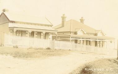
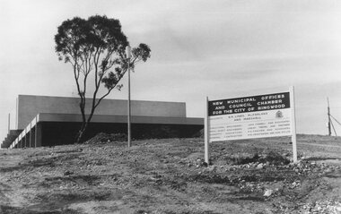 Ringwood and District Historical Society
Photograph, Maroondah Highway East, Ringwood- 1969. New Civic Centre being built in Braeside Ave
Black and white photographSign on construction site reads: New Municipal Offices and Council Chamber for the City of Ringwood. Also shows names of Architects and other Contractors. -
 Warrnambool and District Historical Society Inc.
Documents, WCC Proposed turntable site railway station, 1968; 1989
These two plans are copies and show drawings for a proposed turntable at the Warrnambool Railway Station and railway crossings at Gilles Street in the Liebig Street precinct. The Warrnambool Railway was opened in 1890 and the Warrnambool Railway Station building was erected a few years later. These plans, being copies, are of minor interest as they show plans of some projects in the Warrnambool Railway Station precinct in the latter half of the 20th century.These are two sheets of cream-coloured paper with plans (copies of original) drawn up in black ink. The drawings are fading somewhat and are faint in places. One sheet (.2) has a piece missing from the top left hand corner. .1 ‘Locality Plan of Rail Crossings Liebig St. & Gillies (sic) St.’ .2 ‘Proposed Turntable Site Warrnambool Railway Station’ plans, warrnambool railway, warrnambool rail turntable -
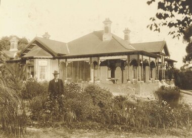 Ringwood and District Historical Society
Photograph, Captain Miles and his home. 1920
Black and white photograph of man standing in garden in front of house.Typed below photographs: Captain Miles and his home. Site is now Church of England 1935. Miles died in 1944. "Glamorgan" (1920). -
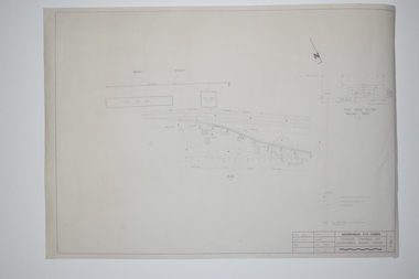
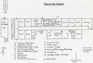 Ringwood and District Historical Society
Plan - Plans - Building, Southwood Primary School, Ringwood, Collection of building plans, site plans, floor plans 1969-1991
folder of papers plansSouthwood PS - Site Plan and floor plans including A.D. Alexander Hall. Permanent File. To be archived at P.R.O when no longer required. -
 Ringwood and District Historical Society
Photograph, Station Street Ringwood c.1910-1913 and later photograph of Dr Langley's then former residence in 1963
Two photographs taken approx. 50 years apart at Station Street looking towards Dr. Langley's residence on the right in the early photograph at the Kendall Street corner c.1910-1913. (Ref. p.176 Ringwood - Place of Many Eagles). The later photograph shows Dr Langley's then former residence in 1963.Typed below photograph, "Station St. cnr. Kendall St. Dr. Langleys residence on right, later became the site of Christian Scientists". -
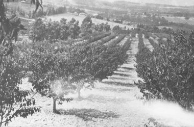 Ringwood and District Historical Society
Photograph, McKinley Orchard. Site of Norwood High School. c1920
Black and white photograph (3 copies)Written on back of one photograph- "McKinley Orchard. Site of Norwood High School. Taken from back of 18-20 Wonga Rd."agriculture -
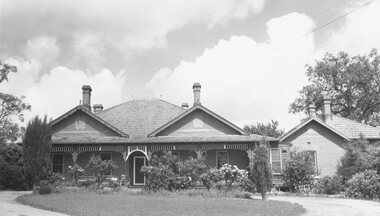 Ringwood and District Historical Society
Photograph, Pines Hospital 1965
Black and white photograph of brick building.Typed below photograph, "The old 'Pines' hospital in Adelaide Street. 1965. Now Eastland site. Many older Ringwood residents born there." -
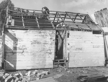 Ringwood and District Historical Society
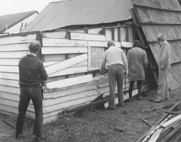
Photograph, Dismantling Ringwood miners cottage in 1975
Ringwood Miners Cottage (1873) during disassembly, April 1975. Formerly at 367 Maroondah Highway almost opposite Civic Centre site. -
 Ringwood and District Historical Society
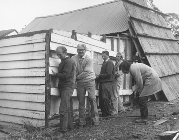
Photograph, Dismantling Ringwood miners cottage in 1975
Ringwood Miners Cottage (1873) during disassembly, April 1975. Formerly at 367 Maroondah Highway almost opposite Civic Centre site. -
 Ringwood and District Historical Society
Photograph, Dismantling Ringwood miners cottage in 1975
Ringwood Miners Cottage (1873) during disassembly, April 1975. Formerly at 367 Maroondah Highway almost opposite Civic Centre site. -
 Ringwood and District Historical Society
Photograph, Old Ringwood Timber & Hardware Co. site looking towards New Street Ringwood, prior to new development late 1980
Written on back of photograph, 'Late '80. Old RWT & H Co. site looking towards New St. prior to new development.' -
 St Kilda Historical Society
Photograph, c.1964
Typical example of replacement from mansions to flats. Three storey walk ups, by three buildings. In the modern style. Brick.black and white photograph, mounted in good condition.Flats Barkly Street, site of former St Margarets, 56 Barkly Street, taken in 1964. Old house demolished and flats erected.' -
 St Kilda Historical Society
Postcard, Brighton Rd (south west)
Photo shows two adults and four children with croquet sticks in hand in front of building black and white photograph, unmounted, copy, good conditionOn back: Brighton Road, w side Built for Emil Thoneman, Merchant. Demolished approx 1960. Flats now on the site in Wimbledon Avenue -
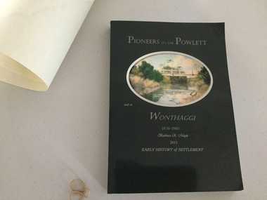 Wonthaggi & District Historical Society
Book and Map, Barbara Moyle, Pioneers on tthe Powlett and at Wonthaggi 1878-1910, 2015
Book - families social histories, maps, photograps Map - block numbers town names physical / geographical featuresFarming and social history of pioneers of the Powlett River are prior to the establishment of the State Coal Mine at Wonthaggi. Significant land marks, buildings and photographs are included. Dark green cover with oval artists impression of Powlett river and bridge Associated map which covers the parishes plus key places of interestlPioneers on the Powlett and at Wonthaggi 1878-1910 Barbara R Moyle 2015 Early History of Settlement Map - Parish names, significant sitesfarming, pioneers of wonthaggi and district, wonthaggi families -
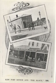 Kew Historical Society Inc
Print, FGA Barnard, Kew Post Office and 'The Block' 1880
This work forms part of the collection assembled by the historian Dorothy Rogers, that was donated to the Kew Historical Society by her son John Rogers in 2015. The manuscripts, photographs, maps, and documents were sourced by her from both family and local collections or produced as references for her print publications. Many were directly used by Rogers in writing ‘Lovely Old Homes of Kew’ (1961) and 'A History of Kew' (1973), or the numerous articles on local history that she produced for suburban newspapers. Most of the photographs in the collection include detailed annotations in her hand.The Rogers Collection provides a comprehensive insight into the working habits of a historian in the 1960s and 1970s. Together it forms the largest privately-donated collection within the archives of the Kew Historical Society.A print made for Dorothy Rogers of a book plate originally published in F.G.A. Barnards 'Jubilee History of Kew' (1910) showing a view of Barnard's pharmacy and post office on the corner of High Street and Cotham Road, where the Kew Post Office was to be built in 1888."Barnard's Post Office on present P.O. corner prior to 1880. 1st P.O. was in Houwiesons Shop. This is the site of The Block . See other photo"francis barnard, dorothy rogers, kew post office -
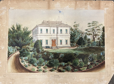 Kew Historical Society Inc
Work on paper, Madford: the property of A.S. King Esq, c.1875
The Victorian-era mansion Madford in Wellington Street had several incarnations before it was finally demolished. While the precise details of its original construction have not been discovered, we know that it was originally named Elm Lodge, and that the property was offered for sale in 1863 by Thomas Mitchell, of the firm Mitchell & Bonneau, wholesale ironmongers and merchants. The house was sold in about 1873 to William Siddeley (1827-1905), who was described on the occasion of his death as ‘the father of Australian shipping’. The next owner was Arthur Septimus King (1827- 99), who renamed the house Madford after his purchase of the property in 1875. It was A.S. King for whom this artwork was completed. Following King’s death in 1899, portions of the property were sold, including to the Borough of Kew in 1905, to form the Alexandra Gardens. Then, in 1920, the house and its remaining lands were sold to the Catholic Church who opened St Anthony’s Home for Children on the site in 1922. That building was promptly demolished, and the site redeveloped circa 1976.Gift of James Pearson, 2022This fine perspective drawing of the architectural elements of Madford [formerly Elm Lodge, later St Anthony's Home for Babies] is contrasted with the freer addition in watercolour of the layout and plants of the garden facing Wellington Street. The view selected is the south-facing main facade and the west facing side. After A.S. King purchased the house in 1875, it was extended with new wings at the rear to accommodate his large family. There is no indication of these extensions in the painting so its creation must predate the renovations, and probably depicts the original building on the site."MADFORD / The Property of A. S. KING Esq"elm lodge, madford, st anthony's home for babies, houses -- wellington street -- kew (vic.), thomas mitchell, william siddeley, arthur septimus king -
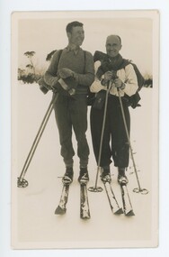 Falls Creek Historical Society
Photograph - King's Birthday Weekend 1936 on the High Plains
MEYER COLLECTION - FALLS CREEK PHOTOS In 1947 a determined group of like-minded State Electricity Commission (SEC) staff including Ray Meyer, the chief surveyor of the Kiewa Hydro-Electric Scheme, had a common interest that revolved around the skiing potential of the snow-covered high plains which included what is now the resort of Falls Creek. The six SEC employees, Toni St Elmo, Ray Meyer, Jack Minogue, Lloyd Dunn, Adrian Ruffenacht and Dave Gibson (together with their families) banded together to secretly build a 'hut' that was the first ski lodge at Falls Creek. Using a road built in 1930s to gain access to Falls Creek, their hut project was carried out in secret as efforts by other skiers were blocked by H.H.C. Williams – the engineer in charge of the Hydro Scheme. In 1946 Ray Meyer made a trip to the Lands Office in Melbourne. He came away with a 99-year lease on three acres that was ideally suited for a hut designed by Lloyd Dunn. Adrian Ruffenacht (Design Engineer for the KHS) had suggested where the group should build because of easy access to a spring for water. Much of the building material required was scavenged from derelict huts on the high plains. Due to the need for secrecy, the determined group worked on the hut in the evenings and weekends to avoid detection. During the building period the group had met at Echidna Rock (now known as Eagle Rock) where Skippy St Elmo announced, "This is my favourite ‘Skyline’.” And so the first lodge in the area at Falls Creek Ski Resort came into existence. With the development of the International Poma in the 1970s, the Skyline Lodge, which was sited between the ski-lift’s pole one and pole two, was demolished. However, the legacy of Ray Meyer, Toni St Elmo, Jack Minogue, Lloyd Dunn, Adrian Ruffenacht and Dave Gibson and Skyline lives on in the vibrant atmosphere of Falls Creek Resort. The MEYER COLLECTION documents developments on the Kiewa Hydro Scheme and their life at Falls Creek from the mid 1930s to 1960s.This image is significant because it depicts aspects of the life of a pioneering family of Falls Creek and the founders of "Skyline", the first lodge at Falls Creek.Three images taken on the King's Birthday weekend in 1936. Kelly's Hut and stockyards were built by Patrick J Kelly in 1901. In 1956 the hut was burnt down and replaced with a State Electricity Commission (SEC) hut moved from a nearby site. falls creek, bogong high plains, kelly's hut, kelly's stockyard, tom fitzgerald, perc semmens -
![Booklet: Bundoora: a site for Preston Institute of Technology [1968]](/media/collectors/4fac93a2023fd71f703efeec/items/519c5b782162ef13f0d2bf7b/item-media/519c5e5d2162ef13f0d2c4bd/item-fit-380x285.jpg) NMIT (Northern Melbourne Institute of TAFE)
NMIT (Northern Melbourne Institute of TAFE)Booklet: Bundoora: a site for Preston Institute of Technology [1968]
Booklet of 15 pages. On cover 'Bundoora: a site for Preston Institute of Technology'. Page 14 refers to this being a deputation from Preston City Council and Council of PIT to Victorian Premier applying for use of Bundoora Police Paddock for PIT. It is undated but probably late 1960s. Also a loose aerial photo of a site which is a closeup of a section of the photo on the cover of the booklet and this photo is dated 1968 preston institute of technology, preston technical college, bundoora campus, nmit -
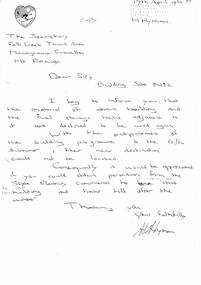 Falls Creek Historical Society
Letter - Hand-Written - Building Site No.2, 17.04.1963
Bob (Herman) Hymans (a former member of the Royal Netherlands Navy) was born in Bloemendaal, Holland on 30th September 1922. During World War II he fought against the Japanese in the Dutch East Indies (now Indonesia) and was imprisoned in Changi and on the Burma Railway. After gaining qualifications as a Ski Instructor, Bob arrived in Falls Creek in July 1950. Working as an Instructor and Supervisor at Bogong Lodge, Bob decided his future was in accommodation. He was successful in negotiating an indenture for land from the State Electricity Commission (SEC). It took Bob two years to build his Grand Coeur Chalet but, tragically, it was burned down in August 1961. Bob also built the first Chairlift in Australia. This was a single chairlift and the structure was built from wooden electricity poles. He was constantly full of new ideas and proposals for the village. Bob Hymans die on 7th July 2007. This Collection of documents and letters tells the story of Bob's endeavours to develop Falls Creek into the ski village it is today.This letter is significant because it reflects the relationship between Bob Hymans and the Management Committee.In this letter to the Falls Creek Tourist Area Management Committee, Mr Hymans' indicates that he intends to use materials currently stored in the building on Site 2. As the building program had been delayed by the SEC until the summer of 63/64, he does not know where their new destination would be. Consequently Mr Hymans was requesting permission to leave the materials at Site No 2. over the winter.falls creek tourist area management committee, bob hymans, falls creek administration