Showing 1838 items matching "1888"
-
 Kew Historical Society Inc
Slide - 'Reno', St John 's Parade, 1977
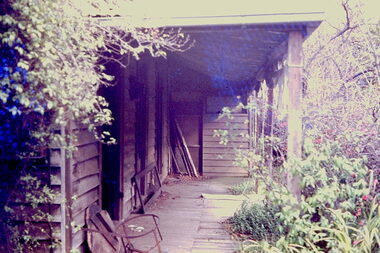
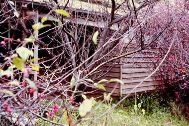
‘Reno’, stood on the east side of St John’s Parade. Its earliest recorded owner was the architect Samuel Cocking who lived there from c.1865 until his death in 1888. The original landholding was bordered by Cotham Road, Glenferrie Road, Wellington Street, and Charles Street. The southern portion of this land included a fine orchard, with many imported trees. The old summer house, at first in the orchard, was later removed to the house garden. The MMBW Detail Plan No.1576 (1904) shows the remaining portion of the original land holding, including a semi-circular pathway at the front, and garden features such as an aviary, a fountain and grotto, and a fernery. The garden including rare plants supplied by Baron Von Mueller, surrounds the cottage in a tangled frenzy. Despite a ‘local significance’ classification by the National Trust, the house was demolished in 1977.Rare photograph of an historically important weatherboard cottage in St John's Parade.Colour positive transparency (slide) of the verandah of 'Reno' in St John's Parade, Kew (demolished 1977). historic houses -- kew (vic.), reno -- st john's parade -- kew (vic.) -
 Kew Historical Society Inc
Slide - 'Reno', St John 's Parade, 1977
‘Reno’, stood on the east side of St John’s Parade. Its earliest recorded owner was the architect Samuel Cocking who lived there from c.1865 until his death in 1888. The original landholding was bordered by Cotham Road, Glenferrie Road, Wellington Street, and Charles Street. The southern portion of this land included a fine orchard, with many imported trees. The old summer house, at first in the orchard, was later removed to the house garden. The MMBW Detail Plan No.1576 (1904) shows the remaining portion of the original land holding, including a semi-circular pathway at the front, and garden features such as an aviary, a fountain and grotto, and a fernery. The garden including rare plants supplied by Baron Von Mueller, surrounds the cottage in a tangled frenzy. Despite a ‘local significance’ classification by the National Trust, the house was demolished in 1977.Rare photograph of an historically important weatherboard cottage in St John's Parade.Colour positive transparency (slide) of the a doorway of 'Reno' in St John's Parade, Kew (demolished 1977). historic houses -- kew (vic.), reno -- st john's parade -- kew (vic.) -
 Kew Historical Society Inc
Slide - 'Reno', St John 's Parade, 1977
‘Reno’, stood on the east side of St John’s Parade. Its earliest recorded owner was the architect Samuel Cocking who lived there from c.1865 until his death in 1888. The original landholding was bordered by Cotham Road, Glenferrie Road, Wellington Street, and Charles Street. The southern portion of this land included a fine orchard, with many imported trees. The old summer house, at first in the orchard, was later removed to the house garden. The MMBW Detail Plan No.1576 (1904) shows the remaining portion of the original land holding, including a semi-circular pathway at the front, and garden features such as an aviary, a fountain and grotto, and a fernery. The garden including rare plants supplied by Baron Von Mueller, surrounds the cottage in a tangled frenzy. Despite a ‘local significance’ classification by the National Trust, the house was demolished in 1977.Rare photograph of an historically important weatherboard cottage in St John's Parade.Colour positive transparency (slide) of the verandah of 'Reno' in St John's Parade, Kew (demolished 1977). historic houses -- kew (vic.), reno -- st john's parade -- kew (vic.) -
 Kew Historical Society Inc
Slide - Grotto of 'Reno', St John 's Parade, 1977
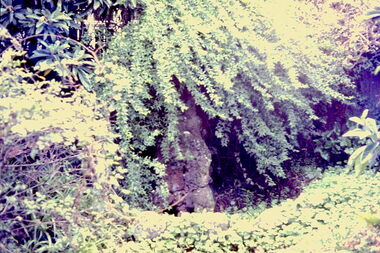
‘Reno’, stood on the east side of St John’s Parade. Its earliest recorded owner was the architect Samuel Cocking who lived there from c.1865 until his death in 1888. The original landholding was bordered by Cotham Road, Glenferrie Road, Wellington Street, and Charles Street. The southern portion of this land included a fine orchard, with many imported trees. The old summer house, at first in the orchard, was later removed to the house garden. The MMBW Detail Plan No.1576 (1904) shows the remaining portion of the original land holding, including a semi-circular pathway at the front, and garden features such as an aviary, a fountain and grotto, and a fernery. The garden including rare plants supplied by Baron Von Mueller, surrounds the cottage in a tangled frenzy. Despite a ‘local significance’ classification by the National Trust, the house was demolished in 1977.Rare photograph of an historically important weatherboard cottage in St John's Parade.Colour positive transparency (slide) of the grotto in the garden of 'Reno' in St John's Parade, Kew (demolished 1977). historic houses -- kew (vic.), reno -- st john's parade -- kew (vic.) -
 Kew Historical Society Inc
Slide - Former Summerhouse in the Garden of 'Reno', St John 's Parade, 1977
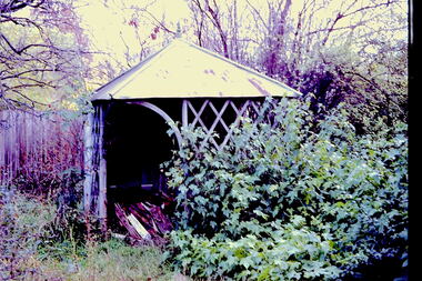
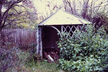
‘Reno’, stood on the east side of St John’s Parade. Its earliest recorded owner was the architect Samuel Cocking who lived there from c.1865 until his death in 1888. The original landholding was bordered by Cotham Road, Glenferrie Road, Wellington Street, and Charles Street. The southern portion of this land included a fine orchard, with many imported trees. The old summer house, at first in the orchard, was later removed to the house garden. The MMBW Detail Plan No.1576 (1904) shows the remaining portion of the original land holding, including a semi-circular pathway at the front, and garden features such as an aviary, a fountain and grotto, and a fernery. The garden including rare plants supplied by Baron Von Mueller, surrounds the cottage in a tangled frenzy. Despite a ‘local significance’ classification by the National Trust, the house was demolished in 1977.Rare photograph of an historically important weatherboard cottage in St John's Parade.Colour positive transparency (slide) of the former summerhouse in the garden of 'Reno' in St John's Parade, Kew (demolished 1977). historic houses -- kew (vic.), reno -- st john's parade -- kew (vic.) -
 Kew Historical Society Inc
Slide - 'Reno', St John 's Parade, 1977
‘Reno’, stood on the east side of St John’s Parade. Its earliest recorded owner was the architect Samuel Cocking who lived there from c.1865 until his death in 1888. The original landholding was bordered by Cotham Road, Glenferrie Road, Wellington Street, and Charles Street. The southern portion of this land included a fine orchard, with many imported trees. The old summer house, at first in the orchard, was later removed to the house garden. The MMBW Detail Plan No.1576 (1904) shows the remaining portion of the original land holding, including a semi-circular pathway at the front, and garden features such as an aviary, a fountain and grotto, and a fernery. The garden including rare plants supplied by Baron Von Mueller, surrounds the cottage in a tangled frenzy. Despite a ‘local significance’ classification by the National Trust, the house was demolished in 1977.Rare photograph of an historically important weatherboard cottage in St John's Parade.Colour positive transparency (slide) of the garden of 'Reno' in St John's Parade, Kew (demolished 1977). historic houses -- kew (vic.), reno -- st john's parade -- kew (vic.) -
 Kew Historical Society Inc
Slide - Former Summerhouse in the Garden of 'Reno', St John 's Parade, 1977
‘Reno’, stood on the east side of St John’s Parade. Its earliest recorded owner was the architect Samuel Cocking who lived there from c.1865 until his death in 1888. The original landholding was bordered by Cotham Road, Glenferrie Road, Wellington Street, and Charles Street. The southern portion of this land included a fine orchard, with many imported trees. The old summer house, at first in the orchard, was later removed to the house garden. The MMBW Detail Plan No.1576 (1904) shows the remaining portion of the original land holding, including a semi-circular pathway at the front, and garden features such as an aviary, a fountain and grotto, and a fernery. The garden including rare plants supplied by Baron Von Mueller, surrounds the cottage in a tangled frenzy. Despite a ‘local significance’ classification by the National Trust, the house was demolished in 1977.Rare photograph of an historically important weatherboard cottage in St John's Parade.Colour positive transparency (slide) of the former summerhouse in the garden of 'Reno' in St John's Parade, Kew (demolished 1977). historic houses -- kew (vic.), reno -- st john's parade -- kew (vic.) -
 Kew Historical Society Inc
Photograph - 'Reno', 10 St John's Parade, John T Collins, 1977
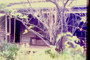
‘Reno’, stood on the east side of St John’s Parade. Its earliest recorded owner was the architect Samuel Cocking who lived there from c.1865 until his death in 1888. The original landholding was bordered by Cotham Road, Glenferrie Road, Wellington Street, and Charles Street. The southern portion of this land included a fine orchard, with many imported trees. The old summer house, at first in the orchard, was later removed to the house garden. The MMBW Detail Plan No.1576 (1904) shows the remaining portion of the original land holding, including a semi-circular pathway at the front, and garden features such as an aviary, a fountain and grotto, and a fernery. The garden including rare plants supplied by Baron Von Mueller, surrounds the cottage in a tangled frenzy. Despite a ‘local significance’ classification by the National Trust, the house was demolished in 1977.Partial view, north side of the weatherboard cottage in St John's Parade, Kew, known as 'Reno' (demolished 1977). Architectural elements revealed in this photo by John T Collins include: two wing, hip roof construction; external buildings at angles to main wing; corrugated iron roofing [over shingles]; brick chimney external to building; unvarnished/unpainted external weatherboards. General dilapidated condition. "Kew 'Reno' 10 St Johns Pde / John Collins, 11 Anderson Road, Hawthorn East, 3123, Film 35B Exposure 27"reno - st john's parade -- kew (vic.), john t collins -
 Kew Historical Society Inc
Photograph - 'Reno', 10 St John's Parade, John T Collins, 1977
‘Reno’, stood on the east side of St John’s Parade. Its earliest recorded owner was the architect Samuel Cocking who lived there from c.1865 until his death in 1888. The original landholding was bordered by Cotham Road, Glenferrie Road, Wellington Street, and Charles Street. The southern portion of this land included a fine orchard, with many imported trees. The old summer house, at first in the orchard, was later removed to the house garden. The MMBW Detail Plan No.1576 (1904) shows the remaining portion of the original land holding, including a semi-circular pathway at the front, and garden features such as an aviary, a fountain and grotto, and a fernery. The garden including rare plants supplied by Baron Von Mueller, surrounds the cottage in a tangled frenzy. Despite a ‘local significance’ classification by the National Trust, the house was demolished in 1977.Partial view, side of the weatherboard cottage in St John's Parade, Kew, known as 'Reno' (demolished 1977). Architectural elements revealed in this photo by John T Collins include: hip roof construction; corrugated iron roofing [over shingles]; unvarnished/unpainted external weatherboards; Externally opening 1860s-style casement window. General dilapidated condition. "Kew 'Reno' 10 St Johns Pde / John Collins, 11 Anderson Road, Hawthorn East, 3123, Film 35B Exposure 26"reno - st john's parade -- kew (vic.), john t collins -
 Kew Historical Society Inc
Photograph - 'Reno', 10 St John's Parade, John T Collins, 1977
‘Reno’, stood on the east side of St John’s Parade. Its earliest recorded owner was the architect Samuel Cocking who lived there from c.1865 until his death in 1888. The original landholding was bordered by Cotham Road, Glenferrie Road, Wellington Street, and Charles Street. The southern portion of this land included a fine orchard, with many imported trees. The old summer house, at first in the orchard, was later removed to the house garden. The MMBW Detail Plan No.1576 (1904) shows the remaining portion of the original land holding, including a semi-circular pathway at the front, and garden features such as an aviary, a fountain and grotto, and a fernery. The garden including rare plants supplied by Baron Von Mueller, surrounds the cottage in a tangled frenzy. Despite a ‘local significance’ classification by the National Trust, the house was demolished in 1977.Side of the original, relocated summer house of 'Reno' at 10 St John's Parade, Kew, (demolished 1977). Architectural elements revealed in this photo by John T Collins include: four-sided construction; trellis and weatherboard walls; corrugated iron roofing. Re-use as woodshed. General dilapidated condition. "Kew 'Reno' 10 St Johns Pde / John Collins, 11 Anderson Road, Hawthorn East, 3123, Film 35B Exposure 24"reno - st john's parade -- kew (vic.), john t collins -
 Surrey Hills Historical Society Collection
Photograph, 'Montalto', 84 Union Road, Surrey Hills (demolished)
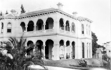
The mansion was built in 1888. The first occupant was Charles Brook Longbottom (independent means). In c1910 he moved to 92 Union Road. Anthony G Connell followed and then Dr John Box J P. (1863-1934); he was a surgeon at Williamstown Hospital and honorary surgeon at the Eye and Ear Hospital. John and his first wife Jessie Powell Mitchell (1872-1913) had a daughter who died in infancy, then 4 sons. Henry Powell Box became a solicitor; John Eric Mitchell Box became a chemist; Noel Edward Hamilton Box became a surgeon and and William Mitchell Box also became a doctor. John Box married Eleanor Beatrice Grist in 1917. Montalto was sold after her death, demolished and the land subdivided as Sythney Court.Black and white photo of a 2 storey Italianate mansion with arched verandas on 2 sides. There is palm tree on the near side of the driveway and outhouses in the background.SH519 in pencil on the rear.montalto, italianate style, dr john box, jessie powell box, jessie powell mitchell, eleanor beatric grist, eleanor beatric box, william mitchell box, henry powell box, noel edward hamilton box, john eric mitchell box -
 Bacchus Marsh & District Historical Society
Map - Land Sales Plan, Broadlands Estate, Bacchus Marsh, 1916
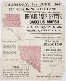
This land sales map was produced by real estate agents for an auction of part of a property near Bacchus Marsh known as the Broadlands Estate. 132 acres of irrigated land in 11 separate lots was to be auctioned on the 8th of June 1916. On the 27 May 1916, nine of the 11 eleven lots were withdrawn from sale. The reason stated was due to "road and severance difficulties", according to a notice in the Bacchus Marsh Express newspaper on 27 May, 1916, page.2. When the sale took place on 8th June the two lots were passed in but the local newspaper reported they were expected to be sold privately, see Express, 17 June, 1916, page. 2. The Broadlands Estate was owned by the Miller family whose father Henry Miller, 1809-1888, was a politician and an immensely wealthy financier in Victoria.A typical example of a land sale map of this era. The Broadlands Estate was just over 2,000 acres at its its peak size and was a significant holding of land in the Bacchus Marsh district. Paper printed land sales mapbroadlands estate bacchus marsh, land sales bacchus marsh, farms bacchus marsh, henry miller 1809-1888 -
 Wodonga & District Historical Society Inc
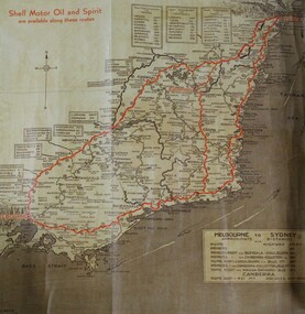
Map - Hamilton-Smith Collection Highway Map c. mid 1900s
The Hamilton-Smith collection was donated by the children of Grace Mary Hamilton-Smith nee Ellwood (1911-2004) and William John (Jack) Hamilton-Smith (1909-1984) who settled in Wodonga in the 1940s. The Ellwood family had lived in north-east Victoria since the late 1800s. Grace’s mother, Rosina Ellwood nee Smale, was the first teacher at Baranduda in 1888, and a foundation member of the C.W.A. Rosina and her husband Mark retired to Wodonga in 1934. Grace and John married at St. David’s Church, Albury in 1941. John was a grazier, and actively involved in Agricultural Societies. The collection contains significant items which reflect the local history of Wodonga, including handmade needlework, books, photographs, a wedding dress, maps, and material relating to the world wars.This item has well documented provenance and a known owner. It forms part of a significant and representative historical collection which reflects the local history of Wodonga. It contributes to our understanding of social life in mid-twentieth century Wodonga, as well as providing interpretative capacity for themes including local history and social history.A brown and tan highway map with red road markings showing the south east of Australia from Melbourne to Sydney map, highway, wodonga, melbourne, sydney, travel, hamilton-smith, hamilton-smith collection, driving, drive, car, road -
 Bendigo Historical Society Inc.
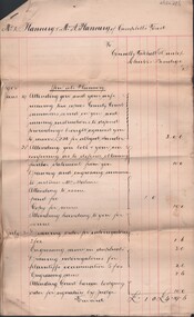
Document - CONNELLY, TATCHELL, DUNLOP COLLECTION: LEGAL PAPERS, 1890 - 1902
Document. Various legal papers. 1 -1894 - Feeham Jas. List of work and costs. 2 - 1893 - Delves H. List of work and costs. 3 - 1889 - Barber Alf. List of work and costs. 4 - 1893 - Mendell & Henderson. List of work and costs. 5 - 1892 - Holland Michael. List of work and costs. 6 - 1890 - Hay Adam. List of work and costs. 7 - 1889 - Hasker J. Costs. 8 - 1888 - New Spencer Street Syndicate. List of costs. 9 - 1894 - Schroder Mrs P with Hawkins Mr C H. Agreement of Tenancy. 10 - 1902 - Flannery Mr D & Flannery Mrs A of Campbell's Forest. Costs incurred. 11 - 189? Rathjen Mr H to Bockholt Mr W H. Draft copy lease. 12 - 1890 - Middleton J (T/1?) Costs.cottage, miners, connelly, tatchell & dunlop, feeham jas, delves h, barber alf, mendell & henderson, holland michael, hay adam, hasker j, new spencer street syndicate, schroder mrs p, hawkins mr c h, flannery d, flannery mrs a, rathjen h, bockholt w h, middleton j -
 Kew Historical Society Inc
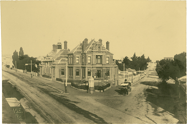
Photograph, J F C Farquhar, The Post Office, 1891
At the beginning of the 1890s, the Kew businessman and Town Councillor, Henry Kellett, commissioned J.F.C. Farquhar to photograph scenes of Kew. These scenes included panoramas as well as pastoral scenes. The resulting set of twelve photographs was assembled in an album, Kew Where We Live, from which customers could select images for purchase.The preamble to the album describes that the photographs used the ‘argentic bromide’ process, now more commonly known as the gelatine silver process. This form of dry plate photography allowed for the negatives to be kept for weeks before processing, hence its value in landscape photography. The resulting images were considered to be finely grained and everlasting. Evidence of the success of Henry Kellett’s venture can be seen today, in that some of the photographs are held in national collections.It is believed that the Kew Historical Society’s copy of the Kellett album is unique and that the photographs in the book were the first copies taken from the original plates. It is the first and most important series of images produced about Kew. The individual images have proved essential in identifying buildings and places of heritage value in the district.A panoramic photograph of the junction of High Street and Cotham Road. The photographer centres the point-of-view on the Kew Post Office and adjacent Court House. These were designed in the Queen Anne style by the Public Works Department's architect J Harvey and completed in 1888. The complex is important because it demonstrates a departure from the contemporaneously favoured High Victorian Classical to the Queen Anne style in the design of civic buildings. The earlier Jubilee Fountain in front of the Post Office was erected by the Kew Borough Council to commemorate the Golden Jubilee of Queen Victoria in 1887. It was created to a design of the architects Reed, Henderson and Smart. The fountain was later relocated to the Alexandra Gardens to make way for the Kew War Memorial. The tram tracks in High Street were used by the horse tram, which ran from the Victoria Street Bridge to the Boroondara General Cemetery. The tram was replaced by an electrified service in 1915.The Post Officekew post office, kew illustrated, kew where we live, photographic books, henry kellett -
 Kew Historical Society Inc
Photograph, J F C Farquhar, Bird's Eye View Looking West, 1891
At the beginning of the 1890s, the Kew businessman and Town Councillor, Henry Kellett, commissioned J.F.C. Farquhar to photograph scenes of Kew. These scenes included panoramas as well as pastoral scenes. The resulting set of twelve photographs was assembled in an album, Kew Where We Live, from which customers could select images for purchase.The preamble to the album describes that the photographs used the ‘argentic bromide’ process, now more commonly known as the gelatine silver process. This form of dry plate photography allowed for the negatives to be kept for weeks before processing, hence its value in landscape photography. The resulting images were considered to be finely grained and everlasting. Evidence of the success of Henry Kellett’s venture can be seen today, in that some of the photographs are held in national collections.It is believed that the Kew Historical Society’s copy of the Kellett album is unique and that the photographs in the book were the first copies taken from the original plates. It is the first and most important series of images produced about Kew. The individual images have proved essential in identifying buildings and places of heritage value in the district.Before true aerial photography became possible, photographers such as J.F.C. Farquhar were compelled to shoot their images from the highest vantage point. Here, it is presumed to be the roof of Xavier College, from which the panoramic view extends west towards the rise of Studley Park. The houses in the foreground face the southern end of Gellibrand Street. Wellington Street is at an angle to the camera with the Queen Street intersection on the near right. The wooden building behind the large horse paddock on the other side of Gellibrand Street is the Kew Recreation Hall, built 1888, demolished 1960. It was reputed to have one of the finest dancing floors in or around Melbourne. The Bowling Green at the rear of the Hall belonged to the Kew Bowling Club. Further west is the Kew Railway Station on Denmark Street, opened to the public in 1887. At this period, much of Studley Park was locked up in large landholdings, dominated by large mansions such as ‘Byram’. Bird's Eye View Looking Westkew illustrated, kew where we live, photographic books, henry kellett, denmark street, kew recreation hall, kew bowling club, wellington street -
 Kew Historical Society Inc
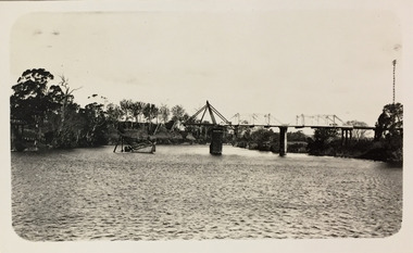
Photograph, J F C Farquhar, Dight's Falls, 1891
At the beginning of the 1890s, the Kew businessman and Town Councillor, Henry Kellett, commissioned J.F.C. Farquhar to photograph scenes of Kew. These scenes included panoramas as well as pastoral scenes. The resulting set of twelve photographs was assembled in an album, Kew Where We Live, from which customers could select images for purchase.The preamble to the album describes that the photographs used the ‘argentic bromide’ process, now more commonly known as the gelatine silver process. This form of dry plate photography allowed for the negatives to be kept for weeks before processing, hence its value in landscape photography. The resulting images were considered to be finely grained and everlasting. Evidence of the success of Henry Kellett’s venture can be seen today, in that some of the photographs are held in national collections.It is believed that the Kew Historical Society’s copy of the Kellett album is unique and that the photographs in the book were the first copies taken from the original plates. It is the first and most important series of images produced about Kew. The individual images have proved essential in identifying buildings and places of heritage value in the district.Dight’s Falls in Studley Park is an artificial weir built on a natural rock bar across the Yarra. The weir was built in the 1840s to provide water to the ‘Ceres’ flour mill, one of the earliest industrial sites in Melbourne. The falls were later to be named after the owner of this mill. In 1888, William Guilfoyle, Director of the Melbourne Botanical Gardens had called for fresh water to be piped from above the weir to the Botanical Gardens, using a pumping station on the Kew side of the Falls, a holding reservoir in Walmer Street and a series of pipes from there to the Gardens. This system was opened in May 1891. Farquhar’s photograph of the man-made weir obscures the industrial activity on both sides of the Falls and focusses solely on the river and the surrounding natural vegetation. The photograph probably predates the disastrous flooding of the Yarra River in July 1891, the greatest to have occurred in the Colony since the foundation of Melbourne.Dight's Fallskew illustrated, kew where we live, photographic books, henry kellett, yarra river -
 Kew Historical Society Inc
Photograph - Bridge over the Tambo River, 1926
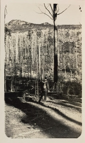
Henry Beater Christian (1886-1962) , was a descendant of one of the earliest settler families in Kew. Employed at the Kew Asylum as a 'public servant', he was a skilled amateur photographer, photographing numerous scenes in Kew and on his travels around Victoria. The majority of his photographs date from 1916 to 1929. His finest photographs are housed in two photograph albums. Digital copy of a photograph from page 31 of the 47-page photograph album containing 261 gelatinous silver images, loaned by Diane Washfold with permission given to digitise and hold a copy in our collection. John Chapman has written in 'Bushwalking Clubs - A Brief History', about the establishment in Victoria of the first bushwalking club in 1888, and the popularisation of bushwalking during the interwar period. Henry Christian's 'walks' appear to have been undertaken solely or with a companion/s. This black and white photo is part of a group of six photos taken on an 18 kilometre walking trip between Bruthen and Swan Reach in East Gippsland in 1926. The route of the walk followed the Tambo River. The photographer has focussed the view on a ruined bridge, presumably caused by a flood, crossing the river. Sections of the left hand pier and span can be seen in the river."BRUTHEN TO SWAN REACH 1926"henry beater christian (1886-1962), landscape photography, christian-washfold collection, photograph albums, bushwalking, bruthen, swan reach, tambo river, east gippsland -
 Kew Historical Society Inc
Photograph - Sunnyside and Mt Wills, c.1926
Henry Beater Christian (1886-1962) , was a descendant of one of the earliest settler families in Kew. Employed at the Kew Asylum as a 'public servant', he was a skilled amateur photographer, photographing numerous scenes in Kew and on his travels around Victoria. The majority of his photographs date from 1916 to 1929. His finest photographs are housed in two photograph albums. Digital copy of a photograph from page 35 of the 47-page photograph album containing 261 gelatinous silver images, loaned by Diane Washfold with permission given to digitise and hold a copy in our collection. John Chapman has written in 'Bushwalking Clubs - A Brief History', about the establishment in Victoria of the first bushwalking club in 1888, and the popularisation of bushwalking during the interwar period. Henry Christian's 'walks' appear to have been undertaken solely or with a companion/s. This black and white photo is part of a group of photos taken in the Victorian High Country. The page is labelled 'Mt Wills / Sunnyside' and includes photos of landscapes and built structures. Mt Wills and Sunnyside were at the time goldfields north of Omeo. This small black and white point-of-view photograph shows the photographer, Henry B Christian, staring across a treed landscape to Mt Wills in the distance."MT WILLS / SUNNYSIDE"henry beater christian (1886-1962), landscape photography, christian-washfold collection, photograph albums, bushwalking, northeast victoria, victorian high country, mt wills, sunnyside -
 Wodonga & District Historical Society Inc
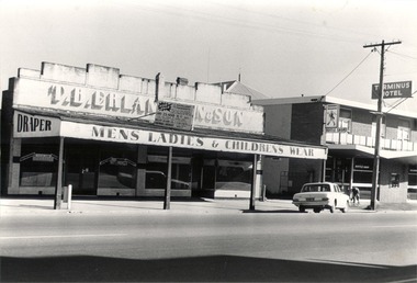
Photograph - Mann Collection Album - Wodonga, High Street West - T. B. Erlandsen & Son. and Terminus Hotel, C. 1980s
Elaine Mann was married to David Mann, a successful Wodonga businessman and community leader who passed away in Wodonga in June 2012. David was a member of the Mann family who began their business in Wodonga in 1920. Elaine was a teacher in Wodonga for many years and an active member of the community.This photo collection is of significance as it documents how the businesses and buildings in Wodonga have evolved and contributed to community throughout the late 20th century.Wodonga, High Street West Businesses including T. B. Erlandsen & Son. and the Terminus Hotel. Thorald Erlandsen purchased his premises in the 1950s. The building was previously owned by John Whan. It started out as a general store but was later extended to include a drapers. The building sold in 1966 to Manns. The Terminus Hotel was built in 1873. It was purchased by Annie and George Allen in 1879. In 1888 they added extensions including a billiard room, a dining room and 18 other rooms. After the death of her husband, Annie Allen continued to run the Terminus Hotel. She later married John Haldon and was licensee of the hotel until 1893 when the license was transferred to William Carkeek. Carkeeks owned the hotel from 1900 - 1903 and again from 1906 - 1909. It was destroyed by fire in 1998 and the building demolished in 1999. In 2021 it is the location of Tristar Medical Centre.wodonga businesses, high st wodonga, t. b. erlandsen & son, terminus hotel -
 Bendigo Historical Society Inc.
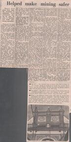
Newspaper - LYDIA CHANCELLOR COLLECTION: THE BENDIGO FUSE FACTORY HELPED MAKE MINING SAFER
A Bendigo Advertiser newspaper article titled 'The Bendigo Fuse Factory by Amy Huxtable.' In 1860 Mr. Charles Perry set up as Proprietor of stamper grating works and was later joined by his nephew Mr. W. Hunter. During this time Mr. Perry worked on a model machine for constructing safer fuses. In 1876 Mr. Charles Perry built a fuse factory in Wattle Street. He refined his machines making them larger and very suitable for building safer fuses. In 1888 the English firm of fuse manufacturers Bickford, Smith & Co., purchased the factory and the secret of the manufacture. In 1912 the Wattle Street building was purchased by Tony Patterson and Huon Matear and was known as the Economic Manufacturing Co. (Bendigo White Works) making underwear. This was followed by Crestknit Industries which ceased operation in 1977. Photos in this article are of Perry's Fuse Factory. 05/02/1977.mining, equipment, fuses, lydia chancellor collection, collection, bendigo, mine, mining, mine safety, mining fuses, mr. charles perry, perry's fuse factory, amy huxtable, w. c. vahland, crestknit industries, manufacturing, perry safety fuse, male, industries -
 Bendigo Historical Society Inc.
Administrative record - Work Book
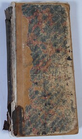
The item is a hard cover book recording weekly work of T.J. Connolly, Ironmongers, Sandhurst. A list of names is written inside the front cover. An alphabetical index at the front of the book, lists types of goods and equipment. The index is followed by handwritten pages recording each week's work including goods, fittings and equipment types, client surname or business name and a numbering system. The work records have also been checked off with ticks or crosses separately. The hard cardboard cover is green with red marbling, which is worn and torn. The leather binding has peeled away from the pages and front cover but is attached to the back cover. The pages are fragile with many loose pages due to the state of the binding. The book is full and includes the date range of 29 May 1886 to 12 October 1888. This item is part of the Margaret Roberts Collection.Business stamp on torn loose page inside front cover. margaret roberts collection, ironmongers, forest street, bendigo businesses -
 Bendigo Historical Society Inc.
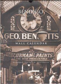
Ephemera - 2013 Bendigo wall calendar
2013 Bendigo wall calendar. 12-month calendar with historic image assigned to each month. January, Bennett's Arcade, 1950's; February, Bendigo Motor Garage, circa 1920; March, Fizelle & Mulqueen Undertakers horse-drawn hearse, circa 1890's; April, Bendigo Easter Fair, circa 1917; May, Bennett's Arcade, circa 1950's; June, Brian Boru Hotel, circa 1920's; July, Myers Flat 'Gold Rush', circa 1867; August, Bendigo Tramways Staff, circa 1910; September, Bendigo Post and Telegraph Office, circa 1888; October, Masonic Hall and Hotel, circa 1900; November, Friedrick & Bassemir Bakery, Bendigo, circa 1910; December, Shamrock Hotel, circa 1890's. Metal coil binding at the top of calendar. bendigo, calendar -
 Bendigo Historical Society Inc.
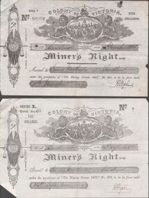
Document - JAMES NORTHCOTE COLLECTION - MINERS RIGHT
Three Miner's Rights in the name of John Northcote, No 90952 dated 11th November 1885, No 7 dated 14th September 1888 and No94 dated 28th August 1893. The first two are for Sandhurst and the third one is for Bendigo. Across the top is a crest with a lion and a unicorn holding up an oval piece with a crown and a lion on top, In the oval is an illustration with two men and a woman and sailing ships in the background. On the left side is another illustration with a Coat of Arms at the top, further down crossed shovel and pick, In the centre two flags with a shield with VR in the centre and a sword behind it. Also in the centre is a set of balance scales. Below is decorative drawing. On the back of two are details of a Residence Area. Also pale green registration No 48198 for James Northcote Miner's Right No7 Date 14/9/88 for a residence area off Thistle and McKenzie Streets, Sandhurst.document, miner's right, miner's right, james northcote, john ferres, robt s brain -
 Warrnambool and District Historical Society Inc.
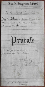
Document - Sarah Fry Probate 1905, 1906
Tait collection: item 27 of 62 This document contains details on the will and probate of Sarah Fry who died in Warrnambool in March 1905 at the age of 47. She was the daughter of Edmund and Jane Lord and came to Australia with her parents and some of her siblings aboard the Electric in 1869. In 1888 she married Francis Joseph Fry, a Warrnambool plasterer. Sarah Fry left real estate to the value of £450 and personal estate to the value of £202. The beneficiaries of her will were her husband, Francis and her three children, Sarah, James and Doris. The lawyer Ernest Chambers had offices in Warrnambool, Koroit and Port Fairy at the end of the 19th century and the beginning of the 20th century. He had this document in his possession and it was passed down to successive lawyers occupying the legal premises in Kepler Street where it was located in 2014 and handed over to the Warrnambool and District Historical Society. This document is of interest as it contains information on the will and probate of Sarah Fry, a resident of Warnambool in the late 19th century and early 20th century. It will be useful for researchers.This is a 1906 cream-coloured parchment sheet folded in two with handwritten material on three sides. Three of the pages are ruled with black ink. There is a seal of the Supreme Court of Victoria attached with a blue ribbon and a red stamp of the Master-in-Equity of the Supreme Court. The document includes the will and probate details of Sarah Fry, a married woman from Warrnambool. All the pages are somewhat stained but one page is very grubby. In the Supreme Court of Victoria; In the Probate Jurisdiction; In the Will of Sarah Fry late of Warrnambool in the State of Victoria Married Woman deceased.ernest chambers, sarah fry, warrnambool, tait collection -
 Warrnambool and District Historical Society Inc.
Boot, Tom Rome, Early 20th century
This boot belonged to Thomas Rome and may have been either an apprentice’s model or a display item in his boot and shoe shop or both. Thomas James Rome (1873-1974) worked in John Younger’s store in Beechworth before both came to Warrnambool in 1888. Rome worked in Younger’s store in Liebig Street, Warrnambool for 17 years and then established his own boot and shoe store at 115 Liebig Street in 1907, retiring in 1962. He married Amelia Saltau and they lived at Murweh at the corner of Liebig and Princess Streets, Warrnambool. Thomas Rome is mostly remembered today for his purchase and use of an Edison phonograph machine in the late 1890s and the sound recordings he made with this machine at the Warrnambool Industrial and Art Exhibition of 1896-7. These recordings were found intact after Rome’s death and are regarded as the earliest sound recordings still surviving in Australia today. This sample boot is of great significant as an example of the bootmaker’s art in the early 20th century and as a memento of Thomas Rome, important in Warrnambool’s history as a businessman and in the history of sound recording in Australia. This is a small sample black leather boot (probably a lady’s boot). It has double ridged stitching across the instep with a soft leather upper part and stitching separating the soft leather section from the smooth leather. The right side of the boot has seven button holes and seven buttons attached with metal clips. The sole is leather with a small heel and the name of the owner stamped on the sole. ‘10’ ‘T.J.Rome’ thomas rome, history of warrnambool, antique lady's boot, leather boot vintage -
 Warrnambool and District Historical Society Inc.
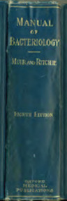
Book, Manual of Bacteriology, 1927
This book was a text book used by Arthur Gregory, the test room technician at Warrnambool Cheese and Butter Factory in the 1930s. He tested the suppliers’ milk and cream for butterfat percentage in order to determine the payment to the suppliers. Arthur Gregory later became the manager of Jays Laundry in Fairy Street. In the 1930s Arthur Gregory boarded at 28 Spence Street in Warrnambool. This boarding house was run by May Taggart, the wife of Sam Taggart, a Warrnambool tailor. Les O’Callaghan was also a boarder there and it was through his contact with Arthur Gregory that he obtained the position of laboratory technician at the Warrnambool Cheese and Butter Factory. Les O’Callaghan remained for over 40 years at this factory (leased at that time by the Kraft company) and was very important in the development of laboratory techniques used in the dairy industry. The Warrnambool Cheese and Butter Factory was established at Allansford in 1888 and is still in production today, operated by the Canadian firm of Saputo. This book is of interest because of its connection to Arthur Gregory, a test room technican at the Warrnambool Cheese and Butter Factory in the 1930s and to Les O’Callaghan, the Laboratory Manager and Microbiologist at Warrnambool Cheese and Butter Factory for more than 40 years. This is a hard cover book of 822 pages. It has a blue cover with gold lettering on the spine. It has 29 chapters, an appendix, a bibliography and an index. It has many black and white illustrations and drawings. The spine is slightly scuffed. The inscription is handwritten in pencil. ‘A.S.Gregory 28 Spence Street W’bool’ warrnambool cheese and butter factory, arthur gregory, warrnambool, les o’callaghan, warrnambool, history of warrnambool -
 Warrnambool and District Historical Society Inc.
Ledger, Ledger (Swinton 1969-1978)
This ledger contains summaries of trading finances for Swintons Pty Ltd and Swintons Supermarket for the years 1969 to 1978. William and Ann Swinton migrated to Australia in 1854 and for a decade William Swinton worked as a builder and carpenter in the Warrnambool district erecting many buildings including the Wangoom Presbyterian Church. In 1865 he opened a store in Timor Street selling groceries, china, glass and hardware. By 1888 the business was known as William Swinton and Sons. Branch stores were opened in Cudgee, Nullawarre, Wangoom, West Warrnambool and South Warrnambool. When William Swinton died his son Robert became the first managing director of Swintons Pty Ltd. In 1934 the business split, with George Swinton and Sons selling furnishings, clothing and glassware and Swintons Pty Ltd selling seeds, hardware and produce. Today the Swinton family still operates a furniture and bedding business in Timor Street. This ledger is of great interest as it contains summaries of the financial records of the Swintons Supermarket and Swintons Pty Ltd from 1969 to 1978. It will be very useful to researchers. The current Swinton business in Timor Street is the oldest family business in Warrnambool and, with the Swinton name associated with businesses in Timor Street for 152 years, it is one of the oldest family businesses in Australia. This is a hard cover book with a green cover. There is black printing on the spine and on the front cover. The pages are white with printed ruled blue lines and printed red and blue columns. The entries are handwritten in blue ink. There are two pages at the back with printed graph patterns.‘Collins Analysis Book 61 Series’swintons family, warrnambool, history of warrnambool -
 Eltham District Historical Society Inc
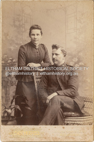
Photograph, F.B. Mendelssohn & Co, Elizabeth Shillinglaw and John Docherty in Salvation Army uniform, c.1890
Elizabeth is not wearing a ring so date is before marriage in 1894 F.B. Mendelssohn & Co operated from Queen's Walk Studios, Victoria Buildings at 80 Swantson Street, Melbourne from 1888-1915 according to Sands McDougall directories CABINET 1866-1905 The Cabinet photo was introduced in 1866 in answer to a demand for a larger format photograph which could be mounted for a cabinet or on the wall. They were 4.5 inches by 6.5 inches (11.5 x 16.5 cm), more than twice the size of the cdv. They cost about twice as much as a cdv but eventually displaced them. They were not extensively produced until 1880 and had ceased by 1905. Coloured mounts, especially maroon or green, indicate a date between 1880 and 1890. - Frost, Lenore; Dating Family Photos 1850-1920; Valiant Press Pty. Ltd., Berwick, Victoria 1991cabinet photo, marg ball collection, shillinglaw family photo album 3, 1888-1915, 1890, elizabeth docherty (nee shillinglaw 1861-1942), john docherty, mendelssohn f.b. & co photographer queens walk melbourne, salvation army -
 Glen Eira Historical Society
Document - Bakewell Family
There are 3 items about this family of early European settlers in Victoria: 1/A photocopy of an extract “Early Pioneer Families of Victoria and Riverina” – Henderson Page 441-442 The Bakewell Family of Burnewang and Tooradin”. It includes a photo of John Bakewell (1807-1888). It contains two pages and describes Bakewell’s property expansion. 2/An original copy of handwritten, unsigned undated research notes on John Bakewell property holdings taken from St Kilda Rate Book (1859-1873). It describes the land allotment. 3/A typed, unsigned, undated extract from 'The Howitts in Australia by Mary Howitt' - Mary Howitt, Vic Hist Mag 1913 Vol 3 No. 1. Reference – Memoirs of a Stockman, Harry Peck, 1853 Map, Foot Plot CCXLVI at Kooyong & Glen Eira Road. It provides a brief outline of the lives of brothers Robert and John Bakewell.the bakewell family, early pioneer families, henderson, bakewell john, port phillip, burnewang, bakewell robert, howitt godfrey dr, lord goderich, tooradin, phoebe, friends' school ackworth, yorkshire, nottingham, shaw john wyberg, plenty river, businesses, goldsbrough richard, goldsbrough mort and company ltd., glaziers, squatters, burnewang, mantons, tooradin, red bluff, torbinurruck, great swamp, brenanah, westernport, numerella, snowy river, orbost, green hills b, caramut, lyall william, mickle john, buckland john, notts, england, balderton, weddings, jane emily, howitt emanuel, farnsfield, lever mary, howitt thomas, heanor, derbyshire, howitt godfrey, scales john, exeter college oxford, downing college cambridge, guerard von, wayne john, south warnborough manor, harrison robert, lord john, jamaica, mary alice, dr. miller, miller john francis compton, emmie joan, mary emily, clifton hotel welbeck street, phoebe alice, anne edith, british museum, land values, settlements, st. kilda, elsternwick, inkerman street, st. kilda east, kew, memoirs of a stockman, harry peck