Showing 2558 items
matching aerial
-
 Bendigo Historical Society Inc.
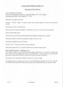
Document - CENTRAL RED, WHITE AND BLUE MINE - OPENING OF NEW BATTERY
Hand written notes and a carbon copy of extracts from Bendigo Advertiser on the opening of New Battery Central Red, White and Blue Co. on Thursd. March 14th 1912. Mentions the machinery, aerial tramway and supports and flying foxes.mine, gold, central red, white and blue mine, central red, white and blue mine, opening of new battery, bendigo advertiser, aerial tramway, flying fox, mining plant -
 Bendigo Historical Society Inc.
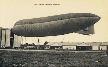
Postcard - BASIL WATSON COLLECTION: POSTCARD - AIRSHIP (ASTRA TORRES), ca. 1914
Black and white postcard . Written on top: 'The Astra Torres Airship' showing side view of tethered airship with personnel below. Airship is outside an airship hanger; aircraft hangers (Montrose base?) in background. 'Our Aerial Defence Series'John Drew, Aldershot & Farnboroughmilitary, aviation, airship 'astra torres' -
 Bendigo Historical Society Inc.
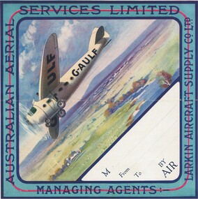
Document - BASIL WATSON COLLECTION: AIRMAIL PARCEL STICKER, c. 1930's
Coloured sticker with an illustration of an aircraft flying over an Australian rural scene. Around the border: Australian Aerial Services Limited - Larkin Aircraft Supply Co Ltd' . Section (blank) for addresses (to and from). No obvious connection with Watson era.person, individual, basil watson -
 National Vietnam Veterans Museum (NVVM)
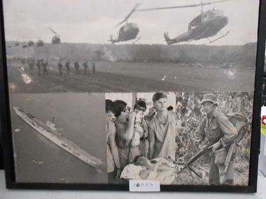
Photograph, Photograph Collage, Vietnam Collection
Photograph Collage of four black and white Photograph. 1. Eight Huey Helicopters landing for Troop Extraction. 2. Aerial photograph of Aircraft Carrier 3. Injured Soldier in Field Hospital. 4. Soldier in Jungle greens with M16photograph, huey helicopter, m16 assult rifle, aircraft carrier -
 Clunes Museum
Map, Surface Geology Plan
Plans show various shaft locations.1 Photocopy of Plan Block 23/19 Scale 1 inch = 100 feet .2 Photocopy of Plan Block 19/19 Scale 1 inch = 100 feet .3 AERIAL PHOTOGRAPH WITH WORKINGS MARKED - LAMINATED.1 C-21 North Broken Hill Ltd Clunes Block 23/19 .2SOUTH CLUNES MINE Ltd Clunes Block 19/19north broken hill ltd, surface geology plan -
 Ballarat Tramway Museum
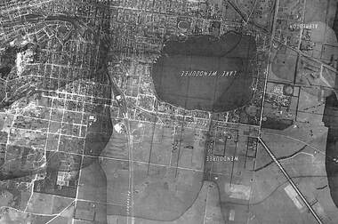
Photograph - Black & White Photograph/s, State of Victoria Lands Department, c1940
Yields information about the development and Lake Wendouree from an aerial photograph c1940.Black and white photograph of an aerial view of the Lake Wendouree and the northern part of Ballarat c1940. Shows the photograph join lines, has names of suburbs, Railway lines. Purchased from rusty via Ebay 16/5/2019.trams, tramways, lake wendouree, ballarat, aerial views -
 Ballarat Tramway Museum
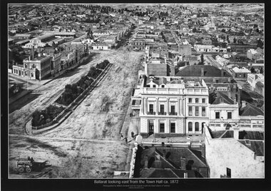
Photograph - Black & White copy, William Bardwell, "Ballarat looking east from the Town Hall ca 1872"
Original photograph by William Bardwell, with the original image held by the State Library of Victoria. Edited by Richard Conn. Purchased by the Museum.Provides information about the appearance of Sturt St Ballarat, looking from the Town Hall. Shows the topography of the area, along with many buildings, including the London Chartered Bank of Australia (later the Commonwealth Bank), the Unicorn Hotel, J. Dodds Bucks Head Hotel, road works in Bridge St, Albion House Drapery, Bryce & Chalmers Produced Merchants, a fenced central median strip and two horse-drawn carriages parked in Lydiard St.Black & White copy photograph aerial view A4 size, titled ""Ballarat looking east from the Town Hall ca 1872" looking along Sturt St towards Grenville St. Original photo by William Bardwell.ballarat, sturt st, grenville st, lydiard st, bucks head hotel, bryce & chalmers, london chartered bank, albion house, bridge st -
 University of Melbourne, Burnley Campus Archives
Plan, Master Plan Burnley Gardens, c.1996
Plan of Burnley Gardens showing P.R.I. (Plant Research Institute) and V.C.A.H. Buildings and Open Space areas. Map used - photogrammetric plot prepared for the V.C.A.H. By Stereometric Services from aerial photography taken 10-7-1988.vcah, burnley gardens, stereometric services, master plan -
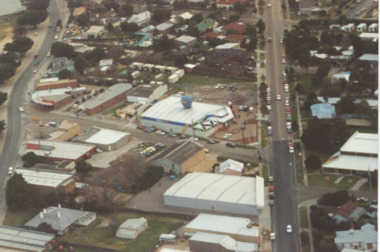
City of Kingston
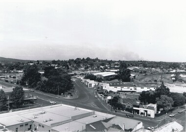
Photograph - Black and white, 27 February 1964
Cheltenham is a suburb in the City of Kingston that was originally established as a rural market gardening community. The area is bordered by Highett. The previous market gardens, farms and paddocks have gradually been sub-divided into housing and industrial estates. The Methodist Children's Home Methodist Homes for Children and St John of God Training Centre on the site of the future Southland shopping centre has not yet been demolished. The recently built Cheltenham High School is visible and the increased urbansation of the area is evident. Some farmland remains including the Le Page homestead.The developing urban area of Cheltenham within the City of Kingston. This image illustrates the mid-century urban sprawl of of Cheltenham and the subdivision of market gardens within the municipality and the changing demographic of the district as new houses are constructed and infrastructure established.Aerial photograph of the suburbs of Cheltenham and Highett within the City of Kingston. Highett Gas Works (top left); Bernard Street, Cheltenham (top right); Weatherall Road (bottom left): Elliott and Cobham Streets Cheltenham (bottom right).White handwritten: X Vic.1831 White type: MELBOURNE 1963 PROJECT RUN23 [underlined] 27-2-64 LENS 205 152-70 M/M 5.150 [arrow] White handwritten: X 166 cheltenham, highett, urbanisation -
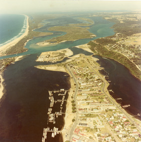
 Lakes Entrance Historical Society
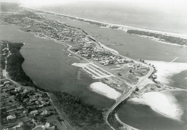
Photograph - Lakes Entrance, 1997
Date made 7 July 1997Colour photograph being an aerial view of entrance at Lakes Entrance, showing the sand hummocks, the sand bar offshore a fishing boat entering the channel through the bar which appears to be recently dredged township of Lakes Entrance Victoria waterways, islands, boats and boating -
 Lakes Entrance Historical Society
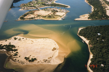
Photograph - Foreshore Lakes Entrance, Bulmer H D, 1923c
Second copyBlack and white photograph showing aerial view of the entrance to the Gippsland Lakes, shows Cunninghame Arm, North Arm, Reeves River and Hopetoun Channel, Rigby Island and Snake Island, the barrier on right foreground. Lakes Entrance Victoriawaterways, islands, aerial photograph, fishing industry, coast -
 Bendigo Historical Society Inc.
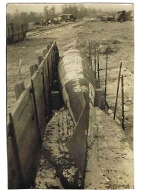
Photograph - ROBERT DENIS KELLY COLLECTION: TORPEDO
Black and white photo: torpedo situated on ground with wooden wall on LH side. Written on back in pencil 'Peronne, a Fritz aerial torpedo, 15 ft. long, 18 inches diameter, 1 1/4 tons in weight'person, robert denis kelly, world war 1, france, torpedo. -
 Lakes Entrance Historical Society
Photograph - Dahlsens Mitre 10, Church Street, Lakes Entrance Victoria, 1/07/1994 12:00:00 AM
Colour photograph of businesses and residences adjacent to the newly opened Dahlsens Mitre 10 store Church Street Lakes Entrance Victoria. Also a second aerial photograph showing closer view of Mitre 10 store slightly blurred businesses, roads and streets, township planning -
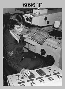 Bendigo Military Museum
Photograph - Army Survey Regiment – Map Production, Fortuna, Bendigo, c1980s
These five photographs of map production and the car park area were taken at Fortuna, Bendigo, c1980s. The first three photographs were taken in Air Survey Squadron, where aerotriangulation and digital photogrammetric extraction of topographic features from aerial photography were undertaken. Photo .4P was taken in Cartographic Squadron’s Correcting Section, located in the Attic. The technicians were probably involved in a rapid response map production, as they all were wearing field uniforms. The Army Survey Regiment’s Duty Room, RAP and Carpark appear in Photo .5P. It was probably taken from the top steps near the SGT’s accommodation block in 1986. Photos .4P and .5P are also published with item 6395.17P.This is a set of five photograph of Map Production and car park, at the Army Survey Regiment, Fortuna, Bendigo, c1980s. The photographs were printed on photographic paper and is part of the Army Survey Regiment’s Collection. Photograph .1P was scanned at 200 dpi. The others were scanned at 300 dpi. .1) - Photo, black & white, c1980s: CPL Marrianne (Van De Zee) De Groot measuring aerial photographs with a stecometer. .2) - Photo, colour, c1980s: Two unidentified technicians assessing a flight line diagram. .3) - Photo, black & white, c1980s: SPR Scheryl Delforce digitising map features on an AUTOMAP 1 Graticon table. .4) - Photo, black & white, 1986: L to R: CPL Andy Lucas, SPR Chris Gordon, unidentified, SPR Jan (Crighton) Minchin, SPR Robin Marshall, CPL Frank Downie, SPR Gayle Humphrey, unidentified technicians in the Attic, Fortuna. .5) - Photo, black & white, 1986: Army Survey Regiment Duty Room, RAP and Carpark at Fortuna. .1P - Annotated on back ‘Maryanne Degroot’ .2P, .4P to .5P – no annotation .3P - Annotated on back ‘Scheryl Delforce’royal australian survey corps, rasvy, army survey regiment, army svy regt, fortuna, asr, air survey, carto, aerotrig -
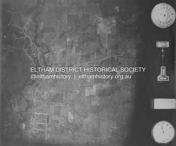
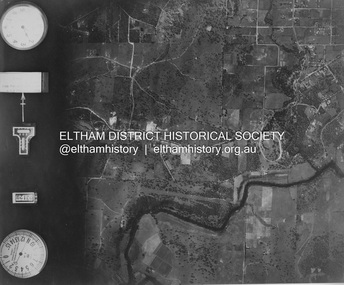 Eltham District Historical Society Inc
Photograph - Aerial Photograph, Landata, Eltham and Lower Plenty, Nov. 1931
Centred over present-day Rosehill Road and View Road, Lower Plenty Historic Aerial Imagery Source: Landata.vic.gov.au Aerial Photo Details: Project No :1931 Project : MALDON PRISON Run : 19 Frame : 3129 Date : 11/1931 Film Type : B/W Camera : F8 Flying Height : 11000 Scale : 18860 Film Number : 60 GDA2020 : 37°44'16"S, 145°07'40"E MGA2020 : 335039, 5821622 (55) Melways : 21 E11 (ed. 42)aerial photo, eltham, lower plenty, neil webster collection, rosehill road, view road -
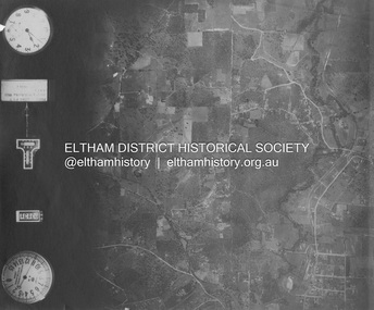 Eltham District Historical Society Inc
Photograph - Aerial Photograph, Landata, Eltham and Eltham North, Nov. 1931
Centred over present-day Opal Court and Manning Road, Eltham North Historic Aerial Imagery Source: Landata.vic.gov.au Aerial Photo Details: Project No :1931 Project : MALDON PRISON Run : 19 Frame : 3131 Date : 11/1931 Film Type : B/W Camera : F8 Flying Height : 11000 Scale : 18860 Film Number : 60 GDA2020 : 37°42'10"S, 145°08'07"E MGA2020 : 335621, 5825531 (55) Melways : 21 G2 (ed. 42)aerial photo, eltham, neil webster collection, eltham north, manning road, opal court -
 Eltham District Historical Society Inc
Photograph - Aerial Photograph, Landata, Eltham and Eltham East, Nov. 1931
Centred over present-day Beard Street bewteen Park Road and Main Road, Eltham East Historic Aerial Imagery Source: Landata.vic.gov.au Aerial Photo Details: Project No :1931 Project : MALDON PRISON Run : 20 Frame : 3135 Date : 11/1931 Film Type : B/W Camera : F8 Flying Height : 11000 Scale : 18860 Film Number : 60 GDA2020 : 37°42'16"S, 145°09'41"E MGA2020 : 337912, 5825386 (55) Melways : 22 B2 (ed. 42)aerial photo, eltham, neil webster collection, beard street, eltham east, main road, park road -
 Eltham District Historical Society Inc
Photograph - Aerial Photograph, Landata, Eltham, Nov. 1931
Centred over present-day Laleham Court between Arthur Street and Hartland Way, Eltham Historic Aerial Imagery Source: Landata.vic.gov.au Aerial Photo Details: Project No :1931 Project : MALDON PRISON Run : 20 Frame : 3136 Date : 11/1931 Film Type : B/W Camera : F8 Flying Height : 11000 Scale : 18860 Film Number : 60 GDA2020 : 37°42'56"S, 145°09'33"E MGA2020 : 337759, 5824139 (55) Melways : 22 B5 (ed. 42) aerial photo, eltham, neil webster collection, arthur street, hartland way, laleham court -
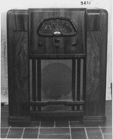 Whitehorse Historical Society Inc.
Audio - Radio & Radio Valves, c1940
Used by uncle of donor, Colin Lawrie, 10 Ruskin Ave Glen Iris - house where donor was born- parents home. Wireless had a beautiful sound, but needed a long aerial.Radio - His Masters Voice - 5 valve superhetrodyne for local and short wave radio reception - electric. Polished veneer cabinet - 4 switches/knobs - tuning; Volume on/off; Local/Short wave; tone. 12inch Rola speaker.|Has been modified with an additional switch at rear to switch on +off. Also include is a box of 14 radio valves. His Masters Voicecommunication, radio -
City of Kingston
Photograph - Black and white, 3 March 1954
Cheltenham and Moorabbin are suburbs within the City of Kingston that were originally established as rural market gardening communities The area is bordered by Highett and Mentone. The market gardens, farms and paddocks have gradually been sub-divided into housing and industrial estates. Highett is developed with residential homes but was also the site of major facilities such as the Highett Gas Works. This aerial image covers a diverse section of the City of Kingston, taking in the suburbs of Moorabbin, Cheltenham, Highett and Mentone Residential housing development is prominent along the Frankston Railway line and the area still retains extensive market gardens and paddocks yet to be converted to a large industrial and commercial zone.Aerial photograph of Mentone, Cheltenham and Moorabbin within the City of Kingston. The area depicted in this 1954 aerial view includes Warrigal Road and Centre Dandenong Road intersection (top left); Charman Road, Patty Street, Bourke Street, Collins Street Mentone (top right); Keys Road Moorabbin (bottom left); Bay Road, Cheltenham (bottom right), Friendship Square, Cheltenham Park, Victoria Golf Club and Jack Barker Oval are visible. Nepean Highway and the Frankston railway line run centrally through the image. Highett Gasworks is also evident.White handwriting and type [indecipherable]. White image of clockface White image of compass White type 42956 Black handwriting 3/3/54 Williams [indecipherable] Black pencil: S [arrow] Black ink: 3/3/1954cheltenham, moorabbin, mentone, highett, market gardens -
 Bendigo Military Museum
Weapon - BOMB, AERIAL 1000 LB, C.1943
This item is situated in the gardens of the Bendigo District RSL Sub Branch Inc Havilah Road Bendigo.Bomb 1000 lb Aerial, metal construction, cylindrical shape, on top are two lifting lugs, rear tapers down with 4 fins inside a circular cover, the nose tapers sharply then forms a smaller impact point. Item is on a stand.On side of the bomb, “No.37 - IMC 1000 LB R&M 9/43”bdrslinc, smirsl, brsl, bomb, 1000 -
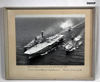 Bendigo Military Museum
Photograph - PHOTOGRAPH RAN, FRAMED, Pre 1964
Black / white aerial photo of HMAS Melbourne with 5 aircraft on the flight deck plus 4 units of the RAN Combat fleet at sea. Photo is mounted with a fawn border with a grey wooden frame, glass front & fawn paper backing.Printed underneath photo in black ink: “H.M.A.S Melbourne and Units of the R.A.N. Combat Fleet” “Presented to Kevin Kelly by his Navy Office friends. Canberra 22nd January 1964” Written on back in pencil : “(Fate of Voyager and Melbourne) H.M.A.S. Voyager collided with H.M.A.S. Melbourne Feb 1964 - 81 lives lost” Written on back In black texta: “(Kevin Kelly)”photographs, hmas, melbourne -
Glenelg Shire Council Cultural Collection
Newspaper - Portland Observer Supplement, 2006
Portland Observer supplement, 2006, celebrating 20 years in the community of Portland Aluminium. Glossy coloured covers, aerial views of smelter on front, smelter staff on back, also on inside of covers. 8 page newspaper insert, history of smelter.portland observer, portland aluminium, alcoa, smelter -
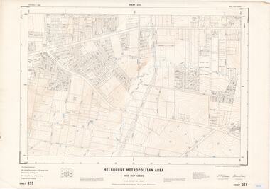
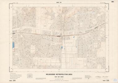 Ringwood and District Historical Society
Map - Melbourne Metropolitan Area Base Map Series, Sheet 235 - Ringwood area, 1960
Map prepared by Dept of Lands and Survey and MMBW from State Aerial Survey June 1957 and Cadastral Survey information August 1960. This sheet comprises parts of Municipalities of Doncaster & Templestowe, Nunawading and Ringwood, and Parishes of Nunawading, Ringwood and Warrandyte.Scale: 400 feet to 1 inch. Contours at 5 feet vertical interval. By Authority: A.C. Brooks, Commonwealth Printer, Melbourne. -
 Ringwood and District Historical Society
Map - Melbourne Metropolitan Area Base Map Series, Sheet 255 - Ringwood area, 1963
Map prepared by Dept of Lands and Survey and MMBW from State Aerial Survey December 1956 and Cadastral Survey information May 1963. This sheet comprises parts of the Municipalities of Ferntree Gully, Nunawading and Ringwood, and Parishes of Nunawading, Ringwood and Scoresby.Scale: 400 feet to 1 inch. Contours at 5 feet vertical interval. By Authority: A.C. Brooks, Commonwealth Printer, Melbourne. -
 Bendigo Historical Society Inc.
Photograph - BENDIGO RAILWAY STATION: AERIAL VIEW, 1995
Black and white photo: aerial view looking trowards Bendigo Railway Station. Mitchell st. runs across lower part of photo. Photo taken prior to building of 'Market place' shopping centre. A 16A black lead on rear.Peter Hyett 1995place, aerial view of bendigo, bendigo railway station -
Bendigo Historical Society Inc.
Photograph - AERIAL PHOTO FORTUNA VILLA
Large black and white aerial photo taken looking north, foreground Fortuna Villa, on right side site where now is St John hospital, top left garden gully oval. There are three copies (one sepia colour).bendigo, streetscape, aerial view -
 Lakes Entrance Historical Society
Photograph - Lakes Entrance, 1975c
Black and white photograph of an aerial view of township and Kalimna Heights, showing the North Arm bridge and boat ramp, sand buildup in the lake system, boat harbour, sand hummocks and beach as far as Red Bluff. Lakes Entrance Victoriaaerial photograph, topography, township -
 Lakes Entrance Historical Society
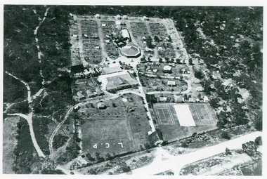
Photograph - Whiter's Camp Park, Bulmer H D, 1935
Black and white aerial view of Whiters Camp Park, looking north from Roadknight Street, showing layout of park including tennis courts, bowling green, picnic area, cottages, rotunda, and the family residence. Lakes Entrance Victoria tourism, camping -
 Lakes Entrance Historical Society
Photograph - Lakes Entrance, 1980c
Colour photograph aerial view of township of Lakes Entrance, showing western end of town, Bullock Island, Cunninghame Arm and North Arm, man made entrance, and distant view of outer barrier, island and shoreline. Lakes Entrance Victoriawaterways, township, bridges