Showing 1526 items
matching aerial photograph
-
 South Gippsland Shire Council
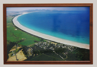
Photograph, Framed, 2003
... Framed colour photograph featuring an aerial view... gippsland Framed colour photograph featuring an aerial view ...Framed colour photograph featuring an aerial view of Waratah Bay, the beach and Sandy Point . Wilsons Promontory can be seen in the distance. -
 Southern Sherbrooke Historical Society Inc.
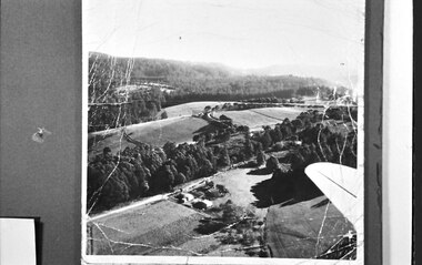
Photograph, Aerial view of Cotswold Valley
Aerial view of Cotswold Valley, Menzies Creek. B&W photos taken from light plane. Paddocks and treed areas are visible. Two houses are in the centre of the photo, presumably the Breen farmhouse on Jacksons Hill Road. The tip of the plane's left wing is also visible. -
 Moorabbin Air Museum
Photograph (Item) - Assorted Aerial Photos Of Lae, Rabaul, Horn Island, Kahili, Buna, Gona , Ballale Island
... Moorabbin melbourne Assorted Aerial Photos Of Lae, Rabaul, Horn ... -
Moorabbin Air Museum
Photograph (Item) - Includes photos of Commonwealth aircraft Corp aerial photos, CAC photos of Macchi MB326H trainer Bell 206 Kiowa
-
 Ballarat Tramway Museum
Photograph - Colour Print, Google Earth, Jan. 2015
Yields information about the South Gardens Reserve and the BTM, including Depot Junction following its redevelopment late 2014.Laminated colour photograph of the South Gardens Reserve Precinct, showing the revised depot junction - completed late Dec. 2014, the fish hatchery, the tram depot with Solar panels, Nov. 2014. Image downloaded from Google Earth 31/3/2015. Has a single trucker on 2 road and 939 on 3 road. See images i2 and i3 for other digital photos prepared from Google Earth at the same time. Image i2 has the solar panels marked by a red arrow.trams, tramways, btm, depot junction, aerial views, solar panels, gardens, fish hatchery -
 Ballarat Tramway Museum
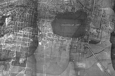
Photograph - Black & White Photograph/s, State of Victoria Lands Department, c1940
... Black and white photograph of an aerial view of the Lake... the development and Lake Wendouree from an aerial photograph c1940. Trams ...Yields information about the development and Lake Wendouree from an aerial photograph c1940.Black and white photograph of an aerial view of the Lake Wendouree and the northern part of Ballarat c1940. Shows the photograph join lines, has names of suburbs, Railway lines. Purchased from rusty via Ebay 16/5/2019.trams, tramways, lake wendouree, ballarat, aerial views -
Moorabbin Air Museum
Photograph (Item) - Photograph album pre WW 2 small prints aerial shots of Melbourne and assorted aircraft
-
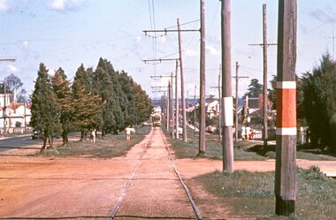 Ballarat Tramway Museum
Slide - 35mm slide/s, Graham Evans, Sep. 1971
Agfa plastic mount (blue base, white cover) of a photograph of a bogie tram on the reserved track between Ophir St and the terminus - telephoto lens. Note tram stop signs, aerial phone lines, the condition of the track and the gravel crossings. Photo taken 9/1971. See also M. Plummer slides Reg. Item 2160 for similar photograph with No. 17. One of a set of 20 slides made by the Association of Railway Enthusiast Provincial Tramways film strip. Reference Item 2560 details the ARE Film Strip and provide references to other slides. Slide rescanned at 3200 dpi 25-10-2020, jpg replaced, tiff file retained. This file was scanned in 2003 and may show colour changes."BAS 70" in pencil.tramways, trams, albert st., sebastopol, ophir st -
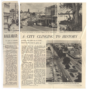 Ballarat Tramway Museum
Magazine, Woman's Day, "Ballarat a City Clinging to History", 8/02/1960 12:00:00 AM
Yields information about the viewpoint of The Courier about the future of the Ballarat tramway system with reference to Geelong.Part page 14 and page 15 of an article titled "Ballarat a City Clinging to History" from the Woman's Day, 8/2/1960, featuring a photograph No. 30, descending Bakery Hill to Bridge St, an aerial view looking west from the Town Hall down and workmen pulling weed from Lake Wendouree. Item looks at Ballarat's history, population, future, Bridge St, the bottleneck of bridge St, quotes Deputy Town Clerk, F. Rogers, and whether the city should grow. Interesting views of traffic in Bridge St. Also quotes Paul Simon of the Bridge St Traders Association. Contained originally within Reg Item 5507 at the back of the binder. For items see btm5507 loose items list.pdftrams, tramways, ballarat, bridge st, bridge st traders -
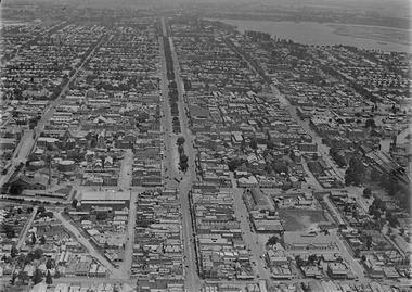 Ballarat Tramway Museum
Photograph - Digital image, c1925
... Ballarat c1925 from an aerial photograph looking west. Trams ...Yields information about Ballarat c1925 from an aerial photograph looking west.Digital photograph of Ballarat looking West c1925, aerial view, looking along Sturt St and Bridge St, taken from about Victoria St and Humffray St. Shows both the Alfred Hall and the Coliseum. Shows two single truckers at the east end of Sturt St. See email from Alan Bradley dated 28/7/2012 re date. See also Reg Item 5454 for another similar photograph.trams, tramways, ballarat, aerial views -
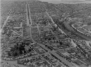 Ballarat Tramway Museum
Photograph - Digital image, c1925
... Ballarat c1925 from an aerial photograph looking west. Trams ...Yields information about Ballarat c1925 from an aerial photograph looking west.Digital photograph of Ballarat looking West c1925, aerial view, looking along Sturt St and Bridge St, taken from about Eureka and Kings St. Shows both the Alfred Hall, the Railway Station, Sunshine Biscuits and the Coliseum. Shows two single truckers at the east end of Sturt St and two at the west end of Bridge St or Grenville St. See email from Alan Bradley dated 28/7/2012 re date. See also Reg Item 5453 for another similar photograph.trams, tramways, ballarat, aerial views -
 Otway Districts Historical Society
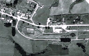
Photograph, R. Preston, Aerial view of Beech Forest railway station and yards, 1965, 13 February 1965
B/W. An aerial view of Beech Forest showing the balloon loop at the end of the station yard (enclosing the two tennis courts), two ex-departmental residences, the station buildings, and other aspects of the township.beech forest: railways; township; aerial; -
 Otway Districts Historical Society
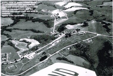
Photograph, R. Preston, Aerial view: Beech Forest, 1965, 13 February 1965
B/W. Aerial view of Beech Forest showing the complete station yard including the balloon loop (incorporating the two tennis courts), two ex-departmental residences, the station building and where the Colac and Crowes lines diverged. As well Beech Forest Hall, council offices and Shire Secretary's house, Denherts Track, and Main Road are shown.beech forest; railways; township; aerial; -
 Queenscliffe Maritime Museum
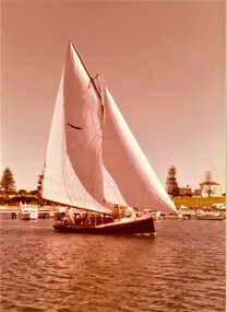
photograph - Photo of Couta boat AERIEL at Portland, AERIEL at Portland, 1986
Couta boatsGarry Kerr's Couta boat AERIAL at Portland, under sail.5 x Colour photographs of the Couta boat AERIAL, owned by Garry Kerr, at PortlandReverse - " NIL "historical references -
 Bendigo Historical Society Inc.
Photograph - MERLE HALL COLLECTION: PHOTOGAPHS OF PAUL MERCURIO (AND PARTNER)
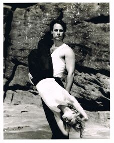
... is of eight performers in vibrant dance poses (mostly aerial). Two ...a. And b. Identical B&W photgraphs of Paul Mercurio and partner (different sizes) Both with typewritten annotation ''Paul Mercurio who will be touring Victoria with his own dance company is pictured with partner Jan Pinkerton. The Australian Choreographic Ensemble have already played a successful season in Sydney and will dance in Melbourne prior to the Victorian tour''. Picture of Mercurio (standing) holding a downwards facing partner in front of rock backdrop.c.: photo of ''the lively young and exuberant dance company formed by Strictly Ballroom star Paul Mercurio limber up before a rehearsal. Annotation - ''the company are preparing to dance their way around Victoria from March 15''. Photo is of eight performers in vibrant dance poses (mostly aerial). Two advertising brochures. -
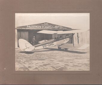 Bendigo Historical Society Inc.
Photograph - T.B.T. Aviation Co
The Bendigo Aero Club laid out the Myers Flat aerodrome in 1929 to serve as an airport for Northern Victoria and the Riverina. In May 1929, 12 machines arrived to give an aerial display to local citizenry.Black and white photograph glued to brown cardboard. Photo of a single engine propeller plane in front of a shed. The sign on the shed reads: T.B.T. Aviation Co. Passenger flights from 10 shillings every Saturday, Sunday and Holiday. Markings on the plane: VH-UHG Eaglehawk. Two men are standing, and one is in the cockpit of the plane. Part of the Barker's family collection.At "Drome" Myers Flat. Left to right: O'Halloran, Cyril James (brother of Emmie Barker nee James), J.S. Barker.myers flat, aviation, tbt aviation -
 Ballarat Tramway Museum
Photograph - Illustration/s, News and Information Bureau - Photo, Ballarat view from Town Hall, Oct. 1958
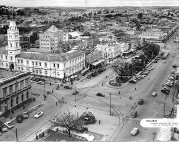
Yields information about the Sturt and Lydiard St streetscape from the Town Hall, c1958.Photograph of intersection of Sturt St and Lydiard St from Town Hall. Looking north east to Black Hill. See also item with Reg. No. 667 of similar but earlier view. Photo is inside cover of ANZ quarterly survey, dated Oct. 1958. Shows four trams in City Loop and good photo of trackwork and motor cars of period. Not to be displayed - before copy neg made.Ballarat - important Provincial Citytrams, tramways, sturt st, black hill, aerial views, trackwork -
 Ballarat Tramway Museum
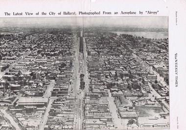
Photograph - Illustration/s, Herald & Weekly Times Ltd, Sturt St. Aerial View, 1934, Jan. 1934
... . Sturt St. Aerial View, 1934 Photograph Illustration/s Herald ...Yields information about Ballarat from the eastern aspect of the city looking west in an aerial view dated 1934. Shows buildings such as the Gas Works and other buildings that no longer exist.Photographic reproduction of Ballarat looking west down Sturt St., page 6 of Magazine section of Weekly Times, Jan 20, 1934. On rear is two colour photo of Alexandria Avenue, Melbourne. Record updated and image added 21/9/2013.trams, tramways, ballarat, sturt st., aerial views -
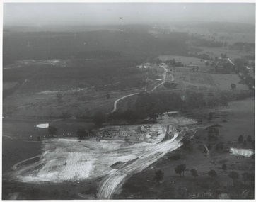 Buninyong & District Historical Society
Photograph - Original Photograph, N.L. Harvey and Sons, Ballarat, B/W photo of early site works Mt. Helen Campus of University of Ballarat, 13 May 1968
Educational historyB/W aerial photo of early site works Mt. Helen Campus of University of Ballarat.On rear, "Tertiary Institute site work at Mt. Helen commenced March 1968 (see A.R. 1967-68, p.8 Knowles and Stapleton had earthworks contract" also stamp " N.L. Harvey & Son Photographers 131 Sturt Street Ballarat"buninyong, mt. helen, ballarat university, campus, earthworks -
 Kew Historical Society Inc
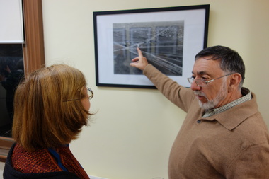
Photograph - Digital Photographs [Series], Robert Baker, Exhibition: Kew From Above, Kew Court House, 2014, 2014
... society - exhibitions exhibition - aerial photographs - kew (vic ...The Kew Historical Society, founded in 1958, is one of the oldest continuing historical societies in the Greater Melbourne region. From its beginnings, the Society has mounted exhibitions and/or displays, in early days in shop windows and in community spaces located in the Kew City Hall (later Kew Library), and since 2010 at the Kew Court House. Exhibitions typically coincided with the annual Kew Community Festival in March, but after 2013 evolved into three new exhibitions yearly at the Kew Court House. Smaller displays continue to be mounted in the Kew Library. A born digital photograph of members and guests at the exhibition opening. Photo 1: L-R Terryl de Lacey, Janet Walker, Don Garden Photo 2: Les Littlechild, Sue Littlechild, Ian Job, ..., ... Photo 3: John Torpey, Slavka Jelovac kew historical society - exhibitions, exhibition - aerial photographs - kew (vic) -
 Kew Historical Society Inc
Photograph, J F C Farquhar, Bird's Eye View Looking West, 1891
At the beginning of the 1890s, the Kew businessman and Town Councillor, Henry Kellett, commissioned J.F.C. Farquhar to photograph scenes of Kew. These scenes included panoramas as well as pastoral scenes. The resulting set of twelve photographs was assembled in an album, Kew Where We Live, from which customers could select images for purchase.The preamble to the album describes that the photographs used the ‘argentic bromide’ process, now more commonly known as the gelatine silver process. This form of dry plate photography allowed for the negatives to be kept for weeks before processing, hence its value in landscape photography. The resulting images were considered to be finely grained and everlasting. Evidence of the success of Henry Kellett’s venture can be seen today, in that some of the photographs are held in national collections.It is believed that the Kew Historical Society’s copy of the Kellett album is unique and that the photographs in the book were the first copies taken from the original plates. It is the first and most important series of images produced about Kew. The individual images have proved essential in identifying buildings and places of heritage value in the district.Before true aerial photography became possible, photographers such as J.F.C. Farquhar were compelled to shoot their images from the highest vantage point. Here, it is presumed to be the roof of Xavier College, from which the panoramic view extends west towards the rise of Studley Park. The houses in the foreground face the southern end of Gellibrand Street. Wellington Street is at an angle to the camera with the Queen Street intersection on the near right. The wooden building behind the large horse paddock on the other side of Gellibrand Street is the Kew Recreation Hall, built 1888, demolished 1960. It was reputed to have one of the finest dancing floors in or around Melbourne. The Bowling Green at the rear of the Hall belonged to the Kew Bowling Club. Further west is the Kew Railway Station on Denmark Street, opened to the public in 1887. At this period, much of Studley Park was locked up in large landholdings, dominated by large mansions such as ‘Byram’. Bird's Eye View Looking Westkew illustrated, kew where we live, photographic books, henry kellett, denmark street, kew recreation hall, kew bowling club, wellington street -
Kew Historical Society Inc
Plan - Pointed Firs Estate, Camberwell North, 1936
Subdivision plans and real estate flyers/brochures reveal a number of aspects of urban development and history. The Kew Historical Society's collection of these plans, as well as advertisements extracted from magazines, cover key aspects of community development and architectural history of Kew and Kew Eat as well as surrounding suburbs. While most of the plans in the collection were gifted to the Society by the former City of Kew, a number of other plans and advertisements have been donated by individuals, of which this is an example.Original multi-page sales brochure of the Pointed Firs Estate, advertised as located in Camberwell North, but now in Balwyn North. The 4-page bifold brochure includes promotional material as well as a detailed plan of the 28 lots for sale, a photograph of the locality with the plan overlaying it, as well as aerial photos and street views. The estate included lots in Doncaster Road, Thackeray Street, Houghton Street, an dMaud Street. pointed firs estate -- balwyn north, subdivisions -- balwyn north (vic.) -
 Kew Historical Society Inc
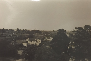
Photograph - Studley Park (Kew), c.1949
... -- Kew (Vic.) aerial photographs -- kew (Vic.) studley park (kew ...An item forming part of a collection of costumes, photographs and documents relating to the Weir family who lived in a mansion, originally named Illapa, at 84 Princess Street, Kew, from c.1917 to 1950. This historically significant collection includes items relating to both George Weir (1866-1937), his wife Edith Mary Weir (1867-1948) and their children. George Weir attained national prominence in the mining industry, becoming General Manager of the North Broken Hill Silver Mining Company in 1903 (later renamed North Broken Hill Mining Company 1905-12, and North Broken Hill Ltd 1912-1988), and subsequently President of the Mine Owners Association. He was to remain General Manager of North Broken Hill Ltd until his retirement in 1926.Small black and white photograph of a panoramic view from the tower of 84 Princess Street, Kew during the occupation of the house by the Weir family during the years 1918-1950. The house and garden had formerly been named Illapa and then Parcnacilla. In 1950 the family sold the house to a religious order who renamed the house 'The Towers'. It now forms part of 'Rylands'.illapa -- 84 princess street -- kew (vic.), aerial photographs -- kew (vic.), studley park (kew) -1930s -
Clunes Museum
Photograph
Aerial coloured photo of Clunes, main buildings named and marked with yellow stickers, mines marked with white stickersaerial, clunes mines, john woodland collection -
 Stawell Historical Society Inc
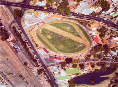
Photograph, Central Park -- Aerial Photo 2007 -- Coloured
... Park -- Aerial Photo 2007 -- Coloured Photograph ...Central Park (Aerial Photo) 2007stawell sport -
 Stawell Historical Society Inc
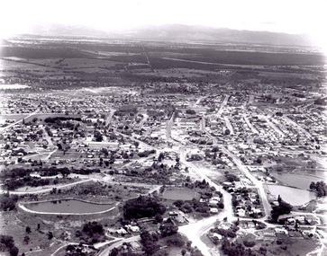
Photograph, Stawell Aerial View 1969
... grampians Aerial View of Stawell 1969 Stawell Stawell Aerial View ...Aerial View of Stawell 1969stawell -
 Stawell Historical Society Inc
Photograph, Stawell Hospital -- Aerial view
... Hospital -- Aerial view Photograph ...Aerial view of Stawell Hospitalstawell hospital -
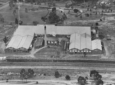 Stawell Historical Society Inc
Photograph, North Western Woollen Mills -- Aerial View, Duplicate of Framed Image
North Western Woollen Mills Aerial Viewstawell industry -
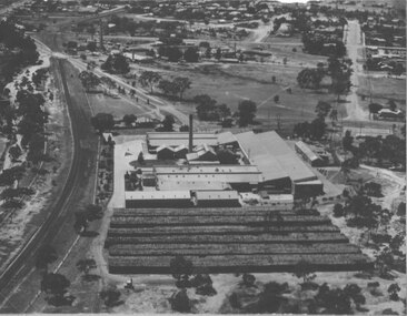 Stawell Historical Society Inc
Photograph, North Western Woollen Mills -- Aerial View, Duplicate of Framed Image
North Western Woollen Mills Aerial ViewUnframed Copystawell industry -
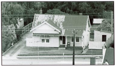
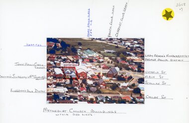 Stawell Historical Society Inc
Photograph, Stawell Methodist Church in Main Street Stawell -- Aerial View showing other buildings as well c1980
Stawell Methodist Church. Main Street Stawell. Aerial View. Shows Croquet Green. Kingston's Bus Depot. Doctors Surgery Mr Gunning's House. C1980stawell