Showing 2441 items matching "orchard"
-
 Eltham District Historical Society Inc
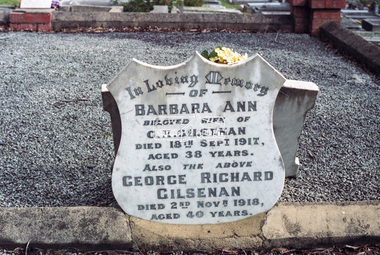
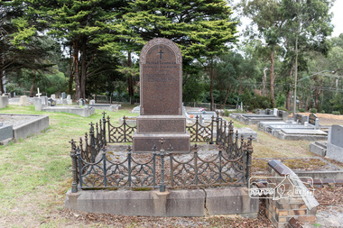
Negative - Photograph, Harry Gilham, Grave of Richard Edward Gilsenan and his wife, Harriet Eliza, Eltham Cemetery, Victoria, 1 Aug 2007
Richard Gilsenan was a retired schoolteacher living at “Rosebank” in Eltham, now the site of the Living and Learning Centre. In 1906, Eltham Primary School’s headmaster John Brown died, and Richard was brought out of retirement (briefly) to be acting headmaster. His son Harold was a junior teacher there at the time. Thereafter, Richard was Secretary of the Eltham Progress League and more importantly was a magistrate at the Eltham Court of Petty Sessions. Cases commonly brought before him included not sending a child to school (typical fine 5/- or eight hours in the lock-up), not having a child vaccinated (fixed fine 40/-), stealing fruit from an orchard, selling liquor out of hours, and offensive language and behaviour. Other miscellaneous cases were allowing cattle to wander, selling cigarettes to a minor, carelessly burning off rubbish on a hot windy day, dumping a dead horse in the Diamond Creek, and youths throwing ripe fruit at passers-by. Richard died in 1920 and is buried in Eltham Cemetery with his wife Harriet Eliza. In mourning his passing, his peers noted that his decisions had been given in a very fair way. Incidentally, his son Harold (the teacher) died in 1921 after being trampled by a horse while en route from Eltham to Cathkin (his then school). In Loving Memory Of Richard Edward Gilsenan Died 30th July 1920 Aged 73 years Also Harriet Eliza Beloved wife of above Died 7th Sept. 1933 Aged 78 years Sweet Rest And In Loving Memory Of Barbara Ann Beloved wide of G. R. Gilsenan Died 18th Sept. 1917 Aged 38 years Also the above George Richard Gilsenan Died 2nd Nov. 1918 Aged 40 yearseltham cemetery, gravestones, memorials, barbara ann gilsenan, george richard gilsenan, harriet eliza gilsenan, richard edward gilsenan -
 Eltham District Historical Society Inc
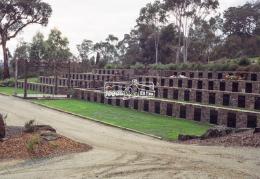
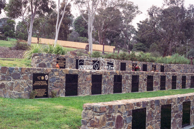
Negative - Photograph, Harry Gilham, Terrace Wall Section, Eltham Cemetery, Mount Pleasant Road, Eltham, 1 Aug 2007
Richard Gilsenan was a retired schoolteacher living at “Rosebank” in Eltham, now the site of the Living and Learning Centre. In 1906, Eltham Primary School’s headmaster John Brown died, and Richard was brought out of retirement (briefly) to be acting headmaster. His son Harold was a junior teacher there at the time. Thereafter, Richard was Secretary of the Eltham Progress League and more importantly was a magistrate at the Eltham Court of Petty Sessions. Cases commonly brought before him included not sending a child to school (typical fine 5/- or eight hours in the lock-up), not having a child vaccinated (fixed fine 40/-), stealing fruit from an orchard, selling liquor out of hours, and offensive language and behaviour. Other miscellaneous cases were allowing cattle to wander, selling cigarettes to a minor, carelessly burning off rubbish on a hot windy day, dumping a dead horse in the Diamond Creek, and youths throwing ripe fruit at passers-by. Richard died in 1920 and is buried in Eltham Cemetery with his wife Harriet Eliza. In mourning his passing, his peers noted that his decisions had been given in a very fair way. Incidentally, his son Harold (the teacher) died in 1921 after being trampled by a horse while en route from Eltham to Cathkin (his then school). In Loving Memory Of Richard Edward Gilsenan Died 30th July 1920 Aged 73 years Also Harriet Eliza Beloved wife of above Died 7th Sept. 1933 Aged 78 years Sweet Rest And In Loving Memory Of Barbara Ann Beloved wide of G. R. Gilsenan Died 18th Sept. 1917 Aged 38 years Also the above George Richard Gilsenan Died 2nd Nov. 1918 Aged 40 yearseltham cemetery, gravestones, memorials -
 Eltham District Historical Society Inc
Negative - Photograph, Harry Gilham, Terrace Wall Section, Eltham Cemetery, Mount Pleasant Road, Eltham, 1 Aug 2007
Richard Gilsenan was a retired schoolteacher living at “Rosebank” in Eltham, now the site of the Living and Learning Centre. In 1906, Eltham Primary School’s headmaster John Brown died, and Richard was brought out of retirement (briefly) to be acting headmaster. His son Harold was a junior teacher there at the time. Thereafter, Richard was Secretary of the Eltham Progress League and more importantly was a magistrate at the Eltham Court of Petty Sessions. Cases commonly brought before him included not sending a child to school (typical fine 5/- or eight hours in the lock-up), not having a child vaccinated (fixed fine 40/-), stealing fruit from an orchard, selling liquor out of hours, and offensive language and behaviour. Other miscellaneous cases were allowing cattle to wander, selling cigarettes to a minor, carelessly burning off rubbish on a hot windy day, dumping a dead horse in the Diamond Creek, and youths throwing ripe fruit at passers-by. Richard died in 1920 and is buried in Eltham Cemetery with his wife Harriet Eliza. In mourning his passing, his peers noted that his decisions had been given in a very fair way. Incidentally, his son Harold (the teacher) died in 1921 after being trampled by a horse while en route from Eltham to Cathkin (his then school). In Loving Memory Of Richard Edward Gilsenan Died 30th July 1920 Aged 73 years Also Harriet Eliza Beloved wife of above Died 7th Sept. 1933 Aged 78 years Sweet Rest And In Loving Memory Of Barbara Ann Beloved wide of G. R. Gilsenan Died 18th Sept. 1917 Aged 38 years Also the above George Richard Gilsenan Died 2nd Nov. 1918 Aged 40 yearseltham cemetery, gravestones, memorials -
 Surrey Hills Historical Society Collection
Photograph, Parer family portrait
Members of the Parer family began arriving in Australia from 1852. By the 1890s several had settled in Surrey Hills and Box Hill. Identification is as follows: Back L to R: Phillip ( ), Stephen, Joseph, Francis. Front L to R: John, Tici, Eulalia, Tia. Phillip lived at 'Monserrat' in Mont Albert Road (land later subdivided so that house was renumbered as a Weybridge Street address. Stephen was was the youngest child of Antonio and Josefa Parer. He left for Australia when he was 17 years old and landed in Melbourne in 1888 and went straight to work at Parers’ Crystal Palace for his brother Francis. Stephen preferred the outdoors and went to work on the family market garden in Box Hill. Joseph was the first Parer to arrive in Australia, in 1855. He and his brother Francis created the Parer dynasty in Australia, bringing all the family members from Spain and offering them work in their hotels. Francis Parer was born in Alella in 1836 and left for Australia when he was 17. In partnership, he commenced a business of general produce dealers in Little Bourke Street. He later entered the hospitality business buying in partnership the ‘Spanish Restaurant’ on Elisabeth Street and later, the Victoria Restaurant on Bourke Street with his brothers. In 1870 he purchased 40 acres of land at Box Hill at £15 per acre. The property became a famous market garden where he grew all kinds of vegetables and orchards. It is believed the first tomatoes in Australia were grown there. Juan or John lived in 'Gerona' in Weybridge Street. Eulalia Parer married Marcus Clota at Alella on 9 September 1867 and came to Australia in 1876. They lived in Guildford and Union Roads. Tia Marieta married and lived in Guildford Road. There are many members of the family buried in Box Hill Cemetery. Black and white formal studio portrait of 8 members of the Parer family mounted on brown board. There are 4 men standing and one man and 3 women seated.White paper label stuck to rear: "THE ORIGINAL PARER FAMILY WHO SETTLED IN AUSTRALIA - 1852. / Photograph with compliments of SANS family."phillip parer, stephen parer, box hill cemetery, joseph parer, francis parer, john parer, tici parer, eulalia parer, tia parer, "monserrat" -
 Surrey Hills Historical Society Collection
Photograph, 44 Guildford Road, Surrey Hills, c1915, 1913-1915
The gentleman in the photo is an estate agent. According to a grandson (REF: Email 1/8/2020) the original photos is thought to have been a publicity photo for the real estate agency. Carl Theodore Offszanka (1874-1944) was born in Germany. He is listed in electoral rolls at 44 Guildford Road from 1915, occupation furrier, with his wife Ida (nee Schade, 1882-1963), also born in Germany. They were married in Victoria in 1908. In later electoral rolls at the same address are Erna Helena (b 1913; d 1996) and Maria Eliese (b 1910; m Benedict Francis Rieusset in 1936). Both daughters are listed as typists. Also listed is Bernard George (b 1914; d 1987) who in later electoral rolls is described as a process worker. He served in the AIF in the Second World War. Not listed is Carl Bernard b 1909. The Offszanka family lived at 44 Guildford Road from 1913 until post-1980; they came to Surrey Hills from Richmond. Their home was called 'Westfalia' (ref: 1919 electoral roll), presumably after the region in NW Germany. It is not known when Carl and Ida migrated from Germany. This home has had a 2nd storey added to it in late 1990s. According to a family descendant (REF: Email 1/8/20 from grandson) Carl Theodor Offszanka purchased the home in 1913 for £616. He also purchased the adjoining vacant block of land at 42 Guildford Road and ran a large orchard on it before later selling it. This appears to have been between 1920-1930. The family continued to occupy the house until after 1980 when Erna Helena and Bernard George are listed in the electoral rolls. Our property register lists Erna Helena Offszanka as the last member there. She died on 5 May 1996. Black and white photo of a ? dark-stained timber Edwardian home at 44 Guildford Road, Surrey Hills. It has 2 brick chimneys, a corrugated iron roof and timber fretwork to the veranda. There is a single window to the veranda, 2 single windows down the LHS (facing) side of the house and a double window to the RHS (facing) side of the house. This appears to have coloured glass to the top section. The gable is decorated with timber and stucco and has a simple finial. The house has a simple timber picket fence and a driveway down the LHS (facing), in which a carriage is located. A gentleman in a hat stands on the veranda. A tall Victorian building can be seen in the far distance, on Canterbury Road.edwardian architecture, houses, guildford road, mr bernard george offszanka, mrs ida offszanka, miss ida schade, miss erna helena offszanka, miss marie eliese offszanker, furriers, mr carl theodor offszanka, westfalia, mr carl bernard offszanka -
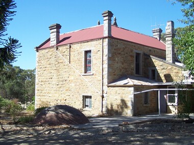 Bendigo Historical Society Inc.
Document - Rocky Vale Beebe House, 2010 to 2015
The Beebe name was well-known in Bendigo in the last quarter of the 19th and the early part of the 20th centuries. From 1875, William Beebe senior, monumental mason, occupied a site in the centre on the city, in Mitchell Street opposite King Street. Death was more part of life in those days, and the Beebes were there to provide the burial monuments. Later, he took his sons into the business, which grew as Beebe and Son. Many examples of their work can be found in the local cemeteries. William Beebe senior (1830-1891) was born in Rutland, the smallest English county in 1830, to stonemason Chamberlain Beebe and Susannah Clements. William emigrated to Victoria in 1854 and after engaging on unknown works in Port Fairy, Dunkeld, and Melbourne arrived in Bendigo. His obituary records that he commenced work here on the site of the Bank of Australasia (opposite the Shamrock Hotel), which would have been no later than 1856. He took up a 13 acre selection on the site of Rocky Vale Villa in 1864 and continued to select or purchase further parcels of adjoining land until he owned some 150 acres, much of it unfit for cultivation. He was a keen gardener and had a garden and orchard around the house. William took over 20 years to build the two-story sandstone and granite house "Rocky Vale Villa". The house was constructed from sandstone sourced "from an adjacent ridge of rocks" (Bendigo Advertiser 28/9/1891). Granite from Harcourt was used for lintels and quoins. Not long before he died, William was still adding to the house. In the Codicil to his will, he states that "I have just built and completed two additional rooms to my Dwelling house situe at Inglewood Road aforesaid" (dated 19/9/1891). William died one week later on the 26th September 1891.Photographs and Historical Documents relating to Rocky Vale Villa, 7 Wicks Road, Maiden Gully, Bendigo by the Bendigo Historical Society.history, bendigo, rocky vale villa maiden gully, william beebe stonemason bendigo -
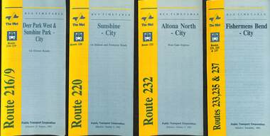 Melbourne Tram Museum
Ephemera - Timetable - bus - The Met - set of 24, The Met, 1992 & 1993
SSet of 24 The Met bus timetables, with diagrammatic map, major stops and contact details. All dated during1993 unless noted otherwise. 1 - Route 216/9 - Deer Park West & Sunshine Park - City 2 - Route 220 - Sunshine - City - 1992 3 - Route 232 - Altona North - City - 1992 4 - Route 233 - Fishermens Bend - City - 1992 5 - Route 254 - Northland Shopping Centre - City - 1992 6 - Route 256 - La Trobe Uni - City - 1992 7 - Routes 258 & 259 - Northland Shopping Centre, and La Trobe Uni - City via Eastern Freeway - 1992 8 - Route 260 etc - Deep Creek Templestow - Donvale - City 9 - Route 264 - Mitcham, Donvale City 10 - Route 265 - Deep Creek - City 11 - Route 602 - Brighton - city 12 - Route 269, 291 and 296 - Greensborough, Heidelberg & Newmans Road to Box Hill 13 - Route 272 - Warrandyte - City 14 - Route 276 & 278 - Warrandyte - City 15 - Route 284 & 270 - East Kew - City or Box Hill 16 - Route 285 - The Pines - Box Hill 17 - Route 286 & 288 - The Pines and Templestowe - Box Hill 18 - Route 290 - North Nunawading - Box Hill 19 - Route 292 etc - Box Hill, Deep Creek, Ringwood, Warrandyte 20 - Route 301, 281 315 - Ringwood, Park Orchards and Donvale - City 21 - Route 305 - Box Hill - Ringwood 22 - Route 366 & 367 - Ringwood - Croydon 23 - Route 600 - St Kilda - Brighton Beach - 1992 24 - Route 601 - Gardenvale - City - 1992Yields information about some of The Met bus services 1993Set of 24 The Met timetables, DL size, printed in two colours.timetables, the met, route 216, route 220, route 232, route 233, route 254, route 258, route 259, route 260, route 264, route 265, route 256, route 602, route 269, route 272, route 276, route 284, route 270, route 285, route 286, route 288, route 290, route 292, route 301, route 305, route 366, route 367, route 600, route 601 -
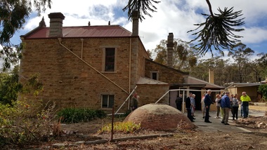 Bendigo Historical Society Inc.
Photograph - Rocky Vale Villa, April 2016
The Beebe name was well-known in Bendigo in the last quarter of the 19th and the early part of the 20th centuries. From 1875, William Beebe senior, monumental mason, occupied a site in the centre on the city, in Mitchell Street opposite King Street. Death was more part of life in those days, and the Beebes were there to provide the burial monuments. Later, he took his sons into the business, which grew as Beebe and Son. Many examples of their work can be found in the local cemeteries. William Beebe senior (1830-1891) was born in Rutland, the smallest English county in 1830, to stonemason Chamberlain Beebe and Susannah Clements. William emigrated to Victoria in 1854 and after engaging on unknown works in Port Fairy, Dunkeld, and Melbourne arrived in Bendigo. His obituary records that he commenced work here on the site of the Bank of Australasia (opposite the Shamrock Hotel), which would have been no later than 1856. He took up a 13 acre selection on the site of Rocky Vale Villa in 1864 and continued to select or purchase further parcels of adjoining land until he owned some 150 acres, much of it unfit for cultivation. He was a keen gardener and had a garden and orchard around the house. William took over 20 years to build the two-story sandstone and granite house "Rocky Vale Villa". The house was constructed from sandstone sourced "from an adjacent ridge of rocks" (Bendigo Advertiser 28/9/1891). Granite from Harcourt was used for lintels and quoins. Not long before he died, William was still adding to the house. In the Codicil to his will, he states that "I have just built and completed two additional rooms to my Dwelling house situe at Inglewood Road aforesaid" (dated 19/9/1891). William died one week later on the 26th September 1891.Photographs of a field trip to Rocky Vale Villa, 7 Wicks Road, Maiden Gully, Bendigo by the Bendigo Historical Society.history, bendigo, rocky vale villa maiden gully, william beebe stonemason bendigo -
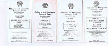 Ballarat Tramway Museum
Ephemera - Timetable/s, Melbourne and Metropolitan Tramways Board (MMTB), Set of 14 MMTB Melbourne bus timetables, 1969
Set of 14 MMTB timetables for various bus routes, dated July 1969. Generally includes Sat and Suns, Good Friday and Christmas day as well as weekdays, unless noted otherwise. Also includes a map of the route, detailed time points, sections, connecting services, fares, and organisation address - 616 Little Collins St. Melbourne. Have been folded into eight or ten portions. All on white paper unless noted otherwise. Items shown with an # - have a sticker modifying timetable information details on the front page. Items shown with a % are larger size sheets of paper, folded into 10. 1155.1 - Clifton Hill - Elsternwick # .2 - Garden City - City # .3 - Fishermen's Bend - City .4 - Box Hill - East Doncaster via Blackburn, Mitcham via Donvale PO and Mitcham - Ringwood via Eastland .5 - Warrandyte via Templestowe, via East Doncaster, Donvale PO - City % .6 - Warrandyte, Park Orchards Ringwood .7 - Williamstown Rd., Footscray Railway Station, Ballarat Rd # .8 - Latrobe University, Northland, West Heidelberg - City # % .9 - Deer Park, Sunshine Park, Sunshine, Footscray - City # .10 - as above, but for Saturdays and Sundays on pink paper # .11 - Box Hill, Heidelberg, Templestowe .12 - Box Hill, North Blackburn .13 - East Kew, Box Hill, Doncaster .14 - Bullen, North Kew - City # % Images of a sample of documents added 16-11-2013. mmtb, timetables, melbourne -
 University of Melbourne, Burnley Campus Archives
Album - Colour prints and negatives, Garden Views, etc, c. 1991
34 colour photographs with negatives. (1) Principal's garage in the Herb Garden area, used for Arboriculture, demolished shortly after in 1992. (2,3)North end of Administration Building. (4) Front of Administration Building. (5,6) Front of Administration Building in winter. (7) ?. (8) Camellia in Emily Gibson Bed. (9) Nursery. (10) Native Garden pool, Andrew Smith, Gardener. (12) Native Garden pool. (13) Melaleuca Lawn. (14)Students outside front of Administration Building. (15-20) Paula Cave, Gardener and Jasmine (in pink) Apprentice working in Herbaceous Border.(21) Students on West side of Administration Building. (22-25) Magnolia in Emily Gibson Bed. (26,27) Pond in a garden not Burnley. (28) Looking through fence to Field Station, Andrew Smith, Gardener. (29) Herbaceous Border and Oak Lawn. (30) Luffmann Ponds and Summer House. (31) Garden view, Wisteria Walk behind. (32) Students in Citriodora Courtyard. (33,34) Students.principal, garage, herb garden, arboriculture, administration building, camellia, emily gibson bed, nursery, native garden, pool, andrew smith, gardener, melaleuca lawn, students, paula cave, gardener, apprentice, herbaceous border, magnolia, ponds, fence, field station, oak lawn, luffmann ponds, summer house, garden views, wisteria walk, citriodora courtyard, lily ponds, orchard -
 Eltham District Historical Society Inc
Photograph - Digital Photograph, Alan King, Panton Hill Hotel, 27 March 2008
Today’s Panton Hill Hotel was built around 1920. Published: Nillumbik Now and Then / Marguerite Marshall 2008; photographs Alan King with Marguerite Marshall.; p61 Panton Hill was originally known as Kingstown, and consisted of only one hotel when the Orams Reef was discovered in 1859. Kingstown was a quartz mining centre and many old mine shafts remain in the area. Orams Reef was one of the first reefs with a rich find of gold in the area. The Hotel Francais, which had been operating in 1861, was well situated on the way to Queenstown (later St Andrews). So was Herr Hirt’s Hotel and store at Smiths Gully. The Kingstown hotel, known as the Frenchman’s and in 1864 as the Hotel de France, was run by a Monsieur Emile Hude and his wife Jeanne, and known for its good food. They hosted social events, business conventions and debates, attracting patrons from as far as Melbourne. The hotel’s name was changed to Panton Hill Hotel in 1905. In 1883 Charles Caudwell built another hotel nearby, possibly in Long Gully Road,3 which it is thought, was burnt down early last century. Today’s Panton Hill Hotel, built around 1920, is the only one of the cluster of buildings in the main road, not to date from around the turn of last century. It was severely damaged by fire in 2003, then underwent extensive alterations. It is the township’s only hotel and is an example of a modest hotel building exterior, constructed early last century. In its early days the hotel also housed the first post office, newsagency and store. Orams Reef yielded a total of £100,000, and fossikers also found alluvial gold in the creeks and gullies, but there is no record of the total value of their finds. Gold greatly increased the Panton Hill population, which peaked between 1865 and 1885. On holidays large sports meetings were held with wood chopping contests and foot races and the day would end with a ball. Miners came from various countries to seek their fortune, including many from China. The Chinese became unpopular however, and gradually left the district, although some stayed and grew and sold vegetables.5 Panton Hill was named after Joseph Panton, who in 1862 was appointed Police Magistrate for the Woods Point, Heidelberg and Yarra districts. Panton was an outstanding man, who in 1852, was Commissioner of Crown Lands and Assistant Commissioner of Goldfields at Bendigo. In 1874 he was promoted to Chief Magistrate for the Melbourne Police. Panton was also an artist, becoming president of the Victorian Arts Society in 1888, and in 1913, president of the Royal Geographical Society. Despite Panton Hill’s prosperity, it still lacked many services as poor roads made access to Melbourne difficult. A horse-drawn mail coach travelled to Melbourne until 1890, when the railway came to Heidelberg. The nearest doctor was at Yarra Glen or Heidelberg, and the Indian hawker Singh’s annual visit was very welcome. A miner’s shack opposite the school was used as a post office. Today’s general store and post office in the main road dates from early last century, and has changed considerably. While most people searched for gold, the more enterprising ones established farms to feed the diggers. Farmers grew wheat, barley and oats, and sent animal skins to the Eltham tannery, to make furs in Melbourne. As gold became scarce from around 1880, miners took up farming on 19 to 20 acre (8ha) allotments. The first settlers in Cherry Tree Road included Purcell, Smith, Owens, Hughes and Shillinglaw. By 1900 all the land had been taken up around Panton Hill and Hurstbridge. The orchards in Panton Hill and the wider district, particularly of apple and pear, were very successful, and made Panton Hill a cohesive and successful community. About 1914 the Moores built the first cool-store and refrigeration plant at their orchard in Cherry Tree Road. Many settlers planted vineyards and made high quality wine, but in 1922 the blight destroyed them.This collection of almost 130 photos about places and people within the Shire of Nillumbik, an urban and rural municipality in Melbourne's north, contributes to an understanding of the history of the Shire. Published in 2008 immediately prior to the Black Saturday bushfires of February 7, 2009, it documents sites that were impacted, and in some cases destroyed by the fires. It includes photographs taken especially for the publication, creating a unique time capsule representing the Shire in the early 21st century. It remains the most recent comprehenesive publication devoted to the Shire's history connecting local residents to the past. nillumbik now and then (marshall-king) collection, panton hill hotel -
 Eltham District Historical Society Inc
Photograph, Peter Pidgeon, Grave of John and Mary Murray, Eltham Cemetery, Victoria, 5 April 2021
Irish-born John Murray and his wife Mary (daughter of Thomas Sweeney) married in 1849 and settled in Eltham North. John and Mary were amongst the earliest inhabitants of Eltham. John was a farmer and their block of about 80 acres, called ‘Laurel Hill’, was on the eastern side of the Diamond Creek, extending east to beyond Zig Zag Road. It was later extended southward by the purchase of a further 60 acres. He is recorded as a supporter on the petition for a school in Eltham and he served on the National School Board of the Eltham school. John died in 1867 and is buried in Eltham Cemetery with Mary and with two of their grandchildren. Their eldest son Johnnie inherited the property. Then in about 1902 his younger brother James purchased about 50 acres on the western side of the Diamond Creek immediately opposite Laurel Hill, extending west to slightly past Wattletree Road. Eltham North Reserve now lies just beyond the southern boundary. James built a family home on top of the hill on the northern boundary, together with a dairy and milking shed and a food cellar. It is thought that the barn with stables was already there. When Johnnie died in 1912, the two properties (though severed by both the creek and the railway line) effectively merged. The land was worked as an orchard with apples, pears, quinces, and possibly apricots and peaches. Later it became a dairy farm. By 1986, almost all the land had been sold off for residential subdivision and the house had been condemned as unfit for habitation. John's grandson Jim retained a small portion of the land and built a new house. He kept the old one as a storage shed, but it was demolished after he died in 1993. The very old barn is still standing. Located in the Roman Catholic section In Memory of John Murray Who died Dec. 1867 aged 50 years Also his wife Mary Murray Who died 7th Sep. 1909 aged 76 years And of their grandchildren Thomas and Mary Ellen DrainBorn Digitaleltham cemetery, gravestones, john murray, mary ellen drain, mary murray, thomas drain -
 Eltham District Historical Society Inc
Photograph, Fay Bridge, Ruins beside the Diamond Creek at Wattle Glen, 13 October 2016
The newly constructed Diamond Creek Trail from Diamond Creek to Wattle Glen completed in February 2021 winds around these ruins just pass the high transmission power lines near Herberts Lane and Collard Drive From Jean Verso, Nillumbik Historical Society, 15 April 2021 William Wandless Herbert bought the surrounding 100 acres in 1852. He was a native of Northumberland and the Scottish Borders who arrived in Melbourne in 1847. The house on the top of the mound would have been built not long after he bought the land; the farm was named "Greenhills". He married Elizabeth Wilson, daughter of John Wilson who had been in Diamond Creek since about 1846. Their first child was born in 1854 so there would be some form of dwelling from about that time. They had eight children who all survived to a good age. His will describes the house as part stone and part wood and of four rooms. Nillumbik Historical Society (NHS) believe it was one of the earliest if not the earliest house, in this part of the district. The remains of the stone house foundations are on top of the mound (photos on the VHD page) and the barn walls are on the north and to the east side of the mound. NHS is not sure how much or which part of the surrounding area was covered by the barns but they were large enough to hold dances after the race meetings that were held in the late 1880's on the adjacent creek flats. It would make sense with the lay of the land that they covered some of the ground to the north and east and used for farm storage, packing sheds for their apple and pear orchards and also for supporting the Nillumbik Gold Mine the family worked to the north up the gully. The path that comes down the gully and runs into the trail goes past the mine site which was on the west side of the gully a couple of hundred metres up from the flats. Heritage Victoria link for the site - https://vhd.heritagecouncil.vic.gov.au/places/12203fay bridge collection, 2016-10-13, diamond creek, diamond creek trail, ruins, wattle glen, william wandless herbert, greenhills, elizabeth wilson -
 Eltham District Historical Society Inc
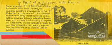
Photograph, Eltham Christian School, severely damaged by a deliberate fire, 10 October 1989, 1989
Part of a personal letter from a church member printed on yellow paper with a black and white photograph. Transcription: "And so home again to .. a fire!! Eltham Christina School and Church, where I worship was extensively burned by a known arsonist on Oct 10 (1998). We lost tthe 3 school rooms and 2/3 of the church. Another school kindly offered classrooms for the children. November 28 and a makesafe wall means school and church are now functioning in the good 1/3 of the church, until the remainder is rebuilt. So many have ministered to us in so many ways over these past weeks and we do thank the Lord for each one." The Stokes family settled in this area of Eltham in the 1940s and were associated with the Eltham Christian Church. In the 1970s this church had met in temporary premises in Eltham. Lots of the original 1920s subdivision remained south of Nyora Road and a number of these lots were utilized for the Eltham Christian School, which was established by the Eltham Christian Church in 1981. The school operated on this site until 2000. The premises were owned by the Nillumbik Community Church who were in operation till November 2010 when the Eltham Baptist Church commenced a lease arrangement until the site was purchased by them in April 2012. The building is constructed of brick and timber with a balcony on two sides that looks over an expanse of grass. Sources: STOKES ORCHARD – AN INCOMPLETE HISTORY February 28, 2015 http://www.elthamhistory.org.au/ Australian Christian Church Histories - Eltham Baptist Church http://www.churchhistories.net.au/church-catalog/eltham-vic-baptist/ From a magnetic spiral bound photo album featuring a series of photographs (some cropped) with captions relating to the staff, students and activities of the Eltham Christian School which operated as part of the Eltham Christian Church at Nyora Road, Eltham. See also entries for each photograph.Typed letter printed on yellow paper with a black and white photographeltham christian school, nyora road, fire damage -
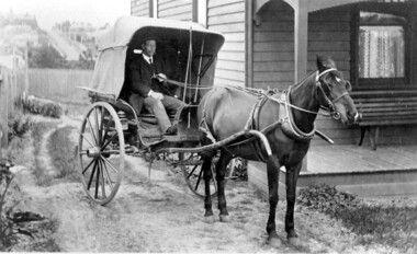 Surrey Hills Historical Society Collection
Photograph, Horse and buggy at 44 Guildford Road Surrey Hills, 1913
Jocelyn Hall indicated in notes that the gentleman could possibly be an estate agent. This was confirmed by a grandson of the original owners. (REF: Email 1/8/2020) The original photos is thought to have been a publicity photo for the real estate agency. Carl Theodore Offszanka (1874-1944) was born in Germany. He is listed in electoral rolls at 44 Guildford Road from 1915, occupation furrier, with his wife Ida (nee Schade, 1882-1963), also born in Germany. They were married in Victoria in 1908. In later electoral rolls at the same address are Erna Helena (b 1913; d 1996) and Maria Eliese (b 1910; m Benedict Francis Rieusset in 1936). Both daughters are listed as typists. Also listed is Bernard George (b 1914; d 1987) who in later electoral rolls is described as a process worker. He served in the AIF in the Second World War. Not listed is Carl Bernard b 1909. The Offszanka family lived at 44 Guildford Road from 1913 until post-1980; they came to Surrey Hills from Richmond. Their home was called 'Westfalia' (ref: 1919 electoral roll), presumably after the region in NW Germany. It is not known when Carl and Ida migrated from Germany. This home has had a 2nd storey added to it in late 1990s. According to a family descendant (REF: Email 1/8/20 from grandson) Carl Theodor Offszanka purchased the home in 1913 for £616. He also purchased the adjoining vacant block of land at 42 Guildford Road and ran a large orchard on it before later selling it. This appears to have been between 1920-1930. The family continued to occupy the house until after 1980 when Erna Helena and Bernard George are listed in the electoral rolls. Our property register lists Erna Helena Offszanka as the last member there. She died on 5 May 1996. The Offszanka family occupied this home from its beginning for over 70 years. Such long-term occupancy by one family is unusual.Black and white photo of a ? dark-stained timber Edwardian home at 44 Guildford Road, Surrey Hills. A hooded buggy is located in the rough driveway at the side of the house. A gentleman in a hat and with a moustache is seated in the buggy. A tall building can be seen in the far distance and a street leading up the hill from Canterbury Road.edwardian style, houses, guildford road, horse drawn vehicle, carl theordore offszanka, miss ida schade, mrs ida offszanka, miss edna helena offszanka, miss marie elsie offszanka, mr bernard george offszanka, estate agent, mr carl bernard offszanka, westfalia -
 Wooragee Landcare Group
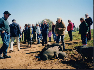
Photograph, 5 September 2004
This photograph was taken at Samaria Farm on Sunday the 5th of September when Wooragee Landcare Group took a bus trip to the Tatong area (near Benalla) to look at land use on small farms. The day trip was organised to observe land use on small farms as well as a social event for the Group. Samaria Farm at the time was a nine-hectare property located in northeast Victoria, near Mount Samaria, 130 km Northeast of Melbourne. The photograph features several pigs believed to be the breed called Large Black. The Large Black Pig breed is a traditional, heritage breed that was first imported to Australia from the UK in the early 1900's. It is believed to have originated from the Old English Hog of the 16th and 17th Centuries. The first reference to them in the Australian Pure Bred Pig Herd Book was in 1912. They are a black pig with lop ears and were prized for their superior milking and mothering abilities and soon became popular with early Dairy Farmers who fed them whey from separated milk as part of their butter making process. They proved economical to keep and, being excellent grazing pigs, were also used to pick up windfall fruit in orchards. Their black colouring also enabled them to withstand the hot Australian summers and avoid sunburn which combined with their hardiness and docile temperament made them highly suitable for free-range pork production, however Large Black pigs tend to get very fat and were not suitable for intensive farming so were often crossed with other breeds for pork production. They are now quite rare as a pure breed having been on the edge of extinction for some time. They were rescued in the early 1990s by a rare breeds farmer in the Yarra Ranges. These days they are also the focus of a small conversation effort with six registered breeders currently in Australia. For biosecurity reasons there are no imports of live pigs or pig semen permitted into Australia. This photograph shows a group of people attending one of the events that Wooragee Landcare Group has organized within the educational framework of promoting best land management practices for all types of land uses and ensuring sustainability, in addition to encouraging community interaction via social events. The Large Black pig breed is significant because of their role in early Victorian farming. They are now quite rare as a pure breed having been on the edge of extinction for some time. These days they are the focus of a small conversation effort with six registered breeders currently in Australia. For biosecurity reasons there are no imports of live pigs or pig semen permitted into Australia. Wooragee Landcare Group is important to local community landcare and environmental management practices.Colour rectangular photograph printed on paperObverse: WAN NA EONA2N2. ANN+ 3 4240/ (No. 17) 370samaria farm, wooragee landcare, wooragee landcare group, tatong, benalla, black pigs, large black, traditional breed, heritage breed, pigs, lop ears, free range pork production, early victorian farming -
 Kew Historical Society Inc
Plan, Melbourne & Metropolitan Board of Works : Borough of Kew : Detail Plan No.1569, 1905
The Melbourne and Metropolitan Board of Works (MMBW) plans were produced from the 1890s to the 1950s. They were crucial to the design and development of Melbourne's sewerage and drainage system. The plans, at a scale of 40 feet to 1 inch (1:480), provide a detailed historical record of Melbourne streetscapes and environmental features. Each plan covers one or two street blocks (roughly six streets), showing details of buildings, including garden layouts and ownership boundaries, and features such as laneways, drains, bridges, parks, municipal boundaries and other prominent landmarks as they existed at the time each plan was produced. (Source: State Library of Victoria)This plan forms part of a large group of MMBW plans and maps that was donated to the Society by the Mr Poulter, City Engineer of the City of Kew in 1989. Within this collection, thirty-five hand-coloured plans, backed with linen, are of statewide significance as they include annotations that provide details of construction materials used in buildings in the first decade of the 20th century as well as additional information about land ownership and usage. The copies in the Public Record Office Victoria and the State Library of Victoria are monochrome versions which do not denote building materials so that the maps in this collection are invaluable and unique tools for researchers and heritage consultants. A number of the plans are not held in the collection of the State Library of Victoria so they have the additional attribute of rarity.Original survey plan, issued by the MMBW to a contractor with responsibility for constructing sewers in the area identified on the plan within the Borough of Kew. The plan was at some stage hand-coloured, possibly by the contractor, but more likely by officers working in the Engineering Department of the Borough and later Town, then City of Kew. The hand-coloured sections of buildings on the plan were used to denote masonry or brick constructions (pink), weatherboard constructions (yellow), and public buildings (grey). This plan covers parts of Sackville Street, John Street, Thomas Street and Cotham Road, and includes several very large houses in Sackville Street. Job Smith built ‘Berrington’ in about 1888-90 for himself, and ‘Pomeroy’ (now ‘Merridale’) in 1885 for James Mickleburgh. ‘Heathfield’ was built in 1888 for Henry Eeles, and was one of many fine homes in Kew, Hawthorn and surrounding suburbs designed by prolific architect John Beswicke; it later became “La Verna” and was a Franciscan monastery. Similarly, in Cotham Road, we can see ‘Bella Vista’ (now demolished), and ‘Charleville’, with its double-storeyed arcade frontage, built in 1889 for Charles Donaldson whose family occupied it until 1939. This was renamed ‘Ross House’ by the second owner, Dr. Thomas King, and then substantially restored in the 1960s by the Stillwell family, well known as car drivers and dealers. Bella Vista (later ‘Malinda’) was originally designed by the architect Robert Haddon and built for Abel Hoadley, inventor of the Violet Crumble Bar and many other delicious delicacies. He began by manufacturing jams and pickles in South Melbourne using fruit from his own orchard in East Burwood.melbourne and metropolitan board of works, detail plans, mmbw 1569, cartography -
 University of Melbourne, Burnley Campus Archives
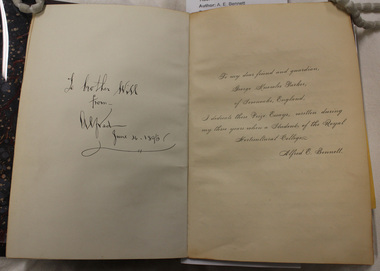
Photograph - Black and white prints and negatives, A.E. Bennett, A.E. Bennett Prize Essays, 1893-1894
Alfred E. Bennett was one of the first students to graduate with a Diploma. He wrote the book after he graduated in 1894. (1) Photographs of photographs, etc. in A.E. Bennett book, "Prize Essays." (i) Acknowledgement for photographs. (ii) p. 101 Appendix. (iii) Diseases of. (iv) Apples. (v) Pioneer timber cottage man and children. (vi) Farm view. (vii) "School of Mines Maryborough. (viii) Group Staff and Students. (ix) "Railway Station Maryborough." (x) "High Street Maryborough." (xi) Maryborough. (xii) Church, Maryborough. (xiii) Maryborough? (xiv) Students and staff seated on horse-drawn cart. (xv, xvi) Distillery equipment. (2) 2 sets of proofs of all photographs in the book. (3) Negatives. Probably taken by A.P. Winzenried for "Green Grows Our Garden." (GGOG). Images used for Media are from B25.0005 as they are the complete collection. Photographs used in GGOG: 26. p9, 11. p10, 25. p12, 5. p22, 19. p29, 15. p32, 27. p 21. The original book is stored with the Burnley Rare Book Collection at the Baillieu Librarya.e. bennett, prize essay, diseases, apples, timber cottage, farm view, school of mines, maryborough, staff, students, railway station, maryborough, church, horse-drawn cart, distillery equipment, a.p. winzenried, green grows our garden, students working outside, orchard, spraying equipment, pruning, planting, orchard gates, entrance gates, neilsons cottage, principal's residence, horticultural board of advice, pavilion, wheelbarrows, californian redwood, sequoia sempervirens, excursion -
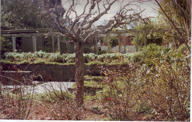
 Eltham District Historical Society Inc
Photograph - Digital Photograph, Marguerite Marshall, Gordon Ford's Garden, 'Fulling', Pitt Street, Eltham, 10 November 2006
'Fulling', the half-hectare property at Pitt Street, Eltham was the home of landscape designer Gordon Ford and his wife Gwen. Ford bought the property in 1948, originally part of an orchard. The garden encapsulates the major trends of Australian garden design in the second half of the 20th century. The garden design is based on mass (plants) and void (paths and pools), textures and forms. It epitomises the Eltham style because of its relaxed informality and attraction to native wildlife. The mud brick house and designed and built by Ford commenced in 1948. Several extensions were added up to 1970 and were built by Graham Rose (Source: information panel for exhibition, n.d.) Covered under Heritage Overlay, Nillumbik Planning Scheme. Published: Nillumbik Now and Then / Marguerite Marshall 2008; photographs Alan King with Marguerite Marshall.; p147 A narrow timber gate opens onto a garden that has had a huge impact on natural garden development in Australia since the 1950s.1 Fulling, the half-hectare property at Pitt St, Eltham, was the home of the landscape designer, Gordon Ford, who died in 1999. The garden ‘encapsulates the major trends of Australian garden design in the second half of the 20th century...and epitomises the Eltham style of garden’.2 It in turn, was influenced by several Victorian major landscape designers of the mid 20th century – Ellis Stones, Peter Glass and Edna Walling. The gate opens onto a sandy gravel path, one of several, which wind around dramatic pools and what appear to be natural bush, but on close inspection are carefully integrated native, indigenous and exotic plantings. Retaining walls and steps of rock through the garden link different terrace levels. Lichen-covered boulders serve as steps across a pool, leading to the triple level mud-brick house. Ford bought the property, which was originally part of an orchard, in 1948. As the son of a Presbyterian minister, Ford received a good education, which included learning Latin. This was advantageous when he worked in plant sales for the Forestry Commission, before the Second World War. In the late 1940s, however, Ford turned to building and landscape gardening. He worked on the Busst house, an early mud-brick building designed by Alistair Knox and at the same time, Ford was employed by Ellis Stones. Knox described Ford as, ‘one of the funniest men of the district. ...Rocky’s (Ellis Stones) Depression stories and Gordon’s memory and quick tongue made the jobs the most enjoyable of all those hysterical times that made Eltham the centre of the eternal laugh, between the years of 1945 and 1950’.3 Ford’s house, like so many after the war, was built progressively, as more space was needed and formerly scarce materials became available. It began with an army-shed of timber-lined walls, now used as the kitchen. Ford then built what is now the lounge room, and the house grew ‘like topsy and on a shoestring,’ says his widow Gwen. A lot of second-hand materials such as window frames were used, a style made famous particularly with their extensive use at Montsalvat, the Eltham Artists’ Colony. The house was constructed as a joint venture with friends, including artist Clifton Pugh, who built Ford’s bedroom for £10. The polished floorboards and solomite (compressed straw) ceilings, interspersed with heavy beams, exude warmth. The result is a home of snug spaces, with soft light and garden vistas. Several other mud-brick buildings were constructed as needed, including a studio and units for bed-and-breakfast clients. The garden, which has been part of the Open Garden Scheme since the mid 1980s, is based on a balance of mass (plants) and void (paths and pools), textures and forms. It epitomises the Eltham style because of its relaxed informal ethos and attracts native animals. Wattlebirds, scrub wrens, pardalotes, currawongs, owls and even kangaroos, have been seen at Fulling. Gwen, a former English teacher who has worked on the garden since around 1970, urged and helped Ford write his book, The Natural Australian Garden.4 Several of Ford’s favourite trees are in the garden, including the native Casuarina or She-Oak. In spring, the garden is dusted with the purple Orthrosanthus multiflorus or blue native irises and rings with the calls of birds attracted to plants like the callistemons, correas and grevilleas.This collection of almost 130 photos about places and people within the Shire of Nillumbik, an urban and rural municipality in Melbourne's north, contributes to an understanding of the history of the Shire. Published in 2008 immediately prior to the Black Saturday bushfires of February 7, 2009, it documents sites that were impacted, and in some cases destroyed by the fires. It includes photographs taken especially for the publication, creating a unique time capsule representing the Shire in the early 21st century. It remains the most recent comprehenesive publication devoted to the Shire's history connecting local residents to the past. nillumbik now and then (marshall-king) collection, eltham, fulling, gordon ford garden, pitt street, eltham mud brick buildings, mud brick house -
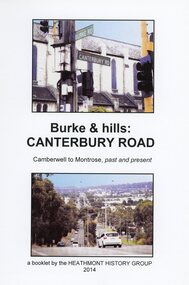 Ringwood and District Historical Society
Book, Burke & Hills: Canterbury Road Camberwell to Montrose, by Heathmont History Group - 2014
Soft cover book of 40 pages with spiral wire spine. Compilation of images and descriptive timeline of the geology, geography and European settlement history of Canterbury Road.Soon after beginning at Burke Road Camberwell, Canterbury Road moves into the gentle hills of Canterbury, then on to Surrey Hills, Box Hill and Forest Hill. Further along past these three "hills" come three "monts" - Vermont, Heathmont and at its other end, Montrose, by then in the foothills of the Dandenongs. Grand homes and churches at one end, major and minor shopping centres along the 25km, factories now where farms were, big box stores, fast food outlets, train stations, resrvoir, traffic, residential stretches, modern apartment blocks, parklands, child-minding centres, sporting ovals, a sewage farm, hotels, quarries, commercial developments, plant nurseries, a golf course, bridges, memorials, Asian food shops, telecommunication towers, bushland, creeks, crossroads, traffic lights, mansions, orchards, swamps ... Delaneys Road, renamed Canterbury Road after a 19th century Victorian Governor, is a fascinating study in land use and history as suburban Melbourne has continually diversified and pushed outwards. Compiled by Heathmont History Group, Rita James, Les Prato, Betty Colbert, Jeff Leipold, Gerry Robinson (convenor). -
 Eltham District Historical Society Inc
Photograph, Peter Pidgeon, Grave of Patrick Carrucan, Eltham Cemetery, Victoria, 5 April 2021
Whilst the three original Carrucan pioneers and their spouses are all buried at Eltham, only one gravestone (that of Patrick Carrucan) exists. Like many of the poor farmers of these early times, their graves were not marked with any permanent stone monuments and have deteriorated to become unmarked graves over the years. Patrick Carrucan, born in 1831 in Ireland, was the second oldest son of Patrick and Bridget Carrucan. He married Mary O'Brien in Ireland in 1856 before migrating to Australia, accompanied by Mary’s father, to join his sister Bridget Coleman in Eltham who had migrated in 1853. Patrick and Mary purchased a farm at the corner of Dalton and Bible Streets, initially living in a hut. After a few years, a more substantial house was built with assistance from Mary's father, who then returned to Ireland. The farm gradually prospered, with cattle, poultry and an orchard. Patrick and Mary had ten children (Bridget, Michael, Susan, Patrick, Thomas, Mary Anne, Catherine, Margaret, Frances and Annie) and lived in Eltham for the rest of their lives. In later years, the Sweeney and the Carrucan families intermarried, as did most of the old Catholic farming families of the Eltham District. Patrick died 6 October 1894 aged 63, reputedly from a broken back after being run over by his own bullock cart. Mary died in 2 Nov 1927 aged 90. They, together with other family members, are buried in a family plot in Eltham Cemetery, though only Patrick is recorded on the gravestone. Patrick's gravestone was in such disrepair that Betty Erickson (nee Carrucan) paid to have a new one erected in the late 1970s. Unfortunately, this gravestone, like the original, only honours Patrick Carrucan and does not record the other family members buried in this family plot. Betty wrote in 1989 "our people were farmers; the Sweeneys well-educated and prosperous, the Carrucans on a somewhat less favoured scale, but solid workers and providers." Patrick Carrucan Who departed this life 6 Oct. 1894 Aged 63 yearsBorn Digitaleltham cemetery, gravestones, patrick carrucan -
 Eltham District Historical Society Inc
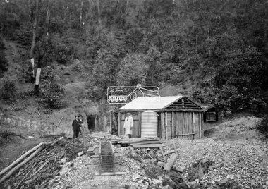
Negative - Photograph, Queenstown (St. Andrews); One Tree Hill Mine, c.1925
L-R: Mr. O. Müller and Mr. John Nink, owners and Mr Müller's son Photograph reproduced on p36 of 'Pioneers & Painters' Gold was discovered on One Tree Hill in 1854. The site has been worked intermittently until fairly recent times (Christmas Hills Past and Present (Yarra Glen & District Historical Society, 2004) ) Advertiser (Hurstbridge, Vic. : 1922 - 1939), Friday 14 November 1930, page 1 ________________________________________ QIJEENSTOWN Death of Mr. John Nink One of the oldest and highly-respected settlers in the person of Mr. John Nink, aged 61 years, passed to his rest on November 10 at his residence, Peach Grove, Queenstown North; after suffering from what is known as miners' complaint. The late Mr. Nink has lived in the district practically all his life and died at the home formerly occupied by his father; Some years ago he conducted a peach orchard, which was one of the sights of Queenstown. He was recently engaged in mining at One Tree Hill with Mr. Otto Muller. He took an active part in public affairs, and was a trustee of the mechanics' institute, recreation ground and cemetery trust. He had a happy disposition, was very hospitable and always merry, which made for him friends all over the district. He leaves a wife, and was the father of Alice (Mrs. Christian), Charles, Robert, William and Minnie (deceased); and the brother of Joseph: (deceased), Henry, Johanna (Mrs. Tonge), Frederick, Mary (Mrs. Antonie) and Robert. His relatives have the sympathy of a large circle of friends in their sad bereavement. The remains of deceased yere interred in Smith's Gully cemetery on Wednesday, and his popularity was shown by the large cortege, amongst the mourners being ex-Cr. Zerbe !(Doncaster), Messrs. Carlyle. Exton, Harris (Kinglake), Birch (Christmas Hills), P. J. McMahon (shire secretary), Crs. Hewitt and Ryan (North Riding), and Cr. D. Murphy (Whittlesea shire). The funeral service was conducted by the Rev. Father Lande (Diamond Creek), and the funeral arrangements were in the hands of Messrs. Apps and Sons.This photo forms part of a collection of photographs gathered by the Shire of Eltham for their centenary project book,"Pioneers and Painters: 100 years of the Shire of Eltham" by Alan Marshall (1971). The collection of over 500 images is held in partnership between Eltham District Historical Society and Yarra Plenty Regional Library (Eltham Library) and is now formally known as the 'The Shire of Eltham Pioneers Photograph Collection.' It is significant in being the first community sourced collection representing the places and people of the Shire's first one hundred years.Digital image (x2) 4 x 5 inch B&W Neg (x2) B&W Print 20 x 25 cm B&W print 9 x 12.5 cmsepp, shire of eltham pioneers photograph collection, queenstown, john nink, o. muller, one tree hill mine, hut, gold mining, one tree hill, goldmining, pioneers and painters, st. andrews, otto johan muller, otto johann müller -
 Eltham District Historical Society Inc
Opening of Meruka Childcare Co-operative, Meruka Park, 5 Meruka Dr, Eltham, April 1994
In 1919 J.B. North, a violinist with the then Melbourne Symphonic Orchestra, and Monsieur Leon Lambert, a French architect, who later designed the Glaciarium Ice Skating Rink, purchased three available farms, Looker's, Wright's and Taylor's, approximately 60 acres, the area running along the creek and being bordered by the present day Ryans Road, Karingal Drive and Sherbourne Road. The farms were used for orchards and market gardens. Leon Lambert designed and built two homes on the farm site, one for the North family, ‘Tralford’, and the other, ‘Glen Ellen’, for himself and his wife. The homes were considered as "brother and sister" and they each included in their design an identical bay window in the main living area. "Glen Ellen" originally comprised kitchen, lounge room, inglenook, dining room, bath room and sleepout. Although the home has been extended over the years, much of the original architecture has been retained including timber panelling and three fireplaces. The land was subdivided in approximately 1966 with "Glen Ellen" retaining approximately one half acre of land fronting Meruka Drive. The property then passed from the Charleston family to Gerald and Margaret Sutton in 1976 and again was sold in 1980 and lastly sold again in 1994. The Norths named their house 'Tralford'. According to Marjorie North, the name Meruka was suggested by Alan Gardner and so was apparently not used by the North family. The name appears to be of Indian origin and its connection with the land is not known. ‘Tralford’ stayed in the North family for many years. Eltham Council acquired the house to create Meruka Park. The house was used for some years by the Council as a community arts facility and as emergency accommodation. It fell into disrepair and was demolished about 1990. The Meruka Child Care Centre has been built on the site and incorporates some of the architectural features of the old house. The Co-op was opened in April 1994. The original drive flanked by large old cypress trees remains. These trees are considered to be of local heritage significance and for this reason Meruka Park is covered by a Heritage Overlay under the Nillumbik Planning Scheme. Part of the park has been preserved as habitat for rare local flora. LL's house, named ‘Glen Ellen’, remains in a well-preserved state and fronts Meruka Drive.cr pam sladden, eltham, meruka child care co-operative, meruka house, meruka park -
 Eltham District Historical Society Inc
Opening of Meruka Childcare Co-operative, Meruka Park, 5 Meruka Dr, Eltham, April 1994
In 1919 J.B. North, a violinist with the then Melbourne Symphonic Orchestra, and Monsieur Leon Lambert, a French architect, who later designed the Glaciarium Ice Skating Rink, purchased three available farms, Looker's, Wright's and Taylor's, approximately 60 acres, the area running along the creek and being bordered by the present day Ryans Road, Karingal Drive and Sherbourne Road. The farms were used for orchards and market gardens. Leon Lambert designed and built two homes on the farm site, one for the North family, ‘Tralford’, and the other, ‘Glen Ellen’, for himself and his wife. The homes were considered as "brother and sister" and they each included in their design an identical bay window in the main living area. "Glen Ellen" originally comprised kitchen, lounge room, inglenook, dining room, bath room and sleepout. Although the home has been extended over the years, much of the original architecture has been retained including timber panelling and three fireplaces. The land was subdivided in approximately 1966 with "Glen Ellen" retaining approximately one half acre of land fronting Meruka Drive. The property then passed from the Charleston family to Gerald and Margaret Sutton in 1976 and again was sold in 1980 and lastly sold again in 1994. The Norths named their house 'Tralford'. According to Marjorie North, the name Meruka was suggested by Alan Gardner and so was apparently not used by the North family. The name appears to be of Indian origin and its connection with the land is not known. ‘Tralford’ stayed in the North family for many years. Eltham Council acquired the house to create Meruka Park. The house was used for some years by the Council as a community arts facility and as emergency accommodation. It fell into disrepair and was demolished about 1990. The Meruka Child Care Centre has been built on the site and incorporates some of the architectural features of the old house. The Co-op was opened in April 1994. The original drive flanked by large old cypress trees remains. These trees are considered to be of local heritage significance and for this reason Meruka Park is covered by a Heritage Overlay under the Nillumbik Planning Scheme. Part of the park has been preserved as habitat for rare local flora. LL's house, named ‘Glen Ellen’, remains in a well-preserved state and fronts Meruka Drive.eltham, meruka child care co-operative, meruka house, meruka park, cr. peter graham, peter staples, richard allen, sheryl garbutt, bill penrose -
 Eltham District Historical Society Inc
Opening of Meruka Childcare Co-operative, Meruka Park, 5 Meruka Dr, Eltham, April 1994
In 1919 J.B. North, a violinist with the then Melbourne Symphonic Orchestra, and Monsieur Leon Lambert, a French architect, who later designed the Glaciarium Ice Skating Rink, purchased three available farms, Looker's, Wright's and Taylor's, approximately 60 acres, the area running along the creek and being bordered by the present day Ryans Road, Karingal Drive and Sherbourne Road. The farms were used for orchards and market gardens. Leon Lambert designed and built two homes on the farm site, one for the North family, ‘Tralford’, and the other, ‘Glen Ellen’, for himself and his wife. The homes were considered as "brother and sister" and they each included in their design an identical bay window in the main living area. "Glen Ellen" originally comprised kitchen, lounge room, inglenook, dining room, bath room and sleepout. Although the home has been extended over the years, much of the original architecture has been retained including timber panelling and three fireplaces. The land was subdivided in approximately 1966 with "Glen Ellen" retaining approximately one half acre of land fronting Meruka Drive. The property then passed from the Charleston family to Gerald and Margaret Sutton in 1976 and again was sold in 1980 and lastly sold again in 1994. The Norths named their house 'Tralford'. According to Marjorie North, the name Meruka was suggested by Alan Gardner and so was apparently not used by the North family. The name appears to be of Indian origin and its connection with the land is not known. ‘Tralford’ stayed in the North family for many years. Eltham Council acquired the house to create Meruka Park. The house was used for some years by the Council as a community arts facility and as emergency accommodation. It fell into disrepair and was demolished about 1990. The Meruka Child Care Centre has been built on the site and incorporates some of the architectural features of the old house. The Co-op was opened in April 1994. The original drive flanked by large old cypress trees remains. These trees are considered to be of local heritage significance and for this reason Meruka Park is covered by a Heritage Overlay under the Nillumbik Planning Scheme. Part of the park has been preserved as habitat for rare local flora. LL's house, named ‘Glen Ellen’, remains in a well-preserved state and fronts Meruka Drive.eltham, meruka child care co-operative, meruka house, meruka park, cr. john cohen -
 Eltham District Historical Society Inc
Opening of Meruka Childcare Co-operative, Meruka Park, 5 Meruka Dr, Eltham, April 1994
In 1919 J.B. North, a violinist with the then Melbourne Symphonic Orchestra, and Monsieur Leon Lambert, a French architect, who later designed the Glaciarium Ice Skating Rink, purchased three available farms, Looker's, Wright's and Taylor's, approximately 60 acres, the area running along the creek and being bordered by the present day Ryans Road, Karingal Drive and Sherbourne Road. The farms were used for orchards and market gardens. Leon Lambert designed and built two homes on the farm site, one for the North family, ‘Tralford’, and the other, ‘Glen Ellen’, for himself and his wife. The homes were considered as "brother and sister" and they each included in their design an identical bay window in the main living area. "Glen Ellen" originally comprised kitchen, lounge room, inglenook, dining room, bath room and sleepout. Although the home has been extended over the years, much of the original architecture has been retained including timber panelling and three fireplaces. The land was subdivided in approximately 1966 with "Glen Ellen" retaining approximately one half acre of land fronting Meruka Drive. The property then passed from the Charleston family to Gerald and Margaret Sutton in 1976 and again was sold in 1980 and lastly sold again in 1994. The Norths named their house 'Tralford'. According to Marjorie North, the name Meruka was suggested by Alan Gardner and so was apparently not used by the North family. The name appears to be of Indian origin and its connection with the land is not known. ‘Tralford’ stayed in the North family for many years. Eltham Council acquired the house to create Meruka Park. The house was used for some years by the Council as a community arts facility and as emergency accommodation. It fell into disrepair and was demolished about 1990. The Meruka Child Care Centre has been built on the site and incorporates some of the architectural features of the old house. The Co-op was opened in April 1994. The original drive flanked by large old cypress trees remains. These trees are considered to be of local heritage significance and for this reason Meruka Park is covered by a Heritage Overlay under the Nillumbik Planning Scheme. Part of the park has been preserved as habitat for rare local flora. LL's house, named ‘Glen Ellen’, remains in a well-preserved state and fronts Meruka Drive.eltham, meruka child care co-operative, meruka house, meruka park, rob hauser -
 Eltham District Historical Society Inc
Opening of Meruka Childcare Co-operative, Meruka Park, 5 Meruka Dr, Eltham, April 1994
In 1919 J.B. North, a violinist with the then Melbourne Symphonic Orchestra, and Monsieur Leon Lambert, a French architect, who later designed the Glaciarium Ice Skating Rink, purchased three available farms, Looker's, Wright's and Taylor's, approximately 60 acres, the area running along the creek and being bordered by the present day Ryans Road, Karingal Drive and Sherbourne Road. The farms were used for orchards and market gardens. Leon Lambert designed and built two homes on the farm site, one for the North family, ‘Tralford’, and the other, ‘Glen Ellen’, for himself and his wife. The homes were considered as "brother and sister" and they each included in their design an identical bay window in the main living area. "Glen Ellen" originally comprised kitchen, lounge room, inglenook, dining room, bath room and sleepout. Although the home has been extended over the years, much of the original architecture has been retained including timber panelling and three fireplaces. The land was subdivided in approximately 1966 with "Glen Ellen" retaining approximately one half acre of land fronting Meruka Drive. The property then passed from the Charleston family to Gerald and Margaret Sutton in 1976 and again was sold in 1980 and lastly sold again in 1994. The Norths named their house 'Tralford'. According to Marjorie North, the name Meruka was suggested by Alan Gardner and so was apparently not used by the North family. The name appears to be of Indian origin and its connection with the land is not known. ‘Tralford’ stayed in the North family for many years. Eltham Council acquired the house to create Meruka Park. The house was used for some years by the Council as a community arts facility and as emergency accommodation. It fell into disrepair and was demolished about 1990. The Meruka Child Care Centre has been built on the site and incorporates some of the architectural features of the old house. The Co-op was opened in April 1994. The original drive flanked by large old cypress trees remains. These trees are considered to be of local heritage significance and for this reason Meruka Park is covered by a Heritage Overlay under the Nillumbik Planning Scheme. Part of the park has been preserved as habitat for rare local flora. LL's house, named ‘Glen Ellen’, remains in a well-preserved state and fronts Meruka Drive.eltham, meruka child care co-operative, meruka house, meruka park, irene bogle -
 Eltham District Historical Society Inc
Opening of Meruka Childcare Co-operative, Meruka Park, 5 Meruka Dr, Eltham, April 1994
In 1919 J.B. North, a violinist with the then Melbourne Symphonic Orchestra, and Monsieur Leon Lambert, a French architect, who later designed the Glaciarium Ice Skating Rink, purchased three available farms, Looker's, Wright's and Taylor's, approximately 60 acres, the area running along the creek and being bordered by the present day Ryans Road, Karingal Drive and Sherbourne Road. The farms were used for orchards and market gardens. Leon Lambert designed and built two homes on the farm site, one for the North family, ‘Tralford’, and the other, ‘Glen Ellen’, for himself and his wife. The homes were considered as "brother and sister" and they each included in their design an identical bay window in the main living area. "Glen Ellen" originally comprised kitchen, lounge room, inglenook, dining room, bath room and sleepout. Although the home has been extended over the years, much of the original architecture has been retained including timber panelling and three fireplaces. The land was subdivided in approximately 1966 with "Glen Ellen" retaining approximately one half acre of land fronting Meruka Drive. The property then passed from the Charleston family to Gerald and Margaret Sutton in 1976 and again was sold in 1980 and lastly sold again in 1994. The Norths named their house 'Tralford'. According to Marjorie North, the name Meruka was suggested by Alan Gardner and so was apparently not used by the North family. The name appears to be of Indian origin and its connection with the land is not known. ‘Tralford’ stayed in the North family for many years. Eltham Council acquired the house to create Meruka Park. The house was used for some years by the Council as a community arts facility and as emergency accommodation. It fell into disrepair and was demolished about 1990. The Meruka Child Care Centre has been built on the site and incorporates some of the architectural features of the old house. The Co-op was opened in April 1994. The original drive flanked by large old cypress trees remains. These trees are considered to be of local heritage significance and for this reason Meruka Park is covered by a Heritage Overlay under the Nillumbik Planning Scheme. Part of the park has been preserved as habitat for rare local flora. LL's house, named ‘Glen Ellen’, remains in a well-preserved state and fronts Meruka Drive.eltham, meruka child care co-operative, meruka house, meruka park, cr bob manuell, matthew rodscholler -
 Eltham District Historical Society Inc
Opening of Meruka Childcare Co-operative, Meruka Park, 5 Meruka Dr, Eltham, April 1994
In 1919 J.B. North, a violinist with the then Melbourne Symphonic Orchestra, and Monsieur Leon Lambert, a French architect, who later designed the Glaciarium Ice Skating Rink, purchased three available farms, Looker's, Wright's and Taylor's, approximately 60 acres, the area running along the creek and being bordered by the present day Ryans Road, Karingal Drive and Sherbourne Road. The farms were used for orchards and market gardens. Leon Lambert designed and built two homes on the farm site, one for the North family, ‘Tralford’, and the other, ‘Glen Ellen’, for himself and his wife. The homes were considered as "brother and sister" and they each included in their design an identical bay window in the main living area. "Glen Ellen" originally comprised kitchen, lounge room, inglenook, dining room, bath room and sleepout. Although the home has been extended over the years, much of the original architecture has been retained including timber panelling and three fireplaces. The land was subdivided in approximately 1966 with "Glen Ellen" retaining approximately one half acre of land fronting Meruka Drive. The property then passed from the Charleston family to Gerald and Margaret Sutton in 1976 and again was sold in 1980 and lastly sold again in 1994. The Norths named their house 'Tralford'. According to Marjorie North, the name Meruka was suggested by Alan Gardner and so was apparently not used by the North family. The name appears to be of Indian origin and its connection with the land is not known. ‘Tralford’ stayed in the North family for many years. Eltham Council acquired the house to create Meruka Park. The house was used for some years by the Council as a community arts facility and as emergency accommodation. It fell into disrepair and was demolished about 1990. The Meruka Child Care Centre has been built on the site and incorporates some of the architectural features of the old house. The Co-op was opened in April 1994. The original drive flanked by large old cypress trees remains. These trees are considered to be of local heritage significance and for this reason Meruka Park is covered by a Heritage Overlay under the Nillumbik Planning Scheme. Part of the park has been preserved as habitat for rare local flora. LL's house, named ‘Glen Ellen’, remains in a well-preserved state and fronts Meruka Drive.eltham, meruka child care co-operative, meruka house, meruka park, cr pam sladden, mandy press