Showing 4562 items matching "the avenue"
-
![Photograph - Digital Image, 10-12 Poulter Avenue [down driveway], 2015_](/media/collectors/4f729f5697f83e03086015b8/items/581981d0d0cdd11ed40d3450/item-media/581981ffd0cdd11ed40d4a3f/item-fit-380x285.jpg) Greensborough Historical Society
Greensborough Historical SocietyPhotograph - Digital Image, 10-12 Poulter Avenue [down driveway], 2015_
Built circa 1930s this timber house has 6 rooms and fronts Poulter Avenue Greensborough. It was for sale in 2015 and photographs were taken by a GHS member.These older home sites are being redeveloped and photos give some idea of how Greensborough looked in the early 20th century.Digital copy of colour photograph. -
 Greensborough Historical Society
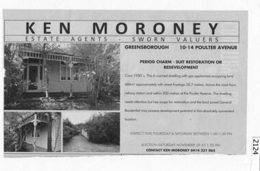
Advertisement - Newspaper Clipping, 10-14 Poulter Avenue Greensborough, 29/11/2014
Advertisement for auction on 29/11/2014 of property at 10-14 Poulter Avenue Greensborough. Not sold at auction, for private sale January 2015. No further details.News clipping, black text, colour image.poulter avenue greensborough -
 Greensborough Historical Society
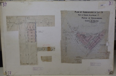
Planning Document, Subdivision Plan # 37. Poulter Avenue and Bicton Street; and, Adeline Street and Grimshaw Street Greensborough, 1971_
Plan of subdivision Lot 29, Part of Crown Allotment, Parish of Keelbundoora, County of Bourke. Poulter Avenue and Bicton Street; and, Adeline Street and Grimshaw Street.An example of hard copy subdivision plans from the Greensborough area. Mainly from the Shire of Diamond Valley era (1964-1994).Plan (2 sheets) mounted on heavy card. subdivision plans, grimshaw street, poulter avenue, adeline street -
![Photograph - Digital Image, 10-12 Poulter Avenue [front of house], 2015_](/media/collectors/4f729f5697f83e03086015b8/items/5819823ad0cdd11ed40d6877/item-media/58198262d0cdd11ed40d995b/item-fit-380x285.jpg) Greensborough Historical Society
Greensborough Historical SocietyPhotograph - Digital Image, 10-12 Poulter Avenue [front of house], 2015_
Built circa 1930s this timber house has 6 rooms and fronts Poulter Avenue Greensborough. It was for sale in 2015 and photographs were taken by a GHS member.These older home sites are being redeveloped and photos give some idea of how Greensborough looked in the early 20th century.Digital copy of colour photograph. -
![Photograph - Digital Image, 10-12 Poulter Avenue [front verandah], 2015_](/media/collectors/4f729f5697f83e03086015b8/items/581982b2d0cdd11ed40dcaeb/item-media/581982fed0cdd11ed40e0624/item-fit-380x285.jpg) Greensborough Historical Society
Greensborough Historical SocietyPhotograph - Digital Image, 10-12 Poulter Avenue [front verandah], 2015_
Built circa 1930s this timber house has 6 rooms and fronts Poulter Avenue Greensborough. It was for sale in 2015 and photographs were taken by a GHS member.These older home sites are being redeveloped and photos give some idea of how Greensborough looked in the early 20th century.Digital copy of colour photograph. -
![Photograph - Digital Image, 10-12 Poulter Avenue [kitchen], 2015_](/media/collectors/4f729f5697f83e03086015b8/items/5819830fd0cdd11ed40e1ba2/item-media/58198330d0cdd11ed40e3e55/item-fit-380x285.jpg) Greensborough Historical Society
Greensborough Historical SocietyPhotograph - Digital Image, 10-12 Poulter Avenue [kitchen], 2015_
Built circa 1930s this timber house has 6 rooms and fronts Poulter Avenue Greensborough. It was for sale in 2015 and photographs were taken by a GHS member.These older home sites are being redeveloped and photos give some idea of how Greensborough looked in the early 20th century.Digital copy of colour photograph. -
![Photograph - Digital image, 10-12 Poulter Avenue [Lounge], 2015_](/media/collectors/4f729f5697f83e03086015b8/items/58198349d0cdd11ed40e4a20/item-media/58198374d0cdd11ed40e69ad/item-fit-380x285.jpg) Greensborough Historical Society
Greensborough Historical SocietyPhotograph - Digital image, 10-12 Poulter Avenue [Lounge], 2015_
Built circa 1930s this timber house has 6 rooms and fronts Poulter Avenue Greensborough. It was for sale in 2015 and photographs were taken by a GHS member.These older home sites are being redeveloped and photos give some idea of how Greensborough looked in the early 20th century.Links: 01339.01377.01406.01483.01488.01527.01653 Digital copy of colour photograph. -
 Ballarat Base Hospital Trained Nurses League
Ballarat Courier - John Ross, hospital gardener - planted rhododendron in 1860's
John Ross died June 1926, aged 86 years. Buried Ballarat Old Cemetery - Avenue, Sect 3, Row 1, Grave 16.Newspapercourier, john, ross, hospital, gardener, rhododendron, 1860's -
 8th/13th Victorian Mounted Rifles Regimental Collection
Photograph - Blok and Madjeric
Formal Dinner at Sisley Avenue Depot Wangarattta to mark the retirement of Colonel John Neale as Honorary Colonel of 8/13 Victorian Mounted Rifles regiment.Colour photograph of Sergeant Blok and former Warrant Officer Class 2 Lou Madjeric at Formal Dinner, Wangaratta 20 June 1992 blok, madjeric, wangatta -
 Bendigo Historical Society Inc.
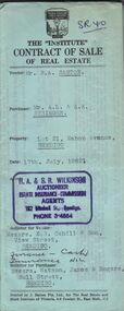
Document - H.A. & S.R. WILKINSON COLLECTION: CONTRACT OF SALE
Contract of sale of real estate between Mr. R.A. Santon (vendor) and Mr. A.L. & A.K. Stringer (purchaser) dated 17th, July, 1962. Solicitor for vendor: Messrs. E.S. Cahill & Son, View Street, Bendigo. Solicitor for purchaser: Messrs Watson, James & Rogers, Bull Street, Bendigo. Property: Lot 21, Mahon Avenue, Bendigo, being lot 21 on plan of subdivision no. 31961 lodged in the office of titles parish of Sandhurst and being the whole of the land comprised in certificate of title volume 8310 folio 930 having a frontage of 53 feet to Mahon Avenue by a depth of 120 feet. Price 550 pounds.organization, business, h.a. & s.r wilkinson real estate -
 Kew Historical Society Inc
Plan - Subdivision Plan, Jas R Mathers Son & McMillan, Clifton Estate, Kew, c. 1916
Pru Sanderson, in her groundbreaking ‘City of Kew Urban Conservation Study : Volume 2 - Development History’ (1988), summarised the periods of urban development and subdivisions of land in Kew. The periods that she identified included 1845-1880, 1880-1893, 1893-1921, 1921-1933, 1933-1943, and Post-War Development. These periods were selected as they represented periods of rapid growth or decline in urban development. An obvious starting point for Sanderson’s groupings involved population growth and the associated economic cycles. These cycles also highlighted urban expansion onto land that was predominantly rural, although in other cases it represented the decline and breakup of large estates. A number of the plans in the Kew Historical Society’s collection can also be found in other collections, such as those of the State Library of Victoria and the Boroondara Library Service. A number are however unique to the collection.The Kew Historical Society collection includes almost 100 subdivision plans pertaining to suburbs of the City of Melbourne. Most of these are of Kew, Kew East or Studley Park, although a smaller number are plans of Camberwell, Deepdene, Balwyn and Hawthorn. It is believed that the majority of the plans were gifted to the Society by persons connected with the real estate firm - J. R. Mathers and McMillan, 136 Cotham Road, Kew. The Plans in the collection are rarely in pristine form, being working plans on which the agent would write notes and record lots sold and the prices of these. The subdivision plans are historically significant examples of the growth of urban Melbourne from the beginning of the 20th Century up until the 1980s. A number of the plans are double-sided and often include a photograph on the reverse. A number of the latter are by noted photographers such as J.E. Barnes.The Clifton Estate was an ambitious subdivision. It included 61 allotments bordering Cotham and Park Hill Roads, and Florence and Adeney Avenues. It is difficult to ascertain the exact year when the ‘Clifton Estate’ was surveyed, subdivided and first auctioned. The uncertainty may be due to allotments being released during the First World War. The subdivision took its name from the house ‘Clifton’ (lot 5) on the corner of Adeney Avenue and Cotham Road. The outline of Clifton (since demolished) and the extent of its land following the subdivision are represented on the plan. The auctioneers have also shown ‘Maryfield’ and ‘Wimba’, the neighbouring properties in Cotham Road, on the plan."B"subdivision plans - kew, clifton estate, cotham road, adeney avenue, florence avenue, park hill road -
 Phillip Island and District Historical Society Inc.
Photograph, ?
One of a collection of photographs purchased from Photo First, Thompson Avenue, Cowes, when it closed in June, 2014. The bridge was built in 1939 and opened in November 1940. Large Black & White photograph of Phillip Island Suspension Bridge, the first bridge from San Remo to Newhaven.phillip island suspention bridge, suspension bridge, photo first phillip island -
 Phillip Island and District Historical Society Inc.
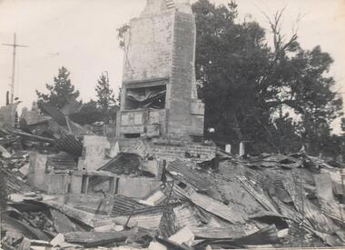
Photograph, Isle of Wight Hotel Fire, 23/04/1925
Photograph taken by Jessie Smith ("Girlie") of San Remo who owned the Penguin Cafe in Thompson Avenue, Cowes, Phillip Island One of the Jessie Smith Collection.Black & White photograph of the scene after fire. Chimney remaining standing. Isle of Wight Hotel. 23/4/1925phillip island, isle of wight, phillip island, jessie smith, isle of wight fire, phillip island -
 Greensborough Historical Society
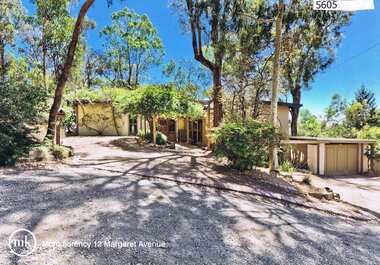
Advertising Leaflet, 12 Margaret Avenue Montmorency, 23/03/2013
12 Margaret Avenue Montmorency. 4 bedroom home, Alistair Knox mudbrick and timber, on 1150 sq m., auctioned 23 February 2013, sold for $775,000Real estate advertising leaflet, 1 sheet, printed in colour both sidesmargaret avenue montmorency -
 Ringwood and District Historical Society
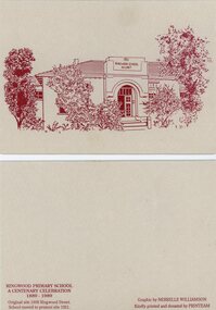
Card - Commemorative Stationery, Printeam, Ringwood Primary School 2997: cards and etching of 1921 school. 1989, 1989
Card printed for the centenary celebration of Ringwood Primary School 1889-1989. Original site in 1898 Ringwood Street. The school moved to Greenwood Avenue site in 1921.Four buff coloured cards and envelopes with etching in red ink of 1921 Ringwood School no. 2997.Graphic by Nerrelle Williamson -
 Whitehorse Historical Society Inc.
Photograph, Ireland family
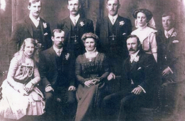
William Ireland was an orchardist in Mitcham. His cool store stood on the corner of Deakin Street and Ormond Avenue, Mitcham, behind the family's home in Gillies Street, MitchamBlack and white photograph of the Ireland family of Mitcham c1910 Back row: Henry, Albert, Alfred, Alice, Arthur Front row: Myrtle, Edward, Kezia d. 1914 aged 56, William Absent: Elijah d. 1908 aged 50, Amelia (Halliday), Emily d.1892 aged 4 years 7 months, John d. 1902 aged 27, and Rose d.1905 aged 12 years. There was also one still born child.ireland family, orchards -
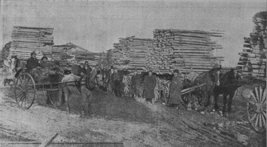 City of Ballarat Libraries
Photograph - Card Box Photographs, Tree guards on wagons, Avenue of Honour, Ballarat 1919
10 wagon loads of tree guards were used to protect the Avenue of Honour trees. Donations were collected by the Lucas Girls, organised by Mrs Tillie Thompson.avenue of honour, vehicle, people -
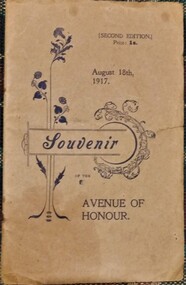 Hymettus Cottage & Garden Ballarat
Booklet - Souvenir Booklet, Souvenir: Avenue of Honour
non-fictionwar memorial, ballarat, avenue of honour, tourism -
 Ringwood and District Historical Society
Document - Extract from book "Bush Town to City" (Croydon, Victoria), Severance from the Shire of Lillydale 1952-1961
Addendum to folder of Estate Agent's notes compiled in preparation for property auction, "Shadowood", 74-76 Alto Avenue, Croydon, Victoria, 11th October, 2008. Ten pages plus map detailing the history of the severance of Croydon from Lillydale written by Robert Federick Jensen. -
 Ringwood and District Historical Society
Photographs, 1977 photographs of Ringwood railway station and surrounding areas
629_001.jpg - Sept 1977 photo of Station St, corner of Greenwood Avenue 629_002.jpg - Sept 1977 photo of railway line looking north to Alan Coffey Motors 629_003.jpg - Sept 1977 photo of Ringwood railway station showing southern carpark -
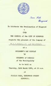 Ringwood and District Historical Society
Photograph, Invitation to celebration of the proclamation of Ringwood as a City on 24th March 1960 at Jubilee Park, Greenwood Avenue - a Children's Day Display by students of schools of the municipality. To Cr RC Horman JP and Gwen Horman
Invitation to celebration of the proclamation of Ringwood as a City on 24th March 1960 at Jubilee Park, Greenwood Avenue - a Children's Day Display by students of schools of the municipality. To Cr RC Horman JP and Gwen Horman. All material is from Gwen Horman’s three albums that she owned. -
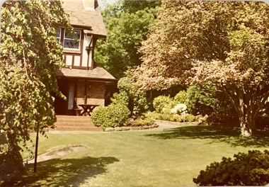 Kew Historical Society Inc
Photograph, 2 Daracombe Ave, Kew, 1950s, 1950s
Photograph of a garden in KewA colour photograph, dating from the 1950s of the garden of 2 Daracombe Avenue, Kew. This view of the garden of the Beck family house was donated by Anita Beck at the time of the historic garden exhibition at the Kew Court House in 2016. The Beck family occupied the house from the 1950s to 2009. Inscription to reverse: "2 Daracombe Ave 1950s to 2009 / Beck family".daracombe avenue (kew), gardens -- kew -
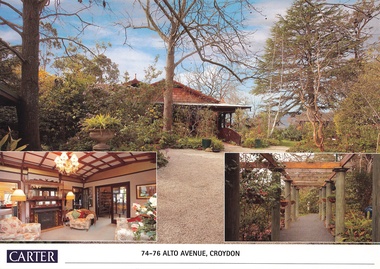 Ringwood and District Historical Society
Document, Real Estate History of "Shadowood", 74-76 Alto Avenue, Croydon, Victoria
Folder of Estate Agent's notes compiled in preparation for property auction, 11th October, 2008. Two-page history of "Shadowood", display photo of house with floor plan dating from circa 1920s, copies of LANDATA title documents. Map of Wicklow Hills subdivision, including Alto Avenue, Elesmere Avenue, Glenora Avenue, Wicklow Avenue, and railway line to Lilydale. Title Vol 1323 Fol 264412 Allotment 43C Parish of Warrandyte - Ann McKean, dated 6th October, 1881. Title Vol 1937 Fol 387367 Part of Allotment 43C Parish of Warrandyte - Richard Bonynge Kelly, 11th August, 1887. Title Vol 2728 Fol 543569 Part of Allotment 43C Parish of Warrandyte - Thomas Robertson, 27th July, 1898. Title Vol 4161 Fol 832181 Part of Allotment 43C Parish of Warrandyte - John Gordon Robertson, 4th November, 1918. Title Vol 4490 Fol 897808 Lots 82 and 83, Plan of Subdivision 7478 - Elizabeth Rutherford Morell, 12th August, 1921. Title Vol 4617 Fol 923322 Lot 82, Plan of Subdivision 7478 - Flora Clapperton, 23rd September, 1922. Title Vol 8409 Fol 533, part of Lot 82, Plan of Subdivision 7478 - Hugh Ravenscroft Hastings Wettenhall and Sybella Anne Wettenhall, 1st May, 1962. -
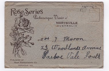 Marysville & District Historical Society
Photograph (item) - Black and white photographs, Rose Stereograph Company, Rose Series Picturesque Views of Marysville Australia, 1913-1967
A series of photographs produced by the Rose Stereograph Company in Victoria, Australia as a souvenir of Marysville.Souvenir envelope containing 12 black and white photographs of natural attractions in Marysville and surrounding area. Published by Rose Stereograph Co, Armadale, Victoria.Rose Series/ Picturesque Views of/ MARYSVILLE/ AUSTRALIA PUBLISHED BY/ ROSE STEREOGRAPH CO/ ARMADALE, VIC. Mrs. J Moron/ 23 Woodlands Avenue/ Pascoe Vale South The date stamp is illegible.the taggerty river marysville vic (image 1), panorama from mt gordon marysville vic (image 2), cora lynn falls marysville vic (image 3), cumberland-cora lynn trip marysville vic at the meeting of the waters (image 4), michael dene marysville vic (image 5), nichols lookout marysville vic (image 6), the stevenson river marysville vic (image 7), cathederal mount from mt gordon marysville vic (image 8), stevenson falls marysville vic (image 9), mountain ash tallest known hardwood tree in world (301ft 6in) cumberland marysville vic (image 10, the main street marysville vic (image 11), talbot drive vic no 12 taggerty river (image 12), rose stereograph company, souvenir, marysville, victoria -
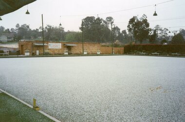 Ringwood and District Historical Society
Photograph, Ringwood Bowls Club- Hail storm at Bowls Club, Miles Avenue, 7th September 1955
Coloured photographLadies Section, Ringwood Bowls Club. 7th September, 1995. Play was called off due to a heavy downpour of hail stones which covered the greens at the Ringwood Bowls Club at Miles Avenue -
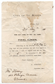 St Kilda Historical Society
Administrative record - Notice, Final Notice Dog Act, 1915
Final notice of payment required for dog registrationCream coloured paper printed in blackAnnotated by hand to show date of issue (30 August 1915); the date of the first notice (10 August); the fine (5 shillings); and the recipient of the notice (Mr Kerry, 46 Selwyn Avenue, Elwood)city of st kilda, dog registrations, 1890 dog act - victoria -
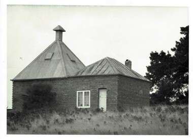 Phillip Island and District Historical Society Inc.
Photograph, Richardson's chicory kiln 1077-01
In 1878, the first chicory kiln was built by Mr. John and Solomon West, in Thompson Avenue, Cowes, near the Esplanade and the second kiln was built in 1880 by Mr Joseph Richardson.HistoricalLarge black & white photo of a brick chicory kiln with a metal roof,door and window. In a paddock with large trees nearby.2nd chicory kiln on Phillip Island, now turned into a holiday house.chicory, chicory kilns, joseph richardson, -
 Greensborough Historical Society
Photograph - Photograph - Digital Image, Marilyn Smith, Poulter Avenue power station, architectural features - Greensborough Railway Station 2021, 2021_02
Photographs of architectural features at Poulter Avenue power station at Greensborough Railway Station in February 2021, before the planned rebuild of the station as part of the Hurstbridge rail line upgrade. 5 Colour digital photographsgreensborough railway station, hurstbridge rail line upgrade, poulter avenue greensborough -
 Greensborough Historical Society
Article - Newspaper Clipping, Diamond Valley News, Centre on the move, 2006_06
An article from Diamond Valley News, discussing the move of Watsonia Occasional Child Care to larger premises. The service will move from Knight Street to Gabonia Avenue Watsonia.Newspaper clipping, Black text and colour image.watsonia occasional child care., knight street occasional child care centre, gabonia avenue watsonia