Showing 2818 items
matching wests road
-
 Ringwood and District Historical Society
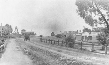
Photograph, Maroondah Highway Central, Ringwood. Main Street looking west from Warrandyte Road- 1908
... west from Warrandyte Road- 1908.... Street looking west from Warrandyte Road- 1908. Photograph ...Black and white photograph (2 copies)Written in lower right corner of photograph, "View near Railway Stn. Ringwood". Typed below one photograph: "Maroondah Hwy looking towards city with Warrandyte Rd coming in from right. Old Station Master's residence on left. Road had two levels here." Bank is E.S. & A. Agency. Bamford's Timber on right. Station Masters house on left. -
 Ringwood and District Historical Society
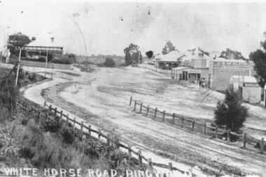
Photograph, Maroondah Highway Central, Ringwood. Whitehorse Road looking west. 1908
... Maroondah Highway Central, Ringwood. Whitehorse Road...: "Fence divides two levels of road opp Warrandyte Rd looking west ...Photographs (3 copies- 2 black and white, 1 sepia postcard).Typed below one photograph: "Maroondah Highway Ringwood looking west. Warrandyte Rd coming in from right. 1908." Written on back of another photograph: "Fence divides two levels of road opp Warrandyte Rd looking west. Station Master's house on left." -
 Ringwood and District Historical Society
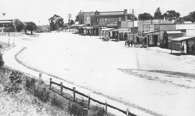
Photograph, Maroondah Highway Central, Ringwood. Whitehorse Rd. Ringwood looking west. 1918
Black and white photograph (3 copies- 2 large, 1 sepia postcard) Typed below one photograph: "Whitehorse Rd. Ringwood looking west - 1918" Image shows a variety of shops on left with a motor vehicle and a horse drawn cart out front. Station Master's house at top left. -
 Ringwood and District Historical Society
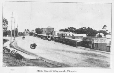
Photograph, Maroondah Highway Central, Ringwood. Main Street, looking west from Warrandyte Rd, c1924
Black and white photograph (2 copies- 1 large, 2 small) Typed below large photograph: "Main St looking west from Warrandyte Rd, c1924." Typed on back of one small photograph: "Coped from a circular for Mountain View Estate, J. Press, vendor, Second Av. Kew. In Mullum Rd, 90 yds from Oban Rd. Press, Rangeview & Mountview Avenues. Winnington just completed. 1924." -
 Ringwood and District Historical Society
Photographs, 1979-80 MMBW pipe line project at Hubbard Reserve, North Ringwood � First hole west of bore hole at 39 Burlock Avenue
Part of a 43-photo record of the MMBW�s engineering feat in drilling a 12 inch pipe line up to 40 feet deep through rock hardened by volcanic action associated with geological fault that occurs along the line. The work took place from October 1979 to May 1980 on the southern boundary of Hubbard Reserve, North Ringwood. The collection was presented to the Ringwood Historical Research Group by J Clarke on 9th June 1980.E561 N9 Feb 1980 A43 First hole west of bore hole at 39 Burlock Avenue -
 Ringwood and District Historical Society
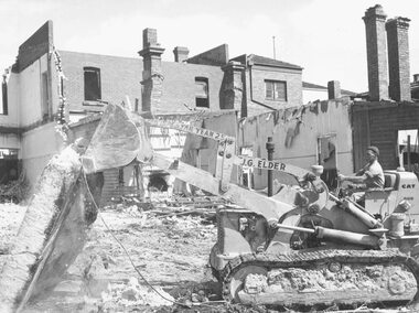
Photograph, Maroondah Highway Central, Ringwood. Demolition of Coffee Palace, Main St. 1966
Black and white photograph (2 copies- 1 large, 1 small)Typed below large photograph: "Demolition of Coffee Palace - Main St. 1966". Written on back of smaller duplicate photograph: "Demolishing Coffee Palace & shops cnr. Maroondah Hwy. & Adelaide St. (west cnr.) 1966. Portion of house on right - This was home of T. Grant, Blacksmith, 1883". -
 Ringwood and District Historical Society
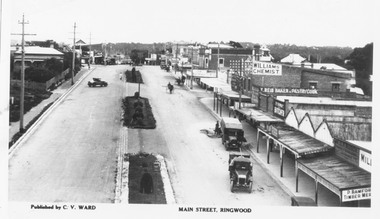
Photograph, Maroondah Highway Central, Ringwood. Main Street looking west from Warrandyte Road, 1928
... west from Warrandyte Road, 1928.... Street looking west from Warrandyte Road, 1928. Photograph ...Black and white photographTyped below photograph: "Published by C.V. Ward. Main Street, Ringwood". Written on rear of backing sheet- looking west from old Clocktower site. -
 Ringwood and District Historical Society
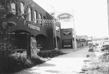
Photograph, Maroondah Highway West, Ringwood- 1978. 15 mile peg at Guest's Furniture Store
Black and white photographPhotograph shows Guest's Furniture Forum store, and also the original 15 mile cement marker. -
 Ringwood and District Historical Society
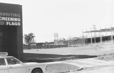
Photograph, Construction work at Target Square, NE corner of Maroondah Hwy and New Street, Ringwood - 1981, 1981
Two views of Target Square shopping complex building under construction.Written on back of photographs - V134a "29-6-81 View from Verstegen's no - New St across Brambles lot at the centre of Target building cnr of Charters-New St on right below Target." - V134b "30-6-81. Looking south from Brambles across Charter St. west end of Target. New St. just out of picture right". -
 Ringwood and District Historical Society
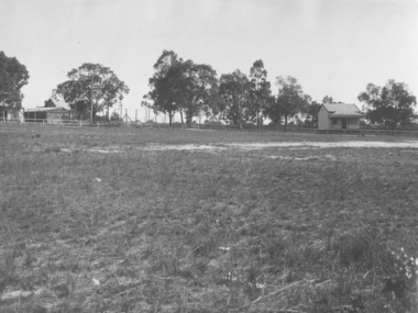
Photograph, Ringwood Oval, Ringwood Street - circa 1918, 1918
Ringwood Oval circa 1920, showing Ringwood Reserve grand stand, tennis courts on the left, and view towards Ringwood Street and Charter Street in the centre backgroun.. The school master's house behind courts was formerly in the Heatherdale Road school in 1885. It was moved in 1892. (See history of Ringwood State School No. 2997).Typed below photograph, "The old Ringwood Reserve grand stand. Tennis courts on the left, looking towards Ringwood and Charter St. in the centre background. ... 1920. (Site) later developed as Eastland carpark, south-west corner." -
 Ringwood and District Historical Society
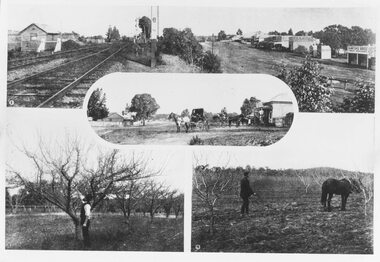
Photograph, Photos from a Weekly Times newspaper article featuring images of early Ringwood and East Ringwood circa 1910 (6 photos), Circa 1910
Shops, houses and hotel(s) were originally regarded as being in central Ringwood and later as Ringwood East after the commercial and residential developments gradually centered further west around the Railway Station precinct after train services commencedFive photographs; Ringwood Railway Crossing; Ringwood Shopping Strip; Pruning Demonstration; Shops, houses and hotel(s) in Mount Dandenong Road; Ploughing.Written on backing sheet, "Photos from Weekly Times. Check with H.A." -
 Ringwood and District Historical Society
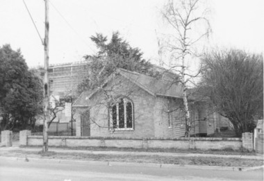
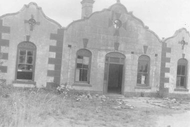
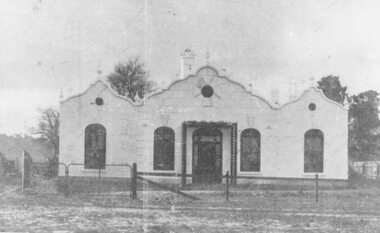
Photograph, The Gospel Church in Warrandyte Road, Ringwood in 1973, 1973
The Gospel Church in Warrandyte Road in 1973, with Eastland being extended in backgroundWritten on back of photograph, "Gospel Hall, W'dyte Rd. west side, 40 yards south of Miles Ave. 11.7.73" -
 Ringwood and District Historical Society
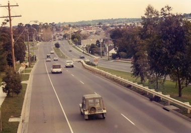
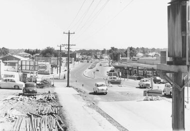
Photographs, Maroondah Highway, Ringwood near Wingrove Place looking west circa 1980s
Maroondah Hwy near Wingrove Place. (EB carriageway); looking West; Ringwood City circa 1980s -
 Ringwood and District Historical Society
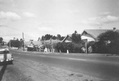
Photograph, Bedford Road,Ringwood East, looking west from outside No.128. (House far left is No.126) - 1/9/74
... Bedford Road,Ringwood East, looking west from outside No... Road Ringwood North melbourne Written on back of photograph ...Written on back of photograph, "Bedford Rd. looking west from outside No.128. (House far left is No.126 as in brochure. 1/9/74)" -
 Ringwood and District Historical Society
Photograph, Maroondah Highway West, Ringwood. The "Rest" tea rooms, Maroondah Highway, opposite Heatherdale Road (now demolished) (undated)
Black and white photograph (2 images)Label attached to photograph reads, "Old house on north side of Maroondah Highway near Range View Road. Built during 1800s - now demolished". -
 Ringwood and District Historical Society
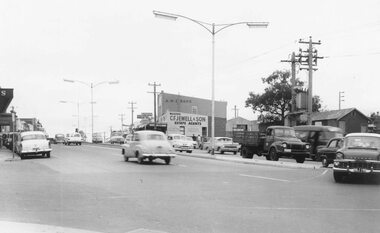
Photograph, Maroondah Highway West, Ringwood- 1963
Black and white photograph. (2 images)Written on back of photograph MHW84b, "Photo showing parking congestion in the Ringwood shopping centre". Stamped on back of photograph, "Edwin G. Adamson, A.R.P.S. ... May 1963". -
 Ringwood and District Historical Society
Photograph, Maroondah Highway West, Ringwood- 1960
Black and white photographWritten on back of photograph: "Maroondah Highway from cool store site - looking west, 1960". -
 Ringwood and District Historical Society
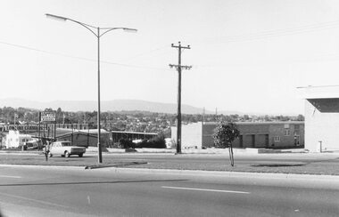
Photograph, Maroondah Highway West, Ringwood- 1969. Looking east from Heatherdale Road
Black and white photographWritten on back of photograph: "May, 1969" -
 Ringwood and District Historical Society
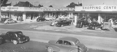
Photograph, Maroondah Highway West, Ringwood- 1954.The Ringwood Shopping Centre
Black and white photographWritten on back of photograph: "Mail 15 July 1954". -
 Ringwood and District Historical Society
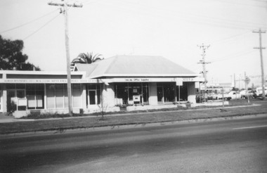
Photograph, Maroondah Highway West, Ringwood- 1969. Old Coach and Horses Hotel site
Black and white photographWritten on back of photograph: "May 1969. Old Coach and Horses Hotel altered to this". -
 Ringwood and District Historical Society
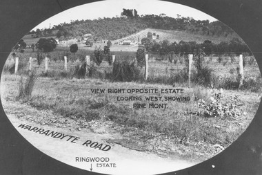
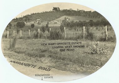
Photograph, View from Warrandyte Road opposite Ringwood Estate looking west, showing Pine Mont. (no date)
Printed onto photograph, "View right opposite estate looking west, showing Pine Mont". Roadway identified as "Warrandyte Road" and "Ringwood Estate" printed at bottom of picture. -
 Ringwood and District Historical Society
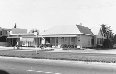
Photograph, 'The Rest' tea rooms at west entrance to Ringwood c1900s-1950
Written on back of photograph, "Top of hill at west entrance to Rwd. 1900s - 1950. 1950 pulled down - Eastland." -
 Ringwood and District Historical Society
Photograph, Ringwood from Loughnans Road, 1960. Round house being built. Looking slightly west
... . Looking slightly west". Ringwood from Loughnans Road, 1960. Round ...Written on back of photographs, "Ringwood from Loughnans Road, 1960. Round house being built. Looking slightly west". -
 Ringwood and District Historical Society
Photograph, Promotional photograph - View opposite Ringwood Estate, Warrandyte Road, looking west towards Pine Mont. (no date)
... , Warrandyte Road, looking west towards Pine Mont. (no date)... Road Ringwood North melbourne Printing on photograph reads ...Printing on photograph reads, "View right opposite estate looking west, showing Pine Mont. Warrandyte Road". Catalogue card reads, "Pinemont Estate (Loughnan's Hill). Right opposite estate looking west." -
 Ringwood and District Historical Society
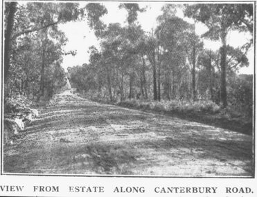
Photograph, Coleman's Heathmont Estate Sale, 15/12/1923. Looking west along Canterbury Road Heathmont. Railway bridge is situated at foot of hill
... Coleman's Heathmont Estate Sale, 15/12/1923. Looking west.../12/1923. Looking west along Canterbury Road Heathmont ...Printing below photograph reads, "View from estate along Canterbury Road." Typed on backing sheet below, "Canterbury Rd. Heathmont looking towards city. Railway bridge at foot of hill 1923. Area in foreground now shopping centre both sides of road." -
 Ringwood and District Historical Society
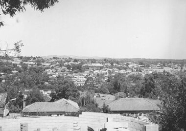
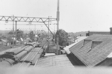
Photograph, Ringwood railway station precinct. View from pedestrian overpass looking west towards Melbourne c.1948
Accompanying typed sheet reads, "...shows the Croydon train in the north platform ready with signal off to leave for Melbourne". -
 Ringwood and District Historical Society
Photograph, Canterbury Rd. Heathmont looking west from railway bridge. 1973
Catalogue card reads, "Canterbury Rd. Heathmont looking west from railway bridge." -
 Ringwood and District Historical Society
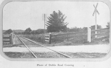
Photograph, Dublin Rd. railway crossing, East Ringwood, looking west - 1923 (2 images)
Typed below photograph, "Dublin Rd. railway crossing, East Ringwood, looking west - 1923". (2 copies). -
 Ringwood and District Historical Society
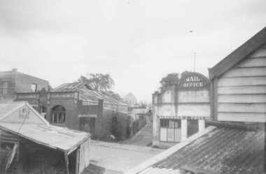
Photograph, Former Ringwood Mail office, Adelaide Street, 1955 looking along laneway to west showing Ham's Billiard Saloon to left, 1955
This laneway which ran between Bamford's Timber Yard on the corner of Warrandyte Rd and Maroondah Hwy became Civic Place. Two storey building is Renong Chambers. Bottom left shows Jack Orr's clothes hoists. Bottom right is Horman & Woolhouse plumbers. This area was demolished in 1965.Typed below photograph, "Former Ringwood Mail office, Adelaide Street, 1955". Catalogue card reads, "Adelaide St. looking along laneway to west showing former "Mail" office and Billiards Pool to left, 1955." Written on backing sheet of one copy, "Lane between Bamford's Timber Yard, corner Warrandyte Rd. and Maroondah Highway. House demolished 1965. 'Ringwood Mail' office at end of lane in Adelaide St." Another copy's backing sheet reads, "Mail Office. Lane went to Melbourne St. Ham's Billiard Saloon, Renong Chambers (2 storey) bot. left Jack Orr's clothes hoists. Bot. right Horman & Woolhouse plumbers." Another copy reads, "This laneway became Civic Place." -
 Ringwood and District Historical Society
Photograph, Maroondah Highway West, Ringwood- 1969. Whitehorse Rd businesses at former Coach and Horses Hotel
Black and white photographNil