Showing 173684 items
matching street
-
 Warrnambool and District Historical Society Inc.
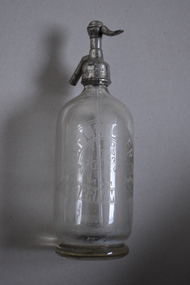
Soda Syphon, Fletcher, c 1930 (contents of syphon)
This soda syphon is a device for dispensing carbonated or soda water. The valve allows portion of the contents to be dispensed whilst maintaining the pressure inside to keep the rest of the contents from going flat. The bottle is marked ‘J. Fletcher’. John Fletcher worked as a boy at Rowley’s cordial factory in Banyan Street, Warrnambool. He then worked for John Davis who had established the Union Cordial Factory in Koroit Street, Warrnambool in the 1860s. In 1885 John Fletcher bought the Davis business and operated it until 1930. John Fletcher sold the business to Ralph Reeves and as Reeves initially used Fletcher bottles and syphons, the contents of the bottle could have come from the time of either John Fletcher or Ralph Reeves. This syphon is of interest as it comes from a mid 20th century cordial factory in Warrnambool. Cordial manufacturing was an important industry in Warrnambool for over 100 years. This is a clear glass soda syphon with a round sold base and a rounded body and a metal pump and valve mechanism affixed to the top opening. A glass tube is inside the bottle and is part of the pump mechanism. The top metal section is very corroded. The side of the bottle has the Fletcher trademark - the stylized letters J and F. ‘J. Fletcher Trade Mark Warrnambool’ ‘J. Fletcher’ ‘British Syphon Mfg Co. Ltd London’ cordial manufacturing in warrnambool, fletcher, history of warrnambool -
 Warrnambool and District Historical Society Inc.
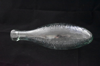
Bottle, D Mc Sweeney, Late 19th century
This torpedo glass bottle comes from the Warrnambool aerated waters business of Daniel McSweeney. It would have held a type of soda and the bottle was made so that it could not stand up and so the soda was kept in contact with the cork. This stopped the cork from shrinking and so the pressure was not lost. Daniel McSweeney opened a cordial factory in Fairy Street in 1885 and, by the early 1890s had transferred his business to Henna Street. This factory was advertised as the largest cordial factory in the Western District, though this appeared to refer to the size of the building. In the late 1890s James Trigg leased the factory from McSweeney for some time. The factory was closed in 1900 but the building remains today and is occupied by the Alderdice Brass FoundryThis bottle is of interest as one of few bottles we have that came from the Warrnambool cordial factory of Daniel McSweeney. He was a prominent maker of soft drinks in the late 19th century.This is a green glass bottle. It is a ‘torpedo’ bottle so it is of a spherical shape with a pointed curved end, a rounded neck and a round moulded top. There is no stopper. The name of the manufacturer of the soft drink contents is embedded into the glass on one side. ‘D.McSweeney Warrnambool’ daniel mcsweeney warrnambool, cordial manufacturers in warrnambool, history of warrnambool -
 Glen Eira Historical Society
Article - Long Street, 21, Elsternwick
Three print advertisements for 21 Long Street, Elsternwick. (1) Dated 01/12/2004, source unknown, very briefly describes the house and its features and includes a copy of a photograph of the house. (2) The second, a feature in Melbourne Weekly Bayside, dated 5 - 11/07/2006, unattributed, describes the recent renovation of the Victorian Style house now named “Rosealea”, and details its architectural features. It includes copies of four photographs of the house. (3) The third advertisement, in Melbourne Weekly Bayside dated 21/09/2011, lists the architectural features of 21 Long Street, Elsternwick, and provides details of the auction and agent. Includes three photographs within the advertisement.elsternwick, advertisements, roger mark, long street, rosealea, stefanis angelos, auctions, architectural features, stavrakis bill, land sales, glenhuntly road, melbourne weekly bayside, victorian style, nardella paul, buxton, biggin scott, real estate agents, real estate agencies, lead lights, builders, construction (events and activities), cast iron work -
 Mordialloc College Alumni Association Inc (MCAA)
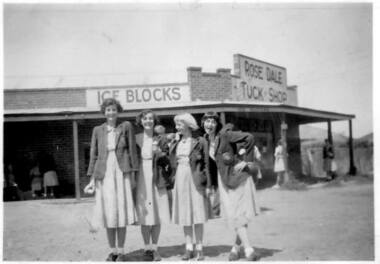
Photograph, 1953 Tuck Shop opposite Mordialloc-Chelsea High School, 1953
Four Mordialloc-Chelsea High School students outside the school Tuck Shop on the corner of Attenborough Road and Station Street Aspendale. The shop was located across from the school and run by Mr Gustav Fahnert and his family. Mrs Rubina Fahnert nee Brown was the daughter of Thomas Brown who was a son of Hugh Brown, the pioneer market gardener of the Aspendale/Mordialloc area. The Brown's house still remains on the second block from the corner of Station Street and Attenborough Road (as of February 2018). Students from left to right are Joan Collins, Barbara Fox, Joan Connor, Joan Rees. Photographer: Heather Donovan nee Padman. Photo courtesy Heather Donovan.Black and white photograph. -
 Marysville & District Historical Society
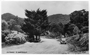
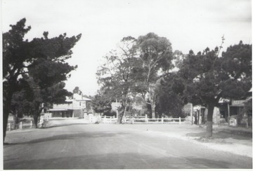
Postcard (item) - Black and white postcard, Valentine Publishing Co. Pty. Ltd, Entrance to Marysville V.11, 1923-1963
A digital copy of an early black and white photograph of the Marysville-Wood's Point Road at the corner with Murchison Street in Marysville in Victoria.A digital copy of an early black and white photograph of the Marysville-Wood's Point Road at the corner with Murchison Street in Marysville in Victoria. This postcard was published by the Valentine Publishing Co. Pty. Ltd. as a souvenir of Marysville.marysville, victoria, postcard, valentine publishing co, souvenir, murchison street, marysville-wood's point road -
 Federation University Historical Collection
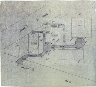
Plan, Plan for a Service Plan at the Ballarat School of Mines
This plan appears to show buildings that were not built. Plkan showing the section of the Federation University SMB Campus between Grant Street and Lydiard Street, near Armstrong Street South.smb campus, ballarat school of mines, grant street, lydiard street, former ballarat supreme court -
 Bendigo Historical Society Inc.
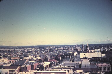
Slide - BENDIGO & EASTER FAIR, 1963
View from Rosalind Park tower looking south across View street and Forest Street, church in Forest Street in slide.slide, bendigo, city view -
Port Melbourne Historical & Preservation Society
Photograph - Outline of demolished house (139 Station Street), 137 Station Street, Port Melbourne, Peter Libbis, 6 May 1998
Taken by Peter Libbis between demolition and rebuilding of 139One of four photos of 137 Station Street, showing outline of wall of demolished 139 Station Street (corner of Spring Street)demolitions -
Port Melbourne Historical & Preservation Society
Document - Specification, Metalling and chanelling, Clark Street from Graham Street to Poolman Street, Engineering Department, Town of Port Melbourne, 14 Mar 1893
Specification for metalling channelling Clark Street from Graham Street to Poolman Street Loan Works 1893; relates to plan 96.2Signed by JJ Bartlett (Mayor)engineering - roads streets lanes and footpaths, arthur victor heath, town clerks, james john bartlett, mayors -
Port Melbourne Historical & Preservation Society
Plan - Metalling and channelling Clark Street from Graham Street to Poolman Street, Engineering Department, Town of Port Melbourne, 14 Mar 1893
Plan for metalling channelling Clark Street from Graham Street to Poolman Street Loan Works 1893; relates to specification 96.1Signed by JJ Bartlett (Mayor)engineering - roads streets lanes and footpaths, arthur victor heath, town clerks, james john bartlett, mayors -
Port Melbourne Historical & Preservation Society
Document - Specification, Pool Street from Nott Street to Princes Street, Engineering Department, Town of Port Melbourne, 14 Mar 1893
Plan for Pool Street from Nott Street to Princes Street Loan Works 1893 plan 18; relates to plan 97.2Signed by JJ Bartlett (Mayor) 14.3.1893engineering - roads streets lanes and footpaths, town planning, town clerks, mayors, arthur victor heath, james john bartlett -
Port Melbourne Historical & Preservation Society
Plan - Pool Street from Nott Street to Princes Street, Engineering Department, Town of Port Melbourne, 14 Mar 1893
Plan for Pool Street from Nott Street to Princes Street Loan Works 1893 plan 18; relates to specification 97.1Signed by JJ Bartlett (Mayor) 14.3.1893engineering - roads streets lanes and footpaths, town planning, town clerks, mayors, arthur victor heath, james john bartlett -
 Kew Historical Society Inc
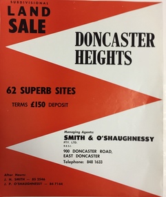
Plan - Subdivision Plan, Doncaster Heights
Real estate brochure produced for Smith & O'Shaughnessy of 900 Doncaster Road for the sale of the '65 superb sites' in the Doncaster Heights Estate. Streets with lots for sale include: Church Road, Norfolk Circuit, and Hampshire Road.Historic subdivision planFour-page colour real estate brochure issued for the sale of the Doncaster Heights Estate. The inside pages include a street plan with the numbered lots.subdivision plans - doncaster, doncaster heights estate -
 Kew Historical Society Inc
Plan, Melbourne & Metropolitan Board of Works : Borough of Kew : Detail Plan No.1564, 1905
The Melbourne and Metropolitan Board of Works (MMBW) plans were produced from the 1890s to the 1950s. They were crucial to the design and development of Melbourne's sewerage and drainage system. The plans, at a scale of 40 feet to 1 inch (1:480), provide a detailed historical record of Melbourne streetscapes and environmental features. Each plan covers one or two street blocks (roughly six streets), showing details of buildings, including garden layouts and ownership boundaries, and features such as laneways, drains, bridges, parks, municipal boundaries and other prominent landmarks as they existed at the time each plan was produced. (Source: State Library of Victoria)This plan forms part of a large group of MMBW plans and maps that was donated to the Society by the Mr Poulter, City Engineer of the City of Kew in 1989. Within this collection, thirty-five hand-coloured plans, backed with linen, are of statewide significance as they include annotations that provide details of construction materials used in buildings in the first decade of the 20th century as well as additional information about land ownership and usage. The copies in the Public Record Office Victoria and the State Library of Victoria are monochrome versions which do not denote building materials so that the maps in this collection are invaluable and unique tools for researchers and heritage consultants. A number of the plans are not held in the collection of the State Library of Victoria so they have the additional attribute of rarity.Original survey plan, issued by the MMBW to a contractor with responsibility for constructing sewers in the area identified on the plan within the Borough of Kew. The plan was at some stage hand-coloured, possibly by the contractor, but more likely by officers working in the Engineering Department of the Borough and later Town, then City of Kew. The hand-coloured sections of buildings on the plan were used to denote masonry or brick constructions (pink), weatherboard constructions (yellow), and public buildings (grey). In 1905, when Plan No.1564 was printed, that part of Kew bordered by Brougham Place (now Daniell Place), Mount Street, Sackville Street and Ross Street was already the location of a number of large mansions. Here, subdivisions, at least at this stage, produced larger blocks than in Central Kew. Many of the houses on this plan are named: ‘Faybrook’, ‘Northumbria’, ‘Parkholm[e]’, ‘Dunboe’, ‘Katoomba’ and ‘Eschol’ fronting Sackville Street. Eschol was once the home of the manufacturer Robert Harrison, whose cordial factory in Spring and Argyle Streets Fitzroy are noted on the Victorian Heritage Register. ‘The Hawthorns’ on the corner of Brougham Place and Mount Street was the home of the medical practitioner Frank William Fay, who won the military cross and other honours for conspicuous gallantry and devotion to duty in World War 1.melbourne and metropolitan board of works, detail plans, mmbw 1564, cartography -
 Kew Historical Society Inc
Plan, Melbourne & Metropolitan Board of Works : Borough of Kew : Detail Plan No.1572, 1905
The Melbourne and Metropolitan Board of Works (MMBW) plans were produced from the 1890s to the 1950s. They were crucial to the design and development of Melbourne's sewerage and drainage system. The plans, at a scale of 40 feet to 1 inch (1:480), provide a detailed historical record of Melbourne streetscapes and environmental features. Each plan covers one or two street blocks (roughly six streets), showing details of buildings, including garden layouts and ownership boundaries, and features such as laneways, drains, bridges, parks, municipal boundaries and other prominent landmarks as they existed at the time each plan was produced. (Source: State Library of Victoria)This plan forms part of a large group of MMBW plans and maps that was donated to the Society by the Mr Poulter, City Engineer of the City of Kew in 1989. Within this collection, thirty-five hand-coloured plans, backed with linen, are of statewide significance as they include annotations that provide details of construction materials used in buildings in the first decade of the 20th century as well as additional information about land ownership and usage. The copies in the Public Record Office Victoria and the State Library of Victoria are monochrome versions which do not denote building materials so that the maps in this collection are invaluable and unique tools for researchers and heritage consultants. A number of the plans are not held in the collection of the State Library of Victoria so they have the additional attribute of rarity.Original survey plan, issued by the MMBW to a contractor with responsibility for constructing sewers in the area identified on the plan within the Borough of Kew. The plan was at some stage hand-coloured, possibly by the contractor, but more likely by officers working in the Engineering Department of the Borough and later Town, then City of Kew. The hand-coloured sections of buildings on the plan were used to denote masonry or brick constructions (pink), weatherboard constructions (yellow), and public buildings (grey). Plan No. 1572 represents the built environment bordered by Barkers Road, Wrixon Street, Edgevale Road and Fitzwilliam Street. Other streets identified on the plan include Stansell Street. Plan 1572 shows that by 1903-05, there was only patchy development in this area of Kew, mainly on Edgevale Road and Fitzwilliam Street. Only two named houses are identified: the quaintly named ‘Tweed Cottage’, and ‘Mendip’. The earliest reference to Treed Cottage in Australian newspapers is to the death of Walter Thompson, aged 74 who was a resident there in 1885. His youngest daughter was to die there in 1908. Mendip to the north of Tweed Cottage was owned by Henry Thompson; he was to die in 1901; his wife in 1932. At this period of time, Malin Street and Clivedon Court did not extend to Barkers Road.melbourne and metropolitan board of works, detail plans, mmbw 1572, cartography -
 The Beechworth Burke Museum
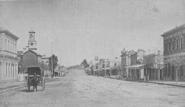
Photograph, 1875
This photograph was taken in the winter of 1875 from the Telegraph Station looking up Ford Street towards the Church of England. Picture is a horse and wagon walking towards the camera. Black and white rectangular postcard. The image is printed on matt photographic paper and mounted on cardboard. This photograph depicts Ford Street looking south C 1875 in Beechworth.Obverse: NO INSCRIPTION Reverse: 5570 35 Beechworth about 1875 American & Australian Photographic Company. Victoria Branch. C. BAYLISS, Manager No. 61 Extra Copies may be had by sending Number to present Address. beechworth, ford street, 1875, horse, wagon, horse and wagon, church of england, burke museum, winter -
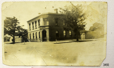 Flagstaff Hill Maritime Museum and Village
Photograph - Building, Bank of Australasia Warrnambool, ca. 1860
This sepia coloured photograph show the image of the former Bank of Australasia in Warrnambool. The two-storey building was built for the bank on the corner of Timor and Kepler Streets and opened there for business in 1860. It is now one of the City's Historic Buildings. The Bank of Australasia was incorporated by Royal Charter of England in March 1834. It came to Australia on 14th December 1835, opening in Sydney. The Acting Superintendent of the Bank of Australasia in Sydney at that time was David Charters McArthur. He was Superintendent from 1867-to 1876. The Melbourne branch of the Bank of Australasia opened on 28th August 1838 in a two-roomed brick cottage on the north side of Little Collins Street. Two huge mastiff dogs were kept in the backyard and let loose at night to guard the bank. The government also provided an armed military sentinel. Due to the bank's rapid growth, a new building for the Melbourne branch was opened in 1840 at 75 Collins Street West. By 1879 the bank had been upgraded to a magnificent two-storey building on the corners of Collins and Queens Streets, with the entry on Collins Street. In 1951 the Bank of Australasia amalgamated with the Union Bank to form the Australia and New Zealand Bank, now known as the ANZ. Then in 1970, the ANZ merged with both the ES&A and the London Bank of Australia to form the ANZ Banking Group Limited. The ANZ Banking Group Ltd kindly donated a variety of historic items from the Bank of Australasia. BANK of AUSTRALASIA, WARRNAMBOOL – In 1854 Warrnambool had two banks, the Union Back and the Bank of Australasia. Later, completely different bank businesses opened; in 1867 the National Bank of Australasia, then in 1875 the Colonial Bank of Australasia. The original Warrnambool branch of the Bank of Australasia was established in July 1854, and operated from a leased cottage on Merri Street, close to Liebig Street. The bank later bought a stone building previously erected by drapers Cramond & Dickson on the corner of Timor and Gibson Streets. Samuel Hannaford was a teller and then Manager at the Warrnambool branch from 1855 to 1856 and the Warrnambool Council chose that bank for its dealings during 1856-57. In 1859 Roberts & Co. was awarded the contract to build the new Bank of Australasia branch for the sum of £3,000. The land was on a sand hill on the northeast corner of Timor and Kepler Streets and had been bought in 1855 from investor James Cust. The new building opened on May 21, 1860. The bank continued to operate there until 1951 when it merged with the Union Bank to form the ANZ Bank, which continued operating from its Liebig Street building. Warrnambool City Council purchased the former Bank of Australasia building in 1971 and renovated it, then on 3rd December 1973 it was officially opened as the Art Gallery by Cr. Harold Stephenson and Gallery Director John Welsh. The Gallery transferred to the purpose-built building in Liebig Street in 1986 and the old bank building is now the Gallery club. Staff at the Bank of Australasia in Warrnambool included the following men but others were also involved: Samuel Hannaford, Teller then Manager from 1855-1856; W H Palmer, Manager from January 1857 until November 1869 when the Teller Basil Spence was promoted to Manager; H B Chomley, Manager from April 1873 and still there in 1886; A Butt, Manager in 1895-1904; J R McCleary Accountant and Acting Manager for 12 months, until 1900; A Kirk, Manager 1904; J Moore, staff until his transfer to Bendigo in December 1908; J S Bath was Manager until 1915; C C Cox, Manager until April 1923; Richard C Stanley, Manager 1923 to April 1928. The photograph is significant historically for its connection with the Bank of Australasia. The early Australian bank was established in 1834 by Royal Charter and opened in Sydney, Australia, in Sydney in 1835. The bank had many Australian offices in November 1877, particularly on the east and south coasts. Victoria had 45 percent of all Offices. The photograph has local historical significance for its association with the Warrnambool Bank of Australasia, which was established early in Warrnambool's history. It was Warrnambool Council’s first bank. The bank continued to operate until the organisation's merger in 1951 when it became the ANZ Bank Group of today. The Bank was an integral part of the growth of local commerce and the community.Black and white (or sepia) rectangular photograph, landscape orientation. Image of a two-storey building on a street corner. It is the former Bank of Australasia, Warrnambool, on the corner of Timor and Kepler Streets that was built in 1860. The reverse has a round, serrated-edged red label with an inscription, covered in opaque tape, plus four lines of handwritten text. There are several pin holes through the photograph.Label with: "AH2 2 / W.BOOL" Writing in pen: "D. K. Frew / --- / ---- / ----"flagstaff hill, warrnambool, shipwrecked coast, flagstaff hill maritime museum, maritime museum, shipwreck coast, flagstaff hill maritime village, great ocean road, bank of australasia, boa, union bank, australia & new zealand bank, anz bank, david charters mcarthur, d c mcarthur, commerce, banking, samuel hannaford, w h palmer, basil spence, h b chomley, a butt, j r mccleary, a kirk, j moore, j s bath, c c cox, richard c stanley, historic building, roberts & co., james cust, bank of australasia warrnambool -
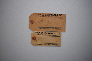 Warrnambool and District Historical Society Inc.
Labels x 2, Evans & Co, Early 20th century
The saddler and harness business of E.D. Evans and Co. in Liebig Street was prominent in Warrnambool from the 1870s to the early decades of the 20th century. Edward Evans came to Warrnambool in the 1850s, was a Warrnambool Councillor from 1875 to 1878 and from 1884 to 1888 and was prominent in racing circles in the town,These labels are of interest as E.D. Evans was a well known saddle and harness maker in Warrnambool's history..1 Light brown cardboard label, primarily rectangular with mitred corners at one end, a hole with a red reinforce sticker surrounding it. The label has black printed text and several parallel lines. Also there is a pencilled code. .2 Identical to .1 but smaller.1 FROM E. D. EVANS & CO. SADDLE & HARNESS MAKERS, WARRNAMBBO, PORT FAIRY, AND TERANG. C 1900 ( In pencil) .2 Identical to .1 edward evans, saddler, warrnambool councillor, warrnambool racing -
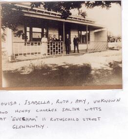 Glen Eira Historical Society
Document - Evesham Ladies’ Primary School
Materials relating to Evesham Ladies’ Primary School, 11 Rothschild Street, Glen Huntly, including: a promotional flier (177mm x 224mm) a photograph of the Watts family standing in front of the school with accompanying envelope (90mm x 127mm) A hand-written note about the familyelsternwick martin street haselor, watts ruth, elsternwick, evesham ladies’ primary school, watts thomas, glen huntly rothschild street 11, watts louisa isabella, kavanagh mrs, phillips w. a. rev., watts isabella, nash mrs, clarke a. e. mrs., watts amy, glen huntly, howden mrs., watson – gray miss, glen huntly heather brae, glen huntly bealiba, watts henry charles salter, independent schools, schools, primary schools -
Glen Eira Historical Society
Document - Morey Family
Two items of official documents for the Morey family: 1.Photocopy of Mrs Jean Monk’s baptismal certificate, St. Peter’s Church Murrumbeena. 2.Photocopy of certificate of Title to 21 Margaret Street, Murrumbeena. Has subsequent owners, other than the Morey family on documentrobertson stella jean, st. peter’s church, murrumbeena, caulfield, morey elizabeth ann, blair john arthur clerke, certificates, dutton edmund, dutton phyllis, atkinson bernard allan, buhler stella martha, holywood grove, newell frank jamesbornstein zelman, b.m. terry and staff pty ltd, zygier ted, zygier lea lucia, edinburgh avenue, beresford street -
Glen Eira Historical Society
Article - Long Street, 3, Elsternwick
A real estate advertisement dated 23/09/2005, source unknown regarding the sale of 3 Long Street, Elsternwick. The advertisement listed by The Moore Company real estate agency includes a description of the house and copies of three colour photographs, one of the exterior and tow of the interior.elsternwick, long street, advertisements, victorian style, land sales, houses -
Glen Eira Historical Society
Document - Liscard St, 9, Elsternwick
A typed copy of a one-page report dated 16 May 1988 by H. Bullock and Rosalind Landells of Brighton Historical Society regarding the history and occupany of 9 Liscard Street, Elsternwick from 1888-1974. An undated hand-written note of the same information is included.liscard street, glen eira road, elsternwick, doyle estelle mrs, trew william tracey, cobbledick f.j. mrs, larsen rasmur j., johnson e. mrs, larsen bertha mrs, larsen roy, corkhill, depression 1890s -
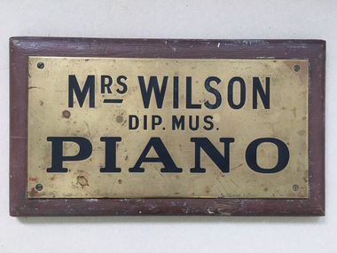 Warrnambool and District Historical Society Inc.
Name Plate, Mrs Wilson Piano, C mid 20th Century
We have limited information on Mrs Wilson, piano teacher except that a Mrs A Wilson operated from Merri Street in 1904. Plaques such as these were hung outside premises to denote where people could access services and were often used by professional people and services. A link to one of Warrnambool's early music teachers.Small brass plate screwed to brown painted wooden board. Rectangular. Metal is stamped with name and details and filled in black.Mrs Wilson Dip Mus Piano. Rennie and Dodds 92 Little Collins St stamped on R H bottom corner . gauranteed filling stamped on lower left edge.warrnambool, mrs wilson piano teacher, mrs wilson pianoforte teacher, warrnambool pianoforte teachers 1904 -
 Sunbury Family History and Heritage Society Inc.
Photograph, Rosa McCall, Old Broadmeadows Township, 1949
The former Old Broadmeadows township in the photograph was taken in 1949. The hotel is the two storey building in the middle distance and the former general store is partly hidden by trees on the RHS. The image is looking to the north in Fawkner Street, across the Moonee Ponds Creek. The township is now part of Westmeadows.Old Broadmeadows Township was an important stopping-off point for travellers on their way to Sydney on the Old Sydney Road, (now Mickleham Road) up until 1869 when Sydney Road was finally opened. A print of a non-digital black and white photograph of a small country township with a shop on the RHS and a two storey building in the middle distance. Pine trees are growing on either side of the roadway.old broadmeadows township, townships, moonee ponds creek, westmeadows -
 Bendigo Historical Society Inc.
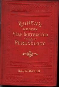
Book - COHEN'S MODERN SELF INSTRUCTOR IN PHRENOLOGY
271 page hardcover titled 'The Modern Self Instructor in Phrenology, Physiognomy and physiology or The Peoples Hand book of Human Nature. Red in colour with gold print.The first page is yellow paper which has a hand written note in black ink which reads: 'Presented to Henry Gough by his teacher A. Hampson for obtaining the highest number of marks during 1887 in his class at St. Paul's Sunday School dated 1/04/88. The book is Cohen's view into the mind, body, and sole of human beings.Gustavus Cohen. George Whitehead & Sons, Printers, New Street & Kings Street, Huddersfield.medicine, mental health, phrenology, henry gough, a. hampton -
Port Melbourne Historical & Preservation Society
Photograph - Four men outside a house, Station Street, Port Melbourne, 1800s
Photographic copy of a photograph of a house in Station Street with four men in front. All wear shirts and hats, three wear jackets, two of these have ties, the other a scarf. The coatless man appears to have a corncob pipe in his mouth. These men are related to the Smith family, one of them being the house owner who is married to a Smith girl. Large tree visible on left, and a tree behind the distinctive picket fence. Date is unknown; probably 1800s.Photo has been mounted, velcoo's and marked in felt pen 'copy of photo belonging to Margaret Couch, Princes Street'.built environment - domestic, families, margaret smith couch -
 Marysville & District Historical Society
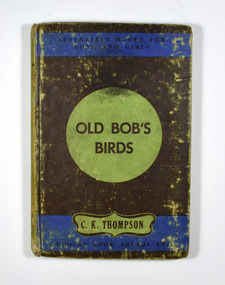
Book, Charles Kenneth Thompson, Old Bob's Birds, 1950
This is a delightful book that will appeal to children of all ages, and especially those of the tenderer years. Old Bob the sundowner is a character who will endear himself to young readers. So will his two small friends, Roddy and Susan, to whom he imparts all the vast lore of the bush he has gained during a lifetime of wandering.There is no dust cover. Front cover shows the series name, the title of the book, the author's name and the publisher's name.fictionThis is a delightful book that will appeal to children of all ages, and especially those of the tenderer years. Old Bob the sundowner is a character who will endear himself to young readers. So will his two small friends, Roddy and Susan, to whom he imparts all the vast lore of the bush he has gained during a lifetime of wandering.australia, nature, birds, c.k. thompson, fiction, old bob