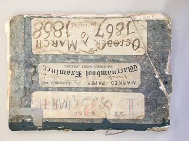
Showing 25493 items matching "no.8"
-
 Bacchus Marsh & District Historical Society
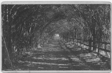
Photograph, Osage Orange Avenue Taverner Street Bacchus Marsh
A.C. (Arthur Charles) Simon a pioneer orchardist in the Bacchus Marsh district planted this avenue of Osage orange trees in about 1883, creating an imposing entrance to his property from Taverner Street. Simon also believed that the trees on his orchard property would provide a protective shelter for his other plants. Osage orange trees (Maclura pomifera) are a small deciduous tree or large shrub, native to the south-central United States. It usually grows to about 8 to 15 metres high. The distinctive fruit, a multiple fruit that resembles an immature orange, is roughly spherical in shape, about 8 to 15 centimetres in diameter, and turns bright yellow-green in the autumn. A. C. Simon is believed to have imported the Osage orange seeds from America around the 1860s and later used them to plant the trees depicted in this image. The date of this image is not certain but it probably shows the trees around the 1900s or 1910s. The avenue of trees was known for many years in Bacchus Mars as 'Simons Avenue', and were featured in a Rose series postcard dating from around 1900-1920. The remnants of this avenue or grove of trees can be seen on some of the properties on the north side of Taverner Street Bacchus Marsh and along the Werribee River west of the FIsken Street bridge.The Bacchus Marsh Heritage Study of 1995 described the Osage Orange Tree avenue as being of regional historical significance as a landscaping practice, pioneering of its type, It was also described as of local significance as a well-known landmark due to it be being represented on widely distributed post cards which depicted scenes of Bacchus Marsh in the early part of the twentieth century. This early photographic image is evidence of this social and cultural significance.A black and white photograph print mounted on mounting board showing an avenue of Osage orange trees. trees, osage orange trees, simon family bacchus marsh, arthur charles simon 1833-1924, orchardists -
 Wangaratta RSL Sub Branch
Badge - RASB- Active Service, C1945
The Returned from Active Service Badge (RASB) is a military badge and awarded to John Nelson Taylor QX25010;2900269;3108420 who served with the AIF 19/1/41-7/12/1945;Regular Army Special Reserve 30/1/1952-29/1/1955 and CMF 1/8/1959-2/1/1960. John was posted to 2/7 Advanced Workshops and saw active service in New Guinea. He again saw active service with the 2 Battalion Royal Australian Regiment in Japan and Korea including action at the Battle of the Hook. He joined the CMF and served with the 8/14 Victorian Mounted Rifles until final discharge on 2/1/1960. He was awarded the 1939-45 Star,Pacific Medal,War Medal 1939-45,Australian Service Medal 1939-45,Australian Active Service Medal 1945-75 with clasp Korea,Korea Medal,United Nations Service Medal (Korea),Australian Service Medal 1945-75 with clasps PNG and Korea,Australian Defence Medal and Returned from Active Service Badge. John was an active member of the Wangaratta RSL Sub Branch, served on the Committee and received a 50 year certificate of service to the RSL. He passed away in January 2021.The Returned from Active Service Badge (RASB) is issued to Australian Defence Force personnel who have rendered warlike service. The badge enables individuals to display their involvement in warlike service while wearing civilian attire. It is worn when the wearing of service medals is not appropriate or possible. Brass badge features tri-services (with an anchor, wings and Rising Sun) surmounted by the crown, with a boomerang underneath with the text 'RETURNED FROM ACTIVE SERVICE' . The reverse of the badge has a pair of pin clips.Reverse -384439 - issued by the C’wealth Govt. 1945ww2, new guinea, korean, japan, 2 bn rar, 2/7 advanced field workshops, 8/13 vmr -
 The Beechworth Burke Museum
Audio - Oral History, Jennifer Williams, Mrs Beth Miller, 8 June 2000
Mrs Beth Miller was born in February, 1924 in Latvia. Her family left for Germany after Russian occupation was implemented in Latvia, and eventually sailed for Australia from Naples, Italy in 1949. A working contract and position at the Mayday Hills Mental Hospital brought her to Beechworth, where she settled with her husband and parents. Mrs Miller recounts the daily work in the Mental Hospital during the 1950s, life in Black Spring and the isolation of the immigrant experience. This oral history recording was part of a project conducted by Jennifer Williams in the year 2000 to capture the everyday life and struggles in Beechworth during the twentieth century. This project involved recording seventy oral histories on cassette tapes of local Beechworth residents which were then published in a book titled: Listen to what they say: voices of twentieth century Beechworth. These cassette tapes were digitised in July 2021 with funds made available by the Friends of the Burke.Mrs Beth Millers account of her life in Beechworth and the local area during the 20th century is historically and socially significant to the cultural heritage of the region. She gives important insights into the life of post-war European immigrants in the area. This oral history account is socially and historically significant as it is a part of a broader collection of interviews conducted by Jennifer Williams which were published in the book 'Listen to what they say: voices of twentieth-century Beechworth.' While the township of Beechworth is known for its history as a gold rush town, these accounts provide a unique insight into the day-to-day life of the town's residents during the 20th century, many of which will have now been lost if they had not been preserved.This is a digital copy of a recording that was originally captured on a cassette tape. The cassette tape is black with a horizontal white strip and is currently stored in a clear flat plastic rectangular container. It holds up 40 minutes of recordings on each side.Mrs Beth Miller /beechworth, beth miller, miller, listen to what they say, jennifer williams, oral history, latvia, bonegilla, immigration, mayday, mayday hills, mental hospital, asylum, black spring, bakery, lutheran, immigrant -
 Ringwood Secondary College
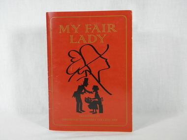
Booklet, Ringwood Secondary College, 1994 - Production Program - My Fair Lady, 8:MMMM, 1994 (exact)
A record / program of the 1994 College production "My Fair Lady" detailing all College students and staff involved in the productionCollege HistoryMy Fair Lady Production Program - 20 pagescast, 1994, ringwood secondary college, college productions, my fair lady, cast photos -
 Phillip Island and District Historical Society Inc.
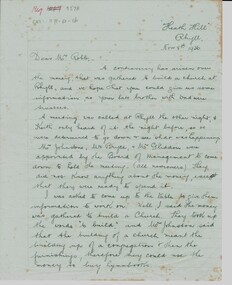
Letter, Letter re Rhyll Presbyterian church controversary over funds raised. G. McIllwraith to Mr Robb, 8/11/1936
Controversy over money previously raised to build a Presbyterian church at Rhyll, discussion of trustees and whether the money was for the building or furnishings eg hymn books. It discusses the future of the Island including a proposed Kraft cheese factory, a new bridge and shipping coal from San Remo.Historical6 pages of cream writing paper handwritten in black pen. Letter from Gwenda McIllwraith to Mr. Robb re use of monies raised to build a Presbyterian church at Rhyll."Heath Hill", Rhyll. Nov 8th, 1936. Dear Mr. Robbheath hill, gwenda mcillwraith, mr robb, presbyterian church, mr& mrs percy mcfee, mr johnston, mr bryce, mr gliddon, robert mcillwraith, rhyll, mr lock, kraft cheese co., chicory, coal mines -
Ringwood and District Historical Society
Railway timetable, Victorian Railways, Ringwood to City train timetable - May 1978, 8-May-78
Yellow coloured train timetable. Ringwood to City. -
Ringwood and District Historical Society
Certificate, Ringwood East Primary School: Certificate of Achievement 1986, 8-Jul-86
Certificate of Achievement award to "Warden-in-Charge" Dennis for creating an East Ringwood Primary School record in having all June reports in almost on time.Green with black printing single sheet Certificate of Achievement -
 Ringwood and District Historical Society
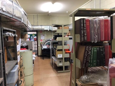
Photograph - Multiple, Ringwood Historical Society Parkwood Archives Store (North Ringwood) , August 2019, 3/8/2019
This store is used by Ringwood and District Historical Society for larger archive items, newspapers, and cartons of material yet to be catalogued. A group of digital photos of the RDHS Parkwood Archive Store in the Parkwood Community Hub, 35-39 Tortice Dr, Ringwood North VIC 3134. Taken by Ken Briscoe -
 Bendigo Military Museum
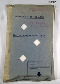
Letter - Mapping correspondence about Papua New Guinea 1970-77, Dept of Natural Resources, Army Survey Regiment, Director of Survey - Army, 1 May 1970 - 8 Aug 1977
20 x Letters, Signals and Documents pertaining to Papua New Guinea (PNG) Mapping during the period 1970-77. These documents were important authoritative documents affecting the production of PNG mapping being produced at the Army Survey Regiment at that time.Foolscap size folder containing 20 x letters/signals pertaining to Papua New Guinea mapping. Several documents both have been numbered #15.Each letter/Signal is numbered 1-20. Document 1- has "recieved" stamp, Document 2- has a note and signature MM Knight WO2, Document 3 - has 788-2-18 ad "Recieved" , Document 5 - has "Sergeant RN Sargeant" annotated, Document -11 has two file numbers and "received" stamp, Document -12 (telephone record) has recipients stamp, date and initials and file ' R750-5-1, Document -13 "received" stamp and initials, Document -15 has "received" stamp and a note "apply after TALASEA", Document -16 includes a diagram, Document -17 "Distribution List" hand written, Document -18 "received" stamp, Document 19 has note and initials, Document -20 "recipients" stamp, note and initials and "Army Survey Regiment" document stamp. royal australian survey corps, rasvy, fortuna, army survey regiment, army svy regt, asr -
 Bendigo Military Museum
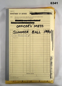
Administrative record - Army Survey Regiment Officers Mess Ball 1990, Army Survey Regiment, Bendigo, 12 Feb - 8 Mar 1990
The Army Survey Regiment held Annual Balls at Fortuna Villa. This folder contains the documentation for the Logistics and activities associated with the planning and running of the Officers Mess Summer Ball held in 1990.Manilla Correspondence Folder with grey cloth binding containing correspondence about the Army Survey Regiment Officers Mess Summer Ball of 1990.royal australian survey corps, rasvy, fortuna, army survey regiment, army svy regt, asr -
 Bendigo Military Museum
Administrative record - 1 Fd Svy Sqn Monthly Report: Dec 1979 - May 1980, 8 Dec 1980
Monthly Reports were mandatory for all RASvy UnitsA plastic bound, A4 carboard covered report that includes text and diagramsroyal australian survey corps, rasvy, fortuna, army survey regiment, army svy regt, asr -
 Bendigo Military Museum
Administrative record - 1 Fd Svy Sqn Monthly Report: Jun 1980 - Dec 1980, 1 Fd Svy Sqn, 8 Dec 1980
Monthly reports were mandatory for all RASvy UnitsA plastic bound, A4 carboard covered report that includes text and diagramsroyal australian survey corps, rasvy, fortuna, army survey regiment, army svy regt, asr -
 Warrnambool and District Historical Society Inc.
News Sheet, Warrnambool Examiner 1/10/67 - 31/12/67 : 3/1/68 - 31/3/1868, 1867-8
The Warrnambool Examiner was founded by John Wilkinson and Richard Osburne in 1851. After a gap of a couple of years Richard Osburne resumed publication In October 1853 and continued until October 1867. William Fairfax and Henry Laurie then leased the paper (1867 to 1872) before Richard Osburne again became the proprietor from October 1872 to April 1878 and from December 1870 to December 1880 when publication ceased. Richard Osburne was a pioneer settler in Warrnambool, arriving in 1847. He was prominent in community activities in the town and was a most important early historian, publishing his seminal work, ‘The History of Warrnambool’ in 1887, using the Warrnambool Examiner newspapers to assist with this history. Fairfax and Laurie were the proprietors when these papers were printed. William Fairfax was a member of the Fairfax family that were, and still are, associated with the publication of many Australian newspapers and Henry Laurie later became well-known as a Melbourne University Philosophy Professor. These original newspapers are most important because they contain much information on Warrnambool’s early history and are a primary source for historians. These papers are also of importance today as some parts of these papers were not filmed and are not currently available on microfilm. These papers were in a Warrnambool City Council storage area and it is surmised that they have come from the old Warrnambool Museum which no longer exists.These are two sets of original Warrnambool Examiner newspapers (1st October 1867 to 31st December 1867 and 3rd January 1868 to 31st March 1868), bound with cardboard, dark blue binding and string. There are six loose pages in front of the first bound set. These are broadsheets of two pages printed back and front. The papers are heavily marked with red and blue pencil and are marked, ‘private copy, F.& L.’ indicating that they are the copies the proprietors, Henry Laurie and William Fairfax, used to annotate the papers for the next edition. The pages are in good condition with some ragged edges. ‘F & L’ ‘Private copy’ warrnambool examiner, henry laurie, william fairfax, richard osburne -
 Eltham District Historical Society Inc
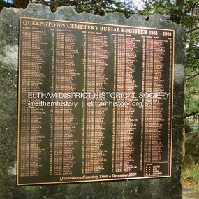
Photograph, Jim Connor, Queenstown Cemetery Burial Register 1861-1981, Queenstown Cemetery, Smiths Gully Road, St Andrews, 8 March 2023
Installed by the Queenstown Cemetery Trust December 2009 The discovery of gold in Smyth's Creek in 1854 and subsequent gold rush to the Caledonia diggings led to the establishment of Queenstown (present day St Andrews). The first recorded burial was July 31st, 1861 and it was officially declared a Cemetery Reserve in 1866. Many graves are unmarked and unrecorded including many Chinese and other itinerant miners. The cemetery was closed for new burials in 1851. The last recorded burial was in 1981 in an existing family grave.jim connor collection, 2023-03-08, queenstown cemetery, smiths gully road, st andrews -
 Eltham District Historical Society Inc
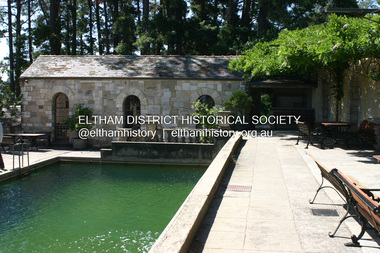
Photograph - Digital Photograph, Alan King, Swimming Pool, Montsalvat, 8 January 2008
Re-claimed material were used during the construction of Montsalvat, the artists colony in Eltham. The swimming pool was donated and cubicles were built for the students with their initials marked in tiles on each doorstep. Covered under National Estate, National Trust of Australia (Victoria) State Significance, Victorian Heritage and Heritage Overlay, Nillumbik Planning Scheme. Published: Nillumbik Now and Then / Marguerite Marshall 2008; photographs Alan King with Marguerite Marshall.; p131This collection of almost 130 photos about places and people within the Shire of Nillumbik, an urban and rural municipality in Melbourne's north, contributes to an understanding of the history of the Shire. Published in 2008 immediately prior to the Black Saturday bushfires of February 7, 2009, it documents sites that were impacted, and in some cases destroyed by the fires. It includes photographs taken especially for the publication, creating a unique time capsule representing the Shire in the early 21st century. It remains the most recent comprehenesive publication devoted to the Shire's history connecting local residents to the past. nillumbik now and then (marshall-king) collection, eltham, montsalvat, swimming pool -
 Eltham District Historical Society Inc
Photograph, Fay Bridge, Peck's Dam, Pedersen Way Reserve, Montmorency, 8 February 2019
Part of the Nillumbik Art Collectionfay bridge collection, 2019-02-08, montmorency, peck's dam, peck's pool, pedersen way reserve -
 Eltham District Historical Society Inc
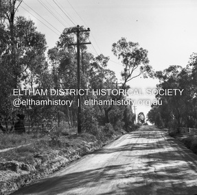
Negative - Photograph, J.A. McDonald, Rattray Road East, Montmorency, 8 May 1961
From south boundary lot looking along proposed alignment 1 May 1961Record of various Shire of Eltham infrastructure works undertaken during the period of 1952-1962 involving bridge and road reconstruction projects, sometimes with Eltham Shire Council Project Reference numbers quoted. It was during this period that a number of significant improvements were made to roads and new bridges constructed within the shire that remain in place as of present day (2022). In many situations, the photos provide a tangible visible record of infrastructure that existed throughout the early days of the Shire. The album was put together by or under the direction of the Shire Engineer, J.A. McDonald.infrastructure, montmorency, rattray road, road construction, shire of eltham, 1961-05-08 -
 Eltham District Historical Society Inc
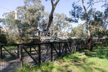
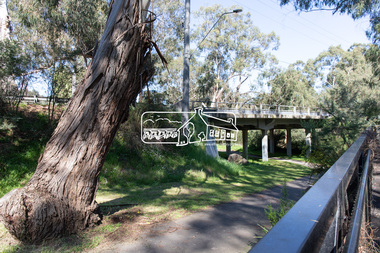
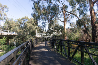
Photograph, Peter Pidgeon, Manna Gum, Main Road Bridge, Eltham South, 8 Sep. 2021
This significant tree located near the Main Road Bridge and Diamond Creek Trail footbridge over the Diamond Creek at Eltham dates back to the early 1900s. The original timber bridge over the Diamond Creek was built around 1840. It was destroyed by floodwaters in October 1923. A temporary bridge was rigged up but further damaged in April 1924. A new concrete bridge was built and opened in October 1926. The bridge decking was widened along with Main Road to Dalton Street by the Road Construction Authority in 1984., The uygraded bridge was opened in October 1984, 78 years after its original opening.These trees are not only significant for the natural environment but also present a navigational beacon back in time as the environmental landscape is developed around them.Born Digitaleltham south, main road bridge, manna gum, significant tree, diamond creek trail -
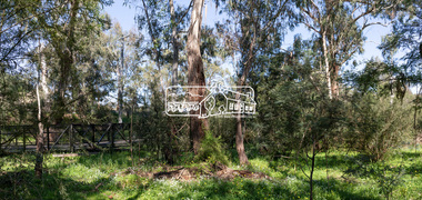
 Eltham District Historical Society Inc
Photograph, Peter Pidgeon, Manna Gum, Main Road Bridge, Eltham South, 8 Sep. 2021
This significant tree located near the Main Road Bridge and Diamond Creek Trail footbridge over the Diamond Creek at Eltham dates back to the early 1900s. The original timber bridge over the Diamond Creek was built around 1840. It was destroyed by floodwaters in October 1923. A temporary bridge was rigged up but further damaged in April 1924. A new concrete bridge was built and opened in October 1926. The bridge decking was widened along with Main Road to Dalton Street by the Road Construction Authority in 1984., The uygraded bridge was opened in October 1984, 78 years after its original opening.These trees are not only significant for the natural environment but also present a navigational beacon back in time as the environmental landscape is developed around them.Born Digitaleltham south, main road bridge, manna gum, significant tree, diamond creek trail -
 Eltham District Historical Society Inc
Photograph, Peter Pidgeon, Manna Gums, Main Road Bridge, Eltham South, 8 Sep. 2021
The original timber bridge over the Diamond Creek was built around 1840. It was destroyed by floodwaters in October 1923. A temporary bridge was rigged up but further damaged in April 1924. A new concrete bridge was built and opened in October 1926. The bridge decking was widened along with Main Road to Dalton Street by the Road Construction Authority in 1984., The uygraded bridge was opened in October 1984, 78 years after its original opening.These trees are not only significant for the natural environment but also present a navigational beacon back in time as the environmental landscape is developed around them.Born Digitaleltham south, main road bridge, manna gum, diamond creek trail -
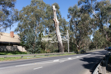
 Eltham District Historical Society Inc
Photograph, Peter Pidgeon, Manna Gum, Main Road Bridge, Eltham South, 8 Sep. 2021
This significant tree located near the Main Road Bridge and Diamond Creek Trail footbridge over the Diamond Creek at Eltham dates back to the early 1900s. The original timber bridge over the Diamond Creek was built around 1840. It was destroyed by floodwaters in October 1923. A temporary bridge was rigged up but further damaged in April 1924. A new concrete bridge was built and opened in October 1926. The bridge decking was widened along with Main Road to Dalton Street by the Road Construction Authority in 1984., The uygraded bridge was opened in October 1984, 78 years after its original opening.These trees are not only significant for the natural environment but also present a navigational beacon back in time as the environmental landscape is developed around them.Born Digitaleltham south, main road bridge, manna gum, significant tree, diamond creek trail -
 Eltham District Historical Society Inc
Photograph, Peter Pidgeon, Manna Gum, Main Road Bridge, Eltham South, 8 Sep. 2021
This significant tree located near the Main Road Bridge and Diamond Creek Trail footbridge over the Diamond Creek at Eltham dates back to around 1870-1880. The original timber bridge over the Diamond Creek was built around 1840. It was destroyed by floodwaters in October 1923. A temporary bridge was rigged up but further damaged in April 1924. A new concrete bridge was built and opened in October 1926. The bridge decking was widened along with Main Road to Dalton Street by the Road Construction Authority in 1984., The uygraded bridge was opened in October 1984, 78 years after its original opening.These trees are not only significant for the natural environment but also present a navigational beacon back in time as the environmental landscape is developed around them.Born Digitaleltham south, main road bridge, manna gum, significant tree, diamond creek trail -
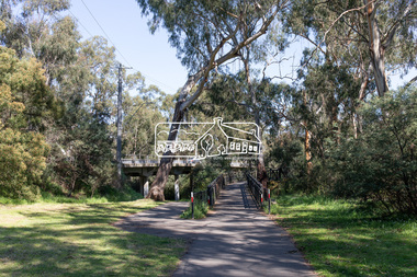
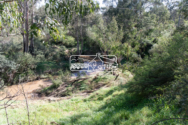
 Eltham District Historical Society Inc
Photograph, Peter Pidgeon, Manna Gum, Main Road Bridge, Eltham South, 8 Sep. 2021
This significant tree located near the Main Road Bridge and Diamond Creek Trail footbridge over the Diamond Creek at Eltham dates back to around 1870-1880. The original timber bridge over the Diamond Creek was built around 1840. It was destroyed by floodwaters in October 1923. A temporary bridge was rigged up but further damaged in April 1924. A new concrete bridge was built and opened in October 1926. The bridge decking was widened along with Main Road to Dalton Street by the Road Construction Authority in 1984., The upgraded bridge was opened in October 1984, 78 years after its original opening.These trees are not only significant for the natural environment but also present a navigational beacon back in time as the environmental landscape is developed around them.Born Digitaleltham south, main road bridge, manna gum, significant tree, diamond creek trail -
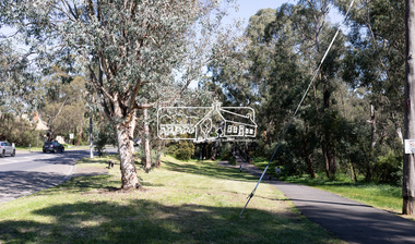
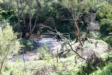 Eltham District Historical Society Inc
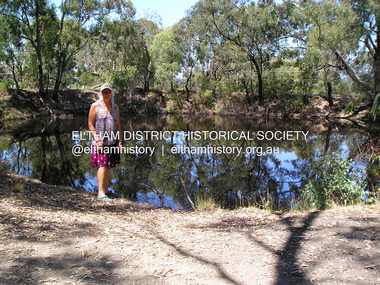
Photograph, Peter Pidgeon, Diamond Creek near Main Road Bridge, Eltham South, 8 Sep. 2021
Evidence of flooding from recent winter and early spring rainBorn Digitaleltham south, diamond creek trail, diamond creek (creek), floods -
 Eltham District Historical Society Inc
Photograph, Peter Pidgeon, Diamond Creek near Main Road Bridge, Eltham South, 8 Sep. 2021
Evidence of flooding from recent winter and early spring rainBorn Digitaleltham south, diamond creek trail, diamond creek (creek), floods -
 Eltham District Historical Society Inc
Document, Nillumbik Shire Council, Information Bulletin, 1996 Nillumbik Festival, 8 Aug 1996
In 1996 the Eltham Festival was renamed the Nillumbik Festival, centred around Alistait Knox Park and the Rugby Oval. The theme for the 1996 Nillumbik Festival held 9-10 November 1996 was "Celebrating Our Lifestyle" Information bulletin issued by Nillumbik Shire Council addressing how community groups can be involved and interpretation of the festival's theme covering the Grand Parade, Stage performance and sporting displays and Stalls3 x A4 photocopy, various coloured papereltham community festival, eltham festival, 1996, nillumbik festival -
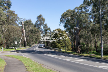
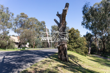 Eltham District Historical Society Inc
Photograph, Peter Pidgeon, Manna Gum, Main Road, Eltham South, 8 Sep. 2021
This significant tree located near the Main Road Bridge over the Diamond Creek at Eltham dates back to approximately 1870-1880. Though dead now, its trunk has been left as a wildlife habitat.These trees are not only significant for the natural environment but also present a navigational beacon back in time as the environmental landscape is developed around them.Born Digitaleltham south, main road bridge, manna gum, significant tree -
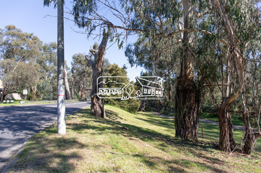
 Eltham District Historical Society Inc
Photograph, Peter Pidgeon, Manna Gum, Main Road, Eltham South, 8 Sep. 2021
This significant tree located near the Main Road Bridge over the Diamond Creek at Eltham dates back to approximately 1870-1880. Though dead now, its trunk has been left as a wildlife habitat.These trees are not only significant for the natural environment but also present a navigational beacon back in time as the environmental landscape is developed around them.Born Digitaleltham south, main road bridge, manna gum, significant tree