Showing 3082 items
matching bendigo mine
-
 Bendigo Historical Society Inc.
Map - MINE LOCATION DRAWING AT VICTORIA HILL
Claims and shafts location for: Rae and co. - Noye and co. - Wittscheibe. Some additions to drawing made in pencil.mining, business -
Bendigo Historical Society Inc.
Photograph - FORTUNA COLLECTION: AERIAL VIEW OF BENDIGO 1963
Black and white photograph, aerial view of Bendigo 1963, Fortuna Villa in foreground. On bottom of photograph ' Fortuna, an aerial view of Bendigo Circa 1963' Fortuna Villa in foregound of image, showing very clear detail of grounds. Image has labels of following sites: Lansell's 222 mine Lazarus mine site Central Red, White and Bluye mine site, Old Chum mine site New Chum and Victoria mine site West End Hall Mount Alvernia BCV8 QEO -
Bendigo Historical Society Inc.
Photograph - FORTUNA COLLECTION: POPPET HEAD, CHIMNEY AND BUILDINGS
Black and white photograph ( copy) of mine site. Image shows metal poppethead with elevated tramway leading off on right hand side. Buildings in foreground appear to be set down lower then surrounding land. On left hand side is the 'needle' chimney with a mine shed in foreground. -
 Bendigo Historical Society Inc.
Map - BENDIGO GOLDFIELDS MAP
... Map of the Bendigo Goldfield, showing reef lines, mines... 'Department of Mines, Victoria. Plan of Bendigo Goldfield. Map BENDIGO ...Map of the Bendigo Goldfield, showing reef lines, mines and significant geographical features such as Monument Hill, Quartz Hill and Diamond Hill. On the back of map 'Department of Mines, Victoria. Plan of Bendigo Goldfield.bendigo, mining, bendigo goldfields -
 Bendigo Historical Society Inc.
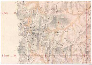
Map - DIAMOND HILL AREA
Copy of map of Diamond Hill area, with the Trig Station mid centre on map. Shafts, mines and geological features are marked.bendigo, mining, diamond hill -
 Bendigo Historical Society Inc.
Document - DIAMOND HILL AREA MAP
Map copy, 2 pages, from 'Old Mines Department Plan, Dept of Conservation and Environment File No W91006, 16.6.1972' Map shows Golden Gully area with 'Town and Country Hotel' on north side and further south, with shafts and mine names marked.bendigo, mining, diamond hill -
 Bendigo Historical Society Inc.
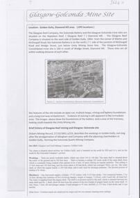
Document - GLASGOW GONCONDA MINE SITE DIAMOND HILL
Brief description of the Glasgow Golconda mine site and the Glasgow Reef mining history. The site is Glasgow Golconda mine is situated midway up Golden Gully is bounded on the north by Hill & Co's and on the south by the Golconda Company's ground.bendigo, mining, glasgow golconda -
 Bendigo Historical Society Inc.
Document - GLASGOW REEF WORKINGS DIAMOND HILL
One page document detailing the Glasgow Reef workings on the Napoleon Reef, Diamond Hill. Report prepared by David Bannear. Mining companies mentioned in the report are Glasgow Reef Co., Golconda Battery and the Glasgow Golconda Consolidated Mine.bendigo, mining, glasgow reef workings -
 Bendigo Historical Society Inc.
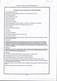
Document - GLASGOW AND GOLCONDA CONSOLIDATED GOLD MINE
... BENDIGO Mining glasgow golconda mine site Information regarding ...Information regarding the Glasgow and Golconda Consolidated Gold Mine, Golden Gully. Mine is on the Napoleon Reef, shaft depth of 800 ft. A description of the physical remains is given and the significance of the site is described. It is the only site in Bendigo 'which retains evidence of the tramway between the mine and the battery site'bendigo, mining, glasgow golconda mine site -
 Bendigo Historical Society Inc.
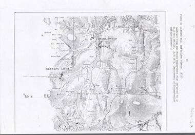
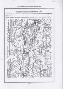
Document - DIAMOND HILL, GOLDEN GULLY COSERVATION AREA
Map of Golden Gully conservation area comprising Glasgow and Golconda Consolidated, Glasgow Reef Company (Golden Gully) and New Napoleon. The area is significant because it contains the 'best evidence for hydraulic sluicing on the field as well as several early reef mining sites' On top of page 'Eaglehawk & Bendigo Heritage Study, Significant areas' Mines marked on page: Goldfields Extended shaft South Concord shaft Concord shaft Morning Light shaft Hansel and Mundy shaftbendigo, mining, golden gully -
Bendigo Historical Society Inc.
Document - CARSHALTON REEF, DIAMOND HILL MINES
Table of information regarding the mines situated along the Carshalton line of Reef, includes Stafford Reef mine.bendigo, mining, carshalton reef line -
 Bendigo Historical Society Inc.
Document - STAFFORD REEF MINE SITE, DIAMOND HILL
... BENDIGO Mining stafford reef mine One page document describing ...One page document describing the Stafford Reef Mine Site, Diamond Hill, Site 4.11, prepared by David Bannear. Information includes the map/grid references of the site and an overview of the history of the Stafford Reef Mine. The physical remains of the mine are described..bendigo, mining, stafford reef mine -
 Bendigo Historical Society Inc.
Photograph - ESTELLE HEWSTON COLLECTION: GOLD MINES HOTEL FAÇADE, MARONG ROAD, JANUARY 1994
Colour photograph of Gold Mines Hotel, dated January 1994Estelle Hewston -
Bendigo Historical Society Inc.
Document - GOLDEN DRAGON MUSEUM COLLECTION: DAI GUM SAN WAX MUSEUM
Four pages brochure Dai Gum San wax Museum. Temporary premises Temperance Hall, View Street Bendigo. On the two inside pages a description of the collection. On the back two photos of the Central Deborah gold mine and one of the tramways museum.bendigo, chinese, dragon museum -
Bendigo Historical Society Inc.
Document - ALBERT RICHARDSON COLLECTION: BLACK FOREST COMPANY
Five page handwritten and typed document with information about the Black Forest Gold Mine on the Hustler's line of reef. The Black Forest mine was situated one mile north of the Eaglehawk Post Office. To the west was the South New Moon on the Garden Gully line of reef and to the east was the Lightning Hill line of reef worked by open cutting to a depth of over 100 ft by Pascoe and Simonds. A party of Germans named 'Rothacker and Party', first worked the claim on the Black Forest mine approx 1860. Other mines worked on the Hustler's line north of the Black Forest were: Martha Company. Johns and company and Meaner (unclear) and Co.bendigo, mining, black forest gold mine -
 Bendigo Historical Society Inc.
Document - CURNOW COLLECTION: INVITATION TO MR J. H. CURNOW, 24/04/1905
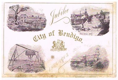
Invitation to Mr. J. H. Curnow to attend a dinner on the occasion of the first official visit of His Excellency Major-General The Hon. Sir Reginald Arthur James Talbot, K. C. B., Governor of Victoria and to celebrate the Jubilee of the Municipality on Monday, April 24th, 1905. On the front of the invitation, printed in gold is: Jubilee City of Bendigo 1855 -1905. Gold border 5mm from the edge. There are four scenes on the front, Pall Mall in 1855, Pall Mall in 1905, Mining in 1855 and South New Moon Mine 1905. On the inside is a scene of the Municipal Offices 1855 and the Town Hall 1905. On the right is the invitation. On the back cover is the City of Bendigo emblem and printed at the bottom is Town Hall, Bendigo, 1905 and A. Dunstan, Mayor.document, invitations, official celebrations, document, invitatioin to mr j h curnow, city of bendigo jubilee 1855 - 1905, south new moon mine, pall mall, municipa offices, town hall, j h curnow, his excellency major-general the hon. sir reginald arthur james talbot k c b governor of victoria -
 Bendigo Historical Society Inc.
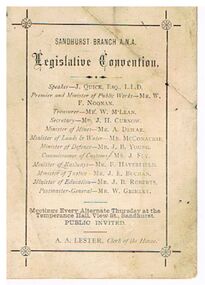
Document - DOCUMENT - SANDHURST BRANCH A. N. A. LEGISLATIVE CONVENTION
Small, white card, Sandhurst Branch A. N. A. Legislative Convention. Possibly 1889, see newspaper article 22nd August, 1889, Bendigo Advertiser. Named are the Speaker - J. Quick, Esq., L. L. D., Premier and Minister of Public Works - Mr. W. F. Noonan, Treasurer - Mr. W. McLean, Secretary - Mr. J. H. Curnow, Minister of Mines - Mr. A. Dewar, Minister of Lands & Water - Mr. McConachie, Minister of Defence - Mr. J. B. Young, Commissioner of Customs - Mr. J. Fry, Minister of Railways - Mr. F. Haverfield, Minister of Justice - Mr. J. E. Buchan, Minister of Education - Mr. J. B. Roberts, Postmaster-General - Mr. W. Grimley. A. A. Lester, Clerk of the House. ' Meetings every alternate Thursday at the Temperance Hall, View Street, Sandhurst.' Printing surrounded by border with a flower where the corners intersect. On the back is a drawing with a vase of flowers sitting on a raised part which is wider at the bottom. It has a plant engraving and underneath are two doves and a feather pattern fan.bendigo, clubs, ana, document, sandhurst branch a. n. a., j quick, w f noonan, w mclean, j h curnow, a dewar, mr mcconachie, j b young, j fry, f haverfield, j e buchan, j b roberts, w grimley, a a lester -
 Bendigo Historical Society Inc.
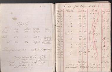
Document - JOHN EVANS COLLECTION: CYANIDE OPERATION RECORDS: APRIL 1900 TO MARCH 1901
Cyanide Operation Records (April 1900-March 1901; Statements/Petty Cash April 1900 -March 1901. Listed as #10 - only as Cyanide operation records. Cyanide operation records are headed on each page as ‘‘Vats for (month (year)''. Operation Records and financial statements are entered separately from the front and back of the book. In centre, between these entries are some torn out pages plus handwritten copy of a draft?? Letter to The Hon the Minister of Mines re some miners' ''unfortunate situation'' - requesting an interview in relation to the matter concerning a mining lease issue and trespass. No name is attached as a signature to indicate the author of said letter.bendigo, industry, sebastian cyanide works, cyanide operation records -
Bendigo Historical Society Inc.
Map - NEW CHUM & VICTORIA LINES OF REEF - PLAN OF NEW CHUM & VICTORIA LINES OF REEF
Two pages of a Plan of New Chum & Victoria Lines of Reef, compiled by G. W. Hart. Taken from J. N. Macartney's G'Fields Registry for 1871. Plan shows leases from High Street to California Gully. Location of the Manchester Arms, British & American Hotel and the Quartz Miners Arms are shown. Townships of Long Gully and Ironbark are shown.map, goldfields, new chum & victoria lines of reef, plan of new chum & victoria lines of reef, victoria catharine g m coy, thornton & co, extd victoria reef g m co, ural tribute compy, nil desperandum compy, koch, north victoria g m co, danger hill coy, north endeavour coy, wheadon & co, pilot co, north energetic co, energetic compy, endeavour company, hercules co, victoria gold mines compy, iron duke g m co, golden fleece united, ballerstedt, alfred co, confidence co, prince alfred co, canterbury co, advance co, wells, humboldt co, adventure co, try me well, sterry & co, gibbs & ballerstedt, handy andy, wells?, south adventure co, w rae, victoria reef quartz m co, myra co, jackson, wybrants, burrows & sterry, new chum & victoria tribute, old chum co, ballerstedt, lazarus, watson, koch & hildebrand, lansell & hunt, dennis, abe lincoln co, bonati & co, ellesmere co, moore late menzies, british co, british tribute co, garibaldi, c c co, new chum trib, dobson & co, young chum co, little chum co, old chum co, new chum trib, little chum trib, g w hart, j n macartney's g'fields registry for 1871, manchester arms, british & american, quartz miners arms -
Bendigo Historical Society Inc.
Document - NEW CHUM LINE OF REEF - LEASE SANDHURST NO 100 NEW CHUM COMPANY
Handwritten page of notes on the New Chum Company, Lease Sandhurst No 100. Notes give period of lease, locality, nature of lease and area of lease. In 1863 there was a disagreement with neighbouring leases. By 22/10/1866 Leases 81, 100.113.306,424,425 & 872 were surendered and R Schlesinger on behalf of New Chum Co was granted a new lease in their place. Item 7 Lease details, Edward Hunt & Anthony Stephens, Lease holders Application lodged 13/8/1859 No 134. Date 5/3/1860 for a term of ten years. Reference; Lease Book, Mines Department.document, gold, new chum line of reef, new chum line of reef, lease sandhurst no 100 new chum company, d mcdougall, menzies claim, r schlesinger, edward hunt, anthony stephens, lease book mines dept -
Bendigo Historical Society Inc.
Document - NEW CHUM LINE OF REEF - GOLD PRODUCTION ON THE NEW CHUM LINE OF REEF
Hand written page containing the names of mines and the number of ounces of gold they produced. Mines mentioned are: Lansell's 222, Lazarus New Chum, Old Chum, New Chum & Victoria, North Old Chum, Lansell's Big 180, Victoria Quartz, Gt Central Victoria, Victoria Consols, South Adventure Group, Adventure, Advance, Try - Me - Well, Prince Alfred, Alfred Co, Lansell's 83 and Ironbark (no production figures). Note beside Alfred & Co - Land pegged by J R Evans in 1857.document, gold, new chum line of reef, new chum line of reef, gold production on the new chum line of reef, lansell's 222, lazarus new chum, old chum, new chum & victoria, north old chum, lansell's big 180, victoria quartz, gt central victoria, victoria consols, south adventure group, adventure, advance, try - me - well, prince alfred, alfred co, lansell's 83, ironbark, j r evans -
Bendigo Historical Society Inc.
Document - NEW CHUM LINE OF REEF - EXTRACTS FROM WM WELCH'S BOOKS
... Mines 1883 Wm Welch's Bendigo Mining Registry Wm Welch's Guide ...Three pages of notes on Garibaldi, Ellesmere Co No 1, New Chum Consolidated Co N. L.,New Chum United Co, Lazarus New Chum Co Reg'd and Lazarus New Chum No 1. Notes include Legal Manager, Mining Manager, size od lease, machinery, information on shares and dividends. Henry von der Hyde was the Legal Manager of the Garibladi and W Martin, the Mine Manager. John Neeson, the Legal Manager of the Ellesmere Co No 1 and Henry Reed, Mine Manager. Henry Von der Hyde, Legal Manager of New Chum Sonsolidated Co N L and Thomas Sheppard, Mine Manager. Henry von der Hyde, Legal Manager of New Chum United N L and John Harvey, Mine Manager. Lazarus New Chum Co Reg'd and Lazarus New Chum No 1 Co Reg'd, Henry von der Hyde, Legal Manager and George Armstrong, Mine Manger to both companies.document, gold, new chum line of reef, new chum line of reef, extracts from wm welch's books, garibaldi mining & crushing co n l, henry von der hyde, w martin, ellesmere co no 1 n l, john neeson, henry reed, new chum consolidated co n l, thomas sheppard, menzies claim, new chum united co n l, john harvey, bonate's claim, old new chum, geo lansell, lazarus new chum co reg'd, lazarus new chum no 1 co reg'd, george armstrong, gibbs, lazarus, wm welch's bendigo gold mines 1883, wm welch's bendigo mining registry, wm welch's guide to the bendigo gold mines -
Bendigo Historical Society Inc.
Document - NEW CHUM LINE OF REEF - REFERENCE TO CALEB THOMAS PLANS
... Bendigo Historical Society Inc. Bendigo Historical Society ...Five pages of reference numbers used on Caleb Thomas plans. Has the mine's name, size of shaft and on other pages, the height of the sill. One mine on the Sheepshead Line, the New St Mungo is mentioned. Many mines along the reef are mentioned.document, gold, mines, new chum line of reef, reference to caleb thomas plans, catherine reef extd., new franklin, murchison, catherine reef united, catherine reef (south), williams (new), acadia catherine, william's united, york & durham, belmont & saxby, ellenborough, sadowa, (old) st mungo, lady barkly, princess alice (sth st mungo), unicorn trib, pheonix, hopewell, united devonshire (princess alex), west united devonshire, east united devonshire, duchess of edinburgh, south devonshire, duchess tribute, new st mungo, new st mungo, new vict catherine, gt extd vict, herc new chum (late pearl), pearl south, north herc & energetic, herc & energetic, ironbark, vict consols, south new chum, lansell's 616, south belle vue, eureka extd, new chum rly, south old chum, new chum consolidated, ellesmere (south shaft), garibaldi, cravens, young chum, ellesmere nth shaft, new chum united, new chum vic, old chum, lazarus, cent new chum, lansell's 222, north old chum, lansell's big 180, advents advance, gt cent vict, hamboldt, ballerstedt, victoria quartz, herc & energetic, herc (old), shenandoah, victoria reef gold, victoria consols -
Bendigo Historical Society Inc.
Document - NEW CHUM LINE OF REEF - PART OF A PLAN OF MINES ALONG THE NEW CHUM LINE OF REEF
Sketch of mines along the New Chum Line Of Reef Sheet No 1 (811) Caleb Thomas Jun 28, 1879. Mines mentioned are the Hercules and the Energetic. The others are shaft numbers. Measurements between each in feet and yards. Probable course of cap of Victoria Reef drawn in.document, gold, new chum line of reef, new chum line of reef, part of a plan of mines along the new chum line of reef, caleb thomas, hercules mine, energetic mine, energetic coy -
Bendigo Historical Society Inc.
Document - NEW CHUM LINE OF REEF - PLAN OF MINES ALONG PART OF THE NEW CHUM LINE OF REEF
Sketch of some mines along the New Chum Line Of Reef. Sheet No (178) Caleb Thomas 1879 Jan 29th. Mines mentioned are: Prince Alfred, Victoria Consols, G Lansell's No 83. Some mines are only a number. Victoria Reef Gold Mines are mentioned. Distances in feet or yards between them.document, gold, new chum line of reef, new chum line of reef, plan of mines along part of the new chum line of reef, caleb thomas, prince alfred mine, victoria consols, g lansell's no 83, ironbark, victoria reef gold mines -
Bendigo Historical Society Inc.
Document - NEW CHUM LINE OF REEF - SKETCH OF MINES ALONG THE NEW CHUM LINE OF REEF
Sketch of mines along part of the New Chum Line Of Reef. Sheet No 1 (179). Caleb Thomas Jan 28th 1879. Plan. Hercules and Energetic Mines on drawing, 430 feet apart.document, gold, new chum line of reef, new chum line of reef, sketch of mines along the new chum line of reef, hercules, energetic, caleb thomas -
 Bendigo Historical Society Inc.
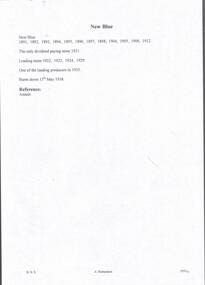
Document - NEW BLUE MINE - NOTES ON THE NEW BLUE MINE
... Mine Annals of Bendigo Handwritten notes on the New Blue Mine ...Handwritten notes on the New Blue Mine from the Annals. 'New Blue, 1891, 1892, 1893, 1894,1895,1896, 1897, 1898, 1904,1905, 1906, 1912. The only dividend paying mine 1921. Leading mine 1922, 1923,1924,1929. One of the leading producers in 1935. Burnt down 13th May 1938. List of references on the second page crossed out.document, gold, new blue mine, new blue mine, notes on the new blue mine, annals of bendigo -
Bendigo Historical Society Inc.
Document - DEVONSHIRE & MUNGO MINES - LOCATIONS OF THE DEVONSHIRE & MUNGO MINES
... Inc. History House 11 Mackenzie Street Bendigo goldfields MINE ...Tracing of streets, school sand heaps and dam at Eaglehawk titled Devonshire & Mungo Mines. At the top of the page is sketches of the chimney of the 'Big 180', Old Chum Mine, United Devonshire and Old St Mungo Mines. Also a sketch of a windlass, whip & remains of whim. Eaglehawk.mine, gold, devonshire & mungo mines, devonshire & mungo mines, locations of the devonshire & mungo mines, eaglehawk, chimney of the big 180, old chum mine, united devonshire, old st mungo -
Bendigo Historical Society Inc.
Document - MUNGO GROUP - NOTES ON MUNGO GROUP
... Bendigo Historical Society Inc. Bendigo Historical Society ...Handwritten notes on the Mungo Group of mines. Notes include Dividends, Calls,Depth of shaft, area of lease and gold found. Mines mentioned are: Phoenix, Unicorn, South St Mungo, Governor Barkly, Lady Barkly, St Mungo, Sadowa and Eastwood's.gold mines, mungo group, notes on the mungo group, phoenix, unicorn, south st mungo, governor barkly, lady barkly, st mungo, sadowa, eastwood's -
Bendigo Historical Society Inc.
Newspaper - VICTORIA: ITS MINES AND MINERALS
Two copies of pages, one from Victoria: Its Mines and Minerals page 40, dated June1, 1899 and one from Special Edition Australian Mining Standard, page 41, dated June 1, 1899. Page 40 has a picture of Lansell's '180'. Reports on yields,dividends,depths, where the gold was found, amount of gold per load, and working the mines. Mines mentioned are: Tribute Company, North Old Chum, The 180,The Victoria QuartzNew Chum United, The Great Central Victoria, Victoria Consols, The Adventure, The Try-Me-Well, The Advance, The Cinderella, The Hercules Group, Ironbark Co, Victoria Gold Mines Co, Hercules & Energetic, Great Extended Hercules, The Pearl, New St Mungo, The Extended South Devonshire, Duchess Tribute, The Duchess of Edinburgh Co,Freeman & Co, The Danes.gold mining, miners' safety cage, victoria: its mines and minerals, victoria: its mines and minerals, special edition australian mining standard, tribute co, mr w w barker, mr hicks, lansell's 180, north old chum, mr john wybrants, victoria reef, ballerstedt, geo lansell, victoria quartz, victoria hill, great central victoria, new chum united, mr j h craig, victoria consols, the adventure, try - me - well, the advance, the cinderella, the albert, the hercules group, ironbark co, the victoria gold mines co, the hercules and energetic, the great extended hercules, the pearl, new st mungo, the extended south devonshire, duchess tribute, the south devonshire, the duchess of edinburgh co, freeman and co, the danes