Showing 1656 items matching " site plans"
-
 Whitehorse Historical Society Inc.
Article, Make-over for ex-quarry site, 2005
... A development has been planned for the old quarry site on Middleborough Road....Whitehorse Historical Society Inc. 2-10 Deep Creek Road Mitcham melbourne Quarries Brick Industries Limited Middleborough Road Burwood East Brickworks A development has been planned for the old quarry site on Middleborough Road. A development has been planned for the old quarry site on Middleborough Road. ...A development has been planned for the old quarry site on Middleborough Road.A development has been planned for the old quarry site on Middleborough Road.A development has been planned for the old quarry site on Middleborough Road.quarries, brick industries limited, middleborough road, burwood east, brickworks -
 Whitehorse Historical Society Inc.
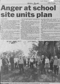
Newspaper - Article, Anger at school site plan, 23/10/1996
... Anger at school site plan...Anger at school site plan Newspaper Article ...Article in Whitehorse Gazette 28/10/1996 about objections by neighbouring residents to development of the Forest Hill Secondary College site.forest hill secondary college, mahoneys road, forest hill, canterbury road, thornhill drive, oscar, geoff, land subdivision -
Whitehorse Historical Society Inc.
Article, MP Reveals Council Plans for old School Site, 2014
... A rift has developed between Whitehorse Council and a Mitcham MP after it was revealed the council is considering buying the former school site. MP Reveals Council Plans for old School Site Article Article ...A rift has developed between Whitehorse Council and a Mitcham MP after it was revealed the council is considering buying the former school site.A rift has developed between Whitehorse Council and a Mitcham MP after it was revealed the council is considering buying the former school site.A rift has developed between Whitehorse Council and a Mitcham MP after it was revealed the council is considering buying the former school site.city of whitehorse, nunawading primary school no.4190, springvale road, nunawading, ryall dee, ellis sharon, stennett ben, daw philip, challinger michael, nunawading primary school site preservation group -
Whitehorse Historical Society Inc.
Article, Fight for leafy site
... Whitehorse Historical Society Inc. 2-10 Deep Creek Road Mitcham melbourne Trees Mitcham Road Mitcham No. 520 Planning development Hogg Tony Mitcham Residents' Association Reid Jo Whitehorse Council refuses plans for 37 unit development at 520 Mitcham Road Mitcham Whitehorse Council refuses plans for 37 unit development at 520 Mitcham Road Mitcham Fight for leafy site Article Article ...Whitehorse Council refuses plans for 37 unit development at 520 Mitcham Road MitchamWhitehorse Council refuses plans for 37 unit development at 520 Mitcham Road MitchamWhitehorse Council refuses plans for 37 unit development at 520 Mitcham Road Mitchamtrees, mitcham road, mitcham, no. 520, planning development, hogg, tony, mitcham residents' association, reid, jo -
Whitehorse Historical Society Inc.
Article, Brickworks Set in Stone, 2016
... A draft plan for the 20 ha site of the former brickworks in Burwood East has been approved to include 950 homes, a kindergarten, an urban plaza and shopping centre....Brickworks Burwood East Burwood Heights A draft plan for the 20 ha site of the former brickworks in Burwood East . ...A draft plan for the 20 ha site of the former brickworks in Burwood East .A draft plan for the 20 ha site of the former brickworks in Burwood East has been approved to include 950 homes, a kindergarten, an urban plaza and shopping centre.A draft plan for the 20 ha site of the former brickworks in Burwood East . brickworks, burwood east, burwood heights -
Whitehorse Historical Society Inc.
Map, Kylana Estate Tunstall, 1926
... Auctioneer's plan of sub-division of Kylana Estate Tunstall, 8 sites, 2nd Oct 1926. ...Auctioneer's plan of sub-division of Kylana Estate Tunstall, 8 sites, 2nd Oct 1926. ...Auctioneer's plan of sub-division of Kylana Estate Tunstall.Auctioneer's plan of sub-division of Kylana Estate Tunstall, 8 sites, 2nd Oct 1926. Auctioneer: Sergeant & LehmannAuctioneer's plan of sub-division of Kylana Estate Tunstall.heather grove tunstall, kylana estate, springvale road tunstall, tunstall -
Whitehorse Historical Society Inc.
Map, Blackburn Heights Estate, 1923
... Auction plans of sub-division for Blackburn heights Estate, 130 sites, 8th December 1923...Auction plans of sub-division for Blackburn heights Estate, 130 sites, 8th December 1923 Blackburn Heights Estate Map Map ...Auction plans of sub-division for Blackburn heights Estate.Auction plans of sub-division for Blackburn heights Estate, 130 sites, 8th December 1923Auction plans of sub-division for Blackburn heights Estate.springfield road blackburn north, surrey road blackburn north, gordon street blackburn north, koonung road blackburn north, harris street blackburn north, hirst street blackburn north, deane street blackburn north, blackburn heights estate, blackburn north -
 Whitehorse Historical Society Inc.
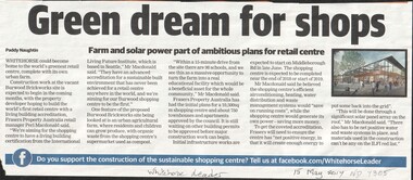
Article, Green dream for shops
... The Burwood brickworks site in Middleborough Road may become the world's first retail centre with a living building accreditation. There are plans...Whitehorse Historical Society Inc. 2-10 Deep Creek Road Mitcham melbourne brickworks retail trade middleborough road environment The Burwood brickworks site in Middleborough Road may become the world's first retail centre with a living building accreditation. There are plans ...The Burwood brickworks site in Middleborough Road may become the world's first retail centre with a living building accreditation. There are plans for a 10,500 sq. m. shopping centre and 750 townhouses and apartments.brickworks, retail trade, middleborough road, environment -
 Whitehorse Historical Society Inc.
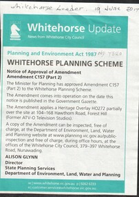
Article, Heritage Overlay - Formal ATV-0, 2017
... The Minister for Planning has approved amendment C157 (Part 2) to the Whitehorse Planning Scheme which applies a Heritage Overlay HO 272 partially over the site at 104 -168 Hawthorn Road, Forest Hill (Former ATV 0 Television Studios)...Whitehorse Historical Society Inc. 2-10 Deep Creek Road Mitcham melbourne heritage overlay city of whitehorse hawthorn road forest hill no. 104 -168 television stations channel 0 tv studios The Minister for Planning has approved amendment C157 (Part 2) to the Whitehorse Planning Scheme which applies a Heritage Overlay HO 272 partially over the site at 104 -168 Hawthorn Road, Forest Hill (Former ATV 0 Television Studios) Heritage Overlay - Formal ATV-0 Article Article ...The Minister for Planning has approved amendment C157 (Part 2) to the Whitehorse Planning Scheme which applies a Heritage Overlay HO 272 partially over the site at 104 -168 Hawthorn Road, Forest Hill (Former ATV 0 Television Studios)heritage overlay, city of whitehorse, hawthorn road, forest hill no. 104 -168, television stations, channel 0 tv studios -
Whitehorse Historical Society Inc.
Article, New Plan for Servo, 2015
... A developer has lodged plans with Whitehorse Council for a three-storey building on the former Caltex site on Blackburn Road....A developer has lodged plans with Whitehorse Council for a three-storey building on the former Caltex site on Blackburn Road. ...A developer has lodged plans with Whitehorse Council for a three-storey building on the former Caltex site on Blackburn Road.A developer has lodged plans with Whitehorse Council for a three-storey building on the former Caltex site on Blackburn Road.A developer has lodged plans with Whitehorse Council for a three-storey building on the former Caltex site on Blackburn Road.blackburn road, blackburn, blackburn village shopping centre, service stations -
 Whitehorse Historical Society Inc.
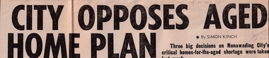
Article, City opposes Aged home plan, 1976
... sites were to be reviewed. The geriatric centre sponsored by eastern suburbs municipalities with State government backing will have a reduced number of beds. City opposes Aged home plan ...The Vermont South geriatric project was opposed by council and other sites were to be reviewed.The Vermont South geriatric project was opposed by council and other sites were to be reviewed. The geriatric centre sponsored by eastern suburbs municipalities with State government backing will have a reduced number of beds.The Vermont South geriatric project was opposed by council and other sites were to be reviewed. city of nunawading, nursing homes, meagher, ray -
Whitehorse Historical Society Inc.
Map, Springfield Road, Blackburn, 1924
... Plan of subdivision, parts of Crown Portions 73 and 74, parish of Nunawading, County of Bourke. Passed by MMBW 24 May 1924. Subdivision not implemented. Originally owned by Leonard Sherwin Bayley, then by Edward Henry Pearce, then by Ron Pearce. Part compulsorily acquired as site...Plan of subdivision, parts of Crown Portions 73 and 74, parish of Nunawading, County of Bourke. Passed by MMBW 24 May 1924. Subdivision not implemented. Originally owned by Leonard Sherwin Bayley, then by Edward Henry Pearce, then by Ron Pearce. Part compulsorily acquired as site ...Plan of subdivision, parts of Crown Portions 73 and 74, parish of Nunawading, County of Bourke.Plan of subdivision, parts of Crown Portions 73 and 74, parish of Nunawading, County of Bourke. Passed by MMBW 24 May 1924. Subdivision not implemented. Originally owned by Leonard Sherwin Bayley, then by Edward Henry Pearce, then by Ron Pearce. Part compulsorily acquired as site for Blackburn High School. With historical notes by Ron Pearce.Plan of subdivision, parts of Crown Portions 73 and 74, parish of Nunawading, County of Bourke. bayley, leonard sherwin, pearce, edward h, pearce, ronald harry, orchards, blackburn high school, north blackburn square shopping centre -
Whitehorse Historical Society Inc.
Map, Site for Wesleyan Church, Nunawading, 1855
... Note on verso: Plan of allotments in the City of Melbourne appropriated to the Wesleyans. Site for Wesleyan Church, Nunawading 1848 (Corner of Burwood and Elgar Roads - S of Burwood, W of Elgar)...Note on verso: Plan of allotments in the City of Melbourne appropriated to the Wesleyans. Site for Wesleyan Church, Nunawading 1848 (Corner of Burwood and Elgar Roads - S of Burwood, W of Elgar)...Whitehorse Historical Society Inc. 2-10 Deep Creek Road Mitcham melbourne Note on verso: Plan of allotments in the City of Melbourne appropriated to the Wesleyans. Site for Wesleyan Church, Nunawading 1848 (Corner of Burwood and Elgar Roads - S of Burwood, W of Elgar) Churches Wesleyan Church Burwood Burwood Road Burwood Elgar Road Burwood Maps Photocopy of manuscript map showing names of landholders. ...Photocopy of manuscript map showing names of landholders.Photocopy of manuscript map showing names of landholders. Note on verso: Plan of allotments in the City of Melbourne appropriated to the Wesleyans. Site for Wesleyan Church, Nunawading 1848 (Corner of Burwood and Elgar Roads - S of Burwood, W of Elgar)Photocopy of manuscript map showing names of landholders. churches, wesleyan church, burwood, burwood road, burwood, elgar road, burwood, maps -
Whitehorse Historical Society Inc.
Article, Demolition of kiln rejected, 1994
... Plans to demolish chimneys at Monier site in Mitcham rejected but decision being appealed....Plans to demolish chimneys at Monier site in Mitcham rejected but decision being appealed. ...Plans to demolish chimneys at Monier site in Mitcham rejected but decision being appealed.Plans to demolish chimneys at Monier site in Mitcham rejected but decision being appealed.Plans to demolish chimneys at Monier site in Mitcham rejected but decision being appealed.monier limited, historic buildings council, abbott, kevin, maclellan, robert, tuckerman, graeme -
Whitehorse Historical Society Inc.
Map, Aspinall's old abattoirs, Box Hill, 1937
... Hand drawn plan of subdivision of old abattoirs site, Woodhouse Grove, Box Hill North....Hand drawn plan of subdivision of old abattoirs site, Woodhouse Grove, Box Hill North. ...Hand drawn plan of subdivision of old abattoirs site, Woodhouse Grove, Box Hill North.Hand drawn plan of subdivision of old abattoirs site, Woodhouse Grove, Box Hill North.Hand drawn plan of subdivision of old abattoirs site, Woodhouse Grove, Box Hill North.land subdivision, aspinall's estate, woodhouse grove, box hill north, aspinall road, box hill north, abattoirs -
Whitehorse Historical Society Inc.
Pamphlet, Creating a living environment
... Booklet on the guidelines for building, siting and design in residential areas of the City of Nunawading by the City of Nunawading Planning Department....Whitehorse Historical Society Inc. 2-10 Deep Creek Road Mitcham melbourne Town Planning City of Nunawading Native Plants Booklet on the guidelines for building, siting and design in residential areas of the City of Nunawading by the City of Nunawading Planning Department. ...Booklet on the guidelines for building, siting and design in residential areas of the City of Nunawading by the City of Nunawading Planning Department.Booklet on the guidelines for building, siting and design in residential areas of the City of Nunawading by the City of Nunawading Planning Department.Booklet on the guidelines for building, siting and design in residential areas of the City of Nunawading by the City of Nunawading Planning Department.town planning, city of nunawading, native plants -
Whitehorse Historical Society Inc.
Article, Set To Sell, 1/04/1992 12:00:00 AM
... Ministry of Planning & Housing Warrawong Primary School City of Nunawading Residents surrounding the former site of the Warrawong Primary School Residents surrounding the former site of the Warrawong Primary School have accepted the maximum 12% public open space with 15 dwellings per hectare development. ...Residents surrounding the former site of the Warrawong Primary SchoolResidents surrounding the former site of the Warrawong Primary School have accepted the maximum 12% public open space with 15 dwellings per hectare development.Residents surrounding the former site of the Warrawong Primary Schoolvictoria. ministry of planning & housing, warrawong primary school, city of nunawading -
 Whitehorse Historical Society Inc.
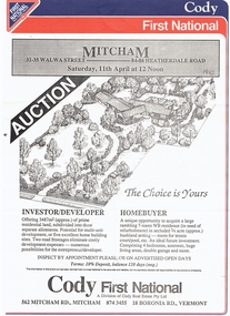
Document, Walwa Street, 1992
... Brochure for auction of three allotments bounded by 31 - 35 Walwa Street an 84 - 86 Heatherdale Road, Mitcham on 11 April 1992. Plan of 7 room house on site. Agent Cody First Nation....Whitehorse Historical Society Inc. 2-10 Deep Creek Road Mitcham melbourne auctions walwa street mitcham nos 31 - 35 heatherdale road nos 84 - 86 Brochure for auction of three allotments Brochure for auction of three allotments bounded by 31 - 35 Walwa Street an 84 - 86 Heatherdale Road, Mitcham on 11 April 1992. Plan of 7 room house on site. Agent Cody First Nation. ...Brochure for auction of three allotmentsBrochure for auction of three allotments bounded by 31 - 35 Walwa Street an 84 - 86 Heatherdale Road, Mitcham on 11 April 1992. Plan of 7 room house on site. Agent Cody First Nation.Brochure for auction of three allotmentsauctions, walwa street, mitcham, nos 31 - 35, heatherdale road, nos 84 - 86 -
Whitehorse Historical Society Inc.
Article, People before profit - land sale opponent, 1992
... Town planning City of Nunawading Burwood Highway Vermont South Livingstone Road Vermont South Vermont South A community group has criticised Nunawading Council's move to rezone and sell the Vermont South site it uses. ...A community group has criticised Nunawading Council's move to rezone and sell the Vermont South site it uses.A community group has criticised Nunawading Council's move to rezone and sell the Vermont South site it uses. The land is on the corner of Burwood Highway and Livingstone Road which is zoned D 'Public Open Space'. Council has deferred the decision to rezone until after a public meeting.A community group has criticised Nunawading Council's move to rezone and sell the Vermont South site it uses.town planning, city of nunawading, burwood highway, vermont south, livingstone road, vermont south, vermont south -
 Whitehorse Historical Society Inc.
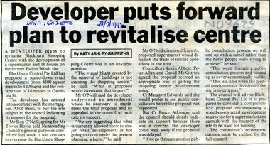
Article, Developer puts forward plan to revitalise centre, 1992
... A plan by developer Blackburn Central Pty Ltd proposing a scaled down retail development for Gardenia Street site....A plan by developer Blackburn Central Pty Ltd proposing a scaled down retail development for Gardenia Street site. ...A plan by developer Blackburn Central Pty Ltd proposing a scaled down retail development for Gardenia Street site.A plan by developer Blackburn Central Pty Ltd proposing a scaled down retail development for Gardenia Street site.A plan by developer Blackburn Central Pty Ltd proposing a scaled down retail development for Gardenia Street site.blackburn station shopping centre, blackburn central pty ltd -
Whitehorse Historical Society Inc.
Map, Schwerkolt historical homestead, 10/04/2002 12:00:00 AM
... Consists of master plan, details and site analysis, and accompanying letter, scale 1:500....Consists of master plan, details and site analysis, and accompanying letter, scale 1:500. ...Plans of Schwerkolt Cottage and Museum Complex.Plans of Schwerkolt Cottage and Museum Complex. Consists of master plan, details and site analysis, and accompanying letter, scale 1:500.Plans of Schwerkolt Cottage and Museum Complex. schwerkolt cottage & museum complex., plans -
Whitehorse Historical Society Inc.
Article, Vow to fight apartment building plan, 2007
... Mitcham Residents Association opposes demolition of Tudor-style house and cutting down of many trees on the site of 520 Mitcham Road. Vow to fight apartment building plan Article Article ...Mitcham Residents Association opposes demolition of Tudor-style house and cutting down of many trees on the site of 520 Mitcham Road.Mitcham Residents Association opposes demolition of Tudor-style house and cutting down of many trees on the site of 520 Mitcham Road.Mitcham Residents Association opposes demolition of Tudor-style house and cutting down of many trees on the site of 520 Mitcham Road.mitcham residents association, hogg, tony, chamberlain, david, mitcham road mitcham, no. 520 -
Whitehorse Historical Society Inc.
Document, Monier Wunderlich Tile Factory, 1989-96
... Papers concerning sub-division of the former Monier-Wunderlich Tile Factory site between Rooks and Mitcham Roads Vermont. Includes City of Nunawading planning documents and correspondence with residents; Wunderlich Residents' Action Group circulars; correspondence and drafts by W & B Gray relating to the proposals....Papers concerning sub-division of the former Monier-Wunderlich Tile Factory site between Rooks and Mitcham Roads Vermont. Includes City of Nunawading planning documents and correspondence with residents; Wunderlich Residents' Action Group circulars; correspondence and drafts by W & B Gray relating to the proposals. ...Papers concerning sub-division of the former Monier-Wunderlich Tile Factory site.Papers concerning sub-division of the former Monier-Wunderlich Tile Factory site between Rooks and Mitcham Roads Vermont. Includes City of Nunawading planning documents and correspondence with residents; Wunderlich Residents' Action Group circulars; correspondence and drafts by W & B Gray relating to the proposals.Papers concerning sub-division of the former Monier-Wunderlich Tile Factory site. wunderlich limited, monier-redlands pty ltd, mitcham road, mitcham, rooks road, vermont, nos. 147-157, wunderlich residents' action group, rosstrevor crescent, mitcham, redlands properties, gray, william, gray, beryl -
 Whitehorse Historical Society Inc.
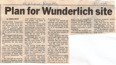
Article, Plan for Wunderlich site, 17/01/1996 12:00:00 AM
... Plan for Wunderlich site....Whitehorse Historical Society Inc. 2-10 Deep Creek Road Mitcham melbourne land subdivision redlands properties wunderlich limited mitcham road mitcham Wunderlich site in Mitcham Road, Article in Whitehorse Gazette re subdivision and rezoning of the former Wunderlich site in Mitcham Road, Mitcham. Plan for Wunderlich site. Article Article ...Wunderlich site in Mitcham Road,Article in Whitehorse Gazette re subdivision and rezoning of the former Wunderlich site in Mitcham Road, Mitcham.Wunderlich site in Mitcham Road,land subdivision, redlands properties, wunderlich limited, mitcham road, mitcham -
 Whitehorse Historical Society Inc.
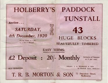
Pamphlet, Holberry's Paddock Tunstall, 1920
... Whitehorse Historical Society Inc. 2-10 Deep Creek Road Mitcham melbourne shady grove nunawading mount pleasant road holberry street t. r. b. morton & son auctions forest hill holberrys paddock tunstall Article on development of 30 lot subdivision of former Blackburn East Primary School Site Auction of Holberry's Paddock, Tunstall - 43 blocks, 4 December 1920. Includes plan. ...Article on development of 30 lot subdivision of former Blackburn East Primary School SiteAuction of Holberry's Paddock, Tunstall - 43 blocks, 4 December 1920. Includes plan.Article on development of 30 lot subdivision of former Blackburn East Primary School Siteshady grove, nunawading, mount pleasant road, holberry street, t. r. b. morton & son, auctions, forest hill holberrys paddock, tunstall -
Whitehorse Historical Society Inc.
Article - Newspaper cutting, Subdivision furore, 1994
... Vermont South Traders and residents are opposing Shell Australia's plans to subdivide a prominent Nunawading Council owned site on Burwood Highway for a 24 hour petrol station, McDonalds and Video library and cafe. ...Whitehorse Historical Society Inc. 2-10 Deep Creek Road Mitcham melbourne shops shell australia city of nunawading vermont south shopping centre burwood highway vermont south nos 473-493 Vermont South Traders and residents are opposing Shell Australia's plans to subdivide a prominent Nunawading Council owned site on Burwood Highway for a 24 hour petrol station, McDonalds and Video library and cafe. ...Vermont South Traders and residents are opposing Shell Australia's plans to subdivide a prominent Nunawading Council owned site on Burwood Highway for a 24 hour petrol station, McDonalds and Video library and cafe.Vermont South Traders and residents are opposing Shell Australia's plans to subdivide a prominent Nunawading Council owned site on Burwood Highway for a 24 hour petrol station, McDonalds and Video library and cafe. Objectors say it is a conflict of interest for the council as the sale of the land is conditional on council approving the subdivision.Vermont South Traders and residents are opposing Shell Australia's plans to subdivide a prominent Nunawading Council owned site on Burwood Highway for a 24 hour petrol station, McDonalds and Video library and cafe.shops, shell australia, city of nunawading, vermont south shopping centre, burwood highway, vermont south, nos 473-493 -
Whitehorse Historical Society Inc.
Article, Board agrees to Mitcham plan, 1962
... Mitcham's long range plan is to get the Education Department to agree to move the school to another site. ...Mitcham's long range plan is to get the Education Department to agree to move the school to another site. ...The Board of Works has agreed to Mitcham's proposal that the whole Mitcham Junior School area eventually should become a shopping car park.The Board of Works has agreed to Mitcham's proposal that the whole Mitcham Junior School area eventually should become a shopping car park. Mitcham's long range plan is to get the Education Department to agree to move the school to another site. This proposal first originated through Mitcham Chamber of Commerce, has already been before the State Government and the Education Department. The M.M.B.W. said it would not favour re-zoning to the east of Mitcham Road.The Board of Works has agreed to Mitcham's proposal that the whole Mitcham Junior School area eventually should become a shopping car park.shopping centres, mitcham shopping centre, melbourne and metropolitan board of works, mitcham chamber of commerce -
Whitehorse Historical Society Inc.
Document, Mount Pleasant School, c1868
... Photocopy of plan of schoolroom and site for Mount Pleasant School....Whitehorse Historical Society Inc. 2-10 Deep Creek Road Mitcham melbourne mount pleasant school no 1022 Photocopy of plan of schoolroom and site for Mount Pleasant School. ...Photocopy of plan of schoolroom and site for Mount Pleasant School.Photocopy of plan of schoolroom and site for Mount Pleasant School.Photocopy of plan of schoolroom and site for Mount Pleasant School.mount pleasant school, no 1022 -
Whitehorse Historical Society Inc.
Article, Plans To Consolidate Three Campuses, 21/09/1994 12:00:00 AM
... Article on the consolidation of Millauna Secondary Colleges, three campuses on to one site at Mitcham Road, due to operate in 1996. Plans To Consolidate Three Campuses Article Article ...Article on the consolidation of Millauna Secondary Colleges, three campuses on to one site at Mitcham Road, due to operate in 1996.Article on the consolidation of Millauna Secondary Colleges, three campuses on to one site at Mitcham Road, due to operate in 1996.Article on the consolidation of Millauna Secondary Colleges, three campuses on to one site at Mitcham Road, due to operate in 1996.secondary schools, millauna secondary college -
 Whitehorse Historical Society Inc.
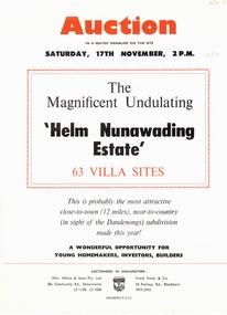
Document, Helm Nunawading Estate, 1957
... sites ' Helm Nunawading Estate', North East of Cnr Springvale Road and Springfield Road in Mitcham 17 November 1957. Auctioneers Wm. White & Sons, Frank Fisher & Co. Allotments sold for 400 pounds on high side of street, 350 pounds on lower side according to attached note by Bob Hirschfield in 1985. Includes plan...sites ' Helm Nunawading Estate', North East of Cnr Springvale Road and Springfield Road in Mitcham 17 November 1957. Auctioneers Wm. White & Sons, Frank Fisher & Co. Allotments sold for 400 pounds on high side of street, 350 pounds on lower side according to attached note by Bob Hirschfield in 1985. Includes plan ...Brochure advertising auction of 63 villa sitesBrochure advertising auction of 63 villa sites ' Helm Nunawading Estate', North East of Cnr Springvale Road and Springfield Road in Mitcham 17 November 1957. Auctioneers Wm. White & Sons, Frank Fisher & Co. Allotments sold for 400 pounds on high side of street, 350 pounds on lower side according to attached note by Bob Hirschfield in 1985. Includes plan of subdivision.Brochure advertising auction of 63 villa sites auctions, helm nunawading estate, olwen street, nunawading, efron street, springvale road, hirschfield, bob, william white and son, frank fisher & co.