Showing 4082 items matching " surveys"
-
 Bendigo Historical Society Inc.
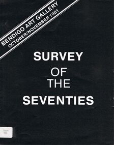
Book - SURVEY OF THE SEVENTIES
A booklet titled ' Survey of the Seventies.' Bendigo Art Gallery October/November 1981. An exhibition which 'has an overview of some aspects of Australian art in the 1970's.' Bottom left corner of front cover has a sticker and number 0125 PAT.artwork, exhibition, bendigo art gallery, exhibition, art, artwork, australian art, australian artists, artists, survey. bolttom left corner of front cover has number sticker 0125 pat. -
 Bendigo Historical Society Inc.
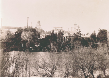
Photograph - OLD CHUM MINE, 1900's
Negative of view of Old Chum mine, taken from rear of Fortuna. Garden in foreground. Poppet head and chimneys in background. Inscriptions: 'Negative', 'Old Chum Mine from rear of Fortuna, probably early 1900's', 'per survey regiment'.topic, mining, old chum mine -
 Bendigo Historical Society Inc.
Map - SALISBURY : COUNTY OF BENDIGO, 1965
Map. Salisbury, County of Bendigo, Pompapiel, Yallook, Yarraberb, Yarrayne, Bullock Creek. Drawn and reproduced at the Department of Lands and Survey, Melbourne. Price $1.00. 1965. By authority A.C. Brooks, Government Printer, Melbourne. (number 28 in map cupboard 1)A.C. Brooks,Government Printer, Melbourne.map, bendigo, salisbury -
 Bendigo Historical Society Inc.
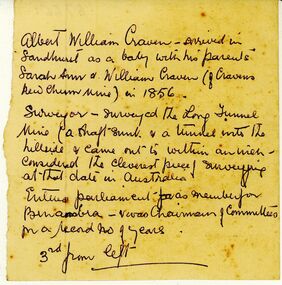
Document - ALBERT WILLIAM CRAVEN INFORMATION
Unknown author, handwritten notes pertaing to life of Albert William Craven. Craven of Cravens New Chum Mine in 1856. Surveyed the 'Long Tunnel Mine' [North/East Vic?] Entered parliament as member for Benambra. Notes pertained to lost photograph.gold mining, miners' safety cage, albert william craven. -
Bendigo Historical Society Inc.
Map - WARRAGAMBA : COUNTY OF BENDIGO, 29-4-30
Map. Warragamba, County of Bendigo, Pannoomilloo, Kamarooka, Minto, Diggorra. By authority H.J. Green, Government Printer. Piccaninny Creek. Drawn and reproduced at the Deparment of Lands and Survey, Melbourne. 29-3-30. Price2/-. (number 10 in map cupboard 1)H.J. Green, Government Printermap, bendigo, warragamba -
Bendigo Historical Society Inc.
Map - WANURP : COUNTY OF BENDIGO, 1-12-33
Map. Wanurp, County of Bendigo, Terrick Terrick East, Mitiamo, Milloo, Pannoobamawm. By authority H.J. Green, Government Printer.Photo-Lithographed at the Department of Lands and Survey, Melbourne. Price 2/-. 1-12-33. (number 9 in map cupboard 1)H.J. Green, Government Printermap, bendigo, wanurp -
Bendigo Historical Society Inc.
Map - TALAMBE : COUNTY OF BENDIGO, January 1956
Map. Talambe, County of Bendigo, Hayanmi, Pompapiel, Dingee, Tandarra, Yallook. By authority W.M. Houston, Government Printer, Melbourne. Drawn and reproduced at the Department of Lands and Survey, Melbourne. January 1956. Price 2/-. (number 8 in map cupboard 1)W.M. Houston, Government Printermap, bendigo, talambe -
Bendigo Historical Society Inc.
Map - SEDGWICK : COUNTY OF BENDIGO, 1963
Map. Sedgwick, County of Bendigo, Strathfieldsaye, Eppalock, Lyell, Mandurang, Sutton Grange. By Authority A.C. Brooks, Government Printer, Melbourne. Drawn and reproduced at the Deparment of Lands and Survey, Melbourne. 1963. Price 2/-. (number 7 in map cupboard 1)A.C. Brooks, Government Printer.map, bendigo, sedgwick -
Bendigo Historical Society Inc.
Map - SALISBURY : COUNTY OF BENDIGO, 1965
Map. Salisbury, County of Bendigo, Pompapiel, Yarrayne, Yarraberb, Yallook, Bullock Creek. By Authority: A.C. Brooks, Government Printer, Melbourne. Drawn and reproduced at the Department of Lands and Survey, Melbourne.1965. Price $1.00. (number 6 in map cupboard 1)A.C. Brooks, Government Printermap, bendigo, salisbury -
 Villa Alba Museum
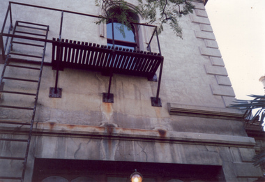
Photograph - Exterior wall including fire escape, c.1987
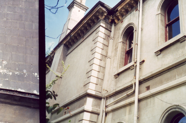
Built for William and Anna-Maria Greenlaw in the early 1880s, and with interiors decorated by the Paterson Bros, Villa Alba remained in private ownership until 1949. From 1950, the house was owned by a number of institutions. By 1984, the Villa Alba Preservation Society had been formed, and three years later, the Mount Royal Hospital granted a 25-year lease to Kew Council. In 2004, the title to Villa Alba was passed by the Victorian Government to The Villa Alba Museum Incorporated. The Museum, at 44 Walmer Street, Kew, is now a cultural institution committed to the collection, study and display of 19th century interior decorative finishes, and the components of 19th and 20th century interior decoration.This is one of a number of historically and aesthetically significant photos of the interiors and exterior of Villa Alba when it was still owned by the Mount Royal Hospital, showing twentieth century accretions and deterioration of the historic fabric of the building. This was a benchmark survey against which future conservation and restoration activities can be measured.In December 1987, Mockridge Stahle & Mitchell Pty Ltd Architects prepared ‘Villa Alba Survey: A Report on the fabric for Mount Royal Hospital’ of which this photograph is a part. Photo of exterior of Villa Alba showing exterior wall including fire escape.villa alba museum, conservation photographs, victorian architecture, cement render, fire escapes -
 Villa Alba Museum
Photograph - Exterior wall, c.1987
Built for William and Anna-Maria Greenlaw in the early 1880s, and with interiors decorated by the Paterson Bros, Villa Alba remained in private ownership until 1949. From 1950, the house was owned by a number of institutions. By 1984, the Villa Alba Preservation Society had been formed, and three years later, the Mount Royal Hospital granted a 25-year lease to Kew Council. In 2004, the title to Villa Alba was passed by the Victorian Government to The Villa Alba Museum Incorporated. The Museum, at 44 Walmer Street, Kew, is now a cultural institution committed to the collection, study and display of 19th century interior decorative finishes, and the components of 19th and 20th century interior decoration.This is one of a number of historically and aesthetically significant photos of the interiors and exterior of Villa Alba when it was still owned by the Mount Royal Hospital, showing twentieth century accretions and deterioration of the historic fabric of the building. This was a benchmark survey against which future conservation and restoration activities can be measured.In December 1987, Mockridge Stahle & Mitchell Pty Ltd Architects prepared ‘Villa Alba Survey: A Report on the fabric for Mount Royal Hospital’ of which this photograph is a part. Photo of exterior walls of Villa Alba with added building, later demolished, at left.villa alba museum, conservation photographs, victorian architecture, cement render -
 Bendigo Historical Society Inc.
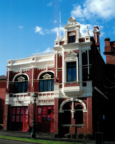
Document - Bendigo Fire Station View Street, 1960-1980s
In 1889 the three central fire brigades of Bendigo were amalgamated and a new fire station was erected in View Street (the third to be built on this site). This two storied brick building designed by Wm. Beebe forms an integral past of the View Street landscape. The red brick, white plaster relief trimmings and window frames with greenish lead-light decoration, all reflect the late Victorian style of the building. The ground floor contained an engine station and call room with stalls to accomodate three horses immediately behind. Upstairs in the main building is a handsome drill hall.Series of letters between Miss Starke and Miss Mathison re classification of the building by the National Trust; Letter to the Country Fire Authority (CFA) re classification; Media Release; National Trust data survey form; two photos of the fire stationhistory, national trust bendigo collection, bendigo, bendigo fire station -
 Bendigo Historical Society Inc.
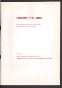
Document - MERLE HALL COLLECTION: ''HOUSING THE ARTS'' VOL 1 AUSTRALIA COUNCIL 1979
''Housing the Arts - Establishing Community Arts Centres or Performing Arts Facilities'' Vol 1 Australia Council 1979 . A guide for local councils and arts groups, based on the results of a survey of thirty centres throughout Australia. (Ross Thorne. 81 pages -
 Bendigo Military Museum
Flyer - Lansell's Fortuna - Flyer, Army Survey Regiment, Circa 1980
History of Fortuna Villa booklets were produced covering owners and occupiers, the building and the tours during Army tenure. A number of different versions of the Tour booklet were produced. Each version had a different colour cover. The orange covered edition of the booklet was the last version produced and printed and this flyer was produced as a handout companion for those tours. Contains a photograph of Fortuna Villa and a short history as well as location, cost, timings, other activities and booking information.The single page orange printed Flyer is for the Fortuna Tours conducted by the Army Survey Regiment. The Flyer has a photograph of Fortuna Villa taken from across the lake and is printed in orange on gloss paper. It contains a location diagram and details about the tours.royal australian survey corps, rasvy, fortuna, army survey regiment, army svy regt, asr -
 Bendigo Military Museum
Photograph - Army Survey Regiment – Commanding Officer Handover Parade, Fortuna, Bendigo, 1980
This photograph was taken at a Commanding Officer Handover Parade at the Army Survey Regiment, Bendigo in 1980. LTCOL Bob Skitch was the CO from 1976 to 1980 and handed over LTCOL Frank Thorogood SB St J. LTCOL Thorogood’s appointment was from 1980 to 1981.This is a set of 45 photographs taken at a Commanding Officer Handover Parade at the Army Survey Regiment, Bendigo in 1980. The photographs are on 35mm negative film and were scanned at 96 dpi. Photograph .34P is an enlargement printed on photographic paper and scanned at 300 dpi. They are part of the Army Survey Regiment’s Collection. .1) - Photo, black & white, 1980. Led by HQ Squadron, Army Survey Regiment marches onto the parade ground. .2) - Photo, black & white, 1980. Army Survey Regiment marches onto the parade ground. Drummers L to R: SSGT George Austen, CPL Di Chalmer, CPL Tony Lawler. .3) - Photo, black & white, 1980. Air Survey Squadron formed up. SSM WO1 Bob Mason at front. L to R: unidentified (x9), SPR Kristin (Isaac) Skidmore, unidentified, SPR Scheryl Delforce, unidentified (x2), SSGT Russell ‘Rusty’ Williams, SSGT Peter Warwick, SSGT Greg Buckenham, SGT Cliff Webb, SSGT Alan Derby, SSGT John Bennett, SSGT Bruce Gordon. .4) - Photo, black & white, 1980. Officers formed up before taking posts. L to R: CAPT Peter Searle - UK Exchange, unidentified, LT Ozzy Slade, CAPT Peter ‘Blue’ Blaskett, unidentified (x4), CAPT Bob Williams, MAJ David Bowen - US Exchange officer, unidentified (x3), RSM WO1 Aub Harvey. .5) - Photo, black & white, 1980. Officers salute before taking posts. L to R: CAPT Peter Searle - UK Exchange, unidentified, LT Ozzy Slade, CAPT Peter ‘Blue’ Blaskett, unidentified (x4), CAPT Bob Williams, MAJ David Bowen - US Exchange officer, unidentified (x3). .6) - Photo, black & white, 1980. Officers march to their posts. L to R: CAPT Bob Cooper, CAPT Mick Byrne, MAJ Robin Blackburn, unidentified. .7) & .8) - Photo, black & white, 1980. L to R: 2IC MAJ Don Swiney MBE hands over parade to CO LTCOL Bob Skitch. Cartographic Squadron - Centre rank L to R: CPL Paul Richards, SPR Megan (McBurney) Reynolds, SPR Jan (Crighton) Minchin, SPR Ilen Isaac, CPL Lynn Johnson, remainder unidentified. Front rank L to R: CPL Dennis Learmonth, CPL Roger Pearson, SPR Rod Skidmore, SPR John Martin, SGT Bob Bright, CPL Trevor Bottomley, SPR Gerry Gates, remainder unidentified, OC CAPT Bob Williams, Officer in far right: CAPT Bob Cooper. .9) - Photo, black & white, 1980. L to R: CO LTCOL Bob Skitch salutes reviewing officer - Commander 3MD BRIG Geoffrey Cohen AM. Cartographic Squadron in background L to R: CPL Trevor Bottomley, SPR Gerry Gates, SPR Peter Main, CPL John ‘Stormy’ Tempest, unidentified, OC CAPT Bob Williams, SSGT Gary Warnest. .10) - Photo, black & white, 1980. HQ Squadron inspection - L to R: unidentified (x5), CAPT Paddy Strunks, SPR Chris Ebeling, CO LTCOL Bob Skitch, BRIG Geoffrey Cohen AM, unidentified (x7), in foreground MAJ David Bowen - US Exchange officer, unidentified, CPL Phil McGuire, WO2 Ted Burgess. .11) - Photo, black & white, 1980. HQ Squadron in foreground L to R: MAJ David Bowen - US Exchange officer, unidentified, CPL Phil McGuire, WO2 Ted Burgess. Lithographic Squadron inspection L to R: CPL Paul Davis, CPL Le-Anne (Smallshaw) Shirely, CO LTCOL Bob Skitch, unidentified, OC MAJ Robin Blackburn, BRIG Geoffrey Cohen AM, SPR Jim Ash, unidentified, unidentified UK Exchange SNCO, SSGT Greg Francis-Wright, WO1 Doug Malligan, drummers SSGT George Austen, CPL Di Chalmer, CPL Tony Lawler, unidentified (x2). .12) - Photo, black & white, 1980. Air Survey Squadron inspection - L to R: LT Ozzy Slade, CAPT Peter ‘Blue’ Blaskett, unidentified officer, front rank L to R: SGT Cliff Webb, CO LTCOL Bob Skitch, CAPT Peter Searle - UK Exchange, unidentified, centre rank L to R: unidentified, SSGT Greg Buckingham, SSGT John Bennett, rear rank L to R: unidentified (x4), SPR Sharon (Jones) Treble, CPL Marrianne (Van De Zee) De Groot, SPR Ginny (Turner) Rowe, SSGT Kevin Kennedy, unidentified, SSGT Alan Derby. .13) - Photo, black & white, 1980. Air Survey Squadron inspection - Centre rank: SSGT John Bennett, CO LTCOL Bob Skitch, CAPT Peter Searle - UK Exchange, BRIG Geoffrey Cohen AM, rear rank L to R: SPR Ginny (Turner) Rowe, SSGT Kevin Kennedy, unidentified, SSGT Alan Derby, SSGT Bruce Gordon, supernumerary rank L to R: SSM WO1 Bob Mason, WO1 Bob Hayden, WO2 Peter Colwell, WO1 Chris Parkinson. Unidentified. .14) - Photo, black & white, 1980. Air Survey Squadron inspection - Centre rank: SSGT John Bennett, CO LTCOL Bob Skitch, CAPT Peter Searle - UK Exchange, BRIG Geoffrey Cohen AM, rear rank L to R: SPR Ginny (Turner) Rowe, SSGT Kevin Kennedy, unidentified, SSGT Alan Derby, SSGT Bruce Gordon, supernumerary rank L to R: SSM WO1 Bob Mason, WO1 Bob Hayden, WO2 Peter Colwell. .15) - Photo, black & white, 1980. Cartographic Squadron inspection – L to R: OC CAPT Bob Williams, CO LTCOL Bob Skitch, BRIG Geoffrey Cohen AM. Front rank L to R: CPL John ‘Stormy’ Tempest, unidentified (x2), SSGT Allan Adsett, SSGT Gary Warnest. Centre rank L to R: SPR Ilen Isaac, CPL Sue (Fryer) Bottomley, SPR Gina (Coore) Neilson, SPR Carla Dell, CPL Lynn Johnson, SPR Cathy Regan, unidentified, SSGT John ‘JB’ Barrie, SSGT Bob Scaddan. Rear rank L to R: CPL Terry Danger, CPL Brad Peppler. .16) & .17) - Photo, black & white, 1980. Cartographic Squadron inspection – L to R: OC CAPT Bob Williams, CO LTCOL Bob Skitch, BRIG Geoffrey Cohen AM. Front rank L to R: CPL Dennis Learmonth, CPL Roger Pearson, SPR Rod Skidmore, SPR John Martin, SGT Bob Bright, CPL Trevor Bottomley, SPR Gerry Gates, CPL John ‘Stormy’ Tempest, unidentified (x2), SSGT Allan Adsett, SSGT Gary Warnest. CO LTCOL Bob Skitch, CAPT Bob Cooper, BRIG Geoffrey Cohen AM. Centre rank L to R: SPR Ilen Isaac, CPL Sue (Fryer) Bottomley, SPR Gina (Coore) Neilson, SPR Carla Dell, SPR Cathy Regan, SSGT John ‘JB’ Barrie, SSGT Bob Scaddan. Rear rank L to R: CPL Terry Danger, CPL Brad Peppler, SGT Stu Thaxter, SGT Colin Cuskelly, SGT Bill Friswell. Far right: CAPT Peter Searle - UK Exchange, WO1 Jim ‘JJJ’ Jefferies. .18) - Photo, black & white, 1980. Cartographic Squadron inspection – Front rank: SSGT Gary Warnest. L to R: CO LTCOL Bob Skitch, CAPT Bob Cooper, BRIG Geoffrey Cohen AM. Centre rank L to R: SPR Ilen Isaac, CPL Sue (Fryer) Bottomley, SPR Gina (Coore) Neilson, SPR Carla Dell, SPR Cathy Regan, SSGT John ‘JB’ Barrie, SSGT Bob Scaddan. Rear rank L to R: CPL Terry Danger, CPL Brad Peppler, SGT Stu Thaxter, SGT Colin Cuskelly, SGT Bill Friswell. SSM WO1 Gordon Lowery. Far right: WO1 Jim ‘JJJ’ Jefferies, CAPT Peter Searle - UK Exchange, CAPT Peter ‘Blue’ Blaskett, LT Ozzy Slade. .19) - Photo, black & white, 1980. Medal presentation - L to R: CO LTCOL Bob Skitch, CAPT Bob Cooper. Cartographic Squadron – Front rank L to R: CPL Dennis Learmonth, CPL Roger Pearson, SPR Rod Skidmore, SGT Bob Bright, CPL Trevor Bottomley, SPR Gerry Gates, SPR Peter Main, CPL John ‘Stormy’ Tempest. Centre rank L to R: CPL Paul Richards, SPR Jan (Crighton) Minchin, SPR Ilen Isaac, SPR Carla Dell, CPL Lynn Johnson, SPR Cathy Regan. .20) - Photo, black & white, 1980. Medal presentation - L to R: CAPT Bob Cooper, BRIG Geoffrey Cohen AM. Cartographic Squadron – Front rank L to R: CPL Dennis Learmonth, CPL Roger Pearson, SPR Rod Skidmore, SPR John Martin, SGT Bob Bright, SPR Peter Main, CPL John ‘Stormy’ Tempest, SSGT Allan Adsett, SSGT Gary Warnest. Centre rank L to R: CPL Paul Richards, SPR Jan (Crighton) Minchin, SPR Ilen Isaac, CPL Sue (Fryer) Bottomley, SPR Gina (Coore) Neilson. .21) - Photo, black & white, 1980. Medal presentation - L to R: CAPT Bob Cooper, BRIG Geoffrey Cohen AM. Cartographic Squadron – Front rank L to R: CPL Dennis Learmonth, CPL Roger Pearson, SPR Rod Skidmore, SPR John Martin, SGT Bob Bright, SPR Peter Main, CPL John ‘Stormy’ Tempest, SSGT Gary Warnest. Centre rank L to R: CPL Paul Richards, SPR Jan (Crighton) Minchin, SPR Ilen Isaac, CPL Sue (Fryer) Bottomley. .22) - Photo, black & white, 1980. Medal presentation - L to R: CO LTCOL Bob Skitch, CAPT Bob Cooper, BRIG Geoffrey Cohen AM. Cartographic Squadron – Front rank L to R: CPL Dennis Learmonth, CPL Roger Pearson, SPR Rod Skidmore, SPR John Martin, SGT Bob Bright CPL Trevor Bottomley, SPR Gerry Gates, SPR Peter Main, CPL John ‘Stormy’ Tempest, CAPT Bob Williams, SSGT Allan Adsett. Centre rank L to R: CPL Paul Richards, SPR Jan (Crighton) Minchin, SPR Gina (Coore) Neilson, SPR Carla Dell, CPL Lynn Johnson, SPR Cathy Regan, unidentified, SSGT Bob Scaddan. Rear rank: CPL Stu Symonds. .23) - Photo, black & white, 1980. Presentation - L to R: CO LTCOL Bob Skitch, BRIG Geoffrey Cohen AM, ADJT CAPT John Harrison. Cartographic Squadron – Front rank L to R: CPL Dennis Learmonth, CPL Roger Pearson, SPR Rod Skidmore, SPR John Martin, SGT Bob Bright CPL Trevor Bottomley, SPR Gerry Gates, unidentified, CAPT Bob Williams, SSGT Allan Adsett, CAPT Bob Cooper. Centre rank L to R: SPR Jan (Crighton) Minchin, CPL Sue (Fryer) Bottomley, SPR Carla Dell, CPL Lynn Johnson, SPR Cathy Regan, unidentified, SSGT Bob Scaddan. .24) - Photo, black & white, 1980. Presentation - L to R: CO LTCOL Bob Skitch, BRIG Geoffrey Cohen AM, ADJT CAPT John Harrison. Cartographic Squadron – Front rank L to R: SPR Rod Skidmore, SPR John Martin, SGT Bob Bright CPL Trevor Bottomley, SPR Gerry Gates, unidentified, CAPT Bob Williams, CAPT Bob Cooper. Centre rank L to R: SPR Jan (Crighton) Minchin, CPL Sue (Fryer) Bottomley, SPR Carla Dell, CPL Lynn Johnson, SPR Cathy Regan, unidentified, SSGT Bob Scaddan. .25) - Photo, black & white, 1980. Presentation - L to R: CO LTCOL Bob Skitch, BRIG Geoffrey Cohen AM, ADJT CAPT John Harrison. Cartographic Squadron – Front rank L to R: CPL Roger Pearson, SPR Rod Skidmore, SPR John Martin, SGT Bob Bright CPL Trevor Bottomley, unidentified, CAPT Bob Williams, SSGT Allan Adsett, SSGT Gary Warnest. CAPT Bob Cooper, Centre rank L to R: CPL Sue (Fryer) Bottomley, SPR Gina (Coore) Neilson, SPR Carla Dell, CPL Lynn Johnson. .26) to .28) - Photo, black & white, 1980. Presentation - L to R: MAJ Robin Blackburn, BRIG Geoffrey Cohen AM, ADJT CAPT John Harrison. .29) to .31) - Photo, black & white, 1980. Presentation - L to R: SPR Penny Knott, CO LTCOL Bob Skitch. .32) - Photo, black & white, 1980. CO Handover - L to R: LTCOL Bob Skitch, LTCOL Frank Thorogood SB St J. Cartographic Squadron – Front rank L to R: CPL Dennis Learmonth, CPL Roger Pearson, SPR Rod Skidmore, SPR John Martin SPR Gerry Gates, SPR Peter Main, CPL John ‘Stormy’ Tempest, unidentified, CAPT Bob Williams, SSGT Allan Adsett, SSGT Gary Warnest. Centre rank L to R: SPR Ilan Isaac, CPL Sue (Fryer) Bottomley, SPR Gina (Coore) Neilson, SSGT Bob Scaddan at end. .33) & .34) - Photo, black & white, 1980. CO Handover - L to R: LTCOL Bob Skitch, LTCOL Frank Thorogood SB St J. Cartographic Squadron – Front rank L to R: CPL Dennis Learmonth, CPL Roger Pearson, SPR Rod Skidmore, SPR John Martin, SGT Bob Bright, SPR Gerry Gates, SPR Peter Main, CPL John ‘Stormy’ Tempest, unidentified, CAPT Bob Williams, SSGT Allan Adsett. Centre rank L to R: SPR Ilen Isaac, CPL Sue (Fryer) Bottomley, SPR Gina (Coore) Neilson, SSGT Bob Scaddan at end. .35) - Photo, black & white, 1980. CO Handover – March past L to R: BRIG Geoffrey Cohen AM, ADJT CAPT John Harrison. LTCOL Frank Thorogood SB St J, CO LTCOL Bob Skitch. L to R: RSM WO1 Aub Harvey, 2IC MAJ Don Swiney MBE. .36) - Photo, black & white, 1980. CO Handover March past L to R: BRIG Geoffrey Cohen AM, ADJT CAPT John Harrison. LTCOL Frank Thorogood SB St J, CO LTCOL Bob Skitch. HQ Squadron march past L to R: unidentified officer, MAJ MAJ David Bowen - US Exchange officer, CAPT Paddy Strunks. .37) - Photo, black & white, 1980. CO Handover March past L to R: BRIG Geoffrey Cohen AM, ADJT CAPT John Harrison. LTCOL Frank Thorogood SB St J, CO LTCOL Bob Skitch. HQ Squadron march past L to R: unidentified, SGT Rick Warren, remainder unidentified. .38) - Photo, black & white, 1980. CO Handover March past L to R: BRIG Geoffrey Cohen AM, ADJT CAPT John Harrison. LTCOL Frank Thorogood SB St J, CO LTCOL Bob Skitch. Cartographic Squadron march past L to R: CLP Paul Richards, CPL Dennis Learmonth, CAPT Bob Williams, CAPT Bob Cooper. .39) - Photo, black & white, 1980. CO Handover March past L to R: BRIG Geoffrey Cohen AM, ADJT CAPT John Harrison. LTCOL Frank Thorogood SB St J, CO LTCOL Bob Skitch. Cartographic Squadron march past L to R: SPR Greg Else, SPR Jan (Crighton) Minchin, SPR Rod Skidmore, unidentified, SPR Megan (McBurney) Reynolds, CPL Roger Pearson, CPL Stu Symonds, CPL Paul Richards. .40) - Photo, black & white, 1980. CO Handover March past L to R: BRIG Geoffrey Cohen AM, ADJT CAPT John Harrison. LTCOL Frank Thorogood SB St J, CO LTCOL Bob Skitch. Cartographic Squadron march past L to R: CPL Terry Danger, CPL Lynn Johnson, SPR Peter Main, unidentified, SPR Carla Dell, SPR Gerry Gates, SPR Bob Sheppard, SPR Gina (Coore) Neilson, CPL Trevor Bottomley, SPR Ian Fitzgerald, CPL Sue (Fryer) Bottomley, unidentified. .41) - Photo, black & white, 1980. CO Handover March past L to R: BRIG Geoffrey Cohen AM, ADJT CAPT John Harrison. LTCOL Frank Thorogood SB St J, CO LTCOL Bob Skitch. Lithographic Squadron march past L to R: CAPT Mick Byrne, MAJ Robin Blackburn. .42) - Photo, black & white, 1980. CO Handover March past L to R: BRIG Geoffrey Cohen AM, ADJT CAPT John Harrison. LTCOL Frank Thorogood SB St J, CO LTCOL Bob Skitch. Lithographic Squadron march past L to R: CPL Gary Kerr, SPR Brian Paul, SPR Brian Fauth, CPL Roy Hicks, SPR Per Andersen, CAPT Mick Byrne. .43) & .44) - Photo, black & white, 1980. CO Handover March past L to R: BRIG Geoffrey Cohen AM, ADJT CAPT John Harrison. LTCOL Frank Thorogood SB St J, CO LTCOL Bob Skitch. Lithographic Squadron march past. .45) - Photo, black & white, 1980. CO Handover March past L to R: BRIG Geoffrey Cohen AM, ADJT CAPT John Harrison. LTCOL Frank Thorogood SB St J, CO LTCOL Bob Skitch. Officer march past L to R: unidentified, CAPT Peter Searle - UK Exchange.No personnel are identified. Photo .34P is annotated on back ‘1981 LTCOL Bob Skitch handed over to LTCOL Thorogood.’ *Date is incorrect.royal australian survey corps, rasvy, army survey regiment, army svy regt, fortuna, asr -
 Melbourne Tram Museum
Document - Research Notes, H. S. McComb, Victoria Parade to Victoria Bridge line, c1930
... Surveys ...Notes 4 pages, pinned together, giving details, opening dates, terminals, depot entries, sheave pits, curves, for the Victoria Parade to Victoria Bridge line. Items 2064 to 2075 within box 72.3 in a brown folder marked "MT&O Co." red pencil on the front cover.trams, tramways, mto co, cable trams, drawings, reports, surveys, victoria parade, victoria st -
 Melbourne Tram Museum
Document - Research Notes, H. S. McComb, Hamilton, "Synopsis of Cost of the Melbourne Tramway System", 1896
... Surveys ...Single sheet, folded into half, typed, with pencil notation on the front "Hamilton's cable figures" providing a "Synopsis of Cost of the Melbourne Tramway System", prepared for The Melbourne Tramways Trust by its Secretary and Engineer T. Hamilton, dated December 1896. Provides length of each line, cost of track, cost of altering services, engine houses, engineer, general expenses and cost per mile. Also includes horse tramways, staff, offices, borrowings. Items 2064 to 2075 within box 72.3 in a brown folder marked "MT&O Co." red pencil on the front cover.trams, tramways, mto co, cable trams, drawings, reports, surveys, horse trams, mtt -
 Melbourne Tram Museum
Document - Research Notes, H. S. McComb, development and timing of the "PMTT" - part 1, 1950's
... Surveys ...Set of papers, handwritten concerning the development and timing of the "PMTT", Prahran and Malvern - about 13 sheets. Prepared by H. S. McComb - gives layout of the PMTT system, sketches of track layout, opening dates, sketches of various junctions, bridges, track miles, junctions, reconciliations of track lengths from various sources, Camberwell Junction and cross overs. Items 2041 to 2052 within box 72.3 in a brown folder marked "PMTT" in red pencil.trams, tramways, pmtt, malvern, routes, track, malvern depot, camberwell junction, surveys -
 Melbourne Tram Museum
Document - Report, Melbourne & Metropolitan Tramways Board (MMTB), "Comparison between service requirements using two bogie trams and a mixed fleet of three bogie articulated trams and two bogie trams.", Sep. 1965
... Surveys ....1 - Report Foolscap 6 typed pages, multiple diagrams and tables (some on heat sensitive paper) with card covers, with red binding strips, titled "Comparison between service requirements using two bogie trams and a mixed fleet of three bogie articulated trams and two bogie trams for Kew Depot routes", dated June 1965. Includes diagrams of passengers each hour for multiple stops. Concludes that crew and tram savings would be in excess of 20%. Report - Foolscap 6 typed pages, multiple diagrams and tables (some on heat sensitive paper) with card covers, with red binding strips, titled "East Preston depot routes - comparison between service requirements using two bogie trams and a mixed fleet of three bogie articulated trams and two bogie trams" Dated September 1965. Includes diagrams of passengers each hour for multiple stops. Concludes that for the East Preston route, a 20% saving in crews. Brunswick route would not applicable.In top left hand corner "Lees" in penciltrams, tramways, mmtb, tramways, speed of services, articulated trams, surveys, east preston depot, kew depot -
 Melbourne Tram Museum
Document - Report, Melbourne & Metropolitan Tramways Board (MMTB), "Passenger movements by public transport for the Central city Business area based on results of the 1964 Melbourne Metropolitan Transportation Study, Nov. 1965
... Surveys ...Report - Foolscap landscape format, red tape binding - approx. 80 pages with notes, diagrams, charts, maps showing passenger traffic for parts of each route, including Railway Stations, passenger flows, titled "Passenger movements by public transport for the Central city Business area based on results of the 1964 Melbourne Metropolitan Transportation Study.In top right hand corner "Lees" in inktrams, tramways, mmtb, tramways, melbourne, surveys, passengers, railways, maps -
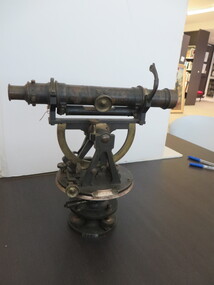 Federation University Historical Collection
Scientific Instrument, Theodolite: Early 1900s, c1860
The theodolite is used in surveying and measures vertical and horizontal angles. Placed on a tripod, it is used to find angles in road building, tunnel alignment and other civil-engineering work. The theodolite was used at Ballarat School of Mines in the surveying course. It is possible that this instrument was imported by Flavelle Bros & Co having been made to their order by a European instrument makerTheodolite (without a matching tripod) with four leveling screws at the base. Telescope not fully rotatable, ends can be interchanged. Underslung levelling bubbletheodolite, surveying, european instrument, importers, ballarat school of mines, flavelle bros & co, measuring angles, road building, civil engineering -
 Bendigo Military Museum
Photograph - Flag Day - Army Survey Regiment Verses School of Military Survey, Latchford Barracks, Bonegilla, 1990
These 34 photographs were taken at Flag Day, an annual sports competition between the Army Survey Regiment and the School of Military Survey (SMS) at Latchford Barracks, Bonegilla in May 1990. The two RASvy units took turns each year to host the event. The day competition usually comprised basketball, cross country, golf, sailing, squash softball, tennis, touch football, tug-of-war and volleyball. The evening competition often included darts, carpet bowls, hookey, quoits and snooker. The Flag handover and speeches were held in SMS’s Café Slater recreation/morning tea area. It is not clear which RA Svy unit was the winner.This is a set of 34 photographs were taken at Flag Day, an annual sports competition between the Army Survey Regiment (ASR) and the School of Military Survey (SMS) at Latchford Barracks, Bonegilla in May 1990. There are more photographs available on colour negatives and 35mm positive proofs. The photo proofs were printed on photographic paper and are part of the Army Survey Regiment’s Collection. The 35mm colour negatives photographs were scanned at 96 dpi. .1) - Photo, colour, 1990, ASR Tug-of-war team. Back row L to R: unidentified, Geoff Ford, Ken Slater, unidentified, Anthony Hesling. Front row L to R: Mick Hogan, Mick Duggan, Damien Killeen, unidentified, Guenther Ebenwaldner. .2) - Photo, colour, 1990, ASR Tug-of-war team. L to R: Geoff Ford, unidentified (x2). .3) - Photo, colour, 1990, ASR volleyball team L to R: unidentified (x4), Phuc Tran, Guenther Ebenwaldner, unidentified (x4), Neil Taylor. .4) - Photo, colour, 1990, ASR volleyball team L to R: unidentified (x2), Neil Taylor. .5) - Photo, colour, 1990, ASR volleyball team L to R: unidentified, Phuc Tran, Guenther Ebenwaldner, Barry Hogan -spiking. SMS volleyball team L to R: unidentified (x2), Rod Skidmore, unidentified (x2). .6) - Photo, colour, 1990, ASR volleyball team Neil Taylor – serving, L to R: unidentified, Guenther Ebenwaldner, unidentified. .7) - Photo, colour, 1990, ASR volleyball team Phuc Tran – serving. .8) - Photo, colour, 1990, ASR volleyball team unidentified – serving. .9) - Photo, colour, 1990, ASR volleyball team L to R: Guenther Ebenwaldner – serving, unidentified. .10) - Photo, colour, 1990, L to R: SMS volleyball team, all unidentified. ASR volleyball team L to R: Greg Howell, Richard Arman, Rachel (Stanford) Scott, SPR Caroline (Wyatt) Evans, Tracy Tillman, unidentified SMS team member. .11) - Photo, colour, 1990, L to R: ASR volleyball team L to R: Neil Taylor, Guenther Ebenwaldner, unidentified (x2), Tracy Tillman – No.13, Barry Hogan – No.1, Richard Arman, Greg Howell, SPR Rachel (Stanford) Scott, SPR Caroline (Wyatt) Evans. .12) - Photo, colour, 1990, L to R: Bob Thrower, Rod Skidmore – No.5, unidentified referee, Guenther Ebenwaldner, Neil Taylor. .13) - Photo, colour, 1990, L to R: unidentified (x2), Rod Skidmore – No.5, unidentified, unidentified referee, unidentified, Guenther Ebenwaldner – No.2, Phuc Tran - No.8, Neil Taylor - No.9., .14) - Photo, colour, 1990, L to R: unidentified – serving, Neil Taylor. .15) - Photo, colour, 1990, L to R: unidentified (x2), Bob Thrower – No. 2, unidentified referee, Phuc Tran, unidentified, Barry Hogan – No.1, Guenther Ebenwaldner – No.2, unidentified. .16) - Photo, colour, 1990, L to R: unidentified, unidentified referee, unidentified, Neil Taylor - No.9, Guenther Ebenwaldner – No.2, unidentified. .17) - Photo, colour, 1990, L to R: Tracy Tillman, SPR Rachel (Stanford) Scott, SPR Caroline (Wyatt) Evans, Phuc Tran. .18) - Photo, colour, 1990, L to R: Guenther Ebenwaldner – serving, Barry Hogan. .19) - Photo, colour, 1990, L to R: unidentified – serving, unidentified. .20) - Photo, colour, 1990, ASR volleyball team L to R: unidentified, Guenther Ebenwaldner, SPR Caroline (Wyatt) Evans – No. 20, unidentified (x2), Richard Arman No.11, unidentified, Barry Hogan – No.1, Tracy Tillman – No.13, Neil Taylor, Rachel (Stanford) Scott, Phuc Tran. .21) - Photo, colour, 1990, SMS volleyball team, L to R: Rod Skidmore Bob Thrower, remainder unidentified. ASR volleyball team L to R: unidentified, Rachel (Stanford) Scott, Barry Hogan, Greg Howell, unidentified, Guenther Ebenwaldner, unidentified, Phuc Tran, Neil Taylor, Richard Arman. .22) - Photo, colour, 1990, SMS volleyball team, L to R: unidentified Rod Skidmore – No. 5, Bob Thrower, remainder unidentified. .23) - Photo, colour, 1990, ASR basketball team, L to R: unidentified (x3), Dave Longbottom. .24) & .25) - Photo, colour, 1990, Presentations. L to R: CAPT Brian Sloan, ASR RSM WO1 Neville Stone, SPR Frank Savy, WO2 Neil ‘Ned’ Kelly. .26) - Photo, colour, 1990, Presentations. L to R: CAPT Brian Sloan, ASR RSM WO1 Neville Stone, SPR Frank Savy, SPR Marcus Seecamp, WO2 Neil ‘Ned’ Kelly, SMS RSM WO1 Greg Francis-Wright, remainder unidentified. .27) - Photo, colour, 1990, Presentations. L to R: SPR Frank Savy, SPR Andrew Morrison-Evans – with flag, unidentified, SPR Derek Percival– with flag, SPR Dawn Hoadley, ASR CO LTCOL Rene van den Tol, CAPT Brian Sloan, ASR RSM WO1 Neville Stone, unidentified. .28) - Photo, colour, 1990, Presentations. L to R: ASR CO LTCOL Rene van den Tol, unidentified, SPR Derek Percival– with flag, SPR Dawn Hoadley, unidentified, ASR RSM WO1 Neville Stone, SMS CO LTCOL Harry Hansen. .29) - Photo, colour, 1990, Presentations. L to R: ASR CO LTCOL Rene van den Tol, SMS CO LTCOL Harry Hansen, SPR Dawn Hoadley, ASR RSM WO1 Neville Stone, unidentified, SGT Ian Fitzgerald, WO2 Tony Clark, WO2 Harald Mai. .30) - Photo, colour, 1990, Presentations. L to R: unidentified, SPR Derek Percival, ASR CO LTCOL Rene van den Tol, ASR RSM WO1 Neville Stone, SMS CO LTCOL Harry Hansen, CPL Kevin ‘Chuck’ Berry, SGT Ian Fitzgerald, WO2 Tony Clark, WO2 Harald Mai, unidentified. .31) - Photo, colour, 1990, Presentations. L to R: SPR Marcus Seecamp, SPR Dawn Hoadley, ASR CO LTCOL Rene van den Tol, unidentified, SMS CO LTCOL Harry Hansen, CPL Kevin ‘Chuck’ Berry, ASR RSM WO1 Neville Stone, SMS RSM WO1 Greg Francis-Wright, SGT Ian Fitzgerald. .32) - Photo, colour, 1990, Presentations. L to R: SPR Dawn Hoadley, ASR CO LTCOL Rene van den Tol, unidentified, SMS CO LTCOL Harry Hansen, ASR RSM WO1 Neville Stone, SMS RSM WO1 Greg Francis-Wright, SGT Ian Fitzgerald, CPL Barry Hogan, remainder unidentified. .33) - Photo, colour, 1990, Presentations. Those identified L to R: CPL Raelene Munting, CPL Peter Swandale, SGT Paul Baker, WO1 Gordon Lowery, SPR Caroline (Wyatt) Evans, SMS CO LTCOL Harry Hansen, WO2 Alan Glanville, CPL Michelle Griffith, SGT Peter Peterson, WO1 Russell ‘Rusty’ Williams, WO1 Colin Cuskelly, CPL Peter McCurdy, WO2 Steve Egan, SSGT Doug Carswell, WO1 Bill Jones, WO2 Rob Bogumil, SPR Andrew Morrison-Evans. .34) - Photo, colour, 1990, Presentations. Those identified L to R: SMS CO LTCOL Harry Hansen, SPR Anthony Hesling CPL Peter Swandale, SGT Paul Baker, CPL Tony Bestall, SPR Shane ‘Smily’ Campbell. .1P to .36P – no annotationsroyal australian survey corps, rasvy, army survey regiment, army svy regt, fortuna, asr, flag day, school of military survey -
 Bendigo Military Museum
Photograph - 4th Field Survey Squadron Soccer Match. Adelaide, SA, 1994
This is a selection of 30 photographs of 4th Field Survey Squadron personnel participating in a soccer game, between the Other Ranks (ORs) and Officers/Warrant Officers/Senior Non-Commissioned Officers (OFFR/SNCOs), at an unknown location in Adelaide, South Australia on the 28th of October 1994.This is a selection of 30 photographs of 4th Field Survey Squadron personnel participating in a soccer game at an unknown location in Adelaide, South Australia on the 28th of October 1994. The colour photographs are part of a set of 72 photographs on 35mm negative film and are part of the Army Survey Regiment’s Collection. The photographs were scanned at 96 dpi. .1) - Photo, colour, 1994. OFFR/SNCOs L to R: SSGT A. Simcock. WO2 Peter Hammer, SGT Peter Hardy, unidentified, SSGT Brian Collings, unidentified, WO2 Simon ‘Andy’ Capp, SGT H. Evertz, OC MAJ Peter Demaine, unidentified, CAPT Chris Topovsek. .2) - Photo, colour, 1994. ORs L to R: unidentified (x3), CPL Steve Wegener, CPL Dick Crawford, unidentified, LCPL Mitch Oake, unidentified. .3) - Photo, colour, 1994. L to R: CAPT Chris Topovsek, SGT Steve McGuiness, LCPL Mitch Oake, WO2 Simon ‘Andy’ Capp, unidentified. .4) - Photo, colour, 1994. L to R: unidentified, CPL Steve Wegener. .5) - Photo, colour, 1994. L to R: WO2 Simon ‘Andy’ Capp, SSGT Pat ‘Fuji’ Drover, unidentified. .6) - Photo, colour, 1994. L to R: unidentified (x2). .7) - Photo, colour, 1994. L to R: SSGT A. Simcock, SPR Mark Linwood, SPR Mark McInerney, unidentified, CPL Dick Crawford. .8) - Photo, colour, 1994. CPL Dick Crawford. .9) - Photo, colour, 1994. L to R: unidentified, SGT Steve McGuiness, SPR Mark Linwood, SPR Mark McInerney, SSGT A. Simcock. .10) - Photo, colour, 1994. CPL Dick Crawford taking an indirect penalty. The wall L to R: SGT H. Evertz, WO2 Simon ‘Andy’ Capp, SSGT Pat ‘Fuji’ Drover, SGT Dave Longbottom. .11) - Photo, colour, 1994. OFFR/SNCOs half time L to R: OC MAJ Peter Demaine, unidentified, SGT Dave Longbottom, SSGT A. Simcock, unidentified, SGT Steve McGuiness, unidentified, WO2 Peter Hammer. .12) - Photo, colour, 1994. ORs half time L to R: unidentified, SPR Mark Linwood, CPL Peter Ball, CPL Steve Wegener, unidentified. .13) - Photo, colour, 1994. L to R: unidentified (x2), SPR Fran Calvert. .14) - Photo, colour, 1994. L to R: Unidentified, SPR Fran Calvert. .15) - Photo, colour, 1994. L to R: CPL Phuc ‘Charlie’ Tran, SPR Fran Calvert. .16) - Photo, colour, 1994. L to R: unidentified, SPR Mark Linwood, CPL Peter Ball. .17) & .18) - Photo, colour, 1994. Attempted goal. .19) - Photo, colour, 1994. L to R: unidentified, (x2), CPL Peter Ball, LT Andrew Caudle, SGT Steve McGuiness, CPL Dick Crawford, SSGT Pat ‘Fuji’ Drover. .20) - Photo, colour, 1994. SPR Fran Calvert tackled from behind. .21) - Photo, colour, 1994. Attempted goal. L to R: CPL Phuc ‘Charlie’ Tran, SPR Fran Calvert, remainder unidentified. .22) - Photo, colour, 1994. Goal celebration. L to R: CPL Phuc ‘Charlie’ Tran, SPR Fran Calvert, remainder unidentified. .23) - Photo, colour, 1994. Attempted goal. L to R: SGT Steve McGuiness, CPL Phuc ‘Charlie’ Tran, CPL Peter Ball, SGT Dave Longbottom. .24) - Photo, colour, 1994. Attempted goal. Keeper CPL Steve Wegener under pressure. .25) - Photo, colour, 1994. Goal scored. L to R: CPL Dick Crawford, remainder unidentified. .26) - Photo, colour, 1994. Keeper clearance L to R: SGT Steve McGuiness, CPL Dick Crawford, SGT Dave Longbottom. .27) - Photo, colour, 1994. L to R: SGT Steve McGuiness, OC MAJ Peter Demaine, SGT H. Evertz, CPL Peter Ball, CPL Phuc ‘Charlie’ Tran (eyes not on the ball), SGT Dave Longbottom. .28) - Photo, colour, 1994. Keeper saves extreme pressure L to R: unidentified, (x2), Dick Crawford, SGT Dave Longbottom, CPL Steve Wegener, unidentified. In foreground: unidentified (x2). .29) - Photo, colour, 1994. Skilled footwork L to R: SSGT Brian Collings, SPR Fran Calvert, WO2 Simon ‘Andy’ Capp. In background: unidentified, SSGT Pat ‘Fuji’ Drover. .30) - Photo, colour, 1994. L to R: unidentified, CPL Dick Crawford, OC MAJ Peter Demaine, SGT Dave Longbottom..1P to .30P – There are no personnel identified. ‘1994 OCT SOCCER MATCH ORs v OFFR/SNCOs’ annotated on negatives sleeve.royal australian survey corps, rasvy, 4 fd svy sqn -
 Orbost & District Historical Society
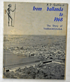
book, Yarrawonga Chronicle, From Ballanda to 1968; the story of Yarrawonga, October 1968
This book was published as part of the "Back to Yarrawonga" celebrations in October 1968 and the centenary of the First Survey of the Township of Yarrawonga.This is a useful reference tool on the history of Yarrawonga.A 90 pp paper back book titled, "From Ballanda to 1968; The Story of Yarrawonga". On the front cover on a glossy grey background is a photograph of Yarrawonga. The title is in blue print.yarrawonga-history -
 Bendigo Military Museum
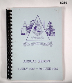
Administrative record - Army Survey Regiment Annual Report - 1 July 1986 - 30 Jun 1987
This report is a summary of activities carried out at the Army Survey Regiment during the F/Y 1986/87A4 report, light blue cardboard covered paper pages. Plastic ring binding. Army Svy Regt Logo/Emblem on cover. Contains text, photographs and diagrams.royal australian survey corps, rasvy, fortuna, army survey regiment, army svy regt, asr -
 Bendigo Military Museum
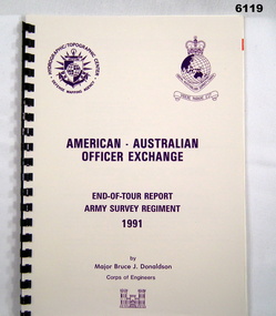
Administrative record - American - Australian Officer Exchange - End of Tour Report ASR 1991, Major B Donaldson US Corps of Engineers, Major Bruce J Donaldson, US Army Corps of Engineers, 01.06.1991
USA - Australia Army Officer Exchange End of Tour Report 1991, Army Survey Regiment , BendigoA4 Report, Gloss Card cover, DMA and RASvy Corps Badges on Cover, 9 Pagesroyal australian survey corps, rasvy, fortuna, army survey regiment, army svy regt, asr -
 Greensborough Historical Society
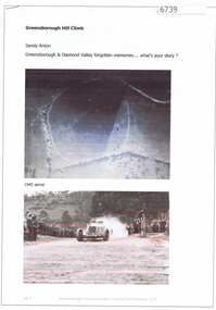
Article and Photograph, Greensborough Hill Climb, 2017_
Information and photos about the Greensborough Hill Climb included a copy of the 1945 aerial survey showing the track.This photograph and text was copied from a Facebook site. Members are people who lived in the Greensborough area and share their reminiscences of the area with others. The site is administered by a GHS member but is not officially affiliated with the Society. Any information is the opinion of the contributor. Article and photograph sourced from social media.greensborough hill climb 1945, bill halliburton -
Moorabbin Air Museum
Document (Item) - Mirage Field Service Surveys 1963-1967
Description: Mirage Field Service Surveys 1967-1976 Defect reports 580 -29 Level of Importance: . -
 City of Whittlesea
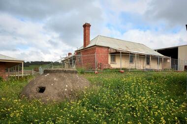
Photograph (item) - Photographs - Buildings, Hin Lim Photography, Blackbraes Farm, 21/6/2017
Blackbraes Farm is listed in the Whittlesea Heritage Overlay HO14, Photographic survey, 10 Cravens Road Merndablackbraes farm, mernda -
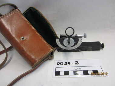 Wannon Water
Clinometre / Abney Level, E. R. Watts & Son, Clinometre
Abney Level / Clinometer is an accurate surveying tool used to measure degrees, percent of grade and topographic elevation. Used for surveying pipe lines.Instrument which consists of a fixed sighting tube, a movable spirit level connected to a pointing arm which turns and pivots. Adjustment knob/screw on top turns to rotate the compass indicator and bubble level. Arched scale graduated 0 to 90 degrees in both directions. Clinometer is housed in a brown leather case with a long leather strap for carrying around the neck.Watts London / No 70131 / Made in England