Showing 6779 items
matching historic.
-
 St Kilda Historical Society
Photograph - Photo map, 08/02/1966
One of a series of photo-maps produced for the Department of Crown Lands and Survey (1857-1983). For correlation with a current map, and access to other historical photo maps of Victoria, see the Historic Photo-Maps Index published by the Department of Environment, Land, Water and Planning at https://services.land.vic.gov.au/DELWPmaps/historical-photomaps/Black and white aerial photographVic 1916 Melbourne 1966 Project Run 13 E 8.2.66 Lens 122 151.75MM 9.800 111st kilda, balaclava, caulfield, caulfield north, st kilda east, elsternwick, elsterwick park, elwood park, elwood canal, elwood beach, ripponlea, 1966 -
 St Kilda Historical Society
Photograph - Photo map, 11/01/1968
One of a series of photo-maps produced for the Department of Crown Lands and Survey (1857-1983). For correlation with a current map, and access to other historical photo maps of Victoria, see the Historic Photo-Maps Index published by the Department of Environment, Land, Water and Planning at https://services.land.vic.gov.au/DELWPmaps/historical-photomaps/Black and white aerial photographVic 2132 State Aerial Survey Melbourne 1968 Proj Run 27E 11.1.68 5100 ASL 65caulfield north, caulfield park, armadale, malvern, 1968 -
 St Kilda Historical Society
Photograph - Photo map, 11/01/1968
One of a series of photo-maps produced for the Department of Crown Lands and Survey (1857-1983). For correlation with a current map, and access to other historical photo maps of Victoria, see the Historic Photo-Maps Index published by the Department of Environment, Land, Water and Planning at https://services.land.vic.gov.au/DELWPmaps/historical-photomaps/Black and white aerial photographVic 2132 State Aerial Survey Melbourne 1968 Proj Run 27E 11.1.68 5100 ASL 67st kilda east, st kilda cemetery, caulfield north, alma park, balaclava, armadale, 1968 -
 St Kilda Historical Society
Photograph - Photo map, 13/01/1968
One of a series of photo-maps produced for the Department of Crown Lands and Survey (1857-1983). For correlation with a current map, and access to other historical photo maps of Victoria, see the Historic Photo-Maps Index published by the Department of Environment, Land, Water and Planning at https://services.land.vic.gov.au/DELWPmaps/historical-photomaps/Black and white aerial photograph2138 State Aerial Survey Melbourne 1968 Proj. Run 26 13.1.68 5100 ASL 203st kilda west, albert park, fawkner park, south yarra, prahran, windsor, 1968 -
 St Kilda Historical Society
Photograph - Photo map, 11/01/1968
One of a series of photo-maps produced for the Department of Crown Lands and Survey (1857-1983). For correlation with a current map, and access to other historical photo maps of Victoria, see the Historic Photo-Maps Index published by the Department of Environment, Land, Water and Planning at https://services.land.vic.gov.au/DELWPmaps/historical-photomaps/Black and white aerial photographVic 2132 State Aerial Survey Melbourne 1968 Proj. Run 27E 11.1.68 5100 ASL 69st kilda, albert park, st kilda east, st kilda beach, alma park, windsor, prahran, 1968 -
 St Kilda Historical Society
Photograph - Photo map, 11/01/1968
One of a series of photo-maps produced for the Department of Crown Lands and Survey (1857-1983). For correlation with a current map, and access to other historical photo maps of Victoria, see the Historic Photo-Maps Index published by the Department of Environment, Land, Water and Planning at https://services.land.vic.gov.au/DELWPmaps/historical-photomaps/Black and white aerial photographVic 2132 State Aerial Survey Melbourne 1968 Proj. Run 28E 11.1.68 5100 ASL 81st kilda, balaclava, st kilda east, ripponlea, elwood, elsternwick, caulfield, st kilda botanical gardens, 1968 -
 St Kilda Historical Society
Photograph - Photo map, 11/01/1968
One of a series of photo-maps produced for the Department of Crown Lands and Survey (1857-1983). For correlation with a current map, and access to other historical photo maps of Victoria, see the Historic Photo-Maps Index published by the Department of Environment, Land, Water and Planning at https://services.land.vic.gov.au/DELWPmaps/historical-photomaps/Black and white aerial photographVic 2132 State Aerial Survey Melbourne 1968 Proj. Run 29E 11.1.68 5100 ASL 194elwood, elwood beach, elwood park, elsternwick park, ripponlea, elwood canal, balaclava, st kilda, 1968 -
 St Kilda Historical Society
Photograph - Photo map, 11/01/1968
One of a series of photo-maps produced for the Department of Crown Lands and Survey (1857-1983). For correlation with a current map, and access to other historical photo maps of Victoria, see the Historic Photo-Maps Index published by the Department of Environment, Land, Water and Planning at https://services.land.vic.gov.au/DELWPmaps/historical-photomaps/Black and white aerial photographVic 2132 State Aerial Survey Melbourne 1968 Proj. Run 27E 11.1.68 5100 ASLst kilda, st kilda west, st kilda pier, catani gardens, st kilda beach, albert park, 1968 -
 St Kilda Historical Society
Photograph - Photo map, 11/01/1968
One of a series of photo-maps produced for the Department of Crown Lands and Survey (1857-1983). For correlation with a current map, and access to other historical photo maps of Victoria, see the Historic Photo-Maps Index published by the Department of Environment, Land, Water and Planning at https://services.land.vic.gov.au/DELWPmaps/historical-photomaps/Black and white aerial photographVic 2132 State Aerial Survey Melbourne 1968 Proj. Run 29E 11.1.68 5100 ASL 196elwood, elwood park, elwood canal, elwood beach, st kilda marina, mc moran reserve, point ormond, 1968 -
 St Kilda Historical Society
Photograph - Photo map, Department of Crown Lands and Survey (1857-1983), 22/01/1970
One of a series of photo-maps produced for the Department of Crown Lands and Survey (1857-1983). For correlation with a current map, and access to other historical photo maps of Victoria, see the Historic Photo-Maps Index published by the Department of Environment, Land, Water and Planning at https://services.land.vic.gov.au/DELWPmaps/historical-photomaps/Black and white aerial photographVic 2358 Department of Crown Lands and Survey Victoria,.© Melbourne 1970 Project Run 41E 22.1.70 5,100 ASL 62caulfield, caulfield north, st kilda east, armadale, 1970 -
 St Kilda Historical Society
Photograph - Photo map, 14/12/1963
One of a series of photo-maps produced for the Department of Crown Lands and Survey (1857-1983). For correlation with a current map, and access to other historical photo maps of Victoria, see the Historic Photo-Maps Index published by the Department of Environment, Land, Water and Planning at https://services.land.vic.gov.au/DELWPmaps/historical-photomaps/Black and white aerial photographVic 1807 Melbourne 1963 Project Run 17 14.12.63 Lens 205 152.70 M/M 5.150 36st kilda, st kilda botanical gardens, balaclava, st kilda east, elwood canal, ripponlea, caulfield north, elwood, caulfield, 1963 -
 St Kilda Historical Society
Photograph - Photo map, Department of Crown Lands and Survey (1857-1983), 22/01/1970
One of a series of photo-maps produced for the Department of Crown Lands and Survey (1857-1983). For correlation with a current map, and access to other historical photo maps of Victoria, see the Historic Photo-Maps Index published by the Department of Environment, Land, Water and Planning at https://services.land.vic.gov.au/DELWPmaps/historical-photomaps/Black and white aerial photographVic 2358 Department of Crown Lands and Survey Victoria,.© Melbourne 1970 Project Run 42E 22.1.70 5,100 ASL 77st kilda, st kilda east, st kilda marina, elwood, elwood canal, elsternwick park, point ormond, balaclava, mc moran reserve, ripponlea, st kilda botanical gardens, peanut farm, 1970 -
 St Kilda Historical Society
Photograph - Photo map, Department of Crown Lands and Survey, 22/01/1970
One of a series of photo-maps produced for the Department of Crown Lands and Survey (1857-1983). For correlation with a current map, and access to other historical photo maps of Victoria, see the Historic Photo-Maps Index published by the Department of Environment, Land, Water and Planning at https://services.land.vic.gov.au/DELWPmaps/historical-photomaps/Black and white aerial photographVic 2358 Department of Crown Lands and Survey Victoria,.© Melbourne 1970 Project Run 43E 22.1.70 5,100 ASL 208elwood, elwood beach, point ormond, elwood park, elwood canal, mc moran reserve, 1970 -
 St Kilda Historical Society
Photograph - Photo map, Department of Crown Lands and Survey, 22/01/1970
One of a series of photo-maps produced for the Department of Crown Lands and Survey (1857-1983). For correlation with a current map, and access to other historical photo maps of Victoria, see the Historic Photo-Maps Index published by the Department of Environment, Land, Water and Planning at https://services.land.vic.gov.au/DELWPmaps/historical-photomaps/Black and white aerial photographCONTROLLED Vic 2358 Department of Crown Lands and Survey Victoria,.© Melbourne 1970 Project Run 41E 22.1.70 5,100 ASL 66st kilda, albert park, st kilda west, catani gardens, st kilda botanical gardens, st kilda pier, st kilda beach, 1970 -
 St Kilda Historical Society
Photograph - Photo map, Department of Crown Lands and Survey, 22/01/1970
One of a series of photo-maps produced for the Department of Crown Lands and Survey (1857-1983). For correlation with a current map, and access to other historical photo maps of Victoria, see the Historic Photo-Maps Index published by the Department of Environment, Land, Water and Planning at https://services.land.vic.gov.au/DELWPmaps/historical-photomaps/Black and white aerial photographVic 2358 Department of Crown Lands and Survey Victoria,.© Melbourne 1970 Project Run 42E 22.1.70 5,100 ASL 75st kilda, st kilda beach, st kilda marina, point ormond, st kilda pier, 1970 -
 St Kilda Historical Society
Photograph - Photo map, 14/12/1963
One of a series of photo-maps produced for the Department of Crown Lands and Survey (1857-1983). For correlation with a current map, and access to other historical photo maps of Victoria, see the Historic Photo-Maps Index published by the Department of Environment, Land, Water and Planning at https://services.land.vic.gov.au/DELWPmaps/historical-photomaps/Black and white aerial photographVic 1807 Melbourne 1963 Project Run 16 14.12.1963 Lens 205 152.70 M/M 5.150 177st kilda, st kilda pier, catani gardens, middle park, albert park, st kilda west, st kilda beach, 1963 -
 St Kilda Historical Society
Photograph - Photo map, Department of Crown Lands and Survey, 22/01/1970
One of a series of photo-maps produced for the Department of Crown Lands and Survey (1857-1983). For correlation with a current map, and access to other historical photo maps of Victoria, see the Historic Photo-Maps Index published by the Department of Environment, Land, Water and Planning at https://services.land.vic.gov.au/DELWPmaps/historical-photomaps/Black and white aerial photographVic 2358 Department of Crown Lands and Survey Victoria,.© Melbourne 1970 Project Run 41E 22.1.70 5,100 ASL 64st kilda, st kilda cemetery, balaclava, st kilda east, windsor, caulfield north, alma park, 1970 -
 St Kilda Historical Society
Photograph - Photo map, Department of Crown Lands and Survey, 08/01/1970
One of a series of photo-maps produced for the Department of Crown Lands and Survey (1857-1983). For correlation with a current map, and access to other historical photo maps of Victoria, see the Historic Photo-Maps Index published by the Department of Environment, Land, Water and Planning at https://services.land.vic.gov.au/DELWPmaps/historical-photomaps/Black and white arial photographVic 2345 Department of Crown Lands and Survey Victoria,.© Melbourne 1970 Project Run 40 8.1.70 5,100 ASL 77albert park, fawkner park, south yarra, middle park, prahran, windsor, st kilda, st kilda west, 1970 -
 St Kilda Historical Society
Photograph - Photo map, 22/01/1970
One of a series of photo-maps produced for the Department of Crown Lands and Survey (1857-1983). For correlation with a current map, and access to other historical photo maps of Victoria, see the Historic Photo-Maps Index published by the Department of Environment, Land, Water and Planning at https://services.land.vic.gov.au/DELWPmaps/historical-photomaps/Black and white aerial photographVic 2358 Department of Crown Lands and Survey Victoria,.© Melbourne 1970 Project Run 43E 22.1.70 5,100 ASL 206elwood, elsternwick, elsternwick park, 1970 -
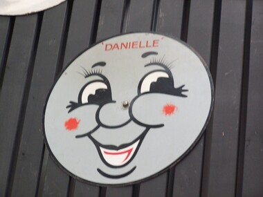 Puffing Billy Railway
Danielle Locomotive Head Board
Historic - Puffing Billy Railway Locomotive Head Board used in the Celebration of Special Children's train days wooden Train Headboard - Danielle - face used on Children's special Train ride days The name Danielle was allotted to Decauville locomotive 986/1890 (also known as Carbon) on these special days. Historic - Puffing Billy Railway Locomotive Head Board used in the Celebration of Special Children's train days Locomotive Head Board - Danielle painted wooden Train Headboard - Danielle - face Daniellepuffing billy, head board, danielle -
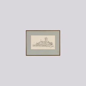 Wangaratta Art Gallery
Work on paper, Maurice Cantlon, Bontharambo, 1965
Cantlon is widely known for his illustrative paintings of Victorian historic homes, and he wrote and illustrated Homesteads of Victoria 1836-1900 published by Georgian House in 1967. Bontharambo is a homestead located in Wangaratta and was built in 1857-9. This homestead plays a prominent role in the history of Wangaratta and the pastoral history of Victoria. Rural City of Wangaratta Collection. Purchased with funds from the Wangaratta Art Council.An black ink sketch of the Bontharambo homestead on white paper.Obverse: Cantlon 65/ (bottom right)wangaratta art gallery, maurice cantlon, ink drawing, bontharambo, homestead -
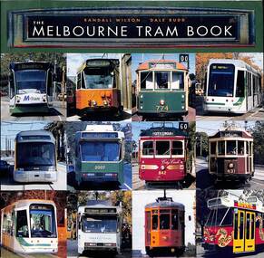 Ballarat Tramway Museum
Book, "The Melbourne Tram Book" - 1st edition, 2003
Book - titled "The Melbourne Tram Book" - 1st Edition, written by Randal Wilson and Dale Budd - 2003. Covers Melbourne tram history including cable trams, early electric trams, trams in art, historic fleet, colour schemes, tram types, and preserved tramways. Includes notes on the authors. Yields information about Melbourne trams history. Has a close association with two well known authors.Book - 84 pages including card covers, full colour printing on gloss paper, perfect bound with foldout covers containing four postcards that could be removed.melbourne, tramways, trams, history, randal wilson, dale budd -
 Clunes Museum
Film - DVD, Postcards - Episode 22, 2008, 2008
Visual programme featuring Widow Twankey's. a local cafe, and the Clunes Museum prior to the redevelopment of the site at 36 Fraser Street, in 2012. Interviews of Tim Hayes, owner of Widow Twankey's and Pat Cook the Curator of Clunes Museum. Images of significant sites and historic buildings as well as streetscapes and landscapes of Clunes.DVD IN WHITE PAPER SLEEVE CHANNFEL 9 POSTCARDS, EPISODE 22 "GENERAL SHOW"widow twankey's, pat cook, tim hayes, clunes museum -
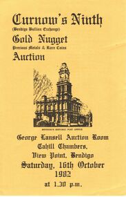 Bendigo Historical Society Inc.
Document - IAN DYETT COLLECTION: AUCTION CATALOGUE - CURNOW'S NINTH GOLD NUGGET PRECIOUS METALS
Yellow catalogue with black printing for Curnow's Ninth Gold Nugget Precious Metals & Rare Coins Auction held in the George Lansell Auction Room, Cahill Chambers, View Point, Bendigo on 16th October 1982. On the front is a black sketch of Bendigo Historic Post Office. The inside contains a list of Nuggets with Lot No., Approx. Weight in Grams, Area of Find, Code, Why Buy Gold? And Note to Buyers. The left front has the Conditions of Sale and the centre front has Curnows name and a Reproduction of Curnows original Letterhead circa 1900. Sale includes nuggets from Victoria and Interstate.business, auctioneers, j h curnow & son pty ltd, ian dyett collection - auction catalogue - curnow's ninth gold nugget precious metals & rare coins auction, bolton bros pty ltd, j h curnow, j h curnow & son pty ltd, ian dyett, fred dyett -
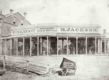 Bendigo Historical Society Inc.
Photograph - JACKSON'S GOLD OFFICE, VIEW POINT, BENDIGO - 1861?, 1860's ?
black and white ( copy ) H. Jackson's Gold Office, View Point, Bendigo. Men standing otuside office under verandah. Batchelder, Photographer, Pall Mall. Also Finlay & Co. See also Mosaic items 2400.160 and 2400.101. All details in Mike Butcher and Yolande Collis's book, An American on the Goldfields : the Bendigo Photographs of Benjamin Pierce Batchelder.' Also details of Henry Jackson's store in Bendigo Historic Buildings by Mike Butcher and Gill Flanders. National Trust of Australia (Vic). Central Victorian Branch. 1987. See Research Field for further information.Batchelder, Photographer, Pall Mallorganization, business, h. jackson's gold office, jackson, henry. finlay & co. view point, bendigo. jackson's corner. jackson's gold office. -
 Bendigo Historical Society Inc.
Document - NATIONAL TRUST COLLECTION: THE BEEHIVE, 1987-1988
The Beehive and Old Gold Exchange Hand written letter and one photocopy to Mr Ray Tonkin, Director, Historic Building Council. Photocopy of history assignment by Diane Hartley (98) Letter to Ben Prop of the Property trust. Letter to Ray Tonkin re suggested changes to the Beehive and Allans Walk, Letter to Ben Prop Property Trust informing of classification of the Beehive. Letter to Mr David Martin from Alan Powney re restoration. National Trust Data Form. Letter to Mr D.D. Martin from Ray Tonkin re application to the register of historical buildings.bendigo, buildings -
Port Melbourne Historical & Preservation Society
Book - Greek publications, Donations to City of Port Melbourne from Limni, Greece, 1980s
These publications reflect the period when Greek people were the largest ethnic group in Port Melbourne. During his tenure as Mayor, Cr WHITE fostered a strong ethic of multi-culturalism in Port Melbourne and set up a city relationship with Limni which donated these books. Perce made trip(s?) to Limni.Four Greek publications donated to the City of Port Melbourne by our sister city in Greece, Limni. .01 'Panagia y Limnia' - illustrated history and guide to Limni church(es), softcover 70pp. 1985. .02 'To Elumnion - (limni) 1969 green softcover 260pp. Appears to be a scholarly work by Nicholas K BELLARA about Limni, dedicated on fly leaf to Mayor Perc WHITE. .03 'Omorphis Tis Aimnis' - softcover B&W picture book of the town. 48pp includes historic photos. .04 'Limniotiki Phoni' - Limni newspaper 8pp. May/June 1987..02 - in ink on fly leaf. Athens July 4 1987 To the Mayor of Port Melbourne Mr Perc White - The Athinian Club of Limni sends its best wishes for teh happy event +name + Address. .03 - on the title page. To the Honourable Members of the Port Melbourne Town Hall with much esteem and appreciation for the work they have been doing for the promotion of the LIMNI - PORT MELBOURNE friendship etc. etc. 5.6.1989.migrants, perce mcguire white, perce white -
 Ballarat Tramway Museum
Ephemera - Tourist Guides, "Ballarat Visitors Guide July - Dec. 1998."', Jul. 1098
Ballarat Courier Publication Issue 4 as 6 monthly Visitor/Tourist Guide. Including details of events in calendar format as well as some stores relating to major events, eg. the Begonia Festival Issue 4 - July to Dec. 1998, p20 under heading of Transport and tours, suggestion to historic tram ride, followed by a 1/6 page coloured photo of tram 26. Also on same page "City Circle Heritage Tour Bus" item. See 776.1 and .2 for previous issues. See Reg Item 5465 for City Circle Bus brochure.tourism, btm, tourist guides -
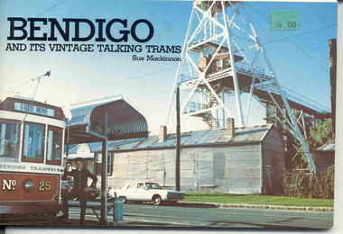 Ballarat Tramway Museum
Book, "Bendigo and its Vintage Talking Trams", Dec. 1981
Yields information about Bendigo, its tramways, tramcars and preservation by the Bendigo Trust.Book - 100 pages, plus printed colour covers on gloss paper, centre stapled, titled "Bendigo and its Vintage Talking Trams", authored by Sue Mackinnon, printed by the Bendigo Trust December 1981. Has many historic photos of Bendigo, trams in the streets of Bendigo and its then fleet of trams. Gives a history of the trams in Bendigo, including battery tram, steam, ESCo, SEC, the Trust, Central Deborah Gold Mine and its trammies. Has a centre page colour photos of the mine and one of the Birney. In the top right hand corner is a green price label "4.00".trams, tramways, bendigo, battery trams, bendigo trust -
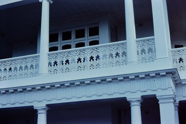 Kew Historical Society Inc
Slide - 'Studley House', Nolan Avenue, 1976
Colour transparency (slide) created in June 1976 during a tour by the Junior National Trust, which was led by members of Kew Historical Society. The collection of 21 slides reveals that the tour covered all parts of Kew, but focused understandably on heritage buildings and sites.Image of an historic place in Kew that can be dated to an exact time and place. The images, albeit amateurish in composition, frequently reveal aspects of important buildings and sites that have changed over time.35mm colour transparency of Studley House in Nolan Avenue, Kew, now part of Xavier Primary School. The Victorian Historic Buildings Register describes the building as: ""Studley House", 15 Nolan Avenue Kew is an early house, extensively added to, which is of architectural importance in its present form and has important historical associations with John Hodgson, an early settler in the district and with subsequent owners. The first part of the house is an early and particularly fine example of the Italianate style in Victoria. The later additions dwarf the original house but are of interest in their own right. Plaster and woodwork internally and some stained glass are notable."historic houses -- kew (vic.), nolan avenue -- kew (vic), xavier college -- kew (vic.), studley house -- nolan avenue -- kew (vic.)