Showing 1517 items matching "land use"
-
 Bendigo Historical Society Inc.
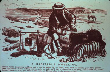
Slide - DIGGERS & MINING. LIFE OF THE SELECTORS, c1874
Diggers & Mining. Life Of the Selectors. Picture titled 'A Habitable Dwelling. ROUGH PARTY (appearing suddenly out of the end of a hollow log). ''Hullo, mate, what the blanks your little game?'' FREE SELECTOR. - ''Oh! Nothing much; going to take up a bit of land-run a few sheep, that's all friends.'' ROUGH PARTY. - ''Well, you needn't have come so blanked to the HOME STATION.'' Picture depicts man climbing out of a log and a man sitting on the log, and the billy over the fire with horse in background. Markings: Life Of the Selectors 1860 - 1890 Set 432 No. 20. A Habitable Dwelling- ''Melbourne Punch,'' October 22, 1874. Used as a teaching aid.Visual Education Centereducation, tertiary, goldfields -
 Flagstaff Hill Maritime Museum and Village
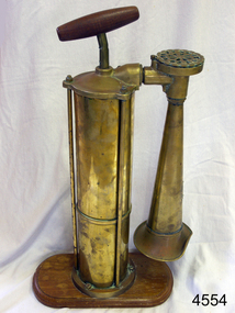
Equipment - Foghorn, 20th century
A marine foghorn gives an audible navigational signal to warn vessels of dangers, hazards and the presence of other vessels in fog conditions. The foghorn signal is a series of long and short sounds with short or long pauses between them. These common signals conform to a code called the International Regulations for Preventing Collisions at Sea and provide such information as whether the vessel is under sail or motor, large or small, aground or at anchor. The designs of foghorns vary but they all use a column of air to make a loud sound. Some use vibrating plates or metal reeds, others force air through holes in a revolving cylinder or disc, sounding like a siren, and some use a clockwork mechanism to open the valves that let the air into the horn. They are usually built to meet particular specifications e.g. U.S.C.G. (US Coast Guard). This Tyfon plunger foghorn has a horizontal handle attached to a vertical rod that moves up and down inside a cylinder. When the handle is plunged down, in a similar way to a bicycle pump, the air is forced out of the bottom of the cylinder into a pipe with a bell-shaped horn on the end, making a loud, low sound. The wider base of the cylinder helps to keep it stable. The original type Tyfon foghorns were manufactured in about 1910 by Kochums Mechanical Workshop (Kockums Mechanical Werkstad, Ltd.), Malmo, Sweden. The company was established in 1840, became a Limited company in 1866, and established a shipyard at the Port of Malmo, Sweden, in 1870. The civilian ship production in Malmo ceased in 1987. As well as building ships the company built large industrial and agricultural machinery and maritime goods.this replica foghorn represents the design of a Swedish, Tyfon model 1910. It is an example of the type of safety equipment used on marine vessels to signal other vessels and signal to land. Replica foghorn; portable marine, plunger operation. It has a brass cylinder and adjustable brass horn. The plunger handle and base are wooden. Inscriptions are on the plaque on the horn and moulded into the air intake. Facsimile of a Kockums of Malmo, Sweden, Tyfon model 1910 Fog Horn.Impressed into the attached plaque "KOCKUMS MLK. VERKSTAD / MALMO SWEDEN" and "TRADE TYFON MARK" Also added to the plaque individually "288938" Molded around the circumference of the air intake "TYFON PATENT"flagstaff hill, warrnambool, shipwrecked coast, flagstaff hill maritime museum, maritime museum, shipwreck coast, flagstaff hill maritime village, great ocean road, foghorn, fog horn, tyfon foghorn, kockums mlk verkstad, malmo sweden, replica, warning signal, safety equipment, ship's equipment -
 Bendigo Military Museum
Equipment - MESSAGE STREAMER, c. 1918 ?
Message Streamer used to communicate with the ground before radios. Message reads: “Have burst tyre, cannot land Give V sign if search finished. If not, stand on your hands. Richy Bair S/L” Item belonged to Maxwell Lennox Matheson No 418447 RAAF. Refer Cat No 1959 for his service history..1) Banner 6 fabric panels, 2 red, 2 beige, 2 brown centre connecting panel - hessian like fabric. .2) Folded note paper. Message written in pen on bottom left hand corner..1) “HGR10 1918” (stamped in centre panel)communications, signals, message -
 Bendigo Historical Society Inc.
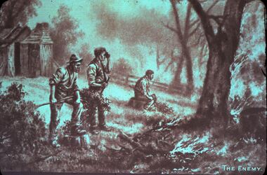
Slide - DIGGERS & MINING. LIFE OF THE SELECTORS, c1860 - 1890
BHS CollectionDiggers & mining. Life Of The Selectors. 3 men clearing the land by hand (one appears to be a native). Hut in background. Markings; Life Of The Selectors 1860 - 1890. Set 432 No.12. The Enemy - a photograph of a painting by J. A. Turner. Picture titled: The Enemy. Used as a teaching aid.Visual Education Centreeducation, tertiary, goldfields -
 Kew Historical Society Inc
Work on paper - Sepia Wash & Ink, G B Richardson, Creek and Old Watering Stage, on the Yarra, East Collingwood, 1854, 1854
Blind Creek was located between the Abbotsford Convent and what is now the Collins Bridge in Studley Park. In an 1858 map of East Collingwood by Clement Hodgkinson, in the State Library of Victoria, one can see how the creek was originally a significant landmark in Collingwood; remaining vacant land until a barrel drain enclosed it. The area was later filled in, surveyed and developed. The position where Blind Creek entered the Yarra was in the immediate vicinity of Hodgson’s Punt, which had linked Kew to the other side of the Yarra from 1839. The Punt was purchased by the Colonial Government in 1852 and was in use until the opening of the Studley Park Road (Johnston Street) Bridge in 1858 made its continued use redundantThe point of view selected by the artist for the watercolour is from the banks of Blind Creek in East Collingwood, looking across the Yarra to the Kew side of the river.Inscribed verso 'Creek and Old Watering stage, on the Yarra East Collingwood 1854 / Trees, stage, &c have long since disappeared / [Artist Signature] / FT 110 / Creek itself now being filled in 1903.gb richardson, blind creek - abbotsford, yarra river - abbotsford (vic) - kew (vic), colonial artists, australian art - 19th century, george bouchier richardson -
 Melbourne Tram Museum
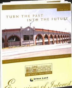
Document - Folder with papers, Urban Land corporation, "Hawthorn Tram Depot - Expressions of Interest Documentation", late 1998
White two spring clip folder with papers, titled "Hawthorn Tram Depot - Expressions of Interest Documentation", sub-titled "Turn the Past into the Future" Has a photo of Hawthorn Tram depot and an image on the front cover. Closing date 17/2/1999, prepared by the Urban Land Corporation with the assistance of VicTrack. Approx 110 pages with supplementary papers in the end covers. Contains a table of contents, checklist, EOI Process, Development Brief, Site conditions. Gives details of the heritage registration, site plans, building plans, property title and detailed room condition and use of the ground floor. Supplementary papers include the marketing brochure, letters and a detail feature and level survey by Bosco Johnson surveyors, 30-9-1998.trams, tramways, htt, hawthorn tram depot, sale of land, property -
 Melbourne Tram Museum
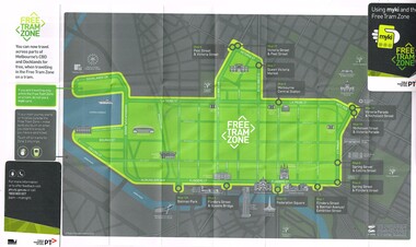
Map, Public Transport Victoria (PTV), "Using myki and the Free Tram Zone", 2015
Folded paper map with glued card in two of the corners to give the document some strength or usability (24 folds), titled "Using myki and the Free Tram Zone" details the extent of the free tram zone or showing the tram lines that the free travel is allowed, locations, land marks, contact numbers and has the PTV logo in the top right hand corner and the Myki logos. The reverse details how the Myki system works, the various types of tickets, how to buy, visitor packs and using and managing Myki tickets.trams, tramways, yarra trams, ptv, maps, free tram, melbourne, myki -
 Melbourne Tram Museum
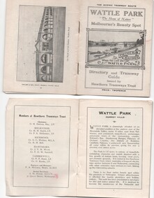
Ephemera - Timetable, Hawthorn Tramways Trust (HTT), "Directory and Tramway Guide issued by the Hawthorn Tramways Trust", 1918
Booklet - 38 pages, printed on off white page, centre stapled, titled "Directory and Tramway Guide issued by the Hawthorn Tramways Trust", specifically advertising Wattle Park and showing Princes Bridge and the Yarra on the front cover and a photo of Hawthorn depot on the rear cover. Gives details of Wattle Park, its opening, many photos, members of the Trust, Engineer and Manager and Acting Secretary, Stopping points for the round and fares to Wattle Park, section fares, maps of the tram routes and connections with other tramways and railway stations. Has timetables for Burnley and other major points, special and emergency services, the coloured lights used on the trams, and a map for land sales at Riversdale Heights estate. Advertisements for Mutual stores, Melbourne Electric Supply Co., Moule, Hamilton and Kindle for the sale of land at Riversdale Heights and a map showing the estate location. Both copies have alterations or corrections to the route signage letters - marked in red - from the Minutes of the HTT Board meetings, the Trust were not happy with the finished product and was reluctant to pay for them - see Minutes of Meeting No. 99 of 5-7-1918. Two copies held - one with red marks on the front cover.trams, tramways, htt, wattle park, princes bridge, hawthorn depot, timetables, mesco, real estate -
 Melbourne Tram Museum
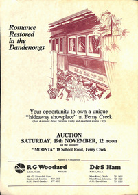
Document - Personal Papers, The Age, Keith Kings, Progress Press, Higgins Teale & Co, Herald Sun, house built using former PMTT tramcars, 1976 to 1983
Collection of Personal Papers regarding a house built using former PMTT tramcars. Comprises: 1 - Auction notice - folded A3 light card, "Moonta 18 School Road Ferny Creek" - giving details of the property, agents, floor plan and auction date of 19/11/1983. Agents R. Woodard and D&S Ham (2 copies held) 2 - Newspaper clipping from the Progress Press with a sketch and article - "Home built from trams" 3 -"Fares please for tram treat" - Herald Sun, 24/9/1983. 4 -Auction notice - 21/11/1983 - property passed in. 5 - hand written note, with plan of the trams and location map - not dated 6 - set of six hand written notes recording conversations with various people regarding a house in Ferny Creek with trams, including the Public Trustee 1976 and 1977. 7 - Auction notice for "Charrawalla" - School Road, Ferny Creek dated 7/5/1977 from The Age. Not all items numbered, See also Reg Item 1356, 1833 and 1518 for related items.trams, tramways, mmtb, pmtt, ferny creek, tramcars, melbourne, houses, sale of land -
 Melbourne Tram Museum
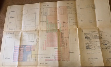
Drawing, Melbourne & Metropolitan Tramways Board (MMTB), "Footscray Depot - Layout Plan - Scheme II", 23/03/1960 12:00:00 AM
Drawings - coloured - titled "Footscray Depot - Layout Plan - Scheme II", signed by D. H. Eakins on 23-3-1960 showing a proposed layout of the depot following the closure of the Footscray system and the use of the entire block of land for buses. Has drawings of the Traffic Office and Amenities.trams, tramways, footscray, buses, depots -
 Melbourne Tram Museum
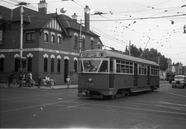
Negative, Wal Jack, 9/02/1951 12:00:00 AM
Black and white negative, by Wal Jack, of PCC 980, northbound bound in Glenferrie Road at High Street with the destination of Kew Cotham Road. The Bank was replaced by a more modern looking building during the 1970's. In the background is the ES&A bank on the corner. Jane Nigro advised 9/9/2020: "1907 Photo of the E. S. & A. Bank on the corner of High Street and Glenferrie Road, Malvern. In 1885 land on corner of Glenferrie Road & High St. (40' x 150') was purchased by E.S. & A. Bank. A condition of sale was that the bank erect on the land a 'substantial brick building to be used as a branch bank', within 24 months. The E.S. & A. Bank, single-storey four roomed brick, was built in 1888. The first manager was Frederick Leonard. In 1907 a second storey, including residential quarters for the manager, was added to bank at a cost of £1400.The Bank was demolished in 1958-9and replaced with present building."trams, tramways, pcc class, glenferrie road, route 69, kew- cotham rd, tram 980 -
 Federation University Art Collection
Work on paper - Printmaking - Multiplate Etching, Dean Bowen, 'The Car Park' by Dean Bowen, 1994
Dean BOWEN (1957 -) Born Maryborough, Victoria Dean Bowen's work combines humour and gentle irony with technical proficiency to explore the world around him. 'The car park epitomises qualities found in the best of his post 1990 work. Born out of the daily grind of stop-start commuting by car along Melbourne's Punt Road to and from his former workplace, the feeling of this large work (just over two metres long) is of duality. On the one hand there is the crowded chaos of a relentless number of cars choking the roads; on the other, order is imposed in his aerial view of cars 'parked' around intersecting roads as well as the actual charting of roads and interstitial spaces. Zooming in as though from above, cars are alternately cross-sectioned and flattened in outline. Despite his denial that there is nothing reminiscent of Aboriginal art in this work, to the onlooker there are quite a number of similarities. Not that he presumes anything of the Aboriginal experience or imagery (indeed, that it is unconscious is probably the only reason it works), such qualities are nevertheless present. The aerial perspective, for example, is so like the Aboriginal system of painting song lines and dreaming tracks from above. And as seen in the famous 'X ray' paintings of Arnhem Land, his cars and buildings are cross-sectioned to reveal the objects (usually humans) within. The impression of Aboriginally is further given by his use of earthy browns and by the outlining of shapes (cars, roads, trees).' (Susan McCulloch) This work was selected by the Art Acquisitions Committee (1995) to be placed in the 1870 Founders Hall at Mt Helen Campus. The Federation University Art Collection features over 2000 works and was listed as a 'Ballarat Treasure' in 2007.A multiprint etching depicting a carpark that won the 1994 Fremantle Print Award;Edition 12/20art, artwork, dean bowen, bowen, etching, multi-plate etching, printmaking, printmaking etching, carpark -
 Federation University Art Collection
Artwork - Painting, [Welcome] by Josh Muir, 2014
Josh MUIR (1991- 2022) Yorta Yorta/Gunditjmara/Barkinjl Muir's art draws on hip-hop and street art culture and often depicts the history of indigenous people and European settlers. He spent a lot of time in his teens researching and enjoying public art, especially graffiti. Inspired by the commitment of graffers he was inspired by the concepts they illustrate. He started expressing his own ideas with pen and pad and once the basic concept down and it was tangible and could be converted that to canvas or walls. Muir experimented with spray and stencil work a lot in his teens and later branched out into acrylic paints, paint pens, and digital forms of Art. In 2016 Josh Muir's work 'Still Here', projected onto the front wall of the National Gallery of Victoria was critically acclaimed. At that time he stated: "‘I am a proud Yorta Yorta/ Gunditjmara man, born and living in Ballarat, Victoria. I hold my culture strong to my heart – it gives me a voice and a great sense of my identity. When I look around, I see empires built on aboriginal land. I cannot physically change or shift this, though I can make the most of my culture in a contemporary setting and use my art projects to address current issues of reconciliation." In 2016 Josh Muir was awarded the second recipient of HMS Trust’s Hutchinson Indigenous Fellowship at University of Melbourne, based at the Victorian College of the Arts (VCA). The Fellowship was created to enable Indigenous artists to undertake significant projects of their choice. Computer generated image on canvas.josh muir, aboriginal, artwork, artist, hutchinson indigenous fellowship -
 Bendigo Historical Society Inc.
Slide - DIGGERS & MINING. LIFE OF THE SELECTORS, c1876
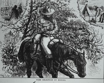
BHS CollectionDiggers & mining. Life Of The Selectors. Minor carring baby while riding horse, people at table on the left at top rear. Minor boiling the billy, and a small child in the tent at the rear right of picture. Markings; Life Of The Selectors 1860-1890. Set 432 No.2 Free. Selection by Minors - ‘’The Australian Sketcher,' Jan 22, 1876. Caption at bottom of sketch; Free By The Minors. Rear left caption; Before the Land Court. Caption rear right; A residence. Used as a teaching aid.Visual Education Centreeducation, tertiary, goldfields -
 Melbourne Tram Museum
Magazine, Department of Infrastructure (DOI), "New Home for Heritage Trams", Dec. 1998
Eight page magazine, folded A3 printed on gloss paper, blue and black ink, "Infrazine" - Department of Infrastructure Victoria, Issue 11, December 1998 with the main article on the redevelopment of Hawthorn Tram depot - titled "New Home for Heritage Trams". Gives details of the history of the depot, involvement of the Department of Infrastructure, Public Transport Corporation, and the Urban Land Corporation, TMSV and the future use of the heritage trams. Article signed by Brandon Mack. Other items cover legal services, the Marine Board, regional offices.trams, tramways, hawthorn depot, ptc, doi, reconstruction -
 Federation University Historical Collection
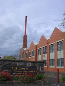
Photograph - Brewery Building, Ballarat School of Mines Brewery Building, 06/10/2011
In 1872 William Tulloch and Alexander McLaren constructed a new brick 'Royal Standard Brewery' to the design of architect Henry R. Caselli. They had been operating a much smaller 'Royal Standard' Brewery, possibly since 1859. The Ballarat Brewing Company was established in 1895 and took over operations of the 'Royal Standard'. This new company resulted in the merger of the 'Royal Standard Brewery', James Coglans 'Phoenix Brewery' (Warrenheip) and Henry Leggo's 'Barley Sheaf Brewery' (Creswick Rd). J. Coglan and W. Tulloch were principals of the new company. By 1912 the Ballarat Brewery buildings fronting Armstrong Street were upgraded and new plant installed. Ballarat Brewing Company was well established as a thriving business. In 1926 'Ballarat Bertie' (the cellar-man) advertising image was introduced. It was used successfully until 1994 on 'Ballarat Bitter' labels. During the1940s and 50s the Ballarat Brewing Company was significantly upgraded and extended equipment and buildings. In 1959 Carlton and United Breweries purchased the Ballarat Brewery, its brewing rights and the land (but not the 114 BBC hotels or the Dana Street offices). The Lydiard Street frontage become the 'front' of the CUB Brewery. CUB ceased brewing at the Ballarat Brewery site in 1989 and closed the plant. Four years later the 'brewery site' was purchased by the Ballarat School of Mines to enlarge its campus area as TAFE was a rapidly expanding areas of education. In 1994 plans were developed for the 'Brewery Complex' with careful regard for needed educational facilities and due concern regarding historical aspects of the site and its buildings. There was close consultation and cooperation with the Ballarat City Council during the planning process. In 1995 most of the Brewery buildings were demolished by some special structures and features are preserved. The old brewery chimney was retained as a permanent reminder of the original industrial site, as were two boilers. The SMB Brewery Complex was completed in 1996 and reflects aspects of the former brewery's appearance. It was opened by Prime Minister John Howard on 28 February 1997. Further details at http://guerin.ballarat.edu.au/curator/buildings/site_listing_brewery-complex.shtml Twenty five colour photographs of the Brewery Building at the University of Ballarat SMB (Ballarat School of Mines) campus. The Brewery Building is built on the site of the former Ballarat Brewery and incorporates the chimney and 'Cowley' boilers from that site. ballarat school of mines, henry richards caselli, henry caselli, ballarat brewing, brewery, beer, cowleys foundry, carlton and united breweries, ballarat brewery site -
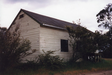 Lakes Entrance Historical Society
Photograph - Nungurner School, 2000
Erected by voluntary labour in 1924 as Community Hall and School, on land donated by H Jemmeson. The Education Department paid rent. Opened September 1924 by Albert Lind, used as school until new school opened in February 1963. Destroyed by fire September 2011 and site cleared.Colour photograph showing side of old Nungurner Hall / School, timber clad, corrugated iron gable roof, small window in side wall. Nungurner Victoriaschools, halls -
 Phillip Island and District Historical Society Inc.
Memorabilia, Phillip Island Memorabilia
Items used in Research for Book - "Penguin Land" by Gregor BuchananHistorical1162-01 Article from the Wonthaggi Express - Penguin Parade Admission 1162-02 Brochure called "The Short Way to Cowes" detailing taking the train from Flinders Street Railway Station, Melbourne to Stony Point then by Ferry to Cowes 1162-03 Pg 1 & 2 - Souvenir Programme "Music for the People" to be held weather permitting on the Cowes Foreshore at 2pm February 20th, 1955 1162-04 - Card - Drawing of a Fur Seal - one of the 5000-odd Seals on Seal Rocks, as seen from The Nobbies Road House, Phillip Island 1162-05 Pg 1 & 2 - Cowes - Dandenong Road Service showing Daily Road Route and connection from Dandenong to Flinders St. Melbourne. Time Table to and from Cowes to Dandenong"penguin land" book, gregor buchanan, seals, ferry, stony point to cowes, cowes to dandenong, penguin parade, variety concert ticket, tourism -
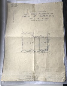 Luther College
Map, Plan of Subdivision, 1957
This map shows the original subdivision of land on the corner of Plymouth Road and Yarra Road. The land previously belonged to Phillip Brucker, who used the property as a small farm. Brucker offered his land at a reduced price to the Lutheran Church, who were seeking a location for their new secondary school endeavour.This is the oldest map of Luther Collegemap, building plans -
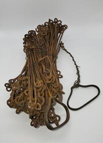 Glenelg Shire Council Cultural Collection
Equipment - Surveyors chain, unknown
... Before metric measurement was introduced land was measured ...Before metric measurement was introduced land was measured by a tool of chains and links called a surveyor's chain. The first surveyor's chain was designed by the English clergyman and mathematician Edmund Gunter (1581-1626) and introduced in 1620. It comprised of a metal chain made up of 100 links measuring a precise overall length of 66 ft or 22 yards, with each link measuring 7.92 inches (201.168 mm). The Gunter's chain was originally intended to be used in the accurate laying out and measurement of plots of land, for legal and commercial purposes, but was subsequently widely used by surveyors throughout the British Empire and Europe, with an Imperial mile being 80 times the Gunter's chain length. A tool used to survey the land before the introduction of the metric system.Surveyor chain Gunter type, 100 links measuring 66 feet in length. Hand grips at each end of chain. Wire links are approximately eight inches long. Incised tags or markers are attached to each tenth link of chain to assist with the more accurate recording of intermediate distances.surveying tool -
 Glenelg Shire Council Cultural Collection
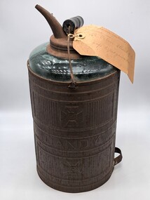
Functional object - Kerosene Container, Dandy, 1900s
This glass kerosene lamp was used at St Peter's Church of England at Cape Bridgewater. From Victorian Heritage Database - St. Peter's Anglican Church (former) is a small sandstone church, located at the end of Bridgewater Fire Station Road. The church was constructed between 1883-1884, as a result of lobbying by the congregation and the Reverend Allnutt to establish an Anglican Church in the area. The area was predominately Presbyterian and Methodist, so such a fine church was somewhat unusual. There was obviously much community support for the establishment of the church; the land was donated by Kennedy, a nearby landholder, and the stone was quarried for free at Mount Pleasant, owned by the Kittson family. The church was designed gratis by the ecclesiastical architect, Mr. Casselli of Ballarat, who designed many significant buildings throughout Victoria in the nineteenth century. The building contractors were a local firm, Messrs. Benson and Hardie. The church retains a high degree of integrity externally, and is in good condition. This item is significant because it demonstrates early methods of storing fuel. It is also connected to St Peter's Anglican Church in cape Bridgewater which is now a visitor accommodationA glass container with a metal sleeve. The top of the glass container has a metal opening and screw top as well as a spout for pouring. There is a metal carry handle with a wooden cylinder in the middle for carrying. This is only fixed to the container on one side as the metal eyelet on one side has broken off. The metal sleeve on the glass container has embossed pattering above and below the word - Dandy. There is an old carboard label attached to the top with string.Metal sleeve - DANDY Label -This kerosene container was used in / St Peter's Church of E / Cape Bridgewaterreligion, church, place of worship, cape bridgewater, st peters church, anglican, glenelg shire, glenelg, portland, fuel, kero, kerosene, light -
![Book, Dr Judith Buckrich, Yarra Birrarung: artists, writers and the river, [2024]](/media/collectors/4f729f7b97f83e03086018a5/items/67ba8835406af522eeba63c0/item-media/67be949eac2704e0db957062/item-fit-380x285.jpg) Eltham District Historical Society Inc
Eltham District Historical Society IncBook, Dr Judith Buckrich, Yarra Birrarung: artists, writers and the river, [2024]
... flourished on the river, including recreation, industry and land use ...Yarra Birrarung: Artists, Writers and the River is an illustrated history of life on the Yarra. Through the lens of artists and writers, the book explores how life has flourished on the river, including recreation, industry and land use, as well as infrastructure, natural history and social history. This is the first comprehensive illustrated story of the Yarra River over the past 200 years, examined through the lives of its creatives.256 p.non-fictionYarra Birrarung: Artists, Writers and the River is an illustrated history of life on the Yarra. Through the lens of artists and writers, the book explores how life has flourished on the river, including recreation, industry and land use, as well as infrastructure, natural history and social history. This is the first comprehensive illustrated story of the Yarra River over the past 200 years, examined through the lives of its creatives.yarra river, melbourne -
 Department of Energy, Environment and Climate Action
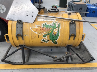
Aerial Drip Torch (ADT) or "Dragon"
The Aerial Drip Torch (ADT) was an idea conceived in Canada in the 1970s by John Muraro It was developed in 1982 by the New Zealand Forest Service to become the Ashley Aphid Helitorch. Forestry Tasmania acquired one of the machines and modified it in February 1987. Also known as a dragon helitorch it consisted of a large 135-litre tank containing jellied petrol, a displacement pump, propane ignition system, burner nozzle and fire extinguisher system. It was first trialled in Victoria at Swifts Creek in 1991 and the Aerial Drip Torch (ADT) has now become standard practice.Two Aerial Drip Torches (ADTs) were built in the 1990s by the Fire Equipment Development Centre at North Altona, They were developed in conjunction with the Department of Conservation and Land Management in Western Australia. The first was trialled during the 1991/92 autumn burning season. The machine proved to be successful and a second machine was introduced in 1998 to assist with burning operations across the State. The ADTs were commonly used for regeneration burning (controlled burning of logging slash). The first ADT introduced in 1992 had a dry weight of 160kg and a capacity of 130 litres, providing about an hour of operation. Following initial use, systematic modifications were adapted including improved ignition of gel at the drop tube, installation of an air bleed valve at the pump to assist pump priming and improved mounting brackets for the CO2 bottles and propane canister attached to the machine. The second, and lightweight ADT, introduced in 1998 had a dry weight of 68kg and a capacity of 200 litres due to a smaller lightweight frame and plastic (Polyfin) tank. In operation the ADT is suspended below a helicopter via four strops attached to the vessel and a cable to the helicopter cargo hook. Gelled fuel is dispensed via a drop tube which is attached to the pump outlet of the machine, and ignited via a gas torch. Safety features built into the first ADT were: a brass melting plug designed to be activated at 200 C bursting disc designed to burst at170 Kpa should the vessel over pressurise. a pressure relief valve set to 35 Kpa ( vessel operated between 16 &34 Kpa) a low pressure sensor designed to shut down the machine should the vessel pressure drop below 15Kpa. the vessel is filled with CO2 above the gelled fuel to eliminate ignition with in the vessel. CO2 is used to expel any residue of ignited gel from the drop tube to prevent ignition when flying outside the boundaries of the burning area. See FIRE EQUIPMENT NOTE - 46 [ https://drive.google.com/file/d/1CKtcH-3rUlrtbE9dkNP27PYT2-raVVhF/view ]forests commission victoria (fcv), bushfire, bushfire aviation, planned burning -
 Mt Dandenong & District Historical Society Inc.
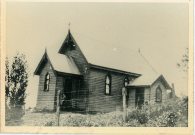
Photograph, Church of England, Olinda
Church of England. Monash Avenue, Olinda. The descriptive text on the reverse of this photograph was hand written by John Lundy-Clarke.Church of England Olinda When the church was built it faced on to the main Mt Dandenong Road but the road was deviated in and the main road section in front of the Village Settlement blocks was named Monash Avenue. The chapel built on Mrs Warner’s land on Mernda Road (later Coonara Road) was shifted in 1936 by Dick Mitlan using Jack Clarkes Ford truck as traction plant. church of england, olinda, monash avenue -
 Flagstaff Hill Maritime Museum and Village
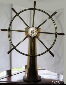
Equipment - Ship's Wheel, John Hastie et al, Early 20th Century
John Hastie Engineer and millwright John Hastie opened small manufacturing works in Greenock in 1845 and 1853 patented the first self-holding steering gear. The firm became known as John, Hastie and Co. Ltd. in 1898 after taking on limited liability status and their main works were at Kilblain Street, Greenock, where they specialised in ships' steering gear. The company also occupied works at Rue End Street, Greenock. Plans of this unit depict a stockyard to the east, with areas for welding; fitting and assembly; flame, cutting and fabrication; and a machine bay. The company was dissolved in 1991. Brown Brothers Brown Bros Rosebank Ironworks made the steering gears for many large ship's, including The Titanic. Andrew Betts Brown the founder was born in 1741 and closely associated with many improvements in marine engineering. He was educated in his native city and served his apprenticeship as an engineer in the locomotive works of the North British Railway Company at St. Margaret's. During his apprenticeship, he attended the evening classes at Watt College. subsequently going to Manchester to study chemistry. He went to London around 1863 and took over an old brewery, which he converted into an engineering works. During his time there he invented an overhead travelling crane, which was used on the construction of Blackfriars Bridge London. He went on to develop plant which used steam and hydraulic power for discharging ships as a result the company was contracted to install this equipment in Hamburg Docks. By around 1870 he continued to construct machinery in London but realised that conditions were more favourable in Edinburgh. He acquired land at Rosebank adjoining the North British Railway Company's line to Granton, and the necessary infrastructure was completed allowing him to finish the Hamburg contract. The works at Rosebank were eventually extended and added to until they became one of the largest engineering works in the East of Scotland. Mr Brown was a member of numerous engineering institutions, the best known at the time being the Institution of Naval Architects. He was also a Fellow of the Royal Society of Edinburgh, a member of the Institute of Mechanical Engineers and of the Institution of Marine Engineers he died in 1906 at the age of 67.An item made by two marine innovators of marine auxiliary machinery, equipment and itemsShip's wheel, brass, attached to brass pillar. The base has six holes in it for securing it in place. Top of the ship's wheel pillar has a brass, adjustable arrow pointer that is positioned over a dial etched into the flat brass surface. The dial reads " PORT STABD". Lines and degrees are marked, with '0' in centre and every 5 degrees, from 0-35, in both Port and Starboard sidesInscription to wheel hub "Brown Brothers & Co. Ltd, Rosebank Ironworks, Edinburgh"flagstaff hill, warrnambool, shipwrecked-coast, flagstaff-hill, flagstaff-hill-maritime-museum, maritime-museum, shipwreck-coast, flagstaff-hill-maritime-village, john hastie, john hastie, andrew betts brown, ships wheel, ship steering gear, marine equipment, instrument, navigation -
 Kew Historical Society Inc
Photograph - Yarra Street, Kew, Ron Setford, 1960
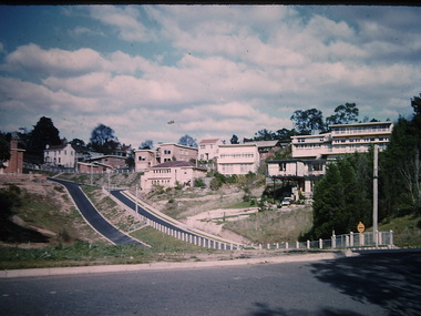
Ron Setford and his wife Grace Setford lived in Tanner Avenue, East Kew, from c.1946 to c.1995. A keen photographer, he recorded the changing face of Kew over a 20 year period. Apart from 30 photographs of built structures and places in Kew dating from 1960 and 1961, 145 of his 35mm colour slides chronicle the development of the Eastern Freeway through the Yarra Valley over a five year period from c.1972 to c.1977. This important collection was donated to the Society by his granddaughter in 2025.This collection of 175 35mm slides is of local and statewide significance, owing to its subject matter, particularly the major development of road transport infrastructure during the 1970s with the construction of the Eastern Freeway. The photographer also took care to annotate and date most of his slides which enable the researcher to pinpoint temporal and spatial locations.Yarra Street was not made a trafficable thoroughfare until October 1956. Until then, the gully was used as a dump, a shortcut to the river, and for communal Guy Fawkes night bonfires. The open landscape in the photo reflects near-total clearing by the original estate owners for grazing livestock. Post-war homes fronting Stawell St dot the landscape. Of particular note are the Broons House (c.1952–54) by Anatol Kagan (top right), and the homes of two architects, Kurt Elsner (c.1950) (middle) and Geoffrey Danne (c.1954) (lower right). Dual carriageways made blocks accessible, but building was difficult due to steeply sloping land and complex drainage easements. Nevertheless, these challenges resulted in highly innovative designs, making Yarra Street the core of the Yarra Boulevard Heritage Precinct."Yarra St Kew"ron setford, photographs -- kew (vic.) -- 1960s, yarra street -- kew (vic.) -
 Flagstaff Hill Maritime Museum and Village
Postcard - Postcard Folder - scenes, George Rose, Rose Stereographic Company, Rose Series Picturesque Views of Warrnambool Australia [Warrnambool], 1880-1942
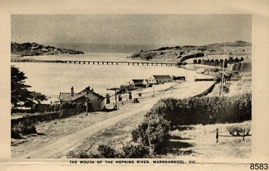
This postcard folder contains lithographs of photographs taken locally by Georg Rose between 1880 and 1942. He reproduced them at his company's premises, the Rose Stereographic Company at Armadale, Victoria. The postcard folder was purchased as a Warrnambool souvenir by the donor's parents around 1945 to 1950. Interestingly, the city on the cover is printed as "Warrambool", which is a location in New South Wales, but the postcards within all have the locations and text of Warrnambool. The photographs include the 'new' concrete bridge, built in 1922 to replace the original bridge, built in 1872. The boathouses belonging to Proudfoots and to Flett/Fanny Nelson are also pictured on the Hopkins River mouth. The twelve photographs included locations connected to other items in our Collection. The photographs are titled: - b. The Avenue and War Memorial. Warrnambool. Vic. c. The Blow-hole. Thunder Point. Warrnambool. Vic. d. Botanical Gardens. Warrnambool. Vic. e. Eagle Rock. Warrnambool. Vic. f. The New Concrete Bridge and Breakwater. Warrnambool. Vic. g. Liebig Street. Warrnambool. Vic. h. Looking to Thunder Point. Warrnambool. Vic. i. The Beach. Warrnambool. Vic. j. Hopkins Falls. Warrnambool. Vic. k. Shelly Beach. Warrnambool. Vic. l. The Mouth of the Hopkins River. Warrnambool. Vic. m. Panorama of Warrnambool. Vic. [Kepler Street towards Presbyterian Church on Spence St] George Rose, 1861-1942: - famous for his Late 19th and early 20th century photography. He was born in Clunes, Victoria, and was in his 20th year when he founded Rose Stereograph Company in 1880. He took the opportunity of a popular trend of the times to produce stereographs, pairs of almost duplicate photographs which appeared to be in 3D when viewed in a handheld stereo viewer. By the 1920s these lost their popularity, so he used his photographic skills to produce cards and postcards of scenes and people. The photographs in this postcard folder were taken between 1880 and 1942 by the renowned Victorian photographer George Rose. The locations match photographs and postcards in our collection that were taken at different times. A comparison between them shows the changes over time in the land and bay, the buildings and other structures, transportation and even the fashions of the times, building the story of our local history.This copy of a postcard folder has a blue-grey textured rectangular card cover with a sketch of a rose on the front along with the name of the postcard series. the location of the series' focus, the producer's details and lines for adding an address. The folded cover contains a long, concertinaed page with six titled photographs on each side, totalling twelve in all. Interestingly, the cover has the location name of "Warrambool", a place in NSW, instead of Warrnambool, the location of all of the photographs inside. The folder contains scenes from Warrnambool and nearby popular areas including Lady Bay, Port of Warrnambool, Warrnambool Breakwater, Viaduct, Merri River Footbridge, the Hopkins River Mouth, with Proudfoot’s and the Fanny Nelson/Flett boathouses. The cover has a sketch of a rose and inscriptions. The photographs for the lithographs were taken prior between 1880 and 1942 by well-known Victorian photographer, George Rose, Rose Stereograph Company of Armadale, Victoria.Image: [Rose with rosebud and leaves] Printed: "Rose Series / Picturesque Views of / WARRAMBOOL / AUSTRALIA" [correct spelling is WARRNAMBOOL] "PUBLISHED BY / ROSE STEREOGRAPH CO / ARMADALE. VIC." Printed lines (3) for an address. Printed rectangle [ ] for attaching a stamp.flagstaff hill maritime museum and village, great ocean road, shipwreck coast, warrnambool, flagstaff hill, flagstaff hill maritime museum, flagstaff hill maritime village, warramble, postcard, postcard folder, warrnambool scenes, picturesque views of warrnambool, picturesque views of warramble, lady bay, port of warrnambool, breakwater, warrnambool breakwater, viaduct, merri river footbridge, merri river suspension bridge, suspension footbridge, merri river mouth, hopkins river mouth, proudfoot's, fanny nelson, nelson's boatsheds, nelson's boathouse, boathouse, hopkins river boathouses, flett's boathouse, flett, george rose, image of a rose, rose series, rose stereograph co, rose stereographic company, lighograph, armadale victoria, lady bay beach, beach scene, lower light, concrete footbridge, 1922 footbridge, viaduct road, rose postcard, new concrete bridge, 1945, 1890, 1922, small footbridge, 1872 footbridge, 1872, merri river estuary, stingray bay, postcards -
 Bacchus Marsh & District Historical Society
Map, Glenvale Estate and Glenmore Estate Land Sales 1909
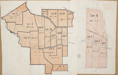
The two land auction plans shown in this record relate to the sale of land from the Glenmore Estate property. The Glenmore property was established by C.J. (Charles James) Griffith and James Moore around 1840. Moore sold his interest to Moelesworth Greene in 1848. Greene was the nephew of the other owner Charles Griffith who died in 1863. From around the 1870s onwards parts of the Estate were subdivided and put up for sale or lease. In subsequent decades more changes in ownership occurred. These two plans document another major sale of the land from the original Glenmore Estate including part of the estate which had become used for dairy farming and was at that time known as the Glenvale Estate. Two single page maps pasted together on a single page of a bound volume of maps. One map shows 15 separate lots of land for sale. The other map which has the words 'Glenvale Estate' at the top of the map shows 4 lots of land for sale. Both parcels of land were originally part of the Glenmore Estate a pastoral holding belonging to C.J. Griffith and James Moore which the began in the Rowsley area south west of Bacchus Marsh in the 1840s. The maps are pasted into a bound volume containing 76 maps or plans in total. High resolution digital image stored on BMDHS computer network. bacchus marsh victoria maps, glenvale estate property, glenvale estate land sales, glenmore estate, glenmore station -
 Flagstaff Hill Maritime Museum and Village
Book - Historical, Warrnambool, Richard Osburne, The History of Warrnambool, 1887
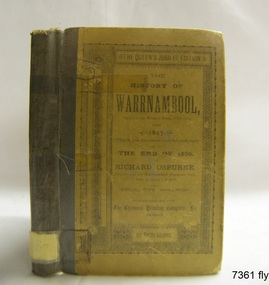
This little book is one of only 1000 books published of the original Queen's Jubilee Edition. It spans fifty years of the history of Warrnambool from the time that the first Government Land Sales commenced. It also deliberately coincides with the 1887 celebrations of Queen Victoria's Jubilee Year of her ascension to the British Throne. The book is an invaluable reference for researchers of local Warrnambool history and has been used as a text book and reference book for local students. The book had two owners before it became part of the Warrnambool Public Library, and when the library closed down, the book was held by the Warrnambool City Council until, in 1974, it was transferred to the newly established Flagstaff Hill Maritime Museum and Village. The author, Richard Osburne, (1825-1895) was born in Australia. He moved to Warrnambool in 1847 as the first local Journalist. In 1851 he founded the Warrnambool Examiner newspaper which he operated until the end of 1880. Osburne was much involved in civic and community affairs of the town, and he set himself the task of recording the history of the city's early pioneers. In the introductory pages of the book the author refers to himself as "The Father of the Warrnambool Press". Only 1,000 copies of this edition of the book were printed. In September 1980 a facsimile edition was printed with the addition of illustrations from the period, an index and relevant annotations by local historian T.A. Wicking (Tom Wicking). This later book was named the Premier Town Edition, due to Warrnambool being awarded the title of Premier Town in Victoria in 1979-82 by the Premier of Victoria; it also received the inaugural award in 1959 and a later award in 1988-91. This book is rare. It is one of only 1000 copies printed, and one of three in the Collection of Flagstaff Hill Maritime Museum and Village. The book was dedicated to the early colonists as well as to the new arrivals by the writer, Richard Osburne, who entitles himself as "The father of the Warrnambool Press". The content of the book is invaluable as a reference for Warrnambool and District's local history in its early colonial and pioneering days. It provides the information that helps in an understanding the foundation that the city was built on, connecting the people of today to the pioneers of the past. The inscriptions of two previous owners of the book, at least one of whom was a local resident, gives additional significance to this copy. The History of Warrnambool: Capital of the Western Ports of Victoria From1847 (when the first Government Land Sales took place) up to the end of 1886, By Richard Osburne, Proprietor of the Warrnambool Examiner from 1851 to the close of 1880. Author: Richard Osburne Publisher: Prahran: The Chronicle Printing & Publishing Company Limited Date: 1887 (MDCCCLXXXVII) Edition: Original: Queen's Jubilee Edition Small book with hard cover and reinforced spine. Dust jacket front has been pasted over front hard cover. The hardcovers are covered with clear adhesive plastic covering. Inscriptions include a typed label on the spine, a stamp at base of the fly page, on the loose page inside front cover, on inside back cover, and two hand written names on the second fly page; Jackson Giblett and G. M. Potter. The first fly page has a message to the readers, as shown in the Inscriptions of this record.Label on spine "R.A. 994.57 OSB" Inscriptions on second fly page: "Jackson Giblett / 1886" and "G.M. Potter, 70 Japan Street" Printed on fly page: "PRICE, FIVE SHILLINGS" Stamp of front end paper: WARRNAMBOOL / PUBLIC LIBRARY", "000336" and in a rectangular border " - - - - - - / WARRNAMBOOL / PUBLIC LIBRARY" First fly page: "THE QUEEN'S JUBILEE EDITION. TO OLD COLONISTS AND YOUNG AUSTRALIANS, OR NEW ARRIVALS, THIS HISTORY OF THE RISE AND PROGRESS OF THE CAPITAL OF WESTERN VICTORIA, IS DEDICATED AS INTERESTING AND USEFUL, BY "THE FATHER OF THE WARRNAMBOOL PRESS" RICHARD OSBURNE." Stamp inside back cover: "WARRNAMBOOL LIBRARY/ Liebig Street / Warrnambool 3280 / (055) 6- 2258"warrnambool, shipwreck coast, flagstaff hill, maritime museum, maritime village, the history of warrnambool, richard osburne, osturne's history of warrnambool, queen's jubilee edition, 1847-1887, warrnambool history, the chronicle printing and publishing company, capital of the western ports of victoria, first government land sales, warrnambool examiner, five shillings, warrnambool's first reporter, warrnambool public library, 1887, 1979, premier town, premier edition, queen's jubliee, queen victoria's jubilee, western ports of victoria, 1847, government land sales, chronicle publishing and printing co., g m potter, 1000 copies, t a wicking, jackson giblett, 1886, japan street, old colonists, young australians, new arrivals, rise and progress, capital of western victoria, interesting and useful, the father of the warrnambool press -
 Flagstaff Hill Maritime Museum and Village
Photograph - Historical, building, Late 19th to early 20th century
The black and white photograph depicts the Lady Bay Lighthouse Complex at Flagstaff Hill, Warrnambool. It was opened on this site in 1871. From left to right, the Chartroom (previously named the Store), Upper Lighthouse, Flagstaff, Lighthouse Keeper's Quarters. The bluestone buildings are facing North on Merri Street. The Harbour Pilot's Lodgings were on the east of the Complex. There are two unknown male figures standing in front of the light-coloured picket fence that encompasses the Complex. The photograph is mounted on card. WARRNAMBOOL'S LADY BAY LIGHTHOUSES In the 1800s ships sailing from England to Australia began to use Bass Strait as a faster route to Melbourne. Small navigation errors led to many tragic shipwrecks. From 1848 lighthouses were operating along Victoria’s southern coast as a guide for sailors. Coastal towns such as Warrnambool grew and the exchange of trade and passengers was of great benefit. However, the uncertain weather changes, relatively shallow waters and treacherous, hidden rocky reefs were not really suitable for a Harbour and in the 1840s and 1850s, there were many shipwrecks in the area, with some even stranded in its Lady Bay harbour. A jetty was built in 1850 and a flagstaff to guide seafarers was placed up high on what became known now as Flagstaff Hill. In November 1857 the Victorian Government recommended that Warrnambool Harbour had beacons and two lighthouses to guide vessels into and out of the Harbour safely. The white light of the Middle Island lighthouse was to be used for the first time on September 1, 1859. The red light of the Beach Lighthouse, a wooden obelisk structure, was first operated on March 25, 1860, but in 1868 this light was ‘discontinued’ due to it being too low. Melbourne’s Department of Public Works decided to relocate the Middle Island Lighthouse Complex - Lighthouse, Keeper’s Quarters, Privy, Store Room and even water tanks - to Flagstaff Hill. The lower obelisk was shortened, and a protruding gallery, railing, and external ladder were added, and the light from the Beach Lighthouse. A green guiding light was erected on the end of the jetty. The transfer of the Complex began in March 1871. Each shaped stone of the lighthouse was carefully numbered, removed then reassembled on Flagstaff Hill. In 1872 the well was sunk behind the Lighthouse Keeper’s Cottage. The Keepers and families had left Middle Island in April and moved to Flagstaff Hill in October 1871. Vessels entering Lady Bay align the Upper and Lower Lighthouse towers during the day and the lights at night. The Upper Lighthouse is a round tower, and the Lower Light is square. The Lighthouses were categorised as harbour lights rather than coastal lights, so they remain under the control of the Victorian Government’s Ports and Harbours section. The lights were originally powered by oil, then acetylene gas, later by electricity, and then converted to solar power in 1988. In 1993 the solar panel was replaced by a battery charger. A decision was made in 1936 to replace the lighthouses’ lights with unattended lights that no longer required Keepers and Assistants. At least 29 Keepers had attended to the lighthouse from its opening in 1859 to when the last official Lightkeepers left In April 1916. The Warrnambool Harbour Board rented out the Quarters from 1916 to 1936. The Board closed down but the rentals continued with other unknown landlords. In the 1970s the Flagstaff Hill Planning Board was set up under the chairmanship of John Lindsay. The Board was to make recommendations to the Warrnambool City Council regarding using the buildings and the rest of the Crown Land on the site. The Flagstaff Hill Maritime Village opened in 1975 and began renovating the Cottage in stages, during which time evidence of a 1920s fire was found in the eastern section of the cottage. Additions of a porch on the west and a washroom on the east were made in the 1980s. The western part of the building is now a Shipwreck Museum and the east has returned to a late 19th-century Lighthouse Keeper’s cottage and includes the screen made by Assistant Lighthouse Keeper Thomas Hope in the late 19th century. He served as Assistant Keeper in Warrnambool for two periods.The Warrnambool Lighthouse Complex is now listed on the Victorian Heritage Register, H1520, for being of historical, scientific (technological) and architectural significance to the State of Victoria. The Complex is significant as an example of early colonial development. The buildings are significant for their connection with the important navigational function of the Lighthouses, a function still being performed to this day. The buildings are also significant as an example of structures designed and works carried out by the Public Works Department in Victoria in the mid-to-late 19th century. The structures still stand strong. Photograph; Warrnambool Lighthouse Keeper's cottage, lighthouse, flagstaff and chartroom at Flagstaff Hill, and a light-coloured picket fence with gate. Two male figures are in front of the fence. Black and white print glued to a yellow card. The inscription is indecipherable. The right side of the cottage has a built-in, enclosed addition.Ink stamped in lower right hand corner, too faded to be legible.flagstaff hill, flagstaff hill maritime museum, flagstaff hill maritime village, warrnambool, maritime museum, shipwreck coast, lighthouse keeper's cottage, lighthouse residence, lighthouse, chart room, quarters, privy, middle island, beach lighthouse, obelisk, lighthouse complex, lady bay complex, warrnambool port, warrnambool harbour, lady bay, keepers, lighthouse keeper, upper lighthouse, lower lighthouse, assistant keeper, ports and harbours, cottage