Showing 2994 items matching "parks victoria"
-
 St Kilda Historical Society
Photograph - Photo map, 30/01/1960
One of a series of photo-maps produced for the Department of Crown Lands and Survey (1857-1983). For correlation with a current map, and access to other historical photo maps of Victoria, see the Historic Photo-Maps Index published by the Department of Environment, Land, Water and Planning at https://services.land.vic.gov.au/DELWPmaps/historical-photomaps/Black and white aerial photographVic 1091-110 Melbourne & Metropolitan Project Run 23East 30.1.60 Lens 10" 8.200elwood, elsternwick, elsternwick park, ripponlea, st kilda east, caulfield, balaclava, 1960 -
 St Kilda Historical Society
Photograph - Photo map, 30/01/1960
One of a series of photo-maps produced for the Department of Crown Lands and Survey (1857-1983). For correlation with a current map, and access to other historical photo maps of Victoria, see the Historic Photo-Maps Index published by the Department of Environment, Land, Water and Planning at https://services.land.vic.gov.au/DELWPmaps/historical-photomaps/Black and white aerial photographVic 1091-1 Melbourne & Metropolitan Project Run 24East 30.1.60 Lens 10" 8.200elwood, elwood beach, elwood park, 1960 -
 St Kilda Historical Society
Photograph - Photo map, 30/01/1960
One of a series of photo-maps produced for the Department of Crown Lands and Survey (1857-1983). For correlation with a current map, and access to other historical photo maps of Victoria, see the Historic Photo-Maps Index published by the Department of Environment, Land, Water and Planning at https://services.land.vic.gov.au/DELWPmaps/historical-photomaps/Black and white aerial photographVic 1091-2 Melbourne & Metropolitan Project Run 24East 30.1.60 Lens 10" 8.200elwood, elwood park, elwood beach, elsternwick park, 1960 -
 St Kilda Historical Society
Photograph - Photo map, 3/3/1964
One of a series of photo-maps produced for the Department of Crown Lands and Survey (1857-1983). For correlation with a current map, and access to other historical photo maps of Victoria, see the Historic Photo-Maps Index published by the Department of Environment, Land, Water and Planning at https://services.land.vic.gov.au/DELWPmaps/historical-photomaps/Black and white aerial photographVic 1833 Melbourne 1963 Project Run 15 3.3.64 Lens 205 152.70 M/M 5.150 56prahran, fawkner park, south yarra, albert park, 1964 -
 St Kilda Historical Society
Photograph - Photo map, 14/12/1963
One of a series of photo-maps produced for the Department of Crown Lands and Survey (1857-1983). For correlation with a current map, and access to other historical photo maps of Victoria, see the Historic Photo-Maps Index published by the Department of Environment, Land, Water and Planning at https://services.land.vic.gov.au/DELWPmaps/historical-photomaps/Black and white aerial photographVic 1807 Melbourne 1963 Project Run 16 14.12.63 Lens 205 152.70 M/M 5.150 179st kilda, prahran, albert park, st kilda east, balaclava, 1963 -
 St Kilda Historical Society
Photograph - Photo map, 14/12/1963
One of a series of photo-maps produced for the Department of Crown Lands and Survey (1857-1983). For correlation with a current map, and access to other historical photo maps of Victoria, see the Historic Photo-Maps Index published by the Department of Environment, Land, Water and Planning at https://services.land.vic.gov.au/DELWPmaps/historical-photomaps/Black and white aerial photographVic 1806 Melbourne 1964 Project Run 18 14.12.63 Lens 205 152.70 M/M 5.150 161elsternwick, elsternwick park, elwood, elwood canal, elwood beach, elwood park, 1963 -
 St Kilda Historical Society
Photograph - Photo map, 12/04/1966
One of a series of photo-maps produced for the Department of Crown Lands and Survey (1857-1983). For correlation with a current map, and access to other historical photo maps of Victoria, see the Historic Photo-Maps Index published by the Department of Environment, Land, Water and Planning at https://services.land.vic.gov.au/DELWPmaps/historical-photomaps/Black and white aerial photographVic 1933 Melbourne 1966 Project Run 12 12.4.66 Lens 122 151.75MM 9.800 152st kilda, st kilda pier, st kilda marina, albert park, fawkner park, windsor, south yarra, prahran, st kilda west, middle park, st kilda beach, 1966 -
 St Kilda Historical Society
Photograph - Photo map, 08/02/1966
One of a series of photo-maps produced for the Department of Crown Lands and Survey (1857-1983). For correlation with a current map, and access to other historical photo maps of Victoria, see the Historic Photo-Maps Index published by the Department of Environment, Land, Water and Planning at https://services.land.vic.gov.au/DELWPmaps/historical-photomaps/Black and white aerial photographVic 1916 Melbourne 1966 Project Run 13 E 8.2.66 Lens 122 151.75MM 9.800 113st kilda, st kilda marina, st kilda beach, point ormond, elwood, elwood beach, elwood park, 1966 -
 St Kilda Historical Society
Photograph - Photo map, 08/02/1966
One of a series of photo-maps produced for the Department of Crown Lands and Survey (1857-1983). For correlation with a current map, and access to other historical photo maps of Victoria, see the Historic Photo-Maps Index published by the Department of Environment, Land, Water and Planning at https://services.land.vic.gov.au/DELWPmaps/historical-photomaps/Black and white aerial photographVic 1916 Melbourne 1966 Project Run 13 E 8.2.66 Lens 122 151.75MM 9.800 111st kilda, balaclava, caulfield, caulfield north, st kilda east, elsternwick, elsterwick park, elwood park, elwood canal, elwood beach, ripponlea, 1966 -
 St Kilda Historical Society
Photograph - Photo map, 11/01/1968
One of a series of photo-maps produced for the Department of Crown Lands and Survey (1857-1983). For correlation with a current map, and access to other historical photo maps of Victoria, see the Historic Photo-Maps Index published by the Department of Environment, Land, Water and Planning at https://services.land.vic.gov.au/DELWPmaps/historical-photomaps/Black and white aerial photographVic 2132 State Aerial Survey Melbourne 1968 Proj Run 27E 11.1.68 5100 ASL 65caulfield north, caulfield park, armadale, malvern, 1968 -
 St Kilda Historical Society
Photograph - Photo map, 11/01/1968
One of a series of photo-maps produced for the Department of Crown Lands and Survey (1857-1983). For correlation with a current map, and access to other historical photo maps of Victoria, see the Historic Photo-Maps Index published by the Department of Environment, Land, Water and Planning at https://services.land.vic.gov.au/DELWPmaps/historical-photomaps/Black and white aerial photographVic 2132 State Aerial Survey Melbourne 1968 Proj Run 27E 11.1.68 5100 ASL 67st kilda east, st kilda cemetery, caulfield north, alma park, balaclava, armadale, 1968 -
 St Kilda Historical Society
Photograph - Photo map, 13/01/1968
One of a series of photo-maps produced for the Department of Crown Lands and Survey (1857-1983). For correlation with a current map, and access to other historical photo maps of Victoria, see the Historic Photo-Maps Index published by the Department of Environment, Land, Water and Planning at https://services.land.vic.gov.au/DELWPmaps/historical-photomaps/Black and white aerial photograph2138 State Aerial Survey Melbourne 1968 Proj. Run 26 13.1.68 5100 ASL 203st kilda west, albert park, fawkner park, south yarra, prahran, windsor, 1968 -
 St Kilda Historical Society
Photograph - Photo map, 11/01/1968
One of a series of photo-maps produced for the Department of Crown Lands and Survey (1857-1983). For correlation with a current map, and access to other historical photo maps of Victoria, see the Historic Photo-Maps Index published by the Department of Environment, Land, Water and Planning at https://services.land.vic.gov.au/DELWPmaps/historical-photomaps/Black and white aerial photographVic 2132 State Aerial Survey Melbourne 1968 Proj. Run 27E 11.1.68 5100 ASL 69st kilda, albert park, st kilda east, st kilda beach, alma park, windsor, prahran, 1968 -
 St Kilda Historical Society
Photograph - Photo map, 11/01/1968
One of a series of photo-maps produced for the Department of Crown Lands and Survey (1857-1983). For correlation with a current map, and access to other historical photo maps of Victoria, see the Historic Photo-Maps Index published by the Department of Environment, Land, Water and Planning at https://services.land.vic.gov.au/DELWPmaps/historical-photomaps/Black and white aerial photographVic 2132 State Aerial Survey Melbourne 1968 Proj. Run 29E 11.1.68 5100 ASL 194elwood, elwood beach, elwood park, elsternwick park, ripponlea, elwood canal, balaclava, st kilda, 1968 -
 St Kilda Historical Society
Photograph - Photo map, 11/01/1968
One of a series of photo-maps produced for the Department of Crown Lands and Survey (1857-1983). For correlation with a current map, and access to other historical photo maps of Victoria, see the Historic Photo-Maps Index published by the Department of Environment, Land, Water and Planning at https://services.land.vic.gov.au/DELWPmaps/historical-photomaps/Black and white aerial photographVic 2132 State Aerial Survey Melbourne 1968 Proj. Run 27E 11.1.68 5100 ASLst kilda, st kilda west, st kilda pier, catani gardens, st kilda beach, albert park, 1968 -
 St Kilda Historical Society
Photograph - Photo map, 11/01/1968
One of a series of photo-maps produced for the Department of Crown Lands and Survey (1857-1983). For correlation with a current map, and access to other historical photo maps of Victoria, see the Historic Photo-Maps Index published by the Department of Environment, Land, Water and Planning at https://services.land.vic.gov.au/DELWPmaps/historical-photomaps/Black and white aerial photographVic 2132 State Aerial Survey Melbourne 1968 Proj. Run 29E 11.1.68 5100 ASL 196elwood, elwood park, elwood canal, elwood beach, st kilda marina, mc moran reserve, point ormond, 1968 -
 St Kilda Historical Society
Photograph - Photo map, Department of Crown Lands and Survey (1857-1983), 22/01/1970
One of a series of photo-maps produced for the Department of Crown Lands and Survey (1857-1983). For correlation with a current map, and access to other historical photo maps of Victoria, see the Historic Photo-Maps Index published by the Department of Environment, Land, Water and Planning at https://services.land.vic.gov.au/DELWPmaps/historical-photomaps/Black and white aerial photographVic 2358 Department of Crown Lands and Survey Victoria,.© Melbourne 1970 Project Run 42E 22.1.70 5,100 ASL 77st kilda, st kilda east, st kilda marina, elwood, elwood canal, elsternwick park, point ormond, balaclava, mc moran reserve, ripponlea, st kilda botanical gardens, peanut farm, 1970 -
 St Kilda Historical Society
Photograph - Photo map, Department of Crown Lands and Survey, 22/01/1970
One of a series of photo-maps produced for the Department of Crown Lands and Survey (1857-1983). For correlation with a current map, and access to other historical photo maps of Victoria, see the Historic Photo-Maps Index published by the Department of Environment, Land, Water and Planning at https://services.land.vic.gov.au/DELWPmaps/historical-photomaps/Black and white aerial photographVic 2358 Department of Crown Lands and Survey Victoria,.© Melbourne 1970 Project Run 43E 22.1.70 5,100 ASL 208elwood, elwood beach, point ormond, elwood park, elwood canal, mc moran reserve, 1970 -
 St Kilda Historical Society
Photograph - Photo map, Department of Crown Lands and Survey, 22/01/1970
One of a series of photo-maps produced for the Department of Crown Lands and Survey (1857-1983). For correlation with a current map, and access to other historical photo maps of Victoria, see the Historic Photo-Maps Index published by the Department of Environment, Land, Water and Planning at https://services.land.vic.gov.au/DELWPmaps/historical-photomaps/Black and white aerial photographCONTROLLED Vic 2358 Department of Crown Lands and Survey Victoria,.© Melbourne 1970 Project Run 41E 22.1.70 5,100 ASL 66st kilda, albert park, st kilda west, catani gardens, st kilda botanical gardens, st kilda pier, st kilda beach, 1970 -
 St Kilda Historical Society
Photograph - Photo map, 14/12/1963
One of a series of photo-maps produced for the Department of Crown Lands and Survey (1857-1983). For correlation with a current map, and access to other historical photo maps of Victoria, see the Historic Photo-Maps Index published by the Department of Environment, Land, Water and Planning at https://services.land.vic.gov.au/DELWPmaps/historical-photomaps/Black and white aerial photographVic 1807 Melbourne 1963 Project Run 16 14.12.1963 Lens 205 152.70 M/M 5.150 177st kilda, st kilda pier, catani gardens, middle park, albert park, st kilda west, st kilda beach, 1963 -
 St Kilda Historical Society
Photograph - Photo map, Department of Crown Lands and Survey, 22/01/1970
One of a series of photo-maps produced for the Department of Crown Lands and Survey (1857-1983). For correlation with a current map, and access to other historical photo maps of Victoria, see the Historic Photo-Maps Index published by the Department of Environment, Land, Water and Planning at https://services.land.vic.gov.au/DELWPmaps/historical-photomaps/Black and white aerial photographVic 2358 Department of Crown Lands and Survey Victoria,.© Melbourne 1970 Project Run 41E 22.1.70 5,100 ASL 64st kilda, st kilda cemetery, balaclava, st kilda east, windsor, caulfield north, alma park, 1970 -
 St Kilda Historical Society
Photograph - Photo map, Department of Crown Lands and Survey, 08/01/1970
One of a series of photo-maps produced for the Department of Crown Lands and Survey (1857-1983). For correlation with a current map, and access to other historical photo maps of Victoria, see the Historic Photo-Maps Index published by the Department of Environment, Land, Water and Planning at https://services.land.vic.gov.au/DELWPmaps/historical-photomaps/Black and white arial photographVic 2345 Department of Crown Lands and Survey Victoria,.© Melbourne 1970 Project Run 40 8.1.70 5,100 ASL 77albert park, fawkner park, south yarra, middle park, prahran, windsor, st kilda, st kilda west, 1970 -
 St Kilda Historical Society
Photograph - Photo map, 22/01/1970
One of a series of photo-maps produced for the Department of Crown Lands and Survey (1857-1983). For correlation with a current map, and access to other historical photo maps of Victoria, see the Historic Photo-Maps Index published by the Department of Environment, Land, Water and Planning at https://services.land.vic.gov.au/DELWPmaps/historical-photomaps/Black and white aerial photographVic 2358 Department of Crown Lands and Survey Victoria,.© Melbourne 1970 Project Run 43E 22.1.70 5,100 ASL 206elwood, elsternwick, elsternwick park, 1970 -
 St Kilda Historical Society
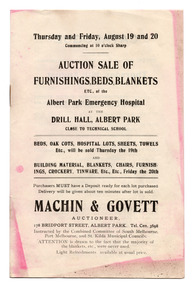
Ephemera - Catalogue, Auction Sale of Furnishings, Beds, Blankets etc of the Albert Park Emergency Hospital, 1920
Catalogue for the auction of items of the Albert Park Emergency Hospital at the Drill Hall, 178 Bridport Street, Albert Park, under instruction of a combined committee of the South Melbourne, Port Melbourne and St Kilda Councils. The full date is not given. During the Spanish Flu epidemic in 1919, 34 emergency hospitals were created in Victoria because the existing hospitals were unable to cope with the demand for care. An Epidemic Hospital was set up in the Drill Room at Albert Park, the expenses shared between the South Melbourne, Port Melbourne and St. Kilda Councils, to serve influenza patients from those local government areas. Each Council had three representatives on the Board of Management. Like the other emergency hospitals, the Albert Park hospital operated only for a short time while the epidemic was at its height. As noted in the catalogue, 'the majority of the blankets, etc. were never used.' It is possible that items advertised in this catalogue were auctioned on Thursday 19 August and Friday 20 August 1920. The items for sale include hospital equipment, furniture, sheets, pillows, towels, building materials, blankets, crockery, cutlery, clothing, furnishings.Document of 3 sheets of white paper (discoloured with age), folded and stapled and printed in blackalbert park emergency hospital, spanish flu, spanish influenza -
 Puffing Billy Railway
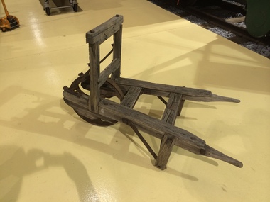
Wheelbarrow - Fritsch, Holzer & Company Brickworks
Used at the brickworks of Fritsch, Holzer & Company of Hawthorn to transport bricks and materials around the works. Fritsch Holzer Originally the company was known as the Upper Hawthorn Brick Company Ltd. It was started by brothers Johann, Martin and Anton Holzer and Gustav Augustus Fritsch. Fritsch had previously been a brick maker in Abbotsford, before moving to Hawthorn. Each had a brick works that operated next door to each other and the two works merged in 1883 to form the largest brick making company in Victoria. At its peak, they employed around eighty people and were making over 250,000 bricks per week. The depression of the 1890s caused a drastic downturn in building. Bricks were not being sold and staff laid off. The company nearly collapsed. To stave off the inevitable, in 1896 a brick co-operative was formed with Hoffman Patent Steam Brick Co., Northcote Brick Co. Ltd., New Northcote Brick Co. Ltd., Chas. Butler & Son and Fritsch, Holzer and Company. Bricks were sold throughout Victoria as the company supplied the State Government, more particularly the building of schools. They continued making bricks until the early 1970s when the works closed. The former site is now the “Ftritsch Holzer Park. The local Council purchased the 14 acre site in 1972 for $1,060.000 and used it for landfill. The site became a park in 1995. Info from Victorian Heritage Bricks, Brick Makers and Brick Works http://rameking2.blogspot.com.au/2013/12/fritsch-holzer.htmlHistoric - Narrow Gauge Industrial Brickworks Equipment - Victoria, AustraliaWheelbarrow - Timber frame with Iron bracing and wheel.puffing billy, pbr,, wheelbarrow - fritsch, holzer & company brickworks, fritsch, holzer & company -
 Puffing Billy Railway
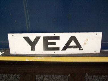
Station Sign - Yea
Station Sign - Yea Yea Station Opened 16 November 1883 Closed 8 November 1978 Yea is a former railway station in Yea, Victoria, Australia. The tracks have been removed and the reserve has been turned into The Yea Railway Park consisting of the historic railway station and eleven acres of parkland. It has a picnic shelter, barbecue, toilets, playground, skatepark, walking track, community reserve and includes Rotary Park. The station building houses Blackthorn Textiles (a privately run craft shop). Also on the site are the former goods sheds which are available for hire for varied functions. The Yea Country Market is held in the park on the first Saturday of each month and local artists hold an exhibition and sale in the goods sheds each Easter. The site is listed on the Victorian Heritage Register ref: https://en.wikipedia.org/wiki/Yea_railway_station photo at http://vhd.heritagecouncil.vic.gov.au/vhd-images/places/000/078/092.jpg Historic - Victorian Railways Station sign used at Yea StationStation Sign - Yea Metal rectangle Station Name Sign with white enamel back ground and black lettersYeapuffing billy, station sign, yea station -
 Puffing Billy Railway
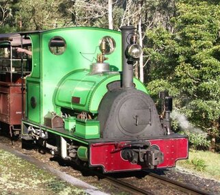
Peckett, 1711 Peckett Steam Locomotive, 1926
Steam Locomotive - 1711 Peckett “Sir John Grice” Date built - 1926 Locomotive type ; Cranmore Original owner - Metropolitan Gas Coy., West Melbourne Original gauge - 762mm Withdrawn - 1941 Next owner - Whistle Stop Amusement Park, Frankston Built in 1926 for the West Melbourne site of the Metropolitan Gas Company, and issued to traffic the same year this saddle tank locomotive was named “Sir John Grice” in 1928. It was withdrawn from traffic in 1941 and stored until sold privately in 1962. In 1965 it was sold again and went to the Whistle Stop Amusement Park in Frankston and again stored until bought at auction by the Puffing Billy Preservation Society in 1974 and put on static display in the Steam Museum. Restoration started in 1978 and it was returned to service in 1981 painted light green with yellow lining. It is temporarily renamed “Thomas the Tank Engine” with a fibreglass “Thomas” body cover each time it appears in the “Thomas the Tank Engine” shows at Gembrook station.Historic - Industrial Narrow Gauge Railway - Steam Locomotive used at the Metropolitan Gas Coy., West Melbourne, Victoria, AustraliaSteam Locomotive made of steel, wrought iron Peckettpeckett “sir john grice”, 1711 peckett, puffing billy, steam locomotive, industrial narrow gauge railway, metropolitan gas coy., west melbourne -
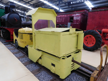 Puffing Billy Railway
Greenbat Battery Loco, Greenwood & Batley ltd
... Munitions factory - Deep park, Victoria, Australia puffing billy ...Greenbat Battery Loco Built by Greenwood & Batley Ltd Builders No. 420363/2 This Greenbat Battery Loco has been loaned to the Museum by the Walhalla Goldfields Railway, who had acquired it in 2013 along with a large quantity of narrow gauge trollies and light rail from Orica’s now closed munitions factory in Melbourne’s western suburbs. The trolley on display was one of two in use from the 1970s. Orica - Deer Park Munitions factory Orica Deer Park in Melbourne’s west has been used since circa 1875 for various forms of manufacturing and storage of chemicals. Although the site is bounded by Ballarat Road, Station Street, Tilburn Road and the Western Ring Road, the current entry point for industrial operations is situated at Gate 6 off Tilburn Road. Operations include: • a specialty chemicals facility producing products for mining services operations • quarry services • other chemical manufacture activities. The Deer Park factory complex is of historical significance as the location of the first plant for the manufacture of high explosives in Australia and has been, for its entire history, the most important, if not only, commercial manufacturer of high explosives in Australia. It commenced operation under the importer Jones Scott and Co, and then the Australian Lithofracteur Company (Krebs Patent), a rival to Nobel's dynamite patent. The factory was producing nitro-glycerine based explosives in Australia only a couple of years after Nobel's Ardeer factory began operating in Scotland. The explosives factories complex is of historical significance for the association with the Australian Lithofracteur Company, Australian Explosives and Chemicals, the Nobel company and later ICIANZ, which grew to become one of the largest explosives, chemical and plastics manufacturers in Australia. It was the pioneer of the industry and retained its dominance through monopolistic practices, taking over most of its competitors in the Australasian region. Substantial parts of the pre-Second World War layout of the site remain which, with a number of significant buildings dating back to the 1920s and '30s, indicate past and present processes of manufacturing, the necessary safety measures required and the integrated nature of the explosives and chemical industry. The narrow gauge tramway, which ran through the explosives section, was a rare survivor of nineteenth century materials-handling methods into the 21st Century. Greenwood & Batley were a large engineering manufacturer with a wide range of products, including armaments, electrical engineering, and printing and milling machinery. They also produced a range of battery-electric railway locomotives under the brand name Greenbat. The works was in Armley, Leeds, UK. Greenbat was the trade name for the railway locomotives built by Greenwood & Batley. The company specialised in electric locomotives, particularly battery-powered types for use in mines and other hazardous environments. Historic - Industrial Narrow Gauge Railway - Battery Locomotive - Orica - Deer Park Munitions factory - Deep park, Victoria, Australia Battery Locomotive - made of iron puffing billy, greenbat battery loco, battery locomotive, industrial narrow gauge railway, orica - deer park munitions factory -
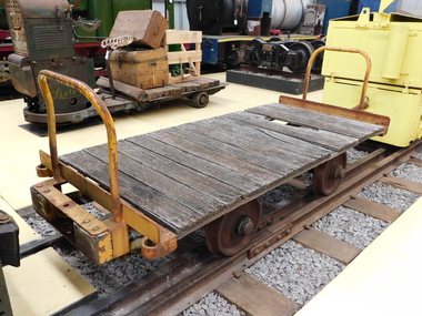 Puffing Billy Railway
Explosives Wagon, unkown
... Munitions factory, Deer park, Victoria, Australia wagon for carrying ...This 2 foot 6 inch (762mm) gauge wagon was used for carrying explosives and was used with the Greenbat Battery loco. It was donated to the Walhalla Goldfields Railway on long term loan in 2013 along with a large quantity of narrow gauge trollies and light rail from Orica’s now closed munitions factory in Melbourne’s western suburbs. Orica - Deer Park Munitions factory Orica Deer Park in Melbourne’s west has been used since circa 1875 for various forms of manufacturing and storage of chemicals. Although the site is bounded by Ballarat Road, Station Street, Tilburn Road and the Western Ring Road, the current entry point for industrial operations is situated at Gate 6 of Tilburn Road. Operations include: • a specialty chemicals facility producing products for mining services operations • quarry services • other chemical manufacture activities. The Deer Park factory complex The factory complex is of historical significance for the major role it played in Australia's manufacturing and mining industries through the development of progressively more efficient and safer explosives. It also contributed to wartime production in ammunition, initiators and the development of synthetic ammonia production and construction of the Defence Explosives Annexe No 5 (later the Albion Explosives Factory) during World War Two. The factory complex is also of technical significance for the unusual and specialised design of many of the buildings and structures, both in the layout of the works and the individual design of buildings. Blast protection and safety measures such as mounds around the buildings, 'cleanways' and buffer zones between production areas were employed extensively. A characteristic of many production buildings was the elimination of cavities where explosive compounds could lodge. The combination of concrete barriers and light-weight construction was designed to direct explosion debris away from operators or other buildings. The narrow gauge tramway, which ran through the explosives section, is a rare survivor of nineteenth century materials-handling methods. Historic - Industrial Narrow Gauge Railway - Wagon for carrying Explosives at the Orica - Deer Park Munitions factory, Deer park, Victoria, Australia Wagon for carrying explosives made from Timber and steelwagon for carrying explosives, puffing billy, industrial narrow gauge railway, orica - deer park munitions factory, explosives wagon -
 Tatura Irrigation & Wartime Camps Museum
CD, Susan Morey, Cussen Park Tatura Victoria, 2007/2008
... Cussen Park Tatura Victoria.... Cussen Park Tatura Victoria CD Susan Morey ...Photographs taken by Susan Morey at Cussen Park, Tatura of bird life in the Park between November 2007 and February 2008.Pale blue coloured CD, silver and black text. Clear and black plastic case.susan morey, cussen park, birds in tatura