Showing 11155 items matching "planning "
-
 Warrnambool and District Historical Society Inc.
Administrative record (Collection) - Warrnambool City Council Administrative Records, Warrnambool City Council Officers, 1990s
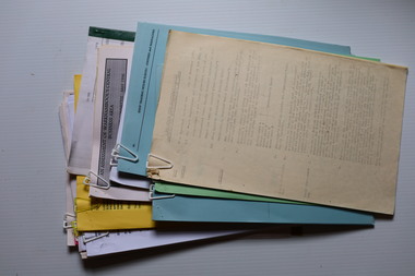
Warrnambool City Council Records collected by a member of a Council Advisory Committee.Collection of Warrnambool City Council records of the 1990sIn folders and archival envelopes in an A3 archival boxTwo A3 archival envelopes containing information on Foreshore etc., five booklets containing reports on City Plans, Council Strategies etc and 15 Reports (Shop Trading, Coastal Wetlands, Foreshore, Landcare etc)warrnambool city council, warrnambool city council strategies and planswarrnambool city council, warrnambool city council strategies and plans -
 Bendigo Historical Society Inc.
Legal record - Land Register
Land register for duration 1924 to 1951 (!!). Register contains plans of Land sales for a broad area of Central Victorian Parish / Counties. Register has a stiff blue card cover originally bound with light brown leather spine and corners, presently in a dire condition with cover damaged and loose; plans also folded and damaged. Plans inserted as drawn plans within the register, later plans are included on tracing, paper and linen - in various degrees of condition / damage.land register, central victoria -
 Bendigo Historical Society Inc.
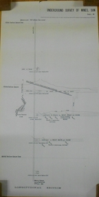
Document - MARKS COLLECTION: NEW CHUM LINE OF REEF MAP
Plan (copy) of New Chum Line of Reef. Plan has been copied in two sections. On top of plan 'Underground survey of mines Sandhurst, New Chum Line of Reef', plan shows longitudinal and cross section views of the workings on the reef. Shaft No. 76 marked. Datum line on top indicates 750' above sea level, on bottom of plan, bottom of shaft 2022.24 below sill. Drawn by Arthur Everett, Mining Department, Melbourne, 1884.bendigo, mining, new chum line of reef -
 Melbourne Tram Museum
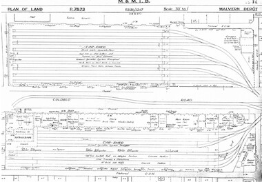
Drawing, Melbourne & Metropolitan Tramways Board (MMTB), "Malvern Depot", c1938
Set of three photocopied plans or drawings on A3 sheets of "Malvern Depot" - 15-3-1937 .1 - P7873 - Plan showing details of car sheds .2 - P7894 - Plan of Land showing overall site plan .3 - P8342 - showing details of buildings, including offices, Club Rooms in Stanhope St, No. 28 Stanhope St and sub-station.trams, tramways, drawings, depots, property, substation, malvern depot -
 Bendigo Historical Society Inc.
Plan - MARKS COLLECTION: HARRISON'S QUARTZ PULVERISER PLAN
Sepia coloured heavy paper, plans drawn in black pen. Written on top of plan: Youngman Harrison's Patent, 22 March 1875' Plans contain drawings labelled as copper pages, roller, grating, drag. Plan has been tightly rolled. On outer edge, written in black pen Harrison Quartz Tailings Pulveriser (last word unclear)equipment, quartz tailing pulverisor, gold mining, lansell -
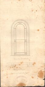 Bendigo Historical Society Inc.
Document - MARKS COLLECTION: GROUND PLAN SHOWING WINDOW OF FORTUNA
Heavy parchment plan showing line drawing of arched window. Under window 'inside elevation', ground plan, scale one inch to the foot written in black pen. On bottom of plan: purple ink stamp 'Vahland & Getzschmann, Architects, Sandhurst'.Vahland & Getzschmann, Architects, Sandhurst.bendigo, house, fortuna villa -
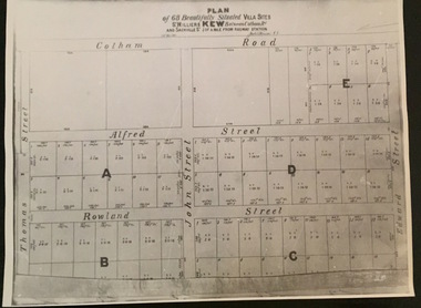 Kew Historical Society Inc
Plan - Subdivision Plan, Plan of 68 beautifully situated villa sites: St Helliers Kew, 196-1973
This work forms part of the collection assembled by the historian Dorothy Rogers, that was donated to the Kew Historical Society by her son John Rogers in 2015. The manuscripts, photographs, maps, and documents were sourced by her from both family and local collections or produced as references for her print publications. Many were directly used by Rogers in writing ‘Lovely Old Homes of Kew’ (1961) and 'A History of Kew' (1973), or the numerous articles on local history that she produced for suburban newspapers. Most of the photographs in the collection include detailed annotations in her hand. The Rogers Collection provides a comprehensive insight into the working habits of a historian in the 1960s and 1970s. Together it forms the largest privately-donated collection within the archives of the Kew Historical Society.A photographic reproduction of a plan in the Vale Collection of the State Library of Victoria. The plan shows lots in a subdivision bordered by Cotham Road; Edward Street; Sackville Street and Thomas Street. The undated plan does not include the land occupied by Bella Vista and Charleville.subdivision plans -- kew (vic), st helliers estate -
 Kew Historical Society Inc
Plan, Gwen McWilliam, Annotated Plan of the City of Camberwell, 1993
Gwen Barton McWilliam (nee: Nelson), OAM, BA (1933- ). Gwen McWilliam is well known as an authority on the history of Boroondara and the author of a large number of books and pamphlets about the City. She was awarded the medal of the Order of Australia in 2001 ‘for service to the community of Hawthorn and district, particularly through the research, documentation and publication of its history.’ Plan of Camberwell, Canterbury, Balwyn and Surrey Hills, forming part of a larger plan of the City of Boroondara, including annotations by the historian Gwen McWilliam, identifying significant landholdings, subdivisions and key dates. The plan was donated to the Kew Historical Society by Ms McWilliam. city of boroondara, subdivisions - camberwell, subdivisions - balwyn, subdivisions - surrey hills, subdivisions - canterbury, gwen mcwilliam -
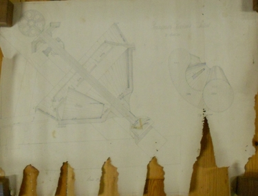
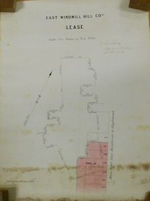 Bendigo Historical Society Inc.
Plan - MARKS COLLECTION: EAST WINDMILL HILL CO LEASE PLAN
Plan on heavy paper. On top of plan ' East Windmill Hill Coy's Lease, scale one inch to one chain' Signed in ink by Thomas McNulty (?) Mining Engineer. On RH side of plan written 'Main Road from Sandhurst to Eaglehawk'.bendigo, mining, east windmill hill lease co -
 Kew Historical Society Inc
Plan - Subdivision Plan, Plan of Subdivision of Part of Crown Portion 84 / Parish of Boroondara / County of Bourke / Lodged Plan No. 2217, Twentieth Century
Pru Sanderson, in her groundbreaking ‘City of Kew Urban Conservation Study : Volume 2 - Development History’ (1988), summarised the periods of urban development and subdivisions of land in Kew. The periods that she identified included 1845-1880, 1880-1893, 1893-1921, 1921-1933, 1933-1943, and Post-War Development. These periods were selected as they represented periods of rapid growth or decline in urban development. An obvious starting point for Sanderson’s groupings involved population growth and the associated economic cycles. These cycles also highlighted urban expansion onto land that was predominantly rural, although in other cases it represented the decline and breakup of large estates. A number of the plans in the Kew Historical Society’s collection can also be found in other collections, such as those of the State Library of Victoria and the Boroondara Library Service. A number are however unique to the collection.The Kew Historical Society collection includes almost 100 subdivision plans pertaining to suburbs of the City of Melbourne. Most of these are of Kew, Kew East or Studley Park, although a smaller number are plans of Camberwell, Deepdene, Balwyn and Hawthorn. It is believed that the majority of the plans were gifted to the Society by persons connected with the real estate firm - J. R. Mathers and McMillan, 136 Cotham Road, Kew. The Plans in the collection are rarely in pristine form, being working plans on which the agent would write notes and record lots sold and the prices of these. The subdivision plans are historically significant examples of the growth of urban Melbourne from the beginning of the 20th Century up until the 1980s. A number of the plans are double-sided and often include a photograph on the reverse. A number of the latter are by noted photographers such as J.E. Barnes.Undated Plan of Subdivision of Crown Portion 84 in what is now Kew. The area shown is bordered by Burke Road, Harp Road, Arglye Road and Normanby Road.subdivision plans -- kew (vic), harp road, burke road, normanby road, lady loch's drive, gladstone street, second avenue, first avenue -
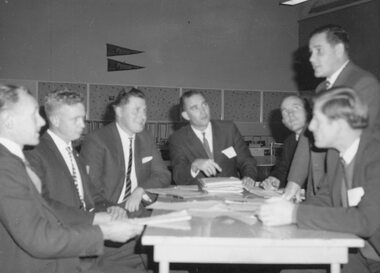 Ringwood and District Historical Society
Photograph, Jaycee's Community Service Commission discussing plans for Jaycee Week
Written on back of photograph, "Jaycee's Community Service Commission discussing plans for Jaycee Week". [no date] -
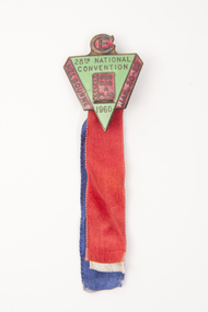 Uniting Church Archives - Synod of Victoria
Badge
Green and red triangular shaped badge on red, blue and white ribbons."CE" "20th National Convention 1960" "God has a plan" "Melbourne Jan - 20 - 28" -
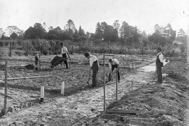 University of Melbourne, Burnley Campus Archives
Photograph - Black and white print, Noelle Kendall (Vaughan), Reconstructing the Vegetable Garden May 1918, 1918
2 copies black and white photograph. Copy of photograph in Noelle Kendall's (née Vaughan) photograph album (B09.0003). 3 men and a child working in the vegetable section of the Orchard. Wooden wheelbarrow. Male teacher supervising.On reverse, "Re-planning vegetable garden May 1918. Man supervising could be George Russ."noelle kendall (née vaughan), vegetable garden, george russ, students working outside, orchard, wheelbarrow -
Dandenong/Cranbourne RSL Sub Branch
Memorabilia - Framed Military Memorabilia
Wooden frame containing Military Memorabilia.Pamphlet "Tobruk to Borneo". Newspaper cutting "Old soldier Tom VC plans a quiet toast". -
 Ringwood and District Historical Society
Map, Plan of Subdivision - State School Estate, Ringwood East, Victoria - (Undated, circa 1920s)
Map of land for sale attached to green cardboard backing with handwritten notations showing numbered allotments on Dublin Road, Holland Road, King Street, Charles Street and Purser Avenue, Ringwood East.Locality plan includes reference to proposed Ringwood East railway station which opened in 1925. -
Port Melbourne Historical & Preservation Society
Document - Specification, Metalling and chanelling, unnamed street from Esplanade East to Esplanade West, Engineering Department, Town of Port Melbourne, Mar 1893
Specification for metalling and channelling unnamed street from Esplanade West to Esplanade East Loan Works 1893 plan 19; relates to plan 100.2Signed by JJ Bartlett (Mayor) 14.3.1893engineering - roads streets lanes and footpaths, town planning, town clerks, mayors, arthur victor heath, james john bartlett -
Port Melbourne Historical & Preservation Society
Plan - Metalling and channelling Unnamed Street from Esplanade West to Esplanade East, Engineering Department, Town of Port Melbourne, Mar 1893
Plan for metalling and channelling unnamed street from Esplanade West to Esplanade East Loan Works 1893 plan 19; relates to specification 100.1Signed by JJ Bartlett (Mayor) 14.3.1893engineering - roads streets lanes and footpaths, town planning, town clerks, mayors, arthur victor heath, james john bartlett -
Port Melbourne Historical & Preservation Society
Plan - Tide limits at Inner East berth Station Pier for Tasmanian ferry Abel Tasman, Engineering Division, Port of Melbourne Authority, 1984
Plan: Tasmanian ferry at Inner East Station Pier - tide limits at working draft (highest tide). This plan relates to the vessel Abel Tasmanmelbourne harbor trust - port of melbourne authority, piers and wharves - station pier, abel tasman -
Port Melbourne Historical & Preservation Society
Document - Submission, C5 amendment to the Port Phillip Scheme, 1999
Submission by Meredith J Withers for Port Phillip Planning Advisory Committee, to the Panel reviewing the C5 amendment to the Port Phillip Planning Scheme, 1999town planning, built environment, meredith withers -
Port Melbourne Historical & Preservation Society
Plan - Coal tramway, Town Pier to Gas Works via Esplanade West, 1880s
From set of three photocopies of two plans of coal tramway, Town Pier to Gas Works via Esplanade West: Plan of coal tramwaytransport - tramways, utilities - gas, sandridge lagoon, industry - manufacturing, piers and wharves - town pier, metropolitan gas company, australasia sugar refining company, robert harper & co ltd -
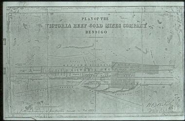 Bendigo Historical Society Inc.
Slide - ALBERT RICHARDSON COLLECTION: PLAN OF LEASES VICTORIA HILL
Slide. . Victoria Reef Gold Mines Company Mining Plan. Mount Korong Road on bottom of plan, Victoria Reef running through centre.mine, gold, victoria reef gold mines plan., bendigo mines-jack hattam collection -
Whitehorse Historical Society Inc.
Pamphlet, Nunawading 1999
Nunawading Council has produced a far reaching structure plan which plans to guide the community to the beginnings of the 21st century.Nunawading Council has produced a far reaching structure plan which plans to guide the community to the beginnings of the 21st century. This pamphlet seeks comments. Nunawading Council has produced a far reaching structure plan which plans to guide the community to the beginnings of the 21st century. local government, city of nunawading -
![M.M.B.W. reticulation plan no. 731, Shire of Blackburn and Mitcham. Locality plan of bores [1933].](/media/collectors/56f368632162f118acbff12e/items/60d923316e5f99545134f002/item-media/636db48a3e324a979b36a333/item-fit-380x285.jpg) Whitehorse Historical Society Inc.
Whitehorse Historical Society Inc.Document, Locality plan of bores, 1933
M.M.B.W. reticulation plan no. 731, Shire of Blackburn and Mitcham. Locality plan of bores [1933]. Scale 1' - 160'. Ref No. S 33/154.whitehorse road, blackburn, surrey road, clare street, francis street, pope road, queen street, albert street, chapel street, bores, melbourne and metropolitan board of works -
Port Melbourne Historical & Preservation Society
Plan - Tide limits at Inner East berth Station Pier for Tasmanian ferry Abel Tasman, Engineering Division, Port of Melbourne Authority, 1984
Plan: Tasmanian ferry at Inner East Station Pier - tide limits at working draft (lowest tide). This plan relates to the vessel Abel Tasmanabel tasman, piers and wharves - station pier, melbourne harbor trust - port of melbourne authority -
Clunes Museum
Drawing - Plans, J BARTRAM, CIRCA 1894
PLANS FOR THE ESTABLISHMENT OF CLUNES BUTTER FACTORY.1 2 PAGE LETTER, TYPED IN PURPLE INK .2 4 PAGES OF PAPER STAPLED TOGETHER WITH HAND HANDWRITTEN MATHEMATICAL CALCULATIONS OF THE QUANTITY OF SAWDUST OR CHARCOAL REQUIRED FOR REFRIGERATION CHAMBER .3 1 PAGE DRAWING OF THE MACHINERY ROOM AT CLUNES DISTRICT BUTTER FACTORY CO. LIMITED USING RED AND BLACK INK AND BLUE PENCIL .4 1 PAGE DRAWING OF SECTION THROUG A.B .5 1 PAGE OF WAX PAPER WITH HAND DRAWN PLAN OF BRICKWORK .6 4 PAGES OF BUFF COLOURED PAPER HANDWRITTENWITH MATHEMATICAL CALCULATIONS .7 1 PAGE OF DRAWING SECTION THROUGH A.C .8 1 PAGE OF BLUE COLOURED PAPER HANDWRITTEN WITH BLACK INK AND BLUE AND ORAGE PENCIL NOTATIONS.1 LETTERHEAD J. BARTRAM & SON 18 QUEEN STREET MELBOURN .3 MACHINERY ROOM AT CLUNES DISTRICT BUTTER FACTORY CO .LIMITED .5 SCALE: 1/1/2 INCH TO THE FOOT WRITTEN IN LEAD PENCIL .7 SCALE: 2FT TO 1 INCHj bartram & son, clunes & district butter factory co. limited, lordclyde creamery -
 Bayside Gallery - Bayside City Council Art & Heritage Collection
Map - print, Melbourne and Metropolitan Board of Works, Interim development order: Brighton, Moorabbin and Sandringham, 1959
The Melbourne and Metropolitan Board of Works (now Melbourne Water) was established in 1891. From that time, as part of their work laying water and sewerage connections, they created detailed plans of houses and other buildings in the Melbourne metropolitan area. In 1956 it acquired powers to construct and maintain highways and bridges, protect and improve the foreshores and create and maintain parks within the metropolitan region. This Interim development order comprises part of the municipalities of Brighton, Moorabbin and Sandringham and was made on 20 October 1959.brighton, moorabbin, sandringham, melbourne and metropolitan board of works, map, town planning, cartographic material, interim development order, bayside -
Bialik College
Mixed media (series) - Sites & Premises: fundraising appeals and plans for development
... planning ...1990s, 2000s, 1980s, buildings, development, planning, shakespeare grove, elc, 1970s1990s, 2000s, 1980s, buildings, development, planning, shakespeare grove, elc, 1970s -
Clunes Museum
Plan - CONCEPT DRAWINGS/PLANS, JOHN ALKEMADE & ASSOC, CLUNES COMMUNITY AND INTERPRETIVE CENTRE, 2012
CONCEPT DRAWINGS BY 3 ARCHITECTS AND EXPLANATORY INFORMATION. ALL LAMINATED ARCHITECT JOHN ALKEMADE & ASSOC. .1 PROPOSED FLOOR PLAN .2 SITE PLAN - PHOTOCOPY OF 1 AND 3 .3 SOUTH EAST VIEW ARCHITECT R. BRAMELL 2006 .4 LONGITUDINAL SECTION .5 FLOOR PLAN .6 FACADE ARCHITECT MORTON DUNN 2012 .7 GROUND FLOOR PLAN .8 SITE PLAN .9 FIRST FLOOR PLAN 10 CONCEPT DRAWING OF OUTCOME .11 WHAT IS THE CCIC .12 COMMUNITY REFERENCE GROUP .13 THE BUDGET .14 PROJECTED TIMELINE clunes community and interpretive centre concept, william barkell -
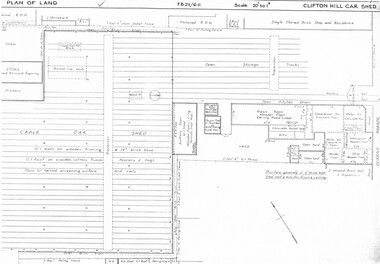 Melbourne Tram Museum
Drawing, Melbourne & Metropolitan Tramways Board (MMTB), "Clifton Hill car shed", c1937
Set of six photocopied plans or drawings on A3 sheet of Clifton Hill car shed - 3/1937 Some of the sheets overlap with each other. .1 - P? - Plan showing depot block, building plan and track plans .2 - P7689 - Plan of Land - dated 6-3-1937 .3 - P7690 - same as sheet one, but shows date and drawing number .4 - P? - part of shed with notes hand written on it - changes made to buildings - notes condensers and gas storage - possibly for the gas producer buses. .5 - part of plan with hand written notes .6 - dittotrams, tramways, drawings, depots, property, clifton hill cable tram depot, cable trams, world war 2, buses