Showing 1432 items matching "planning development"
-
 Port Melbourne Historical & Preservation Society
Book, Kate Shaw et al, Ewan Ogilvy's Bayside Papers, Box Three - Bayside Views - A Collection of critical perspectives on the Bayside Development, 1988
Ewan OGILVY, former Melbourne Councillor and also of Community Services Victoria, Inner Urban Ministerial Advisory Committee and Uniting Church's Centre for Urban Research and Action (CURA), was instrumental in social justice approaches to town planning. He and CURA's Social Justice and the City Project funded Port Melbourne community groups protesting against the SCDC development in 1987. His files were presented to the Society in May 2001 on his preparation for leaving Victoria.From Ewan OGILVY'S chronologically organised 'Bayside Papers' relating to the proposed development of Port Melbourne industrial land in the late 1980s: Bayside Views - A Collection of critical perspectives on the Bayside Development, a book of essays on Bayside issues, 1988 - funded by the Justice in the City projectSigned 'Ewan Ogilvy'town planning, town planning - proposals shelved - bayside, public action campaigns, environmental issues, public housing, missions to seamen, centre for urban research and action (cura), uniting church, sandridge city development co pty ltd, scdc, linton r lethlean, barry pullen, ewan ogilvy -
Surrey Hills Historical Society Collection
Work on paper - Vertical file, Development issues
(See also individual property files for development at specific addresses). 1. ‘Canterbury Road inequities’, SHNN, No. 9, April-May 1984. (1 page). 2. ‘Concern and indignation’, (re Lorne Parade Reserve), SHNN, No. 24, Oct.-Nov. 1986. (1 page). 3. ‘Overpass threat again?’, SHNN, No. 23, Aug.-Sept. 1986. (1 page). 4. ‘Premier urged to save Surrey Hills parkland’, (re Lorne Parade Reserve), Progress Press, 26.11.1986. (1 page). 5. ‘Shift Box Hill border to Union Rd, Mayor suggests’, SHNN, No. 21, April-May, 1986. (1 page). 6. ‘Libs’ heartland sends’, Progress Press, 16.12.1997. (1 page). 7. ‘SOS for councils to take controls’, Progress Press, 6.4.1998. (1 page). 8. ‘Where to next, for the Union Road centre?’, SHNN, No. 33, April-May 1988. (1 Page). 9. ‘Too much too soon, too little too late?’, and ‘Surrey Lodge, Better or worse?’, SHNN No. 41, Aug.-Sept. 1989. (1 page). 10. ‘Has Your Address Changed?’, SHNN, No. 99, April-May, 1999. (1 page). 11. ‘Maling Matters’, SHNN, No. 129, April-May, 2004. (1 page). 12. ‘Hard lessons in city’, Progress Leader, 22.12.2009. (1 page). 13. ‘Height of discontent’, Progress Leader, 27.7.2010. (1 page). 14. ‘Planning for our future’, Boroondara City Council brochure, October, 2013. (6 x A4 pages). 15. ‘Suburbs deluged by tasteless monoliths’, The Age, 14.1.2015. (1page). 16. Letterbox drop re petition against Liquorland, June, 2015. (2 x A4 pages). 17. Letter to the editor, by Murray A. Crow. SHNN, No. 195, April-May, 2015. (1 page). 18. Development in Surrey Hills, by Cliff Williams. SHNN, No. 195, April-May, 2015. (1 page). 19. ‘Angry message’, Progress Press, 16.12.1997. (1 page). -
 Bendigo Historical Society Inc.
Document - NEW CHUM & VICTORIA LINES OF REEF - NOTES ON VICTORIA HILL FOR TOURIST ATTRACTION
Handwritten notes outlining a plan for Victoria Hill, Central Nell Gwynne and New Chum Hill to be the focal position for a tourist attraction. Outlines steps to be taken to do the work and a mining museum at the Central Nell Gwynne. On the back of the page is a sketch of Victoria & New Chum Hills. On the plan is the Battery, Rae, Rae's House, Rae's Open Cut, Wittscheibe, Midway, Victoria Quartz, Lansell's 180 Shaft and the Recreation Reserve.document, gold, new chum & victoria lines of reef, central nell gwynne, new chum hill, bendigo and district tourist development association, victoria hill, lansell's big 180, victoria quartz, rae's open cut -
Port Melbourne Historical & Preservation Society
Document - Newsletter, Vol 3, SCDC, Sandridge News, 1987
Sandridge News vol. 3: a newsletter from the Sandridge Project, Sandridge City Development Companytown planning - proposals shelved - bayside, eileen mcbride, sandridge city development co pty ltd, scdc, robert peck -
Port Melbourne Historical & Preservation Society
Document - Newsletter, Vol 2, SCDC, Sandridge Construction Bulletin, 1992
Sandridge Consruction Bulletin vol 2, March 1992: a newsletter from the Sandridge Project, Sandridge City Development Company Also Vol 1 December town planning - proposals shelved - bayside, sandridge city development co pty ltd, scdc -
Port Melbourne Historical & Preservation Society
Document - Newsletter, Issue 1, City of Port Melbourne, Bulletin on Bayside, 1987 - 1991
Bayside Bulletin, a set of newsletters issued by the City of Port Melbourne to keep residents informed about the Bayside development: Issue 1 to 1991town planning - proposals shelved - bayside, local government - city of port melbourne, environmental issues, sandridge city development co pty ltd, scdc, evan walker, perce mcguire white, perce white -
Whitehorse Historical Society Inc.
Map, Yarran Dheran Landscaping, 1974
Charts relating to landscaping Yarran DheranCharts of various dimensionsnon-fictionCharts relating to landscaping Yarran Dheranyarran dheran, thompson paul, landscape planning -
 Lakes Entrance Historical Society
Photograph - Golf Houses residential development Golf Links Road Lakes Entrance Victoria, Lakes Post Newspaper, 1/12/1999 12:00:00 AM
Golf Houses residential development Golf Links Road Lakes Entrance Victoria - Proposed plan shown on notice boardColour photograph showing Matt Martino Bill Daniel Mike Hurst and Gary Jeal at the launch of Golf Houses residential development Golf Links Road Lakes Entrance Victoriatourism, land development -
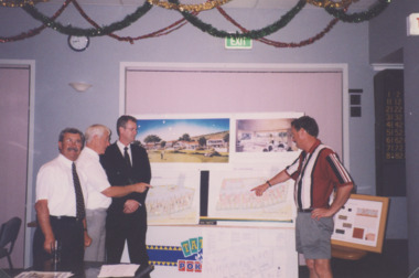
 Ringwood and District Historical Society
Map, Subdivision Plan of residential allotments on Canterbury Road, Bayswater (later surrounding Miller Road, Heathmont), Victoria - (Undated - circa 1930s)
Hand-drawn map on cardboard backing. Includes red pen notations marking allotments sold to Mrs A. Harrison, Mrs C Cornwall, J.M. Miller, and A.W. Dickson.Red pen notations mark allotments sold to Mrs A. Harrison, Mrs C Cornwall, J.M. Miller, and A.W. Dickson. Later subdivision of the map area took in Miller Road and Atunga Court developments. -
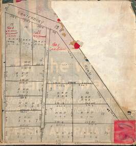
 Broadmeadows Historical Society & Museum
Photograph, Meeting under the Pergola to Chat, Banksia Gardens, 1998, 3 February 1998
"Meeting Under the Pergola to Chat" is part of the Banksia Gardens collection from 1998. It captures a moment of social interaction within a public space designed for residents of social housing to meet and engage with their neighbours. This image highlights the significance of communal areas in fostering a sense of community and belonging among residents. The pergola serves as a focal point for social gatherings, reflecting the thoughtful urban planning aimed at enhancing social cohesion and quality of life in the housing development during that period.The photograph titled "Meeting Under the Pergola to Chat" is part of the Banksia Gardens collection from 1998. It depicts social housing with public spaces designed for neighbours to meet and interact. This image captures the essence of community life and the importance of shared spaces in fostering social connections within the housing development. The photograph not only documents the architectural and social planning of the era but also highlights the value placed on communal areas for enhancing the quality of life for residents.Colour photograph on glossy photographic paper."Pergola where neighbours meet to chat, Public Housing"/"Banksia Gardens 1998"social housing, banksia gardens, pergola, meeting place, 1998 -
 Broadmeadows Historical Society & Museum
Photograph, Construction of Access Road, Banksia Gardens, c 1980s
... in the development of the Banksia Gardens housing project, highlighting ...This item depicts the construction of the Access Road to Banksia Gardens, The photograph captures a significant moment in the development of the Banksia Gardens housing project, highlighting the infrastructure improvements aimed at enhancing accessibility and connectivity within the community. The construction of the access road was a crucial step in the urban planning process, facilitating easier movement for residents and contributing to the overall development and integration of the housing estate.This item, showing the construction of the Access Road to Banksia Gardens, holds significant historical value. It documents a pivotal moment in the development of the Banksia Gardens housing project, illustrating the efforts to improve infrastructure and accessibility within the community. The construction of the access road was a key component in the urban planning strategy, aimed at enhancing connectivity and facilitating the movement of residents. This development not only improved the practical aspects of daily life for the community but also symbolised progress and growth within the housing estate. The photograph serves as an important record of the planning and development processes that shaped the Banksia Gardens community.Poor quality black and white photograph on matte photographic paper.banksia gardens, broadmeadows, construction, access road, c 1980's -
 Bendigo Military Museum
Photograph - Detachment - Army Survey Regiment, Bonegilla, Victoria, c1973
This is a set of six photographs of personnel from the Detachment - Army Survey Regiment taken in front of its main map production building at Bonegilla, Victoria in c1973. This cartographic map production sub-unit of the Army Survey Regiment operated in buildings owned by the School of Military Survey from 17th of June 1970 to the 30th of September 1985. A total of 800 topographic maps ranging in scale from 1:25,000 to 1: 250,000 scale were completed. A major focus of production in the 1970s was the cartographic completion of the Papua-New Guinea 1:100,000 map series and the Flexiflow quality control system was developed as a tool to coordinate production. The Flexiflow system comprised a series of job plans and charts linked to a task allocation to resource magnetic planning board. Using critical path analysis and task prioritisation, complex job planning was efficiently scheduled, and re-prioritisations readily made. Reproduction requirements were effectively coordinated by way of weekly courier to the Army Survey Regiment at Bendigo. Supervisors and technicians fully embraced the system as they could understand their role, others around them and the positive production achievements. WO1 Bill Boyd (who does not appear in this photograph) was the technical warrant officer for 11 years at the Detachment was awarded the OAM, the Order of Australia Medal for leading the development and the implementation of the Flexiflow system. By mid-1982, production of maps at these scales was undertaken digitally on Bendigo’s AUTOMAP 2 system and the Detachment reverted to production of small-scale large format RAAF aeronautical charts. Detachment personnel managed to produce 18 charts in the following two years, which was an impressive achievement for the staff, given major differences in format, specification and scales. Development of digital production of aeronautical charts in 1984-85 led to gradual reduction in production output and contracting out production was instigated to meet the shortfall and as a consequence the Detachment closed in September 1985. See pages 177 to 180 of Valerie Lovejoy’s book 'Mapmakers of Fortuna – A history of the Army Survey Regiment’ ISBN: 0-646-42120-4. for more information on the history of the Detachment at Bonegilla.This is a set of six photographs of the Detachment - Army Survey Regiment taken in front of the main map production building at Bonegilla, Victoria in c1973. The photographs were printed on photographic paper and are part of the Army Survey Regiment’s Collection. The photographic print and proofs were scanned at 600 dpi. .1) to .3) - Photo, black & white c1973. Back Row L to R: Peter Simpson, Chris Edwards, unidentified (x2), Colin Harden, Rowan Gillies, Bob Rowley OAM, Steve Hansen, Stu Thaxter. Centre Row L to R: Kevin Boehm, Dennis McCarthy, Peter Cross, unidentified, Brian Ryan, unidentified, Ian Marner, unidentified, Phil Smalley. Front Row L to R: Geoff Haynes, Bruce Wetzig, Dave Thompson, unidentified, OC Bob Roche, Ike Lever, John McCulloch, Dick Barwald, unidentified. .4) - Photo, black & white c1973. Back Row L to R: Peter Simpson, Chris Edwards, unidentified (x2), Colin Harden, Rowan Gillies, Bob Rowley OAM, Steve Hansen, Stu Thaxter. Centre Row L to R: Kevin Boehm, Dennis McCarthy, Peter Cross, unidentified, Brian Ryan, unidentified, Ian Marner, Phil Smalley, unidentified, Dick Barwald. Front Row L to R: Geoff Haynes, Bruce Wetzig, Dave Thompson, unidentified, OC Bob Roche, Ike Lever, John McCulloch, unidentified (x2). .5) - Photo, black & white c1973. Back Row L to R: Geoff Haynes, unidentified, John McCulloch, Bruce Wetzig. Front Row L to R: Dave Thompson, Ike Lever, unidentified. .6) - Photo, black & white c1973. L to R: OC Bob Roche, unidentified.There are no personnel annotated.royal australian survey corps, rasvy, army survey regiment, detachment - army survey regiment, army svy regt, asr -
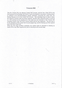
Port Melbourne Historical & Preservation Society
Plan - Proposed Beacon Cove Development plan by Sandridge City Development Company Pty Ltd, 17 July 1989
... Proposed Beacon Cove Development plan by Sandridge City... City Development Company Pty Ltd. Plan Proposed Beacon Cove ...A photocopy of a detailed of areas 1, 7 & 8 of the plan for Beacon Cove from the Sandridge City Development Company Pty Ltd.sandridge city development company pty ltd, local government - city of port melbourne, beacon cove -
Port Melbourne Historical & Preservation Society
Plan, Graeme Bentley Pty Ltd, Port Melbourne Foreshore Landscape Master Plan MP3 (A), February 1993
The Port Melbourne Foreshore Landscape Master Plan was created by Landscape Architectural firm of Graeme Bentley Pty Ltd for the City of Port Melbourne. MP3 (A) portrays the section of foreshore from Dow Street to Pickles Street. The plan proposed street tree planting along Beach Street and development of a park area opposite Johnson Street. The plan was not actioned.built environment - recreational facilities, beach street, port melbourne foreshore -
Port Melbourne Historical & Preservation Society
Plan - Proposed Beacon Cove Development plan by Sandridge City Development Company Pty Ltd, 17 July 1989
... Proposed Beacon Cove Development plan by Sandridge City.... Plan Proposed Beacon Cove Development plan by Sandridge City ...A photocopy of an Open Space Plan for Beacon Cove from the Sandridge City Development Company Pty Ltd.sandridge city development company pty ltd, local government - city of port melbourne -
Port Melbourne Historical & Preservation Society
Plan - Proposed Beacon Cove Development plan by Sandridge City Development Company Pty Ltd, 17 July 1989
... Proposed Beacon Cove Development plan by Sandridge City... the Sandridge City Development Company Pty Ltd. Plan Proposed Beacon ...A photocopy of a detailed of areas 3,4,11,12, 5c, 5b & 5c of the plan for Beacon Cove from the Sandridge City Development Company Pty Ltd.sandridge city development company pty ltd, local government - city of port melbourne, beacon cove -
Port Melbourne Historical & Preservation Society
Plan - Proposed Beacon Cove Development plan by Sandridge City Development Company Pty Ltd, 17 July 1989
... Proposed Beacon Cove Development plan by Sandridge City... the Sandridge City Development Company Pty Ltd. Plan Proposed Beacon ...A photocopy of a detailed of areas 2, 6, 9, 10, & 13 of the plan for Beacon Cove from the Sandridge City Development Company Pty Ltd.sandridge city development company pty ltd, local government - city of port melbourne, beacon cove -
Port Melbourne Historical & Preservation Society
Plan - Proposed Beacon Cove Development plan by Sandridge City Development Company Pty Ltd, 17 July 1989
... Proposed Beacon Cove Development plan by Sandridge City... City Development Company Pty Ltd. Plan Proposed Beacon Cove ...A photocopy of a detailed of areas 14 & 15 of the plan for Beacon Cove from the Sandridge City Development Company Pty Ltd.sandridge city development company pty ltd, local government - city of port melbourne, beacon cove -
Port Melbourne Historical & Preservation Society
Plan - Proposed Beacon Cove Development plan by Sandridge City Development Company Pty Ltd, 17 July 1989
... Proposed Beacon Cove Development plan by Sandridge City... City Development Company Pty Ltd. Plan Proposed Beacon Cove ...A photocopy of a detailed of areas 1, 7 & 8 of the plan for Beacon Cove from the Sandridge City Development Company Pty Ltd.sandridge city development company pty ltd, local government - city of port melbourne, beacon cove -
Port Melbourne Historical & Preservation Society
Plan - Proposed Beacon Cove Development plan by Sandridge City Development Company Pty Ltd, 17 July 1989
... Proposed Beacon Cove Development plan by Sandridge City... the Sandridge City Development Company Pty Ltd. Plan Proposed Beacon ...A photocopy of a detailed of areas 3,4,11,12, 5c, 5b & 5c of the plan for Beacon Cove from the Sandridge City Development Company Pty Ltd.sandridge city development company pty ltd, local government - city of port melbourne, beacon cove -
University of Melbourne, Burnley Campus Archives
Plan - Photocopy, Royal Park Landscape Development Plan, 1985
... Royal Park Landscape Development Plan... Existing Conditions Royal Park Landscape Development Plan Plan ...Photocopies of plans prepared for the City of Melbourne, November 1985 by Laceworks Landscape Collaborative Maunsell and Partners. (1) P & G DRG No 3/11 1 Longterm Parking Zoo. (2) P & G DRG No 3/12 0 Existing Conditionsroyal park, landscape, city of melbourne, zoological gardens, laceworks landscape collaborative maunsell and partners -
 Bacchus Marsh & District Historical Society
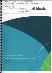
Booklet, Cultural Heritage Due Diligence Assessment Draft Report: Bald Hill Activation Project Final Report
... planning and development for a range of recreational uses. As part ...Bald Hill is a 120 hectare council reserve located in Darley, Bacchus Marsh. It overlooks the township of Bacchus Marsh and is one of the highest points in the township area. The reserve is undergoing ongoing planning and development for a range of recreational uses. As part of this planning a cultural heritage assessment was undertaken in 2019. This included assessment of the area for Aboriginal heritage. This assessment was part of the overall Bald Hill Activation Plan Final Report and forms an appendix to that report.Printed booklet. 39 pages. Spiral bound. Paper copy obtained from digital PDF document downloaded from Moorabool Shire Council website on 17 May, 2025. BMDHS Location: AR/SU5/Magazine Box 1Bald Hill is a 120 hectare council reserve located in Darley, Bacchus Marsh. It overlooks the township of Bacchus Marsh and is one of the highest points in the township area. The reserve is undergoing ongoing planning and development for a range of recreational uses. As part of this planning a cultural heritage assessment was undertaken in 2019. This included assessment of the area for Aboriginal heritage. This assessment was part of the overall Bald Hill Activation Plan Final Report and forms an appendix to that report. aboriginal australians bacchus marsh region history, aboriginal artifacts bacchus marsh region, heritage studies bacchus marsh victoria, bald hill bacchus marsh