Showing 10994 items matching " land"
-
 Bendigo Historical Society Inc.
Document - JUNE PARRY COLLECTION: MINING IN BENDIGO - LETTER TO MISS J. PARRY
Typed letter from W. M. Flentje to Miss J. Parry, Secretary, Bendigo Historical Society referring to the preservation of land to preserve mining relics. Part of the land may extend into private property and some crown Land. He says 'If the Land Conservation Council should decide to add the Crown land part of the area to the Forest Park, then preservation of the area will become our responsibility.' Letter written Forests Cmmission Victoria letterhead. It has a green logo on toe top of two trees, one eucalypt type and the other, a pine. Letter dated 10th December, 1976.document, memo, mining in bendigo, mining in bendigo, letter to miss j parry, forests commission victoria, whipstick forest park advisory committee, w m flentje -
Whitehorse Historical Society Inc.
Article, Cattle round-up recall, 2005
Grace Ferguson, who turned 100 recently, comes from one of the Blackburn area's pioneering families (Photo).Grace Ferguson, who turned 100 recently, comes from one of the Blackburn area's pioneering families (Photo). Her grandfather was George Augustus Goodwin, who donated land for St Johns Anglican Church and Blackburn Primary School. Reverse side: talking newspaper volunteer Lewis Roper (photo)Grace Ferguson, who turned 100 recently, comes from one of the Blackburn area's pioneering families (Photo). goodwin, george augustus, ferguson, grace, st johns anglican church, blackburn, blackburn primary school, no. 2923, talking newspaper, roper, lewis, mitcham repertory group -
 Bacchus Marsh & District Historical Society
Map, Main Road and Gell Street Allotments
This map shows allotments of land along Gell Street Bacchus Marsh running between Main Road (now called Main Street) and Lerderderg Street. The total area of the map encompasses Main Road, Church Street, Lerderderg Street and Gell Street. 36 allotments of land are shown. Three allotments which connect to Main Road are shaded in pink. The date of the map has not been established but the National Bank building erected in 1865 near the Border Inn is indicated which indicates that the map dates from after 1865. Reports in the Bacchus Marsh Express newspaper on 5 March 1870, page 2, column 6 announced building lots in Gell Street had been withdrawn from sale by the agent J.E. Crook. Later reports in the Express on 1 November 1873, page 2, column 2 advertised 14 allotments of land in Gell Street for sale. Single page map showing allotments of land along the Main Road (Main Street) and Gell Street areas of Bacchus Marsh. Part of a set of maps which are pasted into a bound volume containing 76 maps or plans in total. High resolution digital image stored on BMDHS computer network. bacchus marsh victoria maps, gell street land allotments, main street land allotments -
 Bendigo Historical Society Inc.
Document - H.A. & S.R. WILKINSON COLLECTION: CONTRACT OF SALE
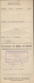
Contract of sale of land dated 11th October 1956 between Estate of J.N. Neilson deceased (seller) and Mrs. H.F. Redwood (buyer) for land being part of the Roman Catholic Church Reserve at Long Gully being land described in certificate of title volume 2653 folio 419, together with all buildings thereon also all linos, blinds and curtains in the dwelling. Price 1,600 pounds. Attached 3 pieces of paper with drawing in pencil of the land.organization, business, h.a. & s.r wilkinson real estate -
 Bendigo Historical Society Inc.
Document - H. A. & S. R. WILKINSON COLLECTION: CONTRACT OF SALE
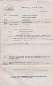
Contract of sale of land dated 10th December, 1952 between Mrs. A. Baggaley & Mr. A. Baggaley (vendor) and Mrs. A. M. Smyth (purchaser). Property: land delineated and coloured red on the map endorsed hereon part of allotment 23 section 3B Parish of Sandhurst City of Bendigo, land described in conveyance No. 619 book 495, together with all buildings thereon with a right of carriage way over the land coloured brown on the map. Price: 1,950 pounds.organization, business, h.a. & s.r wilkinson real estate -
 Kew Historical Society Inc
Photograph - Flooding of the Yarra Valley at Kew East, 1974
Flooding of the Yarra Valley, including that section of the Yarra bordering Kew and Kew East in the north and west of the municipality, was a regular occurrence. Extreme flood events of the Yarra River are recorded to have occurred in 1891, 1901, 1916, 1923 and 1934. The Municipality of Kew's response to these floods was to enact planning decisions restricting residential development in flood prone areas following the floods of 1916, 1921 and 1934. While floods continued after the development of the Upper Yarra Reservoir (construction 1948-57), the regularity and extent of these inundations diminished. During the nineteenth century, the land abutting the south side of the Yarra in Kew was devoted to dairy farming. In the twentieth century, before and after the construction of the Eastern Freeway, much of this low-lying area was used as golf courses and public parks.Late example of the capacity of the Yarra Valley at Kew to flood, even though drainage works and the Upper Yarra Reservoir had reduced their regularity.Original black and white print photograph of the low-lying land at East Kew under floodwater on 16 May 1974. The photograph is of Hyde Park looking north-east.Annotation verso: "Hyde Park looking nth-east / Flood Level / 16 May 1974 11.15am / R.L. 46.61"floods, yarra river, hyde park -
 Kew Historical Society Inc
Photograph - Flooding of the Yarra Valley at Kew, 1974
Flooding of the Yarra Valley, including that section of the Yarra bordering Kew and Kew East in the north and west of the municipality, was a regular occurrence. Extreme flood events of the Yarra River are recorded to have occurred in 1891, 1901, 1916, 1923 and 1934. The Municipality of Kew's response to these floods was to enact planning decisions restricting residential development in flood prone areas following the floods of 1916, 1921 and 1934. While floods continued after the development of the Upper Yarra Reservoir (construction 1948-57), the regularity and extent of these inundations diminished. During the nineteenth century, the land abutting the south side of the Yarra in Kew was devoted to dairy farming. In the twentieth century, before and after the construction of the Eastern Freeway, much of this low-lying area was used as golf courses and public parks.Late example of the capacity of the Yarra Valley at Kew to flood, even though drainage works and the Upper Yarra Reservoir had reduced their regularity.Original black and white print photograph of the low-lying land at East Kew under floodwater on 16 May 1974. The photograph is taken from 43 Kellett Grove.Annotation verso: "Kellett Gve No.43 / Flood Level / 16 May 1974 11.40am"floods, yarra river, kellett grove -
 Bendigo Historical Society Inc.
Document - H.A. & S.R. WILKINSON COLLECTION: CONTRACT OF SALE
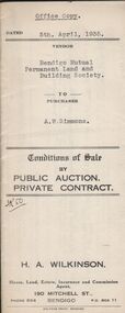
Conditions of sale by private contract dated 5th April, 1935 between Bendigo Mutual Permanent Land and Building Society (seller) and A.W. Simmons (buyer) for land being Crown allotment 7 section 104C and being the whole land described in certificate of title volume 2684 folio 536778. Price 450 pounds.organization, business, h.a. & s.r wilkinson real estate -
 Halls Gap & Grampians Historical Society
Photograph - B/W, C 1950s (?)
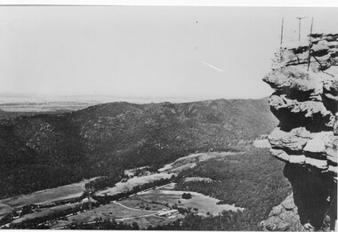
Photograph is of Fyans Valley taken from Bellfield Peak. The mountain range across the centre of the scene runs north to south. The large dwelling centre-front is Bellfield Hotel, which was destroyed by fire in the 1960s. The main road running through the middle of the valley is Grampians Road.A rocky outcrop, far right, with metal fence and posts. View of a valley with cleared land, roads and buildings in foreground. Further cleared land can be seen beyond a mountain range that is in the centre of the photograph.scenery, fyans valley -
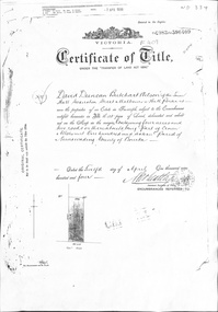 Whitehorse Historical Society Inc.
Certificate - Certificate of Title, Crown Allotment, 12/04/1904
Certificate of Title dated 12/4/1904 covering land in Shady Grove, Nunawading purchased by David Duncan Butchart Wilson. Crown Land Allotment No. 116 Parish of Nunawading County of Bourkeland titles, wilson, david duncan butchart, shady grove nunawading no. 76, higgins, mary, alcock, horace, holmes, dave, thumberstone, henry, helen -
 Phillip Island and District Historical Society Inc.
Documents, c1970
Documentation donated by Rob & Kathy Huddle, Glen Isla Motel, Church Street, Cowes Phillip IslandDocuments relating to the sale of land Lot 34, P/s 13650. Part C/A 6 in Ventnor. Includes Transfer of Land, Receipts for purchase, Rate Notice and Notice to Destroy Noxious Weeds.rose emma huddle, hilda joy king, rob & kathy huddle, ventnor land, glen isla, council rates, ventnor estate, noxious weeds -
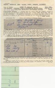
 Bendigo Historical Society Inc.
Administrative record - Application Register
The book original cover is dark green that has been wrapped in brown canvas to protect it. It has a leather spine with red and black labels. The pages in the volume are divided in columns: 1) Number of application, 2) Date of registry, 3) Date of application, 4) Surname, 5) Christian name and address, 6) Parish, 7) Allotment, 8) Section, 9) rea, 10) Local land board schedule, 11) Decision, 12) Special condition, 13) License, 14) References and remarks. The dates of the applications are from 30th August, 1874 to 26th April, 1876.On the front canvas cover: sec 173/174 3420. On the spine red label with gold letters: Application register. A black label with gold letters: all other sections land act 1901 (some of the letters are damaged)application register, land act 1901, 1874 to 1876 -
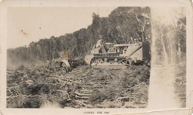 Phillip Island and District Historical Society Inc.
Photograph, 02/1941
One of a group of photographs from the Bryant West Collection donated by Mary Karney.Black & White photograph of a bulldozer clearing land in Cowes February 1941Cowes Feb 1941land clearing cowes phillip island, bulldozer, bryant west collection, mary karney -
Glenelg Shire Council Cultural Collection
Mixed media - DVD - History of land clearing in the Glenelg Shire, How the West was Won, 2010
DVD. How the West was Won, history of land clearing in the Glenelg Shire -
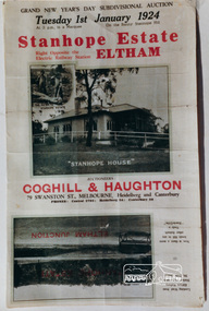 Eltham District Historical Society Inc
Photograph, Stanhope Estate Brochure, 1924
Photographs of extracts from Stanhope Estate land sales brochure, 1924.stanhope, land sales, estate agents, coghill, haughton, eltham -
Eltham District Historical Society Inc
Folder, Thomas Bell Darling, 1853
Folder of information on Thomas Bell Darling, land purchaser, Eltham, 1853thomas bell darling -
 Ringwood and District Historical Society
Photograph, At side of Ringwood State School looking along Greenwood Avenue, Ringwood, 1925
Taken from (or used in) Bestpart Estates Land Sales Brochure, 1925Written on back of photograph, "At side of Ringwood State School looking along Greenwood Avenue". -
Port Melbourne Historical & Preservation Society
Photograph - Aerial view of land reclamation at Webb Dock, Port Melbourne, 1997
Colour aerial photo showing land reclamatioon at Webb Dock, 1997piers and wharves - webb dock, melbourne harbor trust - port of melbourne authority -
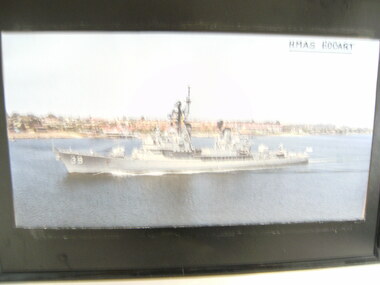 National Vietnam Veterans Museum (NVVM)
Print, HMAS Hobart
Black plastic framed coloured print of HMAS Hobart passing landprint, hmas hobart -
 Uniting Church Archives - Synod of Victoria
Photograph, 1939
The Corryong Methodist Church opened in 1939 by Rev. T.C. Rentoul, the Superintendent of Home Missions.B & W photograph of fenced land surrounding the Corryong Methodist Church.corryong methodist church, rev. t.c. rentoul, superintendent of home missions -
University of Melbourne, Burnley Campus Archives
Booklet - Prospectus, Graduate Prospectus, 2013
University of Melbourne School of Land & Environment Graduate Prospectus. 39 pp.university of melbourne, school of land and environment, graduates -
 Hume City Civic Collection
Photograph
A coloured photograph of the grassland and scrub land which is situated north of Rupertswood.grassland, rupertswood estate, george evans collection -
Clunes Museum
Certificate - MORTGAGE-CERTIFICATE, 4TH MAY 1880
MORTGAGE HELD BY MR. JOHN SWAINSON FOR LAND IN HILL STREET, CLUNES.local history, document, mortgage, swainson family -
Whitehorse Historical Society Inc.
Document, East Burwood reserve, 1992
History and map of East Burwood Reserve - includes details of acquisition of landHistory and map of East Burwood Reserve - includes details of acquisition of landHistory and map of East Burwood Reserve - includes details of acquisition of landcity of nunawading, east burwood reserve, burwood highway, burwood east, nos 292 - 336 -
 Whitehorse Historical Society Inc.
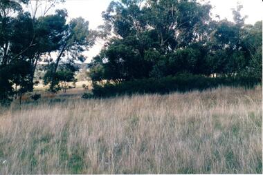
Document, 5 Select Homes Sites Mitcham, 16/11/1929 12:00:00 AM
Auction of land in Mitcham.Auction of land in Mitcham. Includes schetch map of locations and names of purchasersAuction of land in Mitcham. auction, station front estate, mitcham road, mcdowell street, doncaster east road, whitehorse road, coghill & haughton estate agents, drake & co estate agents, roeszler, norman george, edith mary, reid harrison street -
 Whitehorse Historical Society Inc.
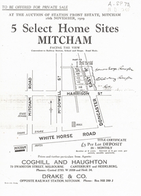
Document, Kings Padddock Blackburn
Plan showing land for sale at Kings PaddockPlan showing land for sale at Kings Paddock, Blackburn (second section).Plan showing land for sale at Kings Paddockauctions, kings paddock, blackburn, south parade, laburnum street, the avenue, fuchsia street, laurel grove, main street, t.r.b. morton & son -
 Whitehorse Historical Society Inc.
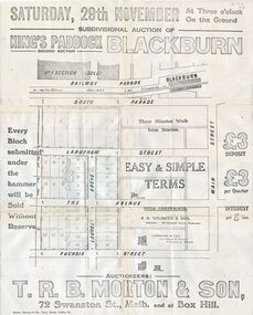
Document, Sylvan Glades Paddock Blackburn, C1922
Brochure advertising land salesBrochure advertising land sales on corner of Blackburn Road and The Avenue, Blackburn.Brochure advertising land sales land subdivision, sylvan glades paddock blackburn, t. r. b. morton & son, orchid street, blackburn, heath street -
Whitehorse Historical Society Inc.
Article, Wurundjeri Walk, 1988
Freeway land: Council may pay $3.3 million by Wendy Woods,Freeway land: Council may pay $3.3 million by Wendy Woods,Freeway land: Council may pay $3.3 million by Wendy Woods,healesville freeway reservation, fulton road, blackburn south, woods, wendy, roads and streets -
 Ballarat Heritage Services
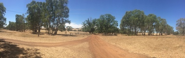
Photograph, Clare Gervasoni, Entrance to Merino Downs, Henty, 2015, 22/12/2015
Merino Downs was the property of early squatters the Henty brothers. Pentonvillian Exile George Ind worked for the Henty's at Merino Downs after his arrival at Portland in 1845. The Henty daughters were witnesses to his marriage. Colour panoramic photograph of land around Merino Downs, Henty, Victoriahenty, merino downs, henty brothers, george ind, henty daughters, panorama -
 Bendigo Historical Society Inc.
Document - Victoria the Land Act 1890 and the Wattle Act 1891, 1888-1892
Victoria the Land Act 1890 and the Wattle Act 1891 283 pages. Inside the front cover which has been removed the page has been filled with an indecipherable hand written memo..history, bendigo, mining, victorian land act