Showing 11005 items matching " plan"
-
 Old Colonists' Association of Ballarat Inc.
Book - Conservation Management Plan, David Rowe, Authentic Heritage Services Pty Ltd et al, Old Colonists' Hall Conservation Management Plan, 10/March 2021
A comprehensive analysis of the Old Colonists' Hall at 20 Lydiard Street North, Ballarat Centralold colonists' hall, lydiard street north, ballarat, ballarat old colonists' club, ballarat old colonists' association, philnthropy, sopkeepers, old colonists' and pioneers associaitons, shop keepers, shpokeepers, conservation and actions, old identities' associaiton, australia icomos burra charter, government camp ballarat -
Tramways/East Melbourne RSL Sub Branch - RSL Victoria Listing id: 27511
Book, B.H. Liddell Hart, THE ROMMEL PAPERS(Rommel's plan for the attack on Tobruk), 1953
-
 Department of Health and Human Services
Photograph, Architectural drawing, provided by the Department of Public Works, of an autopsy table for Ballarat Mental Hospital. The plan is dated 09/01/1959 - Regional & District Hospital Collection - Department of Health & Human Services (DHHS)
Photo is part of the Department of Health, Building & Services Division, Facilities Development - Hospitals - Photographic Inventory -
Moorabbin Air Museum
Manual (Item) - RAAF - Winjeel Aircraft A85F Technical Maintenance Plan
AAP 7212.003-7 -
Moorabbin Air Museum
Book - FLIGHT PLAN PNG, EILEEN STEENSON, 1974
-
Moorabbin Air Museum
Letter (Item) - Ansett Cash Deposit Plan
-
Moorabbin Air Museum
Booklet (Item) - Ansett Transport Industries Airline Ground Staff Superannuation Plan No.2
-
Moorabbin Air Museum
Book (Item) - Ansett Great Business Plan
-
Moorabbin Air Museum
Manual (Item) - Hawk 200 Project Air 5044 procedures & definition & Development cost plan [possibly Hawk 200 contender]
-
 Ballarat Tramway Museum
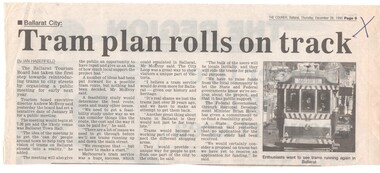
Newspaper, The Courier Ballarat, "Tram Plan rolls on track", 28/12/1995 12:00:00 AM
Article from page 9 of The Courier, Thursday 28/12/1995 written by Ian Haberfield that a tentative date had been set for Jan. 23, 1996 for a public meeting to discuss the return of trams to Ballarat. Quotes Tourism Board Executive Director Andrew McEvoy. Includes a picture of tram 40, with destination of Sebastopol."X" in blue ink in top right hand cornertrams, tramways, public meeting, ballarat city tramway, ballarat revival -
 Ballarat Tramway Museum
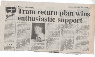
Newspaper, The Courier Ballarat, "Tram return plan wins enthusiastic support", 24/01/1996 12:00:00 AM
Article from page 3 of The Courier, Wednesday 24/1/1996 written by Ian Haberfield reporting on the public meeting held the previous night at the Town Hall Ballarat. Quotes Peter Hiscock, Richard Gilbert, Jenny Beacham (Labor Candidate for Ballarat), Paul Jenkins, Vern Robson.trams, tramways, public meeting, ballarat city tramway, ballarat revival -
 Ballarat Tramway Museum
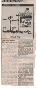
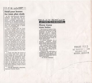
Newspaper, The Courier Ballarat, "Hold your horses for tram plan study", 3/02/1996 12:00:00 AM
Letter to the Editor of The Courier, Saturday 3/2/1996 written by Peter Hiscock, Chairman Ballarat Tourism Board replying to D.H. Woodward's (notes as former councillor) letter of 31/1/1996 (item 1468), commenting that the study should be done before knocking the project. Notes that the questions are valid, but the study should be done. Notes that Mr. Woodward has opposed many heritage projects. Also has a Burns cartoon about cable TV."Sat 3/2/96" in blue ink on top edge.trams, tramways, letter to the editor, ballarat city tramway, ballarat revival -
 Ballarat Tramway Museum
Document - Photocopy, Frank Puls, "Hold your horses for tram plan study", "Horse Trams even better", Feb. 1996
Photo copy of two letters to the Editor of The Courier on a single sheet of paper, collected by Frank Puls. Has Frank's address stamp on the right hand edge. 1. Saturday 3/2/1996 written by Peter Hiscock, Chairman Ballarat Tourism Board replying to D.H. Woodward's (notes as former councillor) letter of 31/1/1996 (item 1468), commenting that the study should be done before knocking the project. Notes that the questions are valid, but the study should be done. Notes that Mr. Woodward has opposed many heritage projects. See also Reg. item 1469 for original of the cutting. 2. Monday 5/2/1996 written by E.Calis of Ballarat, suggest that horse trams should be considered, or a horse and wagon. Both cuttings have handwritten date and newspaper name on the top.trams, tramways, letter to the editor, ballarat city tramway, ballarat revival -
Ballarat Tramway Museum
Newspaper, Elise Sullivan, "Govt help for our tram plan", 4/01/1997 12:00:00 AM
Front page of The Courier, Ballarat Saturday 4/1/1997 written by Elise Sullivan about the announcement the previous day that the Federal Government announced a grant of $20,000 for a feasibility study into the return of trams to Ballarat. Grant announced by Ballarat MHR, Michael Ronaldson. Also quotes Ballarat Tourism Board Executive Director Andrew McEvoy that the news of the grant was "fantastic". Item continues onto the top right hand corner of page 2. Mr. McEvoy said that further money was required for the study. Also includes a small photo of Andrew McEvoy.feasibility study, ballarat city tramway, ballarat revival -
Moorabbin Air Museum
Booklet (Item) - Sydney Flight Plan - community forum
-
Moorabbin Air Museum
Document (Item) - GAF ASTA Nomad Training Plan
-
Moorabbin Air Museum
Manual (Item) - Government Aircraft FactoriesA-10 Wamira Project, Government Aircraft Factories Tooling Estimates GAF Project RAAF Basic Pilot Training Aircraft Project Phase 3- Production Investment Plan
Government Aircraft Factories -
Ballarat Tramway Museum
Film - Video cassette tape and box, Ballarat Nine News Network and Alan Snowball, "Ballarat City Tramway Plan", 11/07/2002 12:00:00 AM
VHS cassette and cardboard box, black plastic, with white insert cover, and labels on cassette and VHS video tape. Contains recording of the Ballarat Nine Network news service of 11/7/2002 reporting on the previous nights Ballarat Council Meeting receiving the report on the Ballarat City Tramway proposal. 00.00 to 15.50 - general items from previous shows 1550 - 1620 - News headlines and notes at 1620, headline regarding the Ballarat City tramway and short video clip of a tram. 1620 - 2410 - news, bomb hoaxes, Johns Valves industrial problems etc. 2410 - 2535 - report on Ballarat Council meeting the previous nights, interviews with the Mayor David Vendy, Austin Brehaut and Alan Snowball. Mentions BTM and operation at Lake Wendouree. 2535 - onwards - report on the Stoddart Statue collection at the gardensOn box and tape label, notes re tape size and AS (Alan Snowball) number.btm, city tramway, video tape, news broadcasts -
 Ballarat Tramway Museum
Document - Photocopies, Alan Bradley, "Purchase of horse car plan from the MTT Adelaide", 1980's
Has a strong association with event following the Sebastopol horse tram depot fire of 1909, where ESCo obtained further horse trams from the Adelaide trams. Copies of letters.Photocopies of a set of copy letters from the State Records of South Australia, Reference GRG 22/31/Vol. D. Copy of letters between Benjamin Deakin, Engineer and Manger ESCo and the Chief Engineer and General Manager of the Adelaide Metropolitan Tramways Trust regarding the purchase of horse trams harness and other equipment following the Sebastopol depot fire. Correspondence dated Oct. 1909. Has a header sheet - see image file.trams, tramways, horse trams, adelaide, sebastopol, fire, esco -
 Ballarat Tramway Museum
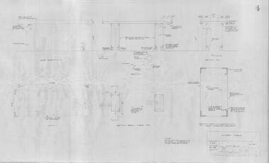
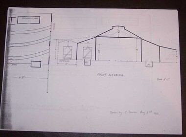
Document - Photocopy, Alan Bradley, "Plan and Front Elevation of Car Depot", 2000
Set of three A3 size photocopies of a drawing held by the Public Records Office Victoria of the Ballarat ESCo Tramway Depot, dated 2/8/1912. Drawn at a scale of 1/16" = 1', shows building layout, track layout, overall dimensions, a proposed extension to hold eleven trailers, a front elevation showing pits, extension (drawn at 1/8" = 1'). On the current tracks, shows the individual track capacities - 26 trams. Drawings copied by Alan Bradley for archives and research.trams, tramways, ballarat, esco, depot, drawings -
Moorabbin Air Museum
Manual (Item) - RAAF - Technical Maintenance Plan Dakota Aircraft A65B
AAP 7211.006-7-1 (Issue 4) -
Moorabbin Air Museum
Manual (Item) - Douglas DC-3/C-47 Dakota Amendment lists, Technical Maintenance Plan Dakota Aircraft Amendment List
-
Moorabbin Air Museum
Manual (Item) - Douglas DC-3/C-47 Maintenance Plan, Technical Maintenance Plan Dakota Aircraft A65B
Sealed in clear plastic -
Moorabbin Air Museum
Manual (Item) - Douglas DC-3/C-47 Maintenance Plan, Technical Maintenance Plan Dakota Aircraft (TMP Code 065)
-
Moorabbin Air Museum
Document (Item) - P.A.T.S. Boeing 767 Simulator 2B Flight Plan ETOPS Ansett Australia
-
Moorabbin Air Museum
Manual (item) - CAC Production of Turbine and Compressor Blades, Development Plan Production of Compressor & Turbine Blades at CAC
CAC Collection -
Moorabbin Air Museum
Document (item) - CAC Collection - Restructure Planning Master Plan Issue 2
-
Moorabbin Air Museum
Document (item) - CAC Collection - CAC Five Year Plan 1977-1981
-
Moorabbin Air Museum
Document (Item) - F/A-18 Program Maintenance Plan, Maintenance Plan
-
 Queen Victoria Women's Centre
Booklet, Queen Victoria Woman's Centre Strategic Plan 2014-2018, c.2013
A3 page foleded to create a four page booklet. Purple and yellow accent colours used. pamphlet, cultural structures and establishments