Showing 12766 items
matching reserves
-
 Melbourne Tram Museum
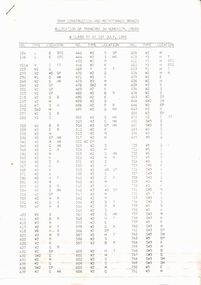
Administrative record - Depot List, The Met, "Tram Construction and Maintenance Branch - Allocation of Tramcars 1.7.1985", Jul. 1985
Depot List - 13 A4 sheets, were stapled in top left hand corner, titled "Tram Construction and Maintenance Branch - Allocation of Tramcars 1.7.1985" Sheets 1 to 6 - Allocation of Tramcars in Numerical Order including listing of tramcars for storage and disposal and storage and retention in operating condition to A 254. Sheets 7 to 12 - allocation by depot including trams in storage at Hawthorn, Approved disposal, future disposal, training tram, tourist trams and special purpose, Ministry of Arts, Decorated trams, Reserve trams. Sheet 13 - Summary of Fleet in Service.trams, tramways, tramcars, mmtb, lists, depots, depot allocation -
 Melbourne Tram Museum
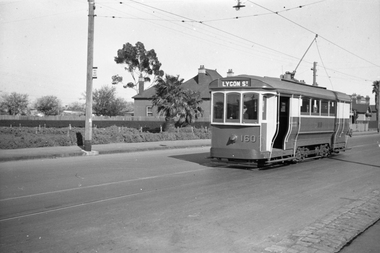
Negative, Wal Jack, 1/09/1941 12:00:00 AM
Black and white negative, by Wal Jack, of S160, east bound in Holden St passing the Holden St Reserve on the corner of Byrne St. The Lygon St destination is shown, which is not correct. Note the bus stop sign on the adjacent pole. Tram is fitted with a headlight mask. It is thought that one end of the tram generally would show St Georges Road and the other Lygon St. Possibly mixed up. Also see other photos of the tram on the same date. Photo dated 1-9-1941 in the Wal Jack album along with details of the location.trams, tramways, holden st, s class, headlight mask, tram 160 -
 Bendigo Military Museum
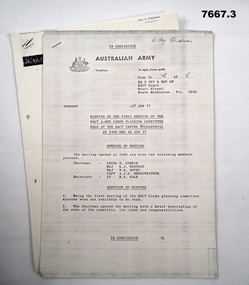
Document - DOCUMENTS - MISCELLANEOUS - ARMY, Australian Army
1. Minutes of the first meeting of the RACT A-RES Corps Planning Committee held at the RACT Centre, Puckapunyal at 1400 hrs 26 Jun 1977. 2. Provision of self drive vehicles, Army Reserve Staff. 3. Physical Training tests (PTT) ARES. Part of the "Kevin John Herdman" No. 397661 Collection. See Cat 5942P for details of his service. Three Australian Army photocopied documents on A4 paper. Each document's pages are stapled on top LHC. Text in black type. Australian Army letterhead on top of first page of each document. Printing on one side of each page.1. Handwritten in blue ink on page 1: "Maj Herdman". 3. Handwritten in blue ink on page 1: "MAJ K. HERDMAN"ract, vehicles, army, physical training, kevin john herdman -
 Warrnambool and District Historical Society Inc.
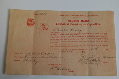
Document - Charles Geary Collection, 1915-1922
This collection of six documents (1915-1922) belonged to Charles Geary who was born in Warrnambool, the son of Thomas and Martha Ellen Geary in 1893. The collection documents his joining the Australian Imperial Expeditionary Force A.A.M.C. Dental Reserve, his subsequent discharge and post military employment in the Town of Warrnambool as a Hackney Carriage Driver and later as a second class engine driver.. This collection gives examples of references and certificates of leave required to join the A.I.F. in 1916. The discharge certificate is a good example of what was given to military personnel after their services were no longer required. The llicense and certificate of competency show some of Charles' post war endeavours. Charles is listed on the Warrnambool Fire Brigade World War 1 Honour Roll as an active member. (.1) Typewritten refence on Robinson's Motor Pty. Ltd. green and navy printed letterhead with a purple ink stamp and black written signature and embossed company seal. (.2) Reference, handwritten in black ink on blue 8mm lined white paper with a 38mm printed margin. (.3) Black print on a cream certificate completed in black ink. (.4) Cotton woven paper certificate completed in blue, black and red ink with black ink thumb prints. (.5) Black printed Certificate number 1069 on cream paper completed in black ink. (.6) Peach coloured certificate with red printing on heavy weight paper completed in black ink and numbered 8313charles geary, australian army medical corps dental reserve, a.a.m.c., robinson's motor proprietary limited, geo powell, country fire brigades board of victoria, hackney carriage driver's license, second class engine driver, dental mechanic -
 Greensborough Historical Society
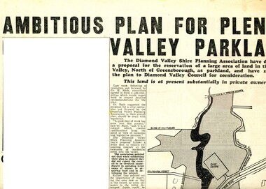
Newspaper Clipping - Digital Image, Ambitious plan for Plenty Valley Parklands 1965, 05/11/1965
In 1965, the Diamond Valley Shire planning association recommended to Council that a large area of land north of Greensborough be acquired for Parkland. The idea of a Civic Centre was included with a map of the area from Grimshaw Street in the south to the MMBW pipeline reserve in the north. Includes a suggested new site for the local school, near Yando Street. This area is now part of the Plenty River Trail.An example of developments in the Greensborough area during the period of Shire of Diamond ValleyNews clipping, black and white text and map. Scanned in 3 parts.shire of diamond valley, civic drive greensborough, yando street greensborough, partingtons flat, plenty river trail -
 Greensborough Historical Society
Map, Heidelberg: Historic River Landscape Assessment. Historical maps. Map E 1901-1934 "A Time of projects and improvements", 1985c
Geographical area of around 35 sq. kilometres marked with physical features such as major roads, railways (new extension to Eltham), rivers and properties, also housing sub-divisions and community facilities such as hospitals, parks and sporting reserves and indications of new small scale industries such as dairying. Bounded by Shire of Diamond Valley to the North, Darebin Creek to the West and Plenty River to the East. Black and white sketch map on white paperheidelberg, heidelberg - maps -
 Greensborough Historical Society
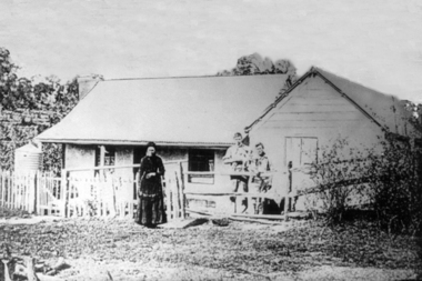
Photograph - Digital image, Mary Poulter, 1888c
Mary Poulter and sons in Greensborough. The boys could be William (b1865) and Arthur (b1867). Mary appears to be in mourning, her husband William died in 1888. William Poulter and his wife Mary arrived in Victoria in 1849 and settled in Greensborough in 1853. Descendants of the family still live in the area. The house was known as Bonnie Vale and located roughly in the middle of what is now Poulter Reserve.Greensborough pioneer family Digital copy of black and white photograph.mary poulter, poulter family, bonnie vale, poulter reserve -
 Glen Eira Historical Society
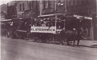
Photograph - ELSTERNWICK
This file contains 15 items: 1/5 Photocopied photographs of early Elsternwick buildings and railway reserve c. 1901. 2/2 Photocopied photos and one original photo of local transport in Elsternwick c. 1908, and one print of Nettie Palmer on a bicycle in Elsternwick in 1902. 3/7 coloured photographs of painted signage on buildings in Elsternwick uncovered in 1989.elsternwick, forests, timber, elsternwick post office, elsternwick railway reserve, hampton albert g., motorcars, motorvehicle repair shops, taxis, beavis street, davenport ron, carre street, wagons, johnson mr., grocers, signs, higgins james, tarrier, blacksmith, palmer nettie, bicycles -
 Ballarat Heritage Services
Document - Report, McDougall and Vines Conservation and Heritage Consultants, Sturt Street Gardens, Ballarat, Victoria Conservation and Landscape Management Plan, 2007, 07/2007
Ballarat's Sturt Street has its origins in W.S. Urquhart's survey of 1851. A generous reserve was allocated for the main streets of Ballarat, of which Sturt Street was the first. In the 1860s Sturt Street was planted with blue gums, with a dual carriageway and central median strip installed. Bandstands ere soone erected, including the Queen Alexandra Bandstand (1908) and the Titanic Memoria Bandsatnd (1915).PDF of a report on the Sturt Street Gardens, Ballarat.sturt street ballarat, conservation management plan, sturt street gardens, landscape management plan, statue, gardens, bandstands, infrastructure, city of ballarat report -
 Kew Historical Society Inc
Photograph - Kew Junction, Herald & Weekly Times, 1962
This is an aerial oblique image looking north. It shows Kew Junction before construction of VicRoads (Country Roads Board), Murphy's (Leo's) supermarket, and office towers. It also shows a building on the land now known as the Raoul Wallenberg Reserve, the Kew Municipal Offices in Walpole Street, and St Paul's School for the Blind in Fernhurst Grove, and Kew Bowling Club in Wellington Street.An aerial photograph of Kew Junction, showing the intersection of High Street South, Studley Park Road, Princess Street, High Street and Denmark Street. A number of buildings, now demolished can be identified in the photo, including Jellis’ Bakeries on the corner of Princess Street and Studley Park Road." Annotation on reverse: "Kew Historical Society from Mr L. H. Chinner".kew junction, aerial photograph (kew), oblique aerial, st paul's school for the blind, kew municipal offices, high street kew, studley park road, kew war memorial, kew post office, kew police station, kew court house, high street south, kew, wellington street kew, denmark street kew -
 8th/13th Victorian Mounted Rifles Regimental Collection
Photograph
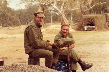
A cadre staff of regular soldiers was posted to Army Reserve units to assist with training and administration. While many recruits could already drive when they joined 8/13 Victorian Mounted Rifles it took many hours of instruction and training before they were licenced to drive heavier, more complex army vehicles both on and off road and under combat conditions.Colour photograph of two members of Cadre Staff of ' A ' Squadron 8/13 Victorian Mounted Rifles during a driver training exercise 1986. camouflaged vrhicle in background." Corporal Potts, WO " Burnie " -
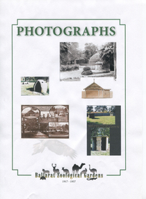 Friends of Ballarat Botanical Gardens History Group
Work on paper - "The Little Zoo in the Gardens" booklet, Ballarat Zoological Gardens, 2017
"The Little Zoo in the Gardens" booklet. Henry Ben Jahn was the benefactor behind the establishment of the Ballarat Zoological Gardens. He died 28 December, 1911 and the zoo was opened on 17 April, 1917 and closed 1957. In 1995 the residue of Henry Ben Jahn's estate was used to help fund the re-establishment of a wetlands in the North Gardens Reserve, now known as the North Gardens Wetlands."The Little Zoo" at the Northern end of the Ballarat Botanical Gardens was an example of how the acclimatisation societies across the British Empire tried to establish familiar animals into new environments.Coloured images on white paperNone.john garner collection, garner, dr, zoo, ballarat zoological gardens, ballarat botanical gardens, gardens, ballarat, henry ben jahn, benefactor, north gardens wetlands, the little zoo. -
 Bendigo Historical Society Inc.
Document - PETER ELLIS COLLECTION: A GUIDE FOR DRIVERS ON THE WHIPSTICK TOUR
A Guide for Drivers on the Whipstick Tour. First page gives assembly area, driving in convoy and negotiating water or boggy patches across the road. Amended written at the end of the page. Directions with mileage and items of interest for the tour on Sunday September 9th (no year). A Whipstick Map 1971 showing State Forest, Crown Lands, Uncleared Mallee - Private (shown in different colours) Water Reserve and Roads. Noted are Flora and Fauna - Plants, Birds & Mammals, and areas of State Forest and Southern State Forest with Mallee Scrub area noted. Also State Forest & Crown Lands Total Area and a map scale. The Bendigo Whipstick mentions area, suggestions of where the name Whipstick came from, shrubs and flowers with their flowering times, descriptions of some of them and some information on the Mallee Fowl. The Eucalyptus Oil Industry paragraph mentions the beginnings of the industry. Mentioned are the different uses of oils (perfumery, industrial and medicinal) and the different species of eucalypt used for each and various products. Also notes on the growing, harvesting and refining of eucalyptus. P Ellis at the end of the page. The next two and a half pages mentions reserves, and at the end acknowledgements. Includes a spare copy of 'The Bendigo Whipstick' by P Ellis.bendigo, history, early bendigo, peter ellis collection, a guide for drivers on the whipstick tour, the whipstick 1971 map, shire of marong, shire of east loddon, shire of huntly, borough of eaglehawk, city of bendigo, shire of strathfieldsaye, the bendigo whipstick, eucalyptus oil industry, eaglehawk town hall, lightning hill lookout, eaglehawk rifle range, new moon mines, blue jacket reservoir, maggetti's wine hall, camp hotel (ex), skylark dam, eucalyptus oil production, eucalyptus factory, whipstick eucalyptus farm, ruedin's eucalyptus factory, dutch bowls, governor philip, sir joseph banks, john white, baron von mueller, joseph bosisto, commonwealth government, perfumery oils, industrial oils, medicinal oils, p ellis, dr frith, csiro wildlife division, harley webster, forests commission, vincent serventy, victorian national parks association, bendigo field naturalists club -
 Eltham District Historical Society Inc
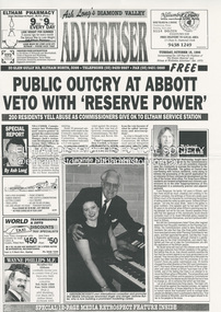
Document - News Clipping, Advertiser, Public Outcry at Abbott Veto with 'Reserve Power; 200 residents yell abuse as commissioners give ok to Eltham service station; Advertiser, Tuesday, October 15, p1, 1996
Nillumbik Commissioners used 'reserve power's to permit a controversial Shell service station and Hungry Jackls restaurant development at the former Eltham Shire Office site at 895 Main Road. More than 200 people attended the Council meeting in the public gallery and protested at the decision. 32 personal submissions were made to Council's Planning Special Committee meeting whose members vioted 3-2 against the development. The Committee consisted of the three Nillumbik Commissioners and three community members (Jim Connor, Bronwyn South and Janet Mattiske). Chief Commissioner Don Cordell, a former Shell employee excused himself from voting and the three communbity memebrs voted against the submission. The other two commissioners, Vin Heffernan and Kevin Abbott voted against it. They then immediately closed the meeting and opened a Council meeting lasting just seconds to use special reserve powers to overturn the decision. The demolition of the former Shire of Eltham offices and proposed sale and development driven by the Commissioners for Nillumbik Shire Council brought the community together in substantial protest at the infrigement of ratepayers democratic say in local government and ciommunity assets combined with protests about inappropraite development of Eltham's Gateway. This issue led to the formation of the Eltham Community Action Group which still operates strongly today (2023) on behalf of the community to ensure appropriate development within the community.895 main road, commissioners, dallas price homes, development application, eltham hub, hungry jacks, nillumbik shire council, re-zoning, shell service station, town planning, eltham gateway, eltham gateway action group, eltham shire offices, shillinglaw farm, shillinglaw trees, jim connor collection, dallas howgate, frank burgoyne, robert marshall, nillumbik planning special committee, jim connor, bronwyn south, janet mattiske, don cordell, vin heffernan, kevin abbott -
 Eltham District Historical Society Inc
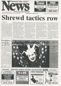
Document - News Clipping, Jodie Guest, Shrewd tactics row, Diamond Valley News, October 15, p1, 1996
Nillumbik Commissioners used 'reserve power's to permit a controversial Shell service station and Hungry Jackls restaurant development at the former Eltham Shire Office site at 895 Main Road. More than 200 people attended the Council meeting in the public gallery and protested at the decision. 32 personal submissions were made to Council's Planning Special Committee meeting whose members vioted 3-2 against the development. The Committee consisted of the three Nillumbik Commissioners and three community members (Jim Connor, Bronwyn South and Janet Mattiske). Chief Commissioner Don Cordell, a former Shell employee excused himself from voting and the three communbity memebrs voted against the submission. The other two commissioners, Vin Heffernan and Kevin Abbott voted against it. They then immediately closed the meeting and opened a Council meeting lasting just seconds to use special reserve powers to overturn the decision. The demolition of the former Shire of Eltham offices and proposed sale and development driven by the Commissioners for Nillumbik Shire Council brought the community together in substantial protest at the infrigement of ratepayers democratic say in local government and ciommunity assets combined with protests about inappropraite development of Eltham's Gateway. This issue led to the formation of the Eltham Community Action Group which still operates strongly today (2023) on behalf of the community to ensure appropriate development within the community.895 main road, commissioners, dallas price homes, development application, eltham hub, hungry jacks, nillumbik shire council, re-zoning, shell service station, town planning, eltham gateway, eltham gateway action group, eltham shire offices, shillinglaw farm, shillinglaw trees, jim connor collection, dallas howgate, nillumbik planning special committee, jim connor, bronwyn south, janet mattiske, don cordell, vin heffernan, kevin abbott -
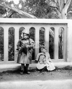 Eltham District Historical Society Inc
Photograph, Grace Mitchell, A young Jenni Mitchell with flowers and teddy bear on Main Road Bridge, Eltham, 1958c
Grace Mitchell was probably best known for her Eltham shop at the corner of Mt Pleasant Road and Main Road. Grace's memories covered many local identities who were patrons of her shop between 1954 and 1971. From the elevated position of her shop and home Grace was able to view a varied passing parade of Eltham events from ERSILAC, Easter and Eltham Festival parades passing on their way to Eltham Lower Park, circuses in Wingrove Park (then Bremner’s Reserve), roadworks and other happenings. Bremner's Reserve was renamed Wingrove Park c.1970 This photo of her daughter Jenni was from a series of images presented by Grace Mitchell at a Society talk 10 March 1993 on the theme of “My Eltham”. Jenni Mitchell was born 1955 according to Australian Art Sales Digest and grew up to become a noted local Eltham artist and one time Councillor.Black and white print 17 x 25.4 cmjenni mitchell, main road bridge, eltham -
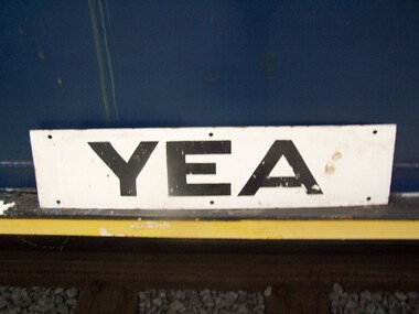 Puffing Billy Railway
Station Sign - Yea
Station Sign - Yea Yea Station Opened 16 November 1883 Closed 8 November 1978 Yea is a former railway station in Yea, Victoria, Australia. The tracks have been removed and the reserve has been turned into The Yea Railway Park consisting of the historic railway station and eleven acres of parkland. It has a picnic shelter, barbecue, toilets, playground, skatepark, walking track, community reserve and includes Rotary Park. The station building houses Blackthorn Textiles (a privately run craft shop). Also on the site are the former goods sheds which are available for hire for varied functions. The Yea Country Market is held in the park on the first Saturday of each month and local artists hold an exhibition and sale in the goods sheds each Easter. The site is listed on the Victorian Heritage Register ref: https://en.wikipedia.org/wiki/Yea_railway_station photo at http://vhd.heritagecouncil.vic.gov.au/vhd-images/places/000/078/092.jpg Historic - Victorian Railways Station sign used at Yea StationStation Sign - Yea Metal rectangle Station Name Sign with white enamel back ground and black lettersYeapuffing billy, station sign, yea station -
 City of Kingston
Photograph - Colour, Paul Tresize, 1998
The name Mordialloc was derived from the name Moody Yallock, which comes from the Bunurong language. The Bunurong Peoples are the Traditional Owners of this area. The name means “high water” or “high creek”. In 1839, colonial authorities declared the mouth of the creek, and an additional 830 odd acres as an Aboriginal Reserve, although this proclamation was never gazetted. The reserved land included part of the Carrum Carrum Swamp which was abundant with wild life and natural resources. Regular encroachments, including land sales which began in 1863, were made on the land until 1878 when the Reserve was declared closed, and the land was opened up to land sales. Market gardening and suburban house lots quickly began to develop, and Mordialloc became a renowned picnic and holiday site. Mordialloc Creek is a popular bay side destination for local and visitors, and is a site for boating, kayaking, fishing and swimming, along with many other activities.Colour photograph of Mordialloc Creek, looking out to the bay. Many small fishing and leisure craft are moored on either side of the banks of the creek. To the right hand side can be seen parklands, while the left hand side has a small inlet in which more small crafts are moored.mordialloc, bunurong, traditional owners, suburbs, boats, fishing, waterways -
 City of Kingston
Photograph - Colour, 1998
The name Mordialloc was derived from the name Moody Yallock, which comes from the Bunurong language. The Bunurong Peoples are the Traditional Owners of this area. The name means “high water” or “high creek”. In 1839, colonial authorities declared the mouth of the creek, and an additional 830 odd acres as an Aboriginal Reserve, although this proclamation was never gazetted. The reserved land included part of the Carrum Carrum Swamp which was abundant with wild life and natural resources. Regular encroachments, including land sales which began in 1863, were made on the land until 1878 when the Reserve was declared closed, and the land was opened up to land sales. Market gardening and suburban house lots quickly began to develop, and Mordialloc became a renowned picnic and holiday site. Mordialloc Creek is a popular bay side destination for local and visitors, and is a site for boating, kayaking, fishing and swimming, along with many other activities.Colour photograph of Mordialloc Creek, looking inland.Small fishing and leisure boats are moored on either side of creek, with a view of the Mordialloc Bridge Hotel in the background.mordialloc, bunurong, traditional owners, suburbs, boats, fishing, waterways, hotel -
City of Kingston
Photograph - Colour, Paul Tresize, 1998
The name Mordialloc was derived from the name Moody Yallock, which comes from the Bunurong language. The Bunurong Peoples are the Traditional Owners of this area. The name means “high water” or “high creek”. In 1839, colonial authorities declared the mouth of the creek, and an additional 830 odd acres as an Aboriginal Reserve, although this proclamation was never gazetted. The reserved land included part of the Carrum Carrum Swamp which was abundant with wild life and natural resources. Regular encroachments, including land sales which began in 1863, were made on the land until 1878 when the Reserve was declared closed, and the land was opened up to land sales. Market gardening and suburban house lots quickly began to develop, and Mordialloc became a renowned picnic and holiday site. Mordialloc Creek is a popular bay side destination for local and visitors, and is a site for boating, kayaking, fishing and swimming, along with many other activities.Colour photograph of Mordialloc Creek, looking inland. Boats are moored on either side of the creek and the Bridge Hotel is visible in the background.mordialloc, bunurong, traditional owners, suburbs, boats, fishing, waterways, hotel -
 City of Kingston
Photograph - Colour, Paul Tresize, 1998
The name Mordialloc was derived from the name Moody Yallock, which comes from the Bunurong language. The Bunurong Peoples are the Traditional Owners of this area. The name means “high water” or “high creek”. In 1839, colonial authorities declared the mouth of the creek, and an additional 830 odd acres as an Aboriginal Reserve, although this proclamation was never gazetted. The reserved land included part of the Carrum Carrum Swamp which was abundant with wild life and natural resources. Regular encroachments, including land sales which began in 1863, were made on the land until 1878 when the Reserve was declared closed, and the land was opened up to land sales. Market gardening and suburban house lots quickly began to develop, and Mordialloc became a renowned picnic and holiday site. Mordialloc Creek is a popular bay side destination for local and visitors, and is a site for boating, kayaking, fishing and swimming, along with many other activities.Colour photograph of Mordialloc Creek with boats moored on both sides of the street and Pompei's boat yard visible on the right hand side of the creek., Main Street and St Brigid's Catholic Church are visible in backgroundmordialloc, bunurong, traditional owners, suburbs, boats, fishing, waterways, hotel, church -
City of Kingston
Photograph - Colour, Paul Tresize, 1998
The name Mordialloc was derived from the name Moody Yallock, which comes from the Bunurong language. The Bunurong Peoples are the Traditional Owners of this area. The name means “high water” or “high creek”. In 1839, colonial authorities declared the mouth of the creek, and an additional 830 odd acres as an Aboriginal Reserve, although this proclamation was never gazetted. The reserved land included part of the Carrum Carrum Swamp which was abundant with wild life and natural resources. Regular encroachments, including land sales which began in 1863, were made on the land until 1878 when the Reserve was declared closed, and the land was opened up to land sales. Market gardening and suburban house lots quickly began to develop, and Mordialloc became a renowned picnic and holiday site. Mordialloc Creek is a popular bay side destination for local and visitors, and is a site for boating, kayaking, fishing and swimming, along with many other activities.Colour photograph of Mordialloc Creek with boats moored on both sides of the street and Pompei's boat yard visible on the right hand side of the creek., Main Street and St Brigid's Catholic Church are visible in background.mordialloc, bunurong, traditional owners, boats, fishing -
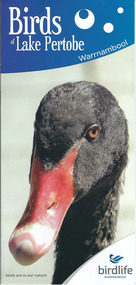 Warrnambool and District Historical Society Inc.
Document, Pamphlets lake Pertobe, 2014
Lake Pertobe in Warrnambool is a former swamp area which was transformed into a recreational area and children’s playground in the 1970s. The reserve is a popular spot for bird watching with over 80 species found in the vicinity. The brochure on Lake Pertobe’s birds had been produced by BirdLife Warrnambool, part of BirdLife Australia, an independent, not-for profit organisation aiming to protect our birdlife and disseminate information on Australian birds. This is an important little brochure as it contains information for locals and tourists about the birdlife in Lake Pertobe, one of the best-known and best-loved spots in WarrnamboolThis is an A3 sheet of paper printed on both sides and folded three times to form a brochure. It contains colour photographs of birds, two maps and information about BirdLife Warrnambool and BirdLife Australia and the logo of Birdlife Warrnambool.Front Cover: ‘Birds of Lake Pertobe, Warrnambool, BirdLife Warrnambool, Birds are in our nature’ lake pertobe, birdlife warrnambool, warrnambool -
 Eltham District Historical Society Inc
Photograph, Fred Mitchell, Looking east along Arthur Street just down from intersection with Bible Street, Eltham, 1968
Valiant is parked outside what was no. 43 now part of a unit complex at no. 41. Immediately in front of Valiant is no. 45, which has been a vacant block since before 1990. Gentleman in hat with paper walking up hill is outside no. 39, now a unit complex and the old house on left is no. 37 (since replaced) which borders what is now the Walter Withers ReserveDigital copy of colour photographfred mitchell collection, 1968, bible street, arthur street, eltham, houses, streets -
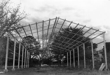 Ballarat Tramway Museum
Photograph - Black & White Photograph/s, The Courier Ballarat, 15/5/1972
Newspaper photograph taken by The Courier of the steel framework for the BTPS depot in the south Gardens reserve. Photo taken 15/5/1972, published 16/5/1972. See Reg. Item 2203 for the photo used in the newspaper clipping. Collected by Alan Bradley from the Ballarat Courier early 1980's. See Reg Item 4654 for a similar photo, along with 9434, and 3819.Yields information about the construction of the depot building for the BTPS in the south Gardens Reserve and the landscape at the time.Black and White copy photograph with publisher details on the rear.On rear stamped "Copyright, The Ballarat Courier Proprietary Limited."tramways, trams, btps, depot, gardens, buildings -
8th/13th Victorian Mounted Rifles Regimental Collection
Document, October 1988
In 1988, as part of a Defence of Mainland Australian policy, defence of facilities of strategic importance in northern Australia were allocated to Army Reserve units. ‘A’ Squadron was allocated the defence of Tindal Air Force base located 15 KM outside Katherine in Northern Territory. Consequently the Squadron deployed on Exercise ‘Northern Explorer’ to gain first-hand knowledge of operating conditions for mounted and dismounted patrolling in the area.Typed report on exercise ' Northern Explorer ' 15-20 September 1988 prepared by Captain G. Carrington ' A ' Squadron 8/13 Victorian Mounted Rifles. Seven pages, dated 1 October 1988. -
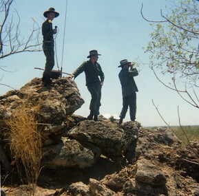 8th/13th Victorian Mounted Rifles Regimental Collection
Photograph
In 1988, as part of a Defence of Mainland Australian policy, defence of facilities of strategic importance in northern Australia were allocated to Army Reserve units. ‘A’ Squadron was allocated the defence of Tindal Air Force base located 15 KM outside Katherine in Northern Territory. Consequently the Squadron deployed on Exercise ‘Northern Explorer’ to gain first-hand knowledge of operating conditions for mounted and dismounted patrolling in the area.Colour photograph of three soldiers of ' A ' Squadron 8/13 VMR using a whip antenna to establish communication with their base while on patrol during exercise ' Northern Explorer.' -
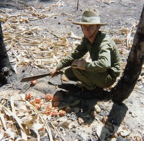 8th/13th Victorian Mounted Rifles Regimental Collection
Photograph
In 1988, as part of a Defence of Mainland Australian policy, defence of facilities of strategic importance in northern Australia were allocated to Army Reserve units. ‘A’ Squadron was allocated the defence of Tindal Air Force base located 15 KM outside Katherine in Northern Territory. Consequently the Squadron deployed on Exercise ‘Northern Explorer’ to gain first-hand knowledge of operating conditions for mounted and dismounted patrolling in the area.Lance Corporal R. Van De Velde, ' A ' Squadron 8/13 VMR during Exercise ' Northern Explorer' September 1988. LCpl Van De Velde has a collection of Pandamus Palm nut prematurely ripened by fire near King River Northern Territory. -
 8th/13th Victorian Mounted Rifles Regimental Collection
Photograph
In 1988, as part of a Defence of Mainland Australian policy, defence of facilities of strategic importance in northern Australia were allocated to Army Reserve units. ‘A’ Squadron was allocated the defence of Tindal Air Force base located 15 KM outside Katherine in Northern Territory. Consequently the Squadron deployed on Exercise ‘Northern Explorer’ to gain first-hand knowledge of operating conditions for mounted and dismounted patrolling in the area.Colour photograph of jaggered basalt rock covering most of high country SSW of Tindal RAAF Base, Northern Territory. Photo was taken to illustrate reports of patrols during Exercise " Northern Explorer" September 1988. -
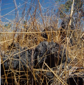
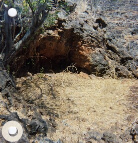 8th/13th Victorian Mounted Rifles Regimental Collection
Photograph
In 1988, as part of a Defence of Mainland Australian policy, defence of facilities of strategic importance in northern Australia were allocated to Army Reserve units. ‘A’ Squadron was allocated the defence of Tindal Air Force base located 15 KM outside Katherine in Northern Territory. Consequently the Squadron deployed on Exercise ‘Northern Explorer’ to gain first-hand knowledge of operating conditions for mounted and dismounted patrolling in the area.Two colour photographs of sink holes/rock depressions cbserved while on patrol during Exercise " Northern Explorer. These features offered the only shade when temperature was 41oC.