Showing 2136 items
matching technology
-
 Flagstaff Hill Maritime Museum and Village
Photograph - Shipwreck rescue, Royal Australian Navy (RAN), HMAS Warrnambool J202, 13-09-1947
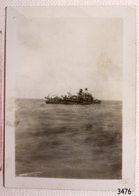
This photograph was taken at the scene of the wreck of the HMAS Warrnambool J202 on September 13th 1947. The photographer has captured the sinking ship with the crew still onboard. The HMAS Warrnambool J202 was commissioned by the Royal Australian Navy for use as a minesweeper during World War II. The Bathurst Class Corvette, fitted out with a range of armaments, was launched in Sydney in 1941 . The ship began service in Bass Strait in 1941. At the end of the year it called into its namesake city, Warrnambool, where the crew paraded for the public marching eastwards along Timor Street. A gift of books for the ship’s personnel and a plaque bearing the City of Warrnambool’s Coat of Arms were presented to the ship. The ship was involved in evacuating a family of nine from the Dutch East Indies that was later successful in its challenge of Australia’s Immigration Restriction Act (White Australia Polity). The ship had many other appointments around Australia. On 13th September 1947 HMAS Warrnambool was leading a flotilla of minesweepers in northern Queensland’s coastal waters, clearing mines previously laid to defend Australia. The ship hit a mine, which exploded and very quickly sunk the ship. Boats from the nearby ships rescued most of the seamen although one was killed at the time. The survivors were taken by the HMAS Swan II to Darwin, and they went from there to hospitals in Brisbane and Sydney. Three of these men later died from their injuries. A number of items were recovered by Navy divers in 1948 including the ship’s bell and a plaque with Warrnambool’s Coat of Arms. In 1972-75 the wreck was sold and other items were salvaged. In 1995 a memorial plaque was erected in Warrnambool near the RSL. NOTE: The RAN built a second HMAS Warrnambool FCPB204, launched in 1981 and decommissioned in 2005. There was also a steam ship SS Warrnambool built in London 1892 and broken up in 1926. [A more detailed history can be found in our Collection Record 3477.] This photograph is significant for its association with the lifesaving rescue of the crew and the sinking Royal Australian Navy vessel, HMAS Warrnambool (J202). The HMAS Warrnambool played a nationally significant role in overturning Australia’s Immigration Restriction Act 1901 (colloquially known as the White Australia policy). The ship rescued, and brought to Australia, Samuel and Annie Jacob and their family after they evacuated Dutch East India. The family was threatened with deportation and made the first successful appeal to High Court regarding that Act. The HMAS Warrnambool has - Local significance for being the namesake of the City of Warrnambool - Local significance, having docked in Warrnambool Harbour - Local significance, the crew having paraded in Timor Street, Warrnambool - State significance for its first patrol being in Bass Strait. - National significance, being present in Timor at the Japanese surrender - National significance, shown by the significance of the ship’s bell being curated as Military Heritage and Technology at the Australian War Memorial. - National significance as part of Australia’s defence force history, being one of only four Bathurst class corvettes lost while in Australian service, the only Bathurst class corvette lost after World War II, the only RAN vessel to be sunk by a mine, and associated with the last four Navy deaths of WWII Photograph of the sinking ship HMAS Warrnambool, sunk on 13-09-1947. Figures can be seen onboard the damaged vessel. The number of the ship-type is clearly visible on this starboard profile of the ship. This black and white photograph is one of a series of photographs taken at the time.Text on side of ship "J202"flagstaff hill, maritime village, maritime museum, warrnambool, shipwreck coast, mort's dock & engineering co ltd, h.m.a.s. warrnambool, hmas warrnambool, hmas warrnambool i, hmas warrnambool j202, hmas swan ii, j202, world war ii, bathurst class corvette, royal australian navy, ran, sydney built ship, bass strait patrol, sea mine patrol, mine sweeper, mine clearance, navy divers, great barrier reef, cockburn reef, southern cross diving and salvage, warrnambool city council, cr j r astbury, mayor j r astbury, warrnambool patriotic fund, seal, coat of arms, dedicatory plaque, hmas warrnambool 1941, shipwreck by sea mine 1947, sinking ship, sunk ship, sea rescue, life saving, lifesaving, minesweeper -
 Flagstaff Hill Maritime Museum and Village
Photograph - Shipwreck rescue, Royal Australian Navy (RAN), HMAS Warrnambool J202, 13-09-947
This photograph was taken at the scene of the wreck of the HMAS Warrnambool J202 on September 13th 1947. The photographer has captured the rescue boat approaching the sinking ship with the crew onboard. There small boat has several figures onboard. The HMAS Warrnambool J202 was commissioned by the Royal Australian Navy for use as a minesweeper during World War II. The Bathurst Class Corvette, fitted out with a range of armaments, was launched in Sydney in 1941. The ship began service in Bass Strait in 1941. At the end of the year it called into its namesake city, Warrnambool, where the crew paraded for the public marching eastwards along Timor Street. A gift of books for the ship’s personnel and a plaque bearing the City of Warrnambool’s Coat of Arms were presented to the ship. The ship was involved in evacuating a family of nine from the Dutch East Indies that was later successful in its challenge of Australia’s Immigration Restriction Act (White Australia Polity). The ship had many other appointments around Australia. On 13th September 1947 HMAS Warrnambool was leading a flotilla of minesweepers in northern Queensland’s coastal waters, clearing mines previously laid to defend Australia. The ship hit a mine, which exploded and very quickly sunk the ship. Boats from the nearby ships rescued most of the seamen although one was killed at the time. The survivors were taken by the HMAS Swan II to Darwin, and they went from there to hospitals in Brisbane and Sydney. Three of these men later died from their injuries. A number of items were recovered by Navy divers in 1948 including the ship’s bell and a plaque with Warrnambool’s Coat of Arms. In 1972-75 the wreck was sold and other items were salvaged. In 1995 a memorial plaque was erected in Warrnambool near the RSL. NOTE: The RAN built a second HMAS Warrnambool FCPB204, launched in 1981 and decommissioned in 2005. There was also a steam ship SS Warrnambool built in London 1892 and broken up in 1926. [A more detailed history can be found in our Collection Record 3477.] This photograph is significant for its association with the lifesaving rescue of the crew and the sinking Royal Australian Navy vessel, HMAS Warrnambool (J202). The HMAS Warrnambool played a nationally significant role in overturning Australia’s Immigration Restriction Act 1901 (colloquially known as the White Australia policy). The ship rescued, and brought to Australia, Samuel and Annie Jacob and their family after they evacuated Dutch East India. The family was threatened with deportation and made the first successful appeal to High Court regarding that Act. The HMAS Warrnambool has - Local significance for being the namesake of the City of Warrnambool - Local significance, having docked in Warrnambool Harbour - Local significance, the crew having paraded in Timor Street, Warrnambool - State significance for its first patrol being in Bass Strait. - National significance, being present in Timor at the Japanese surrender - National significance, shown by the significance of the ship’s bell being curated as Military Heritage and Technology at the Australian War Memorial. - National significance as part of Australia’s defence force history, being one of only four Bathurst class corvettes lost while in Australian service, the only Bathurst class corvette lost after World War II, the only RAN vessel to be sunk by a mine, and associated with the last four Navy deaths of WWII Photograph of rescue of the crew from shipwreck HMAS Warrnambool, sunk on 13-09-1947. Figures onboard a larger vessel look across at rescue vessel heading towards the sinking ship. This black and white photograph is one of a series of photographs taken at the time.flagstaff hill, maritime village, maritime museum, warrnambool, shipwreck coast, mort's dock & engineering co ltd, h.m.a.s. warrnambool, hmas warrnambool, hmas warrnambool i, hmas warrnambool j202, hmas swan ii, j202, world war ii, bathurst class corvette, royal australian navy, ran, sydney built ship, bass strait patrol, sea mine patrol, mine sweeper, mine clearance, navy divers, great barrier reef, cockburn reef, southern cross diving and salvage, warrnambool city council, cr j r astbury, mayor j r astbury, warrnambool patriotic fund, seal, coat of arms, dedicatory plaque, hmas warrnambool 1941, shipwreck by sea mine 1947, sinking ship, sunk ship, sea rescue, life saving, lifesaving, minesweeper -
 Flagstaff Hill Maritime Museum and Village
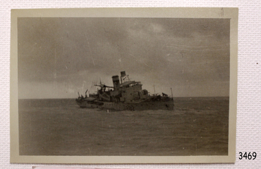
Photograph - Shipwreck rescue, Royal Australian Navy (RAN), HMAS Warrnambool J202, 13-09-1947
This photograph was taken at the scene of the wreck of the HMAS Warrnambool J202 on September 13th 1947. The photographer has captured the ship as it sinks at sea. The HMAS Warrnambool J202 was commissioned by the Royal Australian Navy for use as a minesweeper during World War II. The Bathurst Class Corvette, fitted out with a range of armaments, was launched in Sydney in 1941. The ship began service in Bass Strait in 1941. At the end of the year it called into its namesake city, Warrnambool, where the crew paraded for the public marching eastwards along Timor Street. A gift of books for the ship’s personnel and a plaque bearing the City of Warrnambool’s Coat of Arms were presented to the ship. The ship was involved in evacuating a family of nine from the Dutch East Indies that was later successful in its challenge of Australia’s Immigration Restriction Act (White Australia Polity). The ship had many other appointments around Australia. On 13th September 1947 HMAS Warrnambool was leading a flotilla of minesweepers in northern Queensland’s coastal waters, clearing mines previously laid to defend Australia. The ship hit a mine, which exploded and very quickly sunk the ship. Boats from the nearby ships rescued most of the seamen although one was killed at the time. The survivors were taken by the HMAS Swan II to Darwin, and they went from there to hospitals in Brisbane and Sydney. Three of these men later died from their injuries. A number of items were recovered by Navy divers in 1948 including the ship’s bell and a plaque with Warrnambool’s Coat of Arms. In 1972-75 the wreck was sold and other items were salvaged. In 1995 a memorial plaque was erected in Warrnambool near the RSL. NOTE: The RAN built a second HMAS Warrnambool FCPB204, launched in 1981 and decommissioned in 2005. There was also a steam ship SS Warrnambool built in London 1892 and broken up in 1926. [A more detailed history can be found in our Collection Record 3477.] This photograph is significant for its association with the lifesaving rescue of the crew and the sinking Royal Australian Navy vessel, HMAS Warrnambool (J202). The HMAS Warrnambool played a nationally significant role in overturning Australia’s Immigration Restriction Act 1901 (colloquially known as the White Australia policy). The ship rescued, and brought to Australia, Samuel and Annie Jacob and their family after they evacuated Dutch East India. The family was threatened with deportation and made the first successful appeal to High Court regarding that Act. The HMAS Warrnambool has - Local significance for being the namesake of the City of Warrnambool - Local significance, having docked in Warrnambool Harbour - Local significance, the crew having paraded in Timor Street, Warrnambool - State significance for its first patrol being in Bass Strait. - National significance, being present in Timor at the Japanese surrender - National significance, shown by the significance of the ship’s bell being curated as Military Heritage and Technology at the Australian War Memorial. - National significance as part of Australia’s defence force history, being one of only four Bathurst class corvettes lost while in Australian service, the only Bathurst class corvette lost after World War II, the only RAN vessel to be sunk by a mine, and associated with the last four Navy deaths of WWII Photograph of the sinking ship HMAS Warrnambool, sunk on 13-09-1947. The image shows the damaged ship tilting down on the starboard side. The ship-type number is still mostly visible. This black and white photograph is one of a series of photographs taken at the time.flagstaff hill, maritime village, maritime museum, warrnambool, shipwreck coast, mort's dock & engineering co ltd, h.m.a.s. warrnambool, hmas warrnambool, hmas warrnambool i, hmas warrnambool j202, hmas swan ii, j202, world war ii, bathurst class corvette, royal australian navy, ran, sydney built ship, bass strait patrol, sea mine patrol, mine sweeper, mine clearance, navy divers, great barrier reef, cockburn reef, southern cross diving and salvage, warrnambool city council, cr j r astbury, mayor j r astbury, warrnambool patriotic fund, seal, coat of arms, dedicatory plaque, hmas warrnambool 1941, shipwreck by sea mine 1947, sinking ship, sunk ship, sea rescue, life saving, lifesaving, minesweeper -
 Flagstaff Hill Maritime Museum and Village
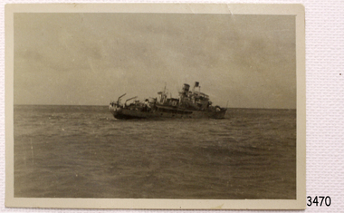
Photograph - Shipwreck rescue, Royal Australian Navy (RAN), HMAS Warrnambool J202, 13-09-1947
This photograph was taken at the scene of the wreck of the HMAS Warrnambool J202 on September 13th 1947. The photographer has captured the ship as it sinks at sea, with, it seems, crew still on board.. The HMAS Warrnambool J202 was commissioned by the Royal Australian Navy for use as a minesweeper during World War II. The Bathurst Class Corvette, fitted out with a range of armaments, was launched in Sydney in 1941. The ship began service in Bass Strait in 1941. At the end of the year it called into its namesake city, Warrnambool, where the crew paraded for the public marching eastwards along Timor Street. A gift of books for the ship’s personnel and a plaque bearing the City of Warrnambool’s Coat of Arms were presented to the ship. The ship was involved in evacuating a family of nine from the Dutch East Indies that was later successful in its challenge of Australia’s Immigration Restriction Act (White Australia Polity). The ship had many other appointments around Australia. On 13th September 1947 HMAS Warrnambool was leading a flotilla of minesweepers in northern Queensland’s coastal waters, clearing mines previously laid to defend Australia. The ship hit a mine, which exploded and very quickly sunk the ship. Boats from the nearby ships rescued most of the seamen although one was killed at the time. The survivors were taken by the HMAS Swan II to Darwin, and they went from there to hospitals in Brisbane and Sydney. Three of these men later died from their injuries. A number of items were recovered by Navy divers in 1948 including the ship’s bell and a plaque with Warrnambool’s Coat of Arms. In 1972-75 the wreck was sold and other items were salvaged. In 1995 a memorial plaque was erected in Warrnambool near the RSL. NOTE: The RAN built a second HMAS Warrnambool FCPB204, launched in 1981 and decommissioned in 2005. There was also a steam ship SS Warrnambool built in London 1892 and broken up in 1926. [A more detailed history can be found in our Collection Record 3477.] This photograph is significant for its association with the lifesaving rescue of the crew and the sinking Royal Australian Navy vessel, HMAS Warrnambool (J202). The HMAS Warrnambool played a nationally significant role in overturning Australia’s Immigration Restriction Act 1901 (colloquially known as the White Australia policy). The ship rescued, and brought to Australia, Samuel and Annie Jacob and their family after they evacuated Dutch East India. The family was threatened with deportation and made the first successful appeal to High Court regarding that Act. The HMAS Warrnambool has - Local significance for being the namesake of the City of Warrnambool - Local significance, having docked in Warrnambool Harbour - Local significance, the crew having paraded in Timor Street, Warrnambool - State significance for its first patrol being in Bass Strait. - National significance, being present in Timor at the Japanese surrender - National significance, shown by the significance of the ship’s bell being curated as Military Heritage and Technology at the Australian War Memorial. - National significance as part of Australia’s defence force history, being one of only four Bathurst class corvettes lost while in Australian service, the only Bathurst class corvette lost after World War II, the only RAN vessel to be sunk by a mine, and associated with the last four Navy deaths of WWII Photograph of the sinking ship HMAS Warrnambool, sunk on 13-09-1947. The image shows the ship leaning at an angle towards the sea. There appears to be figures near the bow. This black and white photograph is one of a series of photographs taken at the time.flagstaff hill, maritime village, maritime museum, warrnambool, shipwreck coast, mort's dock & engineering co ltd, h.m.a.s. warrnambool, hmas warrnambool, hmas warrnambool i, hmas warrnambool j202, hmas swan ii, j202, world war ii, bathurst class corvette, royal australian navy, ran, sydney built ship, bass strait patrol, sea mine patrol, mine sweeper, mine clearance, navy divers, great barrier reef, cockburn reef, southern cross diving and salvage, warrnambool city council, cr j r astbury, mayor j r astbury, warrnambool patriotic fund, seal, coat of arms, dedicatory plaque, hmas warrnambool 1941, shipwreck by sea mine 1947, sinking ship, sunk ship, sea rescue, life saving, lifesaving, minesweeper -
 Flagstaff Hill Maritime Museum and Village
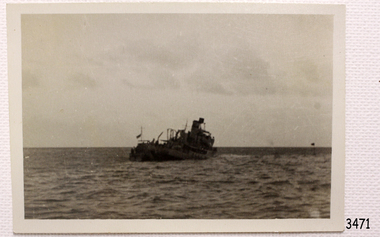
Photograph - Shipwreck rescue, Royal Australian Navy (RAN), HMAS Warrnambool J202, 13-09-1947
This photograph was taken at the scene of the wreck of the HMAS Warrnambool J202 on September 13th 1947. The photographer has captured the ship as it sinks at sea. The HMAS Warrnambool J202 was commissioned by the Royal Australian Navy for use as a minesweeper during World War II. The Bathurst Class Corvette, fitted out with a range of armaments, was launched in Sydney in 1941. The ship began service in Bass Strait in 1941. At the end of the year it called into its namesake city, Warrnambool, where the crew paraded for the public marching eastwards along Timor Street. A gift of books for the ship’s personnel and a plaque bearing the City of Warrnambool’s Coat of Arms were presented to the ship. The ship was involved in evacuating a family of nine from the Dutch East Indies that was later successful in its challenge of Australia’s Immigration Restriction Act (White Australia Polity). The ship had many other appointments around Australia. On 13th September 1947 HMAS Warrnambool was leading a flotilla of minesweepers in northern Queensland’s coastal waters, clearing mines previously laid to defend Australia. The ship hit a mine, which exploded and very quickly sunk the ship. Boats from the nearby ships rescued most of the seamen although one was killed at the time. The survivors were taken by the HMAS Swan II to Darwin, and they went from there to hospitals in Brisbane and Sydney. Three of these men later died from their injuries. A number of items were recovered by Navy divers in 1948 including the ship’s bell and a plaque with Warrnambool’s Coat of Arms. In 1972-75 the wreck was sold and other items were salvaged. In 1995 a memorial plaque was erected in Warrnambool near the RSL. NOTE: The RAN built a second HMAS Warrnambool FCPB204, launched in 1981 and decommissioned in 2005. There was also a steam ship SS Warrnambool built in London 1892 and broken up in 1926. [A more detailed history can be found in our Collection Record 3477.] This photograph is significant for its association with the lifesaving rescue of the crew and the sinking Royal Australian Navy vessel, HMAS Warrnambool (J202). The HMAS Warrnambool played a nationally significant role in overturning Australia’s Immigration Restriction Act 1901 (colloquially known as the White Australia policy). The ship rescued, and brought to Australia, Samuel and Annie Jacob and their family after they evacuated Dutch East India. The family was threatened with deportation and made the first successful appeal to High Court regarding that Act. The HMAS Warrnambool has - Local significance for being the namesake of the City of Warrnambool - Local significance, having docked in Warrnambool Harbour - Local significance, the crew having paraded in Timor Street, Warrnambool - State significance for its first patrol being in Bass Strait. - National significance, being present in Timor at the Japanese surrender - National significance, shown by the significance of the ship’s bell being curated as Military Heritage and Technology at the Australian War Memorial. - National significance as part of Australia’s defence force history, being one of only four Bathurst class corvettes lost while in Australian service, the only Bathurst class corvette lost after World War II, the only RAN vessel to be sunk by a mine, and associated with the last four Navy deaths of WWII Photograph of the sinking ship HMAS Warrnambool, sunk on 13-09-1947. The image shows the ship tilting towards port side and the bow dipping. This black and white photograph is one of a series of photographs taken at the time.flagstaff hill, maritime village, maritime museum, warrnambool, shipwreck coast, mort's dock & engineering co ltd, h.m.a.s. warrnambool, hmas warrnambool, hmas warrnambool i, hmas warrnambool j202, hmas swan ii, j202, world war ii, bathurst class corvette, royal australian navy, ran, sydney built ship, bass strait patrol, sea mine patrol, mine sweeper, mine clearance, navy divers, great barrier reef, cockburn reef, southern cross diving and salvage, warrnambool city council, cr j r astbury, mayor j r astbury, warrnambool patriotic fund, seal, coat of arms, dedicatory plaque, hmas warrnambool 1941, shipwreck by sea mine 1947, sinking ship, sunk ship, sea rescue, life saving, lifesaving, minesweeper -
 Flagstaff Hill Maritime Museum and Village
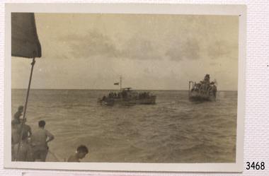
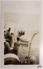
Photograph - Shipwreck rescue, Royal Australian Navy (RAN), 13-09-1947
This photograph was taken at the scene of the wreck of the HMAS Warrnambool J202 on September 13th 1947. The photographer has captured the crew being rescued, transferring from one vessel to another, which is likely to be the HMAS Swan II. The HMAS Warrnambool J202 was commissioned by the Royal Australian Navy for use as a minesweeper during World War II. The Bathurst Class Corvette, fitted out with a range of armaments, was launched in Sydney 1941. The ship began service in Bass Strait in 1941. At the end of the year it called into its namesake city, Warrnambool, where the crew paraded for the public marching eastwards along Timor Street. A gift of books for the ship’s personnel and a plaque bearing the City of Warrnambool’s Coat of Arms were presented to the ship. The ship was involved in evacuating a family of nine from the Dutch East Indies that was later successful in its challenge of Australia’s Immigration Restriction Act (White Australia Polity). The ship had many other appointments around Australia. On 13th September 1947 HMAS Warrnambool was leading a flotilla of minesweepers in northern Queensland’s coastal waters, clearing mines previously laid to defend Australia. The ship hit a mine, which exploded and very quickly sunk the ship. Boats from the nearby ships rescued most of the seamen although one was killed at the time. The survivors were taken by the HMAS Swan II to Darwin, and they went from there to hospitals in Brisbane and Sydney. Three of these men later died from their injuries. A number of items were recovered by Navy divers in 1948 including the ship’s bell and a plaque with Warrnambool’s Coat of Arms. In 1972-75 the wreck was sold and other items were salvaged. In 1995 a memorial plaque was erected in Warrnambool near the RSL. NOTE: The RAN built a second HMAS Warrnambool FCPB204, launched in 1981 and decommissioned in 2005. There was also a steam ship SS Warrnambool built in London 1892 and broken up in 1926. [A more detailed history can be found in our Collection Record 3477.] This photograph is significant for its association with the lifesaving rescue of the crew and the sinking Royal Australian Navy vessel, HMAS Warrnambool (J202). The HMAS Warrnambool played a nationally significant role in overturning Australia’s Immigration Restriction Act 1901 (colloquially known as the White Australia policy). The ship rescued, and brought to Australia, Samuel and Annie Jacob and their family after they evacuated Dutch East India. The family was threatened with deportation and made the first successful appeal to High Court regarding that Act. The HMAS Warrnambool has - Local significance for being the namesake of the City of Warrnambool - Local significance, having docked in Warrnambool Harbour - Local significance, the crew having paraded in Timor Street, Warrnambool - State significance for its first patrol being in Bass Strait. - National significance, being present in Timor at the Japanese surrender - National significance, shown by the significance of the ship’s bell being curated as Military Heritage and Technology at the Australian War Memorial. - National significance as part of Australia’s defence force history, being one of only four Bathurst class corvettes lost while in Australian service, the only Bathurst class corvette lost after World War II, the only RAN vessel to be sunk by a mine, and associated with the last four Navy deaths of WWII Photograph of the rescue of the crew from shipwreck HMAS Warrnambool, sunk on 13-09-1947. Survivors are helped from one vessel to another by seamen. This black and white photograph is one of a series of photographs taken at the time.flagstaff hill, maritime village, maritime museum, warrnambool, shipwreck coast, mort's dock & engineering co ltd, h.m.a.s. warrnambool, hmas warrnambool, hmas warrnambool i, hmas warrnambool j202, hmas swan ii, j202, world war ii, bathurst class corvette, royal australian navy, ran, sydney built ship, bass strait patrol, sea mine patrol, mine sweeper, mine clearance, navy divers, great barrier reef, cockburn reef, southern cross diving and salvage, warrnambool city council, cr j r astbury, mayor j r astbury, warrnambool patriotic fund, seal, coat of arms, dedicatory plaque, hmas warrnambool 1941, shipwreck by sea mine 1947, sinking ship, sunk ship, sea rescue, life saving, lifesaving, minesweeper -
 Flagstaff Hill Maritime Museum and Village
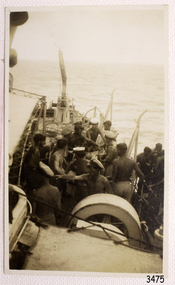
Photograph - Shipwreck rescue, Royal Australian Navy (RAN), 13-09-1947
This photograph was taken at the scene of the wreck of the HMAS Warrnambool J202 on September 13th 1947. The photographer has captured the crew being rescued. The HMAS Warrnambool J202 was commissioned by the Royal Australian Navy for use as a minesweeper during World War II. The Bathurst Class Corvette, fitted out with a range of armaments, was launched in Sydney, 1941. The ship began service in Bass Strait in 1941. At the end of the year it called into its namesake city, Warrnambool, where the crew paraded for the public marching eastwards along Timor Street. A gift of books for the ship’s personnel and a plaque bearing the City of Warrnambool’s Coat of Arms were presented to the ship. The ship was involved in evacuating a family of nine from the Dutch East Indies that was later successful in its challenge of Australia’s Immigration Restriction Act (White Australia Polity). The ship had many other appointments around Australia. On 13th September 1947 HMAS Warrnambool was leading a flotilla of minesweepers in northern Queensland’s coastal waters, clearing mines previously laid to defend Australia. The ship hit a mine, which exploded and very quickly sunk the ship. Boats from the nearby ships rescued most of the seamen although one was killed at the time. The survivors were taken by the HMAS Swan II to Darwin, and they went from there to hospitals in Brisbane and Sydney. Three of these men later died from their injuries. A number of items were recovered by Navy divers in 1948 including the ship’s bell and a plaque with Warrnambool’s Coat of Arms. In 1972-75 the wreck was sold and other items were salvaged. In 1995 a memorial plaque was erected in Warrnambool near the RSL. NOTE: The RAN built a second HMAS Warrnambool FCPB204, launched in 1981 and decommissioned in 2005. There was also a steam ship SS Warrnambool built in London 1892 and broken up in 1926. [A more detailed history can be found in our Collection Record 3477.] This photograph is significant for its association with the lifesaving rescue of the crew and the sinking Royal Australian Navy vessel, HMAS Warrnambool (J202). The HMAS Warrnambool played a nationally significant role in overturning Australia’s Immigration Restriction Act 1901 (colloquially known as the White Australia policy). The ship rescued, and brought to Australia, Samuel and Annie Jacob and their family after they evacuated Dutch East India. The family was threatened with deportation and made the first successful appeal to High Court regarding that Act. The HMAS Warrnambool has - Local significance for being the namesake of the City of Warrnambool - Local significance, having docked in Warrnambool Harbour - Local significance, the crew having paraded in Timor Street, Warrnambool - State significance for its first patrol being in Bass Strait. - National significance, being present in Timor at the Japanese surrender - National significance, shown by the significance of the ship’s bell being curated as Military Heritage and Technology at the Australian War Memorial. - National significance as part of Australia’s defence force history, being one of only four Bathurst class corvettes lost while in Australian service, the only Bathurst class corvette lost after World War II, the only RAN vessel to be sunk by a mine, and associated with the last four Navy deaths of WWII Photograph of the rescue of the crew from shipwreck HMAS Warrnambool, sunk on 13-09-1947. The image shows injured men being assisted onboard a vessel at sea. This black and white photograph is one of a series of photographs taken at the time.flagstaff hill, maritime village, maritime museum, warrnambool, shipwreck coast, mort's dock & engineering co ltd, h.m.a.s. warrnambool, hmas warrnambool, hmas warrnambool i, hmas warrnambool j202, hmas swan ii, j202, world war ii, bathurst class corvette, royal australian navy, ran, sydney built ship, bass strait patrol, sea mine patrol, mine sweeper, mine clearance, navy divers, great barrier reef, cockburn reef, southern cross diving and salvage, warrnambool city council, cr j r astbury, mayor j r astbury, warrnambool patriotic fund, seal, coat of arms, dedicatory plaque, hmas warrnambool 1941, shipwreck by sea mine 1947, sinking ship, sunk ship, sea rescue, life saving, lifesaving, minesweeper -
 Flagstaff Hill Maritime Museum and Village
Photograph - Shipwreck rescue, Royal Australian Navy (RAN), 13-09-1947
This photograph was taken at the scene of the wreck of the HMAS Warrnambool J202 on September 13th 1947. The photographer has captured the crew being rescued. The HMAS Warrnambool J202 was commissioned by the Royal Australian Navy for use as a minesweeper during World War II. The Bathurst Class Corvette, fitted out with a range of armaments, was launched in Sydney 1941. The ship began service in Bass Strait in 1941. At the end of the year it called into its namesake city, Warrnambool, where the crew paraded for the public marching eastwards along Timor Street. A gift of books for the ship’s personnel and a plaque bearing the City of Warrnambool’s Coat of Arms were presented to the ship. The ship was involved in evacuating a family of nine from the Dutch East Indies that was later successful in its challenge of Australia’s Immigration Restriction Act (White Australia Polity). The ship had many other appointments around Australia. On 13th September 1947 HMAS Warrnambool was leading a flotilla of minesweepers in northern Queensland’s coastal waters, clearing mines previously laid to defend Australia. The ship hit a mine, which exploded and very quickly sunk the ship. Boats from the nearby ships rescued most of the seamen although one was killed at the time. The survivors were taken by the HMAS Swan II to Darwin, and they went from there to hospitals in Brisbane and Sydney. Three of these men later died from their injuries. A number of items were recovered by Navy divers in 1948 including the ship’s bell and a plaque with Warrnambool’s Coat of Arms. In 1972-75 the wreck was sold and other items were salvaged. In 1995 a memorial plaque was erected in Warrnambool near the RSL. NOTE: The RAN built a second HMAS Warrnambool FCPB204, launched in 1981 and decommissioned in 2005. There was also a steam ship SS Warrnambool built in London 1892 and broken up in 1926. [A more detailed history can be found in our Collection Record 3477.] This photograph is significant for its association with the lifesaving rescue of the crew and the sinking Royal Australian Navy vessel, HMAS Warrnambool (J202). The HMAS Warrnambool played a nationally significant role in overturning Australia’s Immigration Restriction Act 1901 (colloquially known as the White Australia policy). The ship rescued, and brought to Australia, Samuel and Annie Jacob and their family after they evacuated Dutch East India. The family was threatened with deportation and made the first successful appeal to High Court regarding that Act. The HMAS Warrnambool has - Local significance for being the namesake of the City of Warrnambool - Local significance, having docked in Warrnambool Harbour - Local significance, the crew having paraded in Timor Street, Warrnambool - State significance for its first patrol being in Bass Strait. - National significance, being present in Timor at the Japanese surrender - National significance, shown by the significance of the ship’s bell being curated as Military Heritage and Technology at the Australian War Memorial. - National significance as part of Australia’s defence force history, being one of only four Bathurst class corvettes lost while in Australian service, the only Bathurst class corvette lost after World War II, the only RAN vessel to be sunk by a mine, and associated with the last four Navy deaths of WWII Photograph of the rescue of the crew from shipwreck HMAS Warrnambool, sunk on 13-09-1947. Image shows men in a lifeboat beside men in a ship, at sea. This black and white photograph is one of a series of photographs taken at the time.flagstaff hill, maritime village, maritime museum, warrnambool, shipwreck coast, mort's dock & engineering co ltd, h.m.a.s. warrnambool, hmas warrnambool, hmas warrnambool i, hmas warrnambool j202, hmas swan ii, j202, world war ii, bathurst class corvette, royal australian navy, ran, sydney built ship, bass strait patrol, sea mine patrol, mine sweeper, mine clearance, navy divers, great barrier reef, cockburn reef, southern cross diving and salvage, warrnambool city council, cr j r astbury, mayor j r astbury, warrnambool patriotic fund, seal, coat of arms, dedicatory plaque, hmas warrnambool 1941, shipwreck by sea mine 1947, sinking ship, sunk ship, sea rescue, life saving, lifesaving, minesweeper -
 Flagstaff Hill Maritime Museum and Village
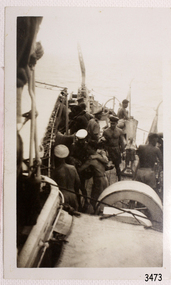
Photograph - Shipwreck rescue, Royal Australian Navy (RAN), 13-09-1947
This photograph was taken at the scene of the wreck of the HMAS Warrnambool J202 on September 13th 1947. The photographer has captured the crew being rescued, transferring from a lifeboat to the ship. The HMAS Warrnambool J202 was commissioned by the Royal Australian Navy for use as a minesweeper during World War II. The Bathurst Class Corvette, fitted out with a range of armaments, was launched in Sydney 1941. The ship began service in Bass Strait in 1941. At the end of the year it called into its namesake city, Warrnambool, where the crew paraded for the public marching eastwards along Timor Street. A gift of books for the ship’s personnel and a plaque bearing the City of Warrnambool’s Coat of Arms were presented to the ship. The ship was involved in evacuating a family of nine from the Dutch East Indies that was later successful in its challenge of Australia’s Immigration Restriction Act (White Australia Polity). The ship had many other appointments around Australia. On 13th September 1947 HMAS Warrnambool was leading a flotilla of minesweepers in northern Queensland’s coastal waters, clearing mines previously laid to defend Australia. The ship hit a mine, which exploded and very quickly sunk the ship. Boats from the nearby ships rescued most of the seamen although one was killed at the time. The survivors were taken by the HMAS Swan II to Darwin, and they went from there to hospitals in Brisbane and Sydney. Three of these men later died from their injuries. A number of items were recovered by Navy divers in 1948 including the ship’s bell and a plaque with Warrnambool’s Coat of Arms. In 1972-75 the wreck was sold and other items were salvaged. In 1995 a memorial plaque was erected in Warrnambool near the RSL. NOTE: The RAN built a second HMAS Warrnambool FCPB204, launched in 1981 and decommissioned in 2005. There was also a steam ship SS Warrnambool built in London 1892 and broken up in 1926. [A more detailed history can be found in our Collection Record 3477.] This photograph is significant for its association with the lifesaving rescue of the crew and the sinking Royal Australian Navy vessel, HMAS Warrnambool (J202). The HMAS Warrnambool played a nationally significant role in overturning Australia’s Immigration Restriction Act 1901 (colloquially known as the White Australia policy). The ship rescued, and brought to Australia, Samuel and Annie Jacob and their family after they evacuated Dutch East India. The family was threatened with deportation and made the first successful appeal to High Court regarding that Act. The HMAS Warrnambool has - Local significance for being the namesake of the City of Warrnambool - Local significance, having docked in Warrnambool Harbour - Local significance, the crew having paraded in Timor Street, Warrnambool - State significance for its first patrol being in Bass Strait. - National significance, being present in Timor at the Japanese surrender - National significance, shown by the significance of the ship’s bell being curated as Military Heritage and Technology at the Australian War Memorial. - National significance as part of Australia’s defence force history, being one of only four Bathurst class corvettes lost while in Australian service, the only Bathurst class corvette lost after World War II, the only RAN vessel to be sunk by a mine, and associated with the last four Navy deaths of WWII Photograph of the rescue of the crew from shipwreck HMAS Warrnambool, sunk on 13-09-1947. The image shows men being taken onboard a ship from a small boat. This black and white photograph is one of a series of photographs taken at the time.flagstaff hill, maritime village, maritime museum, warrnambool, shipwreck coast, mort's dock & engineering co ltd, h.m.a.s. warrnambool, hmas warrnambool, hmas warrnambool i, hmas warrnambool j202, hmas swan ii, j202, world war ii, bathurst class corvette, royal australian navy, ran, sydney built ship, bass strait patrol, sea mine patrol, mine sweeper, mine clearance, navy divers, great barrier reef, cockburn reef, southern cross diving and salvage, warrnambool city council, cr j r astbury, mayor j r astbury, warrnambool patriotic fund, seal, coat of arms, dedicatory plaque, hmas warrnambool 1941, shipwreck by sea mine 1947, sinking ship, sunk ship, sea rescue, life saving, lifesaving, minesweeper -
 Flagstaff Hill Maritime Museum and Village
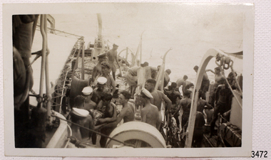
Photograph - Shipwreck rescue, Royal Australian Navy (RAN), HMAS Warrnambool J202, 13-09-1947
This photograph was taken at the scene of the wreck of the HMAS Warrnambool J202 on September 13th 1947. Figures can be seen on deck. The photographer has captured the ship as it sinks at sea. The HMAS Warrnambool J202 was commissioned by the Royal Australian Navy for use as a minesweeper during World War II. The Bathurst Class Corvette, fitted out with a range of armaments, was launched in Sydney 1941. The ship began service in Bass Strait in 1941. At the end of the year it called into its namesake city, Warrnambool, where the crew paraded for the public marching eastwards along Timor Street. A gift of books for the ship’s personnel and a plaque bearing the City of Warrnambool’s Coat of Arms were presented to the ship. The ship was involved in evacuating a family of nine from the Dutch East Indies that was later successful in its challenge of Australia’s Immigration Restriction Act (White Australia Polity). The ship had many other appointments around Australia. On 13th September 1947 HMAS Warrnambool was leading a flotilla of minesweepers in northern Queensland’s coastal waters, clearing mines previously laid to defend Australia. The ship hit a mine, which exploded and very quickly sunk the ship. Boats from the nearby ships rescued most of the seamen although one was killed at the time. The survivors were taken by the HMAS Swan II to Darwin, and they went from there to hospitals in Brisbane and Sydney. Three of these men later died from their injuries. A number of items were recovered by Navy divers in 1948 including the ship’s bell and a plaque with Warrnambool’s Coat of Arms. In 1972-75 the wreck was sold and other items were salvaged. In 1995 a memorial plaque was erected in Warrnambool near the RSL. NOTE: The RAN built a second HMAS Warrnambool FCPB204, launched in 1981 and decommissioned in 2005. There was also a steam ship SS Warrnambool built in London 1892 and broken up in 1926. [A more detailed history can be found in our Collection Record 3477.] This photograph is significant for its association with the lifesaving rescue of the crew and the sinking Royal Australian Navy vessel, HMAS Warrnambool (J202). The HMAS Warrnambool played a nationally significant role in overturning Australia’s Immigration Restriction Act 1901 (colloquially known as the White Australia policy). The ship rescued, and brought to Australia, Samuel and Annie Jacob and their family after they evacuated Dutch East India. The family was threatened with deportation and made the first successful appeal to High Court regarding that Act. The HMAS Warrnambool has - Local significance for being the namesake of the City of Warrnambool - Local significance, having docked in Warrnambool Harbour - Local significance, the crew having paraded in Timor Street, Warrnambool - State significance for its first patrol being in Bass Strait. - National significance, being present in Timor at the Japanese surrender - National significance, shown by the significance of the ship’s bell being curated as Military Heritage and Technology at the Australian War Memorial. - National significance as part of Australia’s defence force history, being one of only four Bathurst class corvettes lost while in Australian service, the only Bathurst class corvette lost after World War II, the only RAN vessel to be sunk by a mine, and associated with the last four Navy deaths of WWII Photograph of the sinking ship HMAS Warrnambool, sunk on 13-09-1947. The image shows the damaged and listing ship in the sea with figures on deck. This black and white photograph is one of a series of photographs taken at the time. "HMAS Warrnambool being sunk by mine", "sunk in Queensland waters 13 September 1947"flagstaff hill, maritime village, maritime museum, warrnambool, shipwreck coast, mort's dock & engineering co ltd, h.m.a.s. warrnambool, hmas warrnambool, hmas warrnambool i, hmas warrnambool j202, hmas swan ii, j202, world war ii, bathurst class corvette, royal australian navy, ran, sydney built ship, bass strait patrol, sea mine patrol, mine sweeper, mine clearance, navy divers, great barrier reef, cockburn reef, southern cross diving and salvage, warrnambool city council, cr j r astbury, mayor j r astbury, warrnambool patriotic fund, seal, coat of arms, dedicatory plaque, hmas warrnambool 1941, shipwreck by sea mine 1947, sinking ship, sunk ship, sea rescue, life saving, lifesaving, minesweeper -
 Flagstaff Hill Maritime Museum and Village
Photograph - Ship's crew, HMAS Warrnambool J202, Between 1941-1947
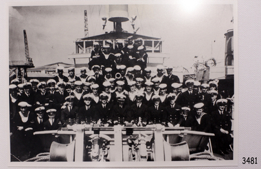
This formal photograph shows the crew of the HMAS Warrnambool standing in rows on the deck of the ship while it is in port. The HMAS Warrnambool J202 was commissioned by the Royal Australian Navy for use as a minesweeper during World War II. The Bathurst Class Corvette, fitted out with a range of armaments, was launched in Sydney 1941. The ship began service in Bass Strait in 1941. At the end of the year it called into its namesake city, Warrnambool, where the crew paraded for the public marching eastwards along Timor Street. A gift of books for the ship’s personnel and a plaque bearing the City of Warrnambool’s Coat of Arms were presented to the ship. The ship was involved in evacuating a family of nine from the Dutch East Indies that was later successful in its challenge of Australia’s Immigration Restriction Act (White Australia Polity). The ship had many other appointments around Australia. On 13th September 1947 HMAS Warrnambool was leading a flotilla of minesweepers in northern Queensland’s coastal waters, clearing mines previously laid to defend Australia. The ship hit a mine, which exploded and very quickly sunk the ship. Boats from the nearby ships rescued most of the seamen although one was killed at the time. The survivors were taken by the HMAS Swan II to Darwin, and they went from there to hospitals in Brisbane and Sydney. Three of these men later died from their injuries. A number of items were recovered by Navy divers in 1948 including the ship’s bell and a plaque with Warrnambool’s Coat of Arms. In 1972-75 the wreck was sold and other items were salvaged. In 1995 a memorial plaque was erected in Warrnambool near the RSL. NOTE: The RAN built a second HMAS Warrnambool FCPB204, launched in 1981 and decommissioned in 2005. There was also a steam ship SS Warrnambool built in London 1892 and broken up in 1926. [A more detailed history can be found in our Collection Record 3477.] This photograph is significant for its association with the lifesaving rescue of the crew and the sinking Royal Australian Navy vessel, HMAS Warrnambool (J202). The HMAS Warrnambool played a nationally significant role in overturning Australia’s Immigration Restriction Act 1901 (colloquially known as the White Australia policy). The ship rescued, and brought to Australia, Samuel and Annie Jacob and their family after they evacuated Dutch East India. The family was threatened with deportation and made the first successful appeal to High Court regarding that Act. The HMAS Warrnambool has - Local significance for being the namesake of the City of Warrnambool - Local significance, having docked in Warrnambool Harbour - Local significance, the crew having paraded in Timor Street, Warrnambool - State significance for its first patrol being in Bass Strait. - National significance, being present in Timor at the Japanese surrender - National significance, shown by the significance of the ship’s bell being curated as Military Heritage and Technology at the Australian War Memorial. - National significance as part of Australia’s defence force history, being one of only four Bathurst class corvettes lost while in Australian service, the only Bathurst class corvette lost after World War II, the only RAN vessel to be sunk by a mine, and associated with the last four Navy deaths of WWII Photograph of the crew of HMAS Warrnambool (I). This black and white image shows the crew formally standing in rows on the bow of the ship, which is docked. Inscription on back. (PRIVATE details, see Notes)flagstaff hill, maritime village, maritime museum, warrnambool, shipwreck coast, mort's dock & engineering co ltd, h.m.a.s. warrnambool, hmas warrnambool, hmas warrnambool i, hmas warrnambool j202, j202, world war ii, bathurst class corvette, royal australian navy, ran, sydney built ship, bass strait patrol, sea mine patrol, mine sweeper, mine clearance, navy divers, great barrier reef, cockburn reef, southern cross diving and salvage, warrnambool city council, seal, coat of arms, dedicatory plaque, hmas warrnambool 1941, shipwreck by sea mine 1947, minesweeper -
 Flagstaff Hill Maritime Museum and Village
Photograph - Ship's crew, HMAS Warrnambool J202, 1941
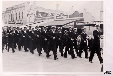
This photograph shows the crew of the first HMAS Warrnambool (J202) marching east along Timor Street in Warrnambool, just opposite the Post Office on the corner of Gillies Street. People are watching the parade from the footpath and two boys, dressed in their ‘best’ clothes, are marching alongside the crew. The HMAS Warrnambool was one of 60 Bathurst class corvette vessels built during World War II for the Royal Australian Navy (RAN) as armed minesweepers. The namesake of the City of Warrnambool, Victoria, was launched in Sydney in 1941. The HMAS Warrnambool began service with patrols off Bass Strait in 1941. In December the ship docked in the Warrnambool harbour at Lady Bay. The crew came ashore and performed a march for the city. The Mayor, Cr. John R Astbury presented them with a plaque of the City of Warrnambool’s Coat of Arms and the Warrnambool Patriotic Fund gave them a gift of 110 books for the crew’s library. The Warrnambool served in Darwin during the time it was bombed, it was involved in several rescues and carried troops to New Guinea, it carried out escort and patrol duties on Australia's east coast, then at Fremantle and back to Darwin. The ship was at Timor when the Japanese surrendered in 1945. It performed mine clearance work around the Solomon Islands and New Guinea after the war. In 1947 the HMAS Warrnambool was at the Great Barrier Reef, off the Queensland coast, to clear the defensive British mines previously laid to protect Australia’s boarders. The ship hit a mine near Cockburn Reef, exploded and sank shortly afterwards. One of the 70 or so men on board was killed and three died later. The rescued men were transferred by boats to the nearby HMAS Swan II, which took the survivors to Cairns. The four deceased were Victorian seamen. In May 1948 the Royal Australian Navy divers recovered a number of items from the wreck, including the ship’s bell and the City of Warrnambool plaque. In 1949 the RAN returned the plaque to the Warrnambool City Council, and donated the ship’s bell to the Australian War Memorial. Further objects were recovered in 1972-75 by Southern Cross Diving and Salvage. A memorial plaque was erected in Warrnambool on September 13, 1995 in honour of all who served on HMAS Warrnambool. NOTE: (1)- HMAS Warrnambool II (FCPB204 was built in 1980 in Cairns, with a compliment of 22 personnel. It was decommissioned in 2005. (2)- SS Warrnambool, a steam and sail ship, was built in 1892 in London and broken up in 1926. [A more detailed history can be found in our Collection Record 3477.]This photograph is significant for its association with the lifesaving rescue of the crew and the sinking Royal Australian Navy vessel, HMAS Warrnambool (J202). The HMAS Warrnambool played a nationally significant role in overturning Australia’s Immigration Restriction Act 1901 (colloquially known as the White Australia policy). The ship rescued, and brought to Australia, Samuel and Annie Jacob and their family after they evacuated Dutch East India. The family was threatened with deportation and made the first successful appeal to High Court regarding that Act. The HMAS Warrnambool has - Local significance for being the namesake of the City of Warrnambool - Local significance, having docked in Warrnambool Harbour - Local significance, the crew having paraded in Timor Street, Warrnambool - State significance for its first patrol being in Bass Strait. - National significance, being present in Timor at the Japanese surrender - National significance, shown by the significance of the ship’s bell being curated as Military Heritage and Technology at the Australian War Memorial. - National significance as part of Australia’s defence force history, being one of only four Bathurst class corvettes lost while in Australian service, the only Bathurst class corvette lost after World War II, the only RAN vessel to be sunk by a mine, and associated with the last four Navy deaths of WWIIPhotograph of the crew of HMAS Warrnambool J202. This black and white image shows the crew marching east along Timor Street in Warrnambool. People are watching from the footpath and two formally dressed boys are marching alongside the sailors. Inscription on the reverse.(PRIVATE details - See Notes)flagstaff hill, maritime village, maritime museum, warrnambool, shipwreck coast, mort's dock & engineering co ltd, h.m.a.s. warrnambool, hmas warrnambool, hmas warrnambool i, hmas warrnambool j202, hmas swan ii, j202, world war ii, bathurst class corvette, royal australian navy, ran, sydney built ship, bass strait patrol, sea mine patrol, mine sweeper, mine clearance, navy divers, great barrier reef, cockburn reef, southern cross diving and salvage, warrnambool city council, cr j r astbury, mayor j r astbury, warrnambool patriotic fund, seal, coat of arms, dedicatory plaque, hmas warrnambool 1941, shipwreck by sea mine 1947, sinking ship, sunk ship, marching, parade, timor street warrnambool, minesweeper -
 Flagstaff Hill Maritime Museum and Village
Photograph - Diver, K Tregea, 1900s
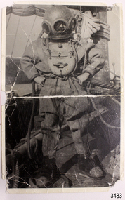
This photograph of a deep sea diver on board a vessel is connected to T. Ward. It was possibly part of E.G. Ward's Collection of diving equipment. The photograph was produced in the local town of Timboon. This photograph of an early 1900s diving suit shows part of the history of diving. It is connected to local history through the inscriptions on the back of the photograph; the printer and the name. The south west coast has hundreds of shipwrecks that have been discovered and explored by many divers. Their discoveries have led to us interpreting and understanding more about our history; ship building, exports, immigration, navigation and much more.Black and white photograph, portrait orientation, of a diver dressed in full diving gear standing on board a sailing vessel at sea. Inscriptions on reverse.Handwritten in black pen "T. WARD" Stamped in black ink "REPRODUCED BY" above rectangular stamp. Text within stamp "[K. TREGEA / CALLOWAY ST / TIMBOON VIC"flagstaff hill, warrnambool, shipwrecked-coast, flagstaff-hill, flagstaff-hill-maritime-museum, maritime-museum, shipwreck-coast, flagstaff-hill-maritime-village, photograph, diving gear, diving suit, deep sea diving, deep sea diver, diver, south west victoria, diving photograph, t ward, k tregea, timboon, marine technology, life saving -
 Flagstaff Hill Maritime Museum and Village
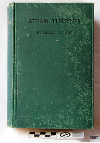
Book - Reference, William J Goudie, D. Sc., Professor (William john Goudie), Steam Turbines, 1922
This textbook was written for engineering students by Scottish Professor, William J Goudie, D. Sc., (1868-1945). He was a member of the Institution of Mechanical Engineers, a member of the Institution of Engineers and Shipbuilders in Scotland, an Associate Member of the Institution of Civil Engineers, James Watt Chair of Mechanical Engineering, University of Glasgow, and Professor of "The Theory and practice of Heat Engines" in the University of Glasgow. He wrote several papers and books on the topics of mechanical speed and power. The publisher firm, Longmans, Green & Co., was originally founded in 1724 in London by Thomas Longman under the name Longman. In August of that year, he bought the two shops and goods of William Taylor and set up his publishing house there at 39 Paternoster Row. The shops were called Black Swan and Ship, and it is said that the 'ship' sign was the inspiration for Longman's Logo. After many changes of name and management, the firm was incorporated in 1926 as Longmans, Green & Co. Pty Ltd. The firm was acquired by Pearson in 1968 and was known as Pearson Longman or Pearson PLC. The first practical steam turbine was built in 1884 by Charles Parsons and this became the beginning of generating electricity and powering large ships. The author of Steam Turbines, Professor William John Couldie D. Sc, was a mechanical engineer who had practical experience in a marine consulting engineering service and lectured in the theory and practice of mechanical engineering.This book is an example of the development of technology that contributed to the evolution of steam turbines. The book is also significant for its connection to the publisher Longmans, Green and Co., of London, a firm that has been established for over two centuries, renowned for publishing encyclopedias, dictionaries, books on English grammar, textbooks, poetry, reference books, novels, magazines and more.Steam Turbines, by William J. Goudie, D. Sc., Second edition, rewritten and enlarged. Published by Longmans, Green & Co. in 1922. The book has a textured green hardcover with a printed black title on the front cover and a gold embossed title on the spine. The fly page describes the contents. It states the author's credentials and the book's features - 329 illustrations and numerous examples.. The logo of Longmans, Green & Co. is on the fly page. It is a line drawing of a shield above a leafy wreath border surrounding a sailing ship at sea with a plaque below. Inscriptions are on the shield and plaque.On the shield: "L & Co" [Longman Green & Co.] On the plaque: "1724" [date business was established]flagstaff hill, flagstaff hill maritime museum and village, warrnambool, maritime museum, maritime village, great ocean road, shipwreck coast, steam turbines, longmans green and co, paternoster row london, ship logo, engineering studies, textbook, 1922, longmans green and co., l & co., 1724, institution of mechanical engineers, institution of engineers and shipbuilders scotland, institution of civil engineers, james watt professor of "the theory and practice of heat engines", thomas longman, paternoster row, william goudie, william j goudie, professor william j goudie d. sc., james watt chair of mechanical engineering, steam turbine, marine turbines, steam power -
 Glenelg Shire Council Cultural Collection
Functional object - Lamp, Navigation Lamp, n.d
Port of Portland Authority CollectionNavigation light, acetylene type. Steel and bronze body painted grey, glass lens cover, triangular sections; bronze and brass chimney painted grey silver. Thumb screw toggled latch.port of portland, navigation, maritime technology -
Glenelg Shire Council Cultural Collection
Functional object - Deadeyes, n.d
Howard Nicols from Flagstaff Hill gave them to John Francis to give to MDC c1999. A deadeye is an item used in the standing and running rigging of traditional sailing ships. Three holed blocks were called deadeyes as they resembled the skull of a sheep.Maritime history and technology tells an important part of Portland's story.Set of 6 deadeyes - flat wooden blocks with holes for the rope system that stabilises the boat's mast. Some old rope which could be original is attached and a metal rod attached to the bottom 3.maritime, ship technology, rigging, deadeyes -
Glenelg Shire Council Cultural Collection
Functional object - Fid, n.d
Used by Peter Carrison (donor's father-in-law) who was a boat builder. Originally used by Henty brothers, for splicing cordage (rope) A fid is a conical tool traditionally made of wood or bone. It is used to work with rope and canvas in marlinespike seamanshipHenty brothersFid made of whale bone. Three decorative grooves (straight) around top. A fid is a conical tool traditionally made of wood or bone. It is used to work with rope and canvas in marlinespike seamanshipmaritime technology, henty brothers -
Phillip Island and District Historical Society Inc.
Rotary Fog Horn, Unknown
"Eagle Star" ferry used until 1970's when burned to waterline near pier.Patent Rotary Fog Horn from "Eagle Star" ferrylocal history, maritime technology, communications, signals, fog horn, eagle star -
Phillip Island and District Historical Society Inc.
Engine Room Signal, Unknown
UnknownEngine Room Signal. Direction face hands attached to central internal bar - stem screw mounted.local history, maritime technology, communications, signals, engine room signal -
Phillip Island and District Historical Society Inc.
Anchor, 1920 approximate
Handmade by Bill Kennon for use on M.V. 'Hollydene' during oystering.White painted iron Grappling Anchorlocal history, maritime technology, ship fittings, grappling anchor, hollydene, phillip island -
Phillip Island and District Historical Society Inc.
Ship's Wheel, Unknown
Unknown8 Spar Ship's Wheel - each spar topped with wooden handle.local history, maritime technology, ship fittings, ship wheel 8 spar -
Phillip Island and District Historical Society Inc.
Photograph
This photograph was donated by Mrs A Phillips in February 1998.S.S.Genista leaving the pier at Cowes, Phillip Island.local history, photography, photographs, slides, film, maritime technology, boats, transport - shipping, black & white photograph, shipping, phillip island -
 Phillip Island and District Historical Society Inc.
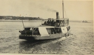
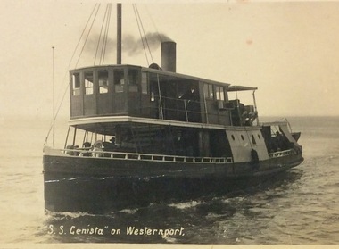
Photograph, Genista off from San Remo, ?
S.S. Genista - built 1886, Sydney. Western Port Ferry 1889 to early 1930's.S.S.Genista off from San Remo. View of stern - pier in background.local history, photographs, transport, shipping, maritime technology, boats, phillip island shipping, ferries, black & white photograph, phillip island, western port -
 Phillip Island and District Historical Society Inc.
Photograph, Genista's crew 1919, 1919
Group photo of the crew of S.S.Genista 1919 - shown in Fishing gear.Crew of S.S.Genista, 1919. Left to Right: Capt. Kerr, H.Kirkland, G.Kendall, McNeil, J.Jansson.local history, photographs, shipping, maritime technology, phillip island shipping, ferries, black & white photograph, phillip island, western port, ferry - genista, captain kerr, h. kirkland, g. kendall, mcneil, j. jansson -
 Phillip Island and District Historical Society Inc.
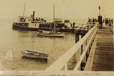
Photograph, Genista leaving Cowes jetty
Part of a collection of the "Rose & Valentine Series" Post Cards. M4915S.S. Genista leaving Cowes Jetty, Phillip Island. G. Walton's fishing boat in foreground. Small rowing boat near foreground.- Valentine series Post Card M4915Valentine series M4915local history, photographs, transport, shipping, maritime technology, boats, postcards, phillip island shipping, ferries, black & white photograph, phillip island, western port, ferry - genista -
 Phillip Island and District Historical Society Inc.
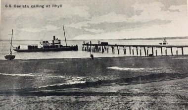
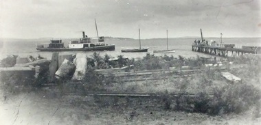
Photograph, Genista calling at Rhyll c1900, ?
S.S. Genista - built in 1886, Sydney. Western Port Ferry from 1889 to early 1930'sS.S. Genista calling at Rhyll - c.1900 Low tide, sand and mud in foreground.S.S. Genista calling at Rhylllocal history, photographs, transport, shipping, maritime technology, boats, phillip island shipping, ferries, black & white photograph, phillip island, western port, ferry - genista -
 Phillip Island and District Historical Society Inc.
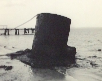
Photograph, Genista's boiler near Rhyll jetty 1966, 1966
Boiler of S.S. Genister being hauled from Channel near Rhyll Jetty 1966S.S.Genista's ship's Boiler with line attached floating - Jetty in background. 1966local history, photographs, transport, shipping, maritime technology, ferries, phillip island shipping, black & white photograph, phillip island, westernport bay, ferry - genista -
 Phillip Island and District Historical Society Inc.
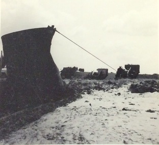
Photograph, Genista's boiler being landed 1966, 1966
Boiler of S.S. Genista being hauled from channel near rhyll Jetty 1966.Boiler of the S.S.Genista, line attached being landed.local history, photographs, transport, shipping, maritime technology, ferries, phillip island shipping, black & white photograph, phillip island, westernport bay, ferry - genista -
 Phillip Island and District Historical Society Inc.
Photograph, Genista approaching Rhyll c 1915, 1915?
"Genista" - built 1886, Sydney. Western Port Ferry 1889 to early 1930's. "Veronica" - built by J. Norling, 1913 at Bass Landing."Genista" approaching Rhyll jetty c.1915. Smaller black boat is John Norling's crayfishing boat - Veronica".local history, photography, photographs, transport, shipping, maritime technology, fisheries, ferries, fishing boats, black & white photograph, phillip island, western port -
 Phillip Island and District Historical Society Inc.
Photograph, Genista on Western Port
S.S.Genista - built 1886, Sydney. Western Port Ferry 1889 to early 1930's.S.S. Genista sailing on Western Port Bay.local history, photographs, transport, shipping, maritime technology, fisheries, ferries, black & white photograph, phillip island, western port