Showing 2558 items
matching aerial
-
 Bendigo Military Museum
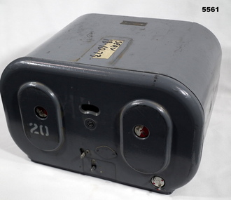
Magazine - MAGAZINE, FILM, Williamson Manufacturing Co Ltd
This photographic magazine attaches to the gear box universal ( see cat 4531). As an assembly, the type F22 aerial camera came into RAF and RAAF service c1942. It was used by the RAF over Europe and by the RAAF extensively through the Sth. West Pacific area of operations, during WW2. This type of camera was used through the Vietnam war up to the early 1980's. The F22 camera assembly when mounted in the reliable Canberra aircraft, did aerial survey work in PNG, Indonesia, Malaysia and Sumatra and the Australian mainland. This type of camera was used in Spitfires, Mosquitos, Avro Lincolns and Canberra aircraft.This is a heavy metal container painted in a grey colour. The label is on the top. One side has two enlarged oval sections. in those two ovals is one hole of 22 mm diameter. In those holes is a disc painted half red and half white. Below the ovals are two levers connected to the internal mechanism. Bottom RHS has a disc with 2 pins, red dots are printed on it. Nearly level with the top of ovals is a kidney shaped hole. In that hole is a rotating disc with graduations and numbers. the action side of magazine has a rectangular opening size 83/4" x 7/16". It is covered with a black soft material.Top has “serv 18-10-73” The number '20' has been stenciled on two surfaces.aerial photography, magazine, ww2, raaf -
 Bendigo Historical Society Inc.
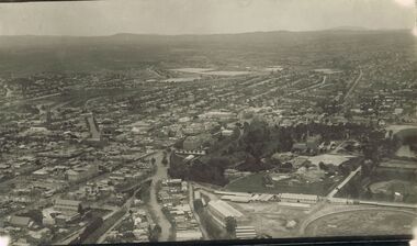
Photograph - AERIAL PHOTOGRAPH OF BENDIGO : 1928
Black and white aerial photograph of Bendigo, 1928. Bendigo Gaol and Rosalind Park in foreground, looking south. On reverse, partly cut off - View over Central B… (Shaw Ross Aviation C.. Printed in Glimpses o….. 1928 Carol Holsworth.bendigo, buildings, historic and archaeological -
 Bendigo Historical Society Inc.
Photograph - FORTUNA COLLECTION: AERIAL PHOTO FORTUNA 1945
Black and white photo of Fortuna area 1945. On bottom of image printed in black : ' Fortuna - Circa 1945, approximate Scale 1:1 400, Produced from aerial photography flown 1100 hrs 7th July 1945.' Image is very blurry. -
Tatura Irrigation & Wartime Camps Museum
Book, Girgarre Living History, Girgarre. Girgarre Living History, 2016
Girgarre - an extraordinary history, closer settlement, soldier settlement and family stories.Tells of the history of Girgarre, with information obtained from a collection of stories and extensive research into the Closer and Soldier Settlement of the districtRectangular shaped book ,aerial photo of the township and environs of Girgarre, on Market Day, September 2013. Photo extends over front & back covers, highly colourful cover. 251 pages. B/W photos and maps of local families and local scenes.girgarre, family histories, soldier settlement -
Tatura Irrigation & Wartime Camps Museum
Book, Girgarre Living History, Girgarre. Girgarre Living History, 2016
Girgarre - an extraordinary history, closer settlement, soldier settlement and family stories.Tells of the history of Girgarre, with information obtained from a collection of stories and extensive research into the Closer and Soldier Settlement of the districtRectangular shaped book ,aerial photo of the township and environs of Girgarre,on Market Day, September 2013. Photo extends over front & back covers, highly colourful cover. 251 pages ,B/W photos and maps of local families and local scenes.girgarre, family histories -
 City of Kingston
Photograph - Black and white, c. 1930
During the 1930s Moorabbin was an area with open grasslands, still often used for market gardening. The development of the city (and, later, suburb) can be seen emerging from the railway station.The Nepean Highway is a major highway running through the City of Kingston. This image is one of many that depicts its importance to the local community as it undergoes many changes over time.Black and white photograph of aerial view of intersection of Nepean Highway and South Road. Moorabbin Council Chambers are situated on the corner with the library, old shire building, Moorabbin railway station, St David's Anglican Church market gardens and open paddocks in the background.White round sticker on reverse with black printed text: 143 Handwritten in red ink on reverse: 156% / k000786moorabbin, council, railway station, railway, suburbs, paddocks, nepean highway -
Port Melbourne Historical & Preservation Society
Photograph - Photocopy, Aerial view over Swallow & Ariell and surrounds, 1950
Donor was researching property on the corner of Stokes and Graham St, as old timers claim it was "the Nelson Hotel" although there is no record of such in licensing records. Particular building is at upper left of this image.Large photocopy of an aerial photo. 1950 view over Swallow & Ariell and the Counting House shows St Joseph's Catholic Church; Methodist Church on Graham St (no longer there); Nott Street factories. The "Nelson Hotel" partially showing in the upper left corner.built environment - industrial, industry - food, swallow & ariell ltd, religion - anglican (holy trinity), religion - wesleyan methodist church, religion - roman catholic church (st josephs), nelson hotel, frederick thomas derham, built environment - domestic, business and traders - hotels -
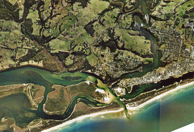 Lakes Entrance Historical Society
Photograph - Topography, 2007c
Colour aerial photograph of the land forms around the entrance to the Gippsland Lakes, from Kalimna West to Lakes Entrance, North Arm to the ocean. Shows massive sand buildup between Rigby Island and Kalimna, also Bullock Island. Lakes Entrance Victoriawaterways, navigation, topography -
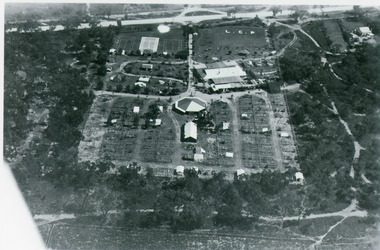 Lakes Entrance Historical Society
Photograph - Whiter's Camp Park, Bulmer H D, 1935
Black and white aerial view of Whiters Camp Park, looking south to Roadknight Street. Shows layout of camping facilities, including sites, tennis courts, rotunda, and family home which incorporated shop with all requirements for a holiday. Lakes Entrance Victoriatourism, resort, aerial photograph, camping -
 Glenelg Shire Council Cultural Collection
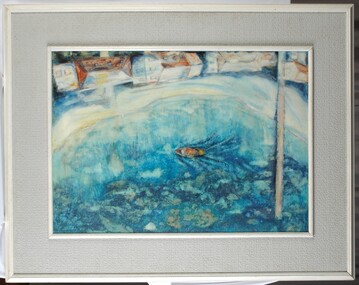
Painting, Summer Holiday, 1967
Aerial view of a harbour with a jetty and a boat. At edge of water is a narrow beach and 4 houses (white with roofs painted in orange, yellow, white and pale blue). Seaweed and reefs are visible below surface of water. Framed in wood and board frame (white and grey).Front: Barnard 1967 (lower left, blue paint). Back: Phyl Barnard "Summer Holiday" 1967. -
 Bendigo Historical Society Inc.
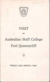
Programme - Australian Defence Industries (ADI) - Program for visit by Australian Staff College Fort Queenscliff, Friday 20th March 1981
Australian Defence Industries (ADI) - Program for visit by Australian Staff College Fort Queenscliff, Friday 20th March 198. Bifold introduction to the facilities at Ordinance Factory, Bendigo; with B&W aerial view of Ordinance Factory, Bendigo on back cover of the program.adi history, visitor introduction/program -
 Lakes Entrance Historical Society
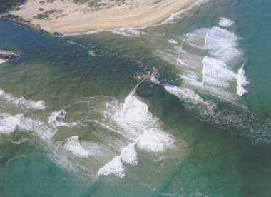
Photograph - Boat Harbour, Gippsland Ports, dredge April Hamer Lakes Entrance, 2006
Colour aerial photograph of the Entrance from Bass Strait to the Gippsland Lakes showing rock entrance groynes, surf on beach, dredge April Hamer working in the channel Lakes Entrance Victoria. Also another copy size 15 x 19.5 cmwaterways, topography, beaches, ocean -
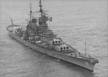 National Vietnam Veterans Museum (NVVM)
Photograph, Gibbons, Denis, USS New Jersey 1
Denis Gibbons (1937 – 2011) Trained with the Australian Army, before travelling to Vietnam in January 1966, Denis stayed with the 1st Australian Task Force in Nui Dat working as a photographer. For almost five years Gibbons toured with nine Australian infantry battalions, posting compelling war images from within many combat zones before being flown out in late November 1970 after sustaining injuries. The images held within the National Vietnam Veterans Museum make up the Gibbons Collection.A black and white photograph of the battleship USS New Jersey refurbished at a cost of US$27 million to engage targets, as far as thirty (30) miles inside North Vietnam. The New Jersey was recommisioned after President Nixon stopped the aerial bombing of the Northphotograph, tonkin gulf, president nixon, gibbons collection catalogue, uss new jersey, denis gibbons -
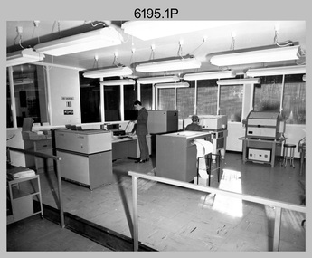 Bendigo Military Museum
Photograph - Aerotriangulation Production – Army Survey Regiment, Fortuna, Bendigo, c1979
This collection of 19 photos was most likely taken in 1979 in Air Survey Squadron. The PDP 11/70 minicomputer shown photos .2P to .3P was the operating system introduced in 1977 as the mainframe system for the control of the APC4, aerial triangulation block adjustments, SORA OP Analytical Orthophoto control, APR Analytical Terrain Profile Recorder computation, graphics, and general computing. The Zeiss (Jena) Stecometer analytic stereocomparator for air photography shown in photos .5P to .9P was introduced at Air Survey Squadron in 1963. Aerotriangulation production was expedited using computers for analytical photogrammetric processes. The technician accurately measured between pass, tie, and survey control points on aerial photographs. The OMI/Nistri AP/C-3 analytical plotter shown in photos .10P and .11P was introduced in 1972–1973. Photo .11P shows a coordinatorgraph attached to the AP/C-3. The Zeiss D2 Planimat Stereoplotter shown in photo .12P was used for analytical orthophoto control. Wild PUG4 point transfer devices shown in photos .17P to .19P were introduced in c1968 superseding the PUG2 devices. PUG4 devices were used by technicians to stereoscopically view the photography containing the survey control points and the mapping aerial photography. The Control points were transferred from the control photography to the mapping diapositives of aerial photography by drilling their locations into the photographic emulsion.This is a set of 19 photographs of Air Survey Squadron personnel operating aerotriangulation equipment at the Army Survey Regiment at Fortuna, Bendigo, c1979. Black and white photos are on photographic paper and were scanned at 300 dpi. They are part of the Army Survey Regiment’s Collection. .1) - Photo, black & white, c1979, Aerotriangulation tasks, unidentified technicians. .2) to .3) - Photo, black & white, c1979, PDP-11 minicomputers tasks, unidentified technician. .4) - Photo, black & white, c1979, Aerotriangulation tasks, unidentified technician. .5) - Photo, colour, c1979, Zeiss (Jena) Stecometer, unidentified technician. .6) to.9) - Photo, black & white, c1979, Zeiss (Jena) Stecometer, unidentified technician. .10) - Photo, black & white, c1984, OMI/Nistri APC/3-1 analytical stereoplotter, SPR Kristin (Isaac) Skidmore. .11) - Photo, colour, c1979, OMI/Nistri APC/3-1 analytical stereoplotter, unidentified technician. .12) - Photo, colour, c1979, Zeiss D2 Planimat Stereoplotter, unidentified technician. .13) - Photo, black & white, c1979, Aerotriangulation tasks, unidentified technician. .14) - Photo, black & white, c1979, Aerotriangulation tasks, unidentified technician. .15) - Photo, black & white, c1979, Aerotriangulation tasks, CPL Ken Talbot-Smith .16) - Photo, black & white, c1979, Aerotriangulation tasks, SPR David Jobe. .17) - Photo, black & white, c1979, Wild PUG4 point transfer device, WO2 Brian Mead. .18) - Photo, black & white, c1979, Wild PUG4 point transfer device, CPL Andy Wilson. .19) - Photo, black & white, c1979, Wild PUG4 point transfer device, unidentified technician..5P is annotated ‘OMI-Nistri AP/C Analytical Plotter’ and ’Topo 36’. .12P is annotated ‘Zeiss Jena Stecometer Stereocomparator’ and ’Topo 35’. There are no annotations on the other photos.royal australian survey corps, rasvy, army survey regiment, army svy regt, fortuna, asr, aerotrig, air survey -
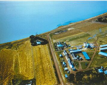 Lake Bolac & District Historical Society
Colour photograph, Lake Bolac Flax Mill, 1960
Aerial view of the Lake Bolac Flax Mill, circa 1960. Note the pump housing in front of Guy Rance's home, the polluted water entering the lake from the pipeline and the stooks of flax to the left of the road opposite the Mill.lake bolac, flax mill, 1960, rance -
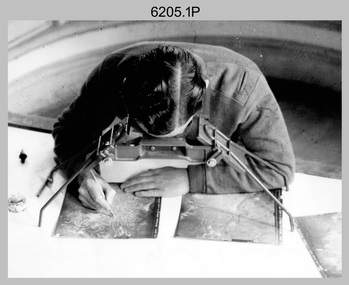 Bendigo Military Museum
Photograph - Stereoscopic Equipment – Army Survey Regiment, Fortuna, Bendigo
This is a set of six photographs of stereoscopic equipment and personnel at the Army Survey Regiment, Fortuna, Bendigo, c1950s to c1960s. The stereoscopes shown in photos .1P and .2P were used to stereoscopically view and interpret features in overlapping aerial photographs. The stereoscopic plotters shown in photos .3P and .4P were used to stereoscopically plot topographic detail from overlapping aerial photographs using a pantograph arm with pencil onto a controlled plotting sheet. The Ryker Model PL-3 Wernstedt-Mahan type stereoscopic plotter shown in photos .5P and .6P was used for precision contouring, planimetry and profiling. It was a comparatively simple stereoscopic mapping instrument designed to use ordinary contact prints of aerial photographs. It provides for plotting on a constant scale and approximate tilt correction but does not provide refinements such as correction for lens distortion. The plotter in Photo .6P does not have its pantograph arm attached. These plotters pre-date the Wild B9 and B8 stereo plotters introduced in the 1960s.This is a set of six photographs of stereoscopic equipment and personnel at the Army Survey Regiment, Fortuna, Bendigo, c1950s to c1960s. Black and white photos are on photographic paper and were scanned at 300 dpi. .1) - Photo, black & white, c1950s to c1960s, Universal Stereoscope, unidentified technician. .2) - Photo, black & white, c1950s to c1960s, Old Delft Scanning Stereoscopes, unidentified technicians. .3) - Photo, black & white, c1950s to c1960s, Unidentified stereoscopic plotters and technicians. .4) - Photo, black & white, c1950s to c1960s, Unidentified stereoscopic plotter, CPL Bill Shapcott. .5) and .6) - Photo, black & white, c1950s to c1960s, Ryker Model PL-3 stereoscopic plotter.Photo .4P is annotated on back - ‘Bill Shapcott (CPL)’royal australian survey corps, army svy regt, rasvy, army survey regiment, fortuna, asr, air survey, photogrammetry -
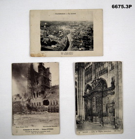 Bendigo Military Museum
Postcard - POSTCARDS WW1, PHOTOGRAPHIC, C.1914 - 1918
Postcard photos of locations in Northern France relating to Battlefields in WW1.1. B & W photo of aerial view town of Hazebrouck at time of WW1. 2. B & W photo of ruins of Cathedral in Ypres from WW1 called "Fire of the Belfrey". 3. B & W photo of the gate of Saint Oven Church in Rouen Church.1. Headed "Hazebrouck - Vue Generale" - on back is filled in Letter to "Louie". 2. Titled Campagne De 1914-15 - Ruines D' Ypres - Fire of Belfrey. 3. Titled "Rouen - Grille De I'Eglise Saint-Oven (Gate of St Oven Church).passchendaele barracks trust, postcards, france, ww1 -
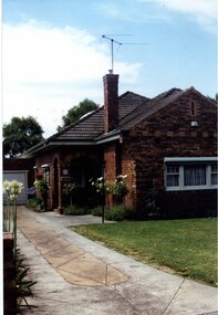 Glen Eira Historical Society
Photograph, Dalny Road, 15, Murrumbeena, 2001
Originally labelled "Beauville Estate, Established 1936, Still Thriving 65 years on, 10th March 2001", the Beauville Estate Album contains colour photographs of houses in the Estate. They were taken around the time of the Beauville Estate’s 65th Heritage Celebration held on 10/03/2001 and donated to the Caulfield Historical Society shortly afterwards. Photographer unknown. City of Glen Eira’s Heritage Management Plan Vol 2 p79 (this is p84 of the pdf version) – HO12 Beauville Estate and environs, Murrumbeena: The Beauville Historic Area is important at the State level as the first large housing estate undertaken by the AV Jennings Construction Co, later Jennings Group Limited, Victoria’s largest home builder. It is important also as a very early estate development incorporating a range of features other than houses and including made roads, shops and recreation facilities. In this respect it was the forerunner of the comprehensively planned housing estate of the post war era. The estate is distinguished by its aesthetic values, as is the earlier and comparable Hillcrest Estate, which are formed by a combination of restrained diversity in house styles, with the exception of no. 30 in the emerging International style, and by a landscaped garden environment. Colour photograph of an unpainted variegated brown brick house and garage with decorative brickwork. Other features include tiled roof, porch, tall feature chimney with a TV aerial attached, white-framed sash windows, awnings, white garage door and a concrete driveway.15murrumbeena, houses, architectural styles, 1930's, inter war style, a.v. jennings, av jennings, jennings, brick houses, beauville estate, dalny road, sir albert victor jennings, a v jennings construction co, beauville estate heritage area, glen eira city council, architectural features, jennings group limited, land subdivision, gardens, beauville historic area, brick features, garages (private), porches, arches, chimneys, sash windows, drives, awnings -
Bendigo Historical Society Inc.
Photograph - FORTUNA COLLECTION: AERIAL PHOTOGRAPH OF FORTUNA VILLA
Colour aerial photograph of Fortuna Villa, with Victoria Hill visible in background. Chum Street in foreground of image. Many cars parked in areas around Fortuna Villa, probably indicating that his photo was taken during the occupation of Fortuna by the Cartographic Division of the Department of Defence.bendigo, streetscape, fortuna -
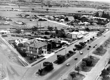
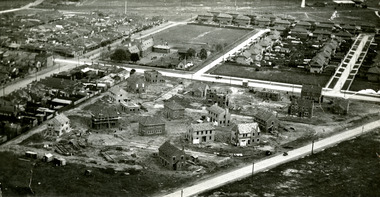 Port Melbourne Historical & Preservation Society
Photograph - Aerial view of houses during construction on Dunstan Estate, Port Melbourne, Department of Public Works, 1936
Twenty five (25) black and white or sepia photographs of the houses of the Dunstan Estate during their construction i.e. Griffin Crescent and Southward Avenue .04 - Aerial photographs (also shows Graham St School) Taken in 1936, some cars shown parked in streetsbuilt environment - domestic, domestic life, department of public works, dunstan estate, percy e everett, henry pye, albert dunstan -
Port Melbourne Historical & Preservation Society
Photograph - Aerial view of the mouth of the Yarra from Williamstown, 2006
B&W aerial photographic view of the mouth of the Yarra River, taken from above Williamstown and looking east. Greenwich Bay and the cooling water outlet for Newport Power Station in the foreground, the entrance and Webb Dock in the centre, Sandridge Beach and the city upper right.piers and wharves - webb dock, yarra river, garden city, fishermans bend, newport power station -
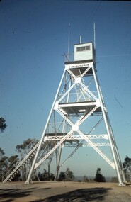 Bendigo Historical Society Inc.
Slide - PETER ELLIS COLLECTION: SLIDE, May 1970 - Jan 1972
Coloured slide transparency. Image is of a tall metal tower on top of a hill. The tower is white and a ladder is visible on the right hand side. There are two aerials and a wooden building on the top platform. The words Lookout Tower and One Tree Hill are handwritten on the top and bottom borders.Kodachrome Transparencyslide, bendigo, bendigo institute of technology -
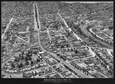 Ballarat Tramway Museum
Photograph - Black & White copy, Charles Pratt, "Ballarat looking west ca 1925-40"
Original photograph by Charles Daniel Pratt, with the original image held by the State Library of Victoria. Edited by Richard Conn. Purchased by the Museum.Provides information about the appearance of Ballarat East and views across over the Railway Station to Lake Wendouree and along along Sturt St. Shows the nature of the Bridge St shopping centre and other places.Black & White copy photograph aerial view A4 size, titled "Ballarat looking west ca 1925-40" - looking along Sturt St with the Railway yards, Bridge St and Victoria St in the view. Some trams can be seen at Grenville St.ballarat, aerial photo, sturt st, victoria st -
University of Melbourne, Burnley Campus Archives
Plan, Wilsons Promontory8119-I and Glennie 8119-IV, 1971
State Aerial Survey Plan of Wilsons Promontory and Glennie. Dated 1971. Provisional Compilation of Sheets 8119-I and 8119-IV from Commonwealth Department of National Development Photography for the Department of Crown Lands and Survey Victoria. Students made excursions to Wilsons Promontory.wilsons promontory, glennie group, anser group, bass strait, aerial survey -
 Eltham District Historical Society Inc
Photograph - Aerial Photograph, Landata, Eltham / Research, Vic, Jan. 1951
Centred on Brinkkotter Road opposite Yarramie Reserve, Eltham bounded by Maroondah Aqueduct to north, Nyora Road to south, Eltham College to east and Leane Drive to west. Historic Aerial Imagery Source: Landata.vic.gov.au Aerial Photo Details: Project No :65 Project : MELBOURNE AND METROPOLITAN PROJECT NO. 2 Run : 7 Frame : 8 Date : 01/1951 Film Type : B/W Camera : EAG9 Flying Height : 12200 Scale : 12000 Film Number : 1419 GDA2020 : 37°42'32"S, 145°10'41"E MGA2020 : 339408, 5824924 (55) Melways : 22 F3 (ed. 42)Historical aerial photos and photo maps provide viusal evidence of the chronology of changes to the built landscape of the district and assist in dating other imagesaerial photo, 1951-01, eltham, neil webster collection, brinkkotter road, eltham college, leane drive, maroondah aqueduct, melways 22f3, nyora road, yarramie reserve -
 Eltham District Historical Society Inc
Photograph - Aerial Photograph, Landata, Eltham, Vic, Jan. 1951
Centred on Beard Street between Main Road and Frank Street, Eltham bounded by Maroondah Aqueduct to north, Arthur Street to south, Maroong Drive to east and Catholic Ladies College to west. Historic Aerial Imagery Source: Landata.vic.gov.au Aerial Photo Details: Project No :65 Project : MELBOURNE AND METROPOLITAN PROJECT NO. 2 Run : 7 Frame : 9 Date : 01/1951 Film Type : B/W Camera : EAG9 Flying Height : 12200 Scale : 12000 Film Number : 1419 GDA2020 : 37°42'23"S, 145°09'39"E MGA2020 : 337874, 5825170 (55) Melways : 22 B3 (ed. 42)Historical aerial photos and photo maps provide viusal evidence of the chronology of changes to the built landscape of the district and assist in dating other imagesaerial photo, 1951-01, eltham, neil webster collection, arthur street, beard street, catholic ladies college, frank street, main road, maroondah aqueduct, maroong drive, melway 22b3, research (vic.) -
 Eltham District Historical Society Inc
Photograph - Aerial Photograph, Landata, Eltham North, Feb. 1956
Centred on present day 54 Kelway Crescent, Eltham North bounded by Glen Gully Road to north, Meruka Drive to south, Eltham College to east and Leach Street to west. Historic Aerial Imagery Source: Landata.vic.gov.au Aerial Photo Details: Project No :250 Project : MELBOURNE OUTER SUBURBS PROJECT Run : 17 Frame : 113 Date : 02/1956 Film Type : B/W Camera : EAG9 Flying Height : 10000 Scale : 12000 Film Number : 1176 GDA2020 : 37°42'16"S, 145°08'08"E MGA2020 : 335650, 5825336 (55) Melways : 21 G2 (ed. 42)aerial photo, 1956-02, eltham, eltham north, glen gully road, leach street, main road, melway 21g2, meruka drive, montmorency, neil webster collection -
 Eltham District Historical Society Inc
Photograph - Aerial Photograph, Landata, Montmorency, Feb. 1956
Centred on present day Tahlee Place Reserve and Sherbourne Preschool, Montmorency bounded by Progress Road to north, Withers Way to south, Main Road to east and Leach Street to west. Historic Aerial Imagery Source: Landata.vic.gov.au Aerial Photo Details: Project No :250 Project : MELBOURNE OUTER SUBURBS PROJECT Run : 17 Frame : 114 Date : 02/1956 Film Type : B/W Camera : EAG9 Flying Height : 10000 Scale : 12000 Film Number : 1176 GDA2020 : 37°42'50"S, 145°08'02"E MGA2020 : 335512, 5824286 (55) Melways : 21 F5 (ed. 42)aerial photo, 1956-02, neil webster collection, central park, eltham, leach street, main road, melway 21f5, montmorency, progress road, withers way, sherbourne preschool, tahlee place reserve -
 Eltham District Historical Society Inc
Photograph - Aerial Photograph, Landata, Lower Plenty, Feb. 1956
Centred on present day 217 Old Eltham Road, Lower Plenty bounded by Pitt Street to north, Yarra River to south, Main Road to east and Bonds Road to west. Historic Aerial Imagery Source: Landata.vic.gov.au Aerial Photo Details: Project No :250 Project : MELBOURNE OUTER SUBURBS PROJECT Run : 17 Frame : 116 Date : 02/1956 Film Type : B/W Camera : EAG9 Flying Height : 10000 Scale : 12000 Film Number : 1176 GDA2020 : 37°43'58"S, 145°07'49"E MGA2020 : 335237, 5822186 (55) Melways : 21 E10 (ed. 42)aerial photo, 1956-02, neil webster collection, eltham, main road, bonds road, elham, lower plenty, melway 21e10, pitt street, yarra river -
 Eltham District Historical Society Inc
Photograph - Aerial Photograph, Landata, Eltham, Feb. 1956
Centred on present day Shalbury Avenue, Eltham bounded by Leane Drive and Parsons Road to north, Nyora Road to south, Reynolds Road to east and the Diamond Creek to west Historic Aerial Imagery Source: Landata.vic.gov.au Aerial Photo Details: Project No :250 Project : MELBOURNE OUTER SUBURBS PROJECT Run : 18 Frame : 95 Date : 02/1956 Film Type : B/W Camera : EAG9 Flying Height : 10000 Scale : 12000 Film Number : 1176 GDA2020 : 37°41'57"S, 145°09'51"E MGA2020 : 338145, 5825965 (55) Melways : 22 C1 (ed. 42)aerial photo, 1956-02, neil webster collection, eltham, diamond creek (creek), melway 22c1, nyora road, parsons road, reynolds road, shalbury avenue