Showing 1531 items matching "high street road"
-
![Map, Plan showing proposed deviation of the road through McKenzie's Flat to Bacchus Marsh. [Undated]](/media/collectors/5e461d8021ea67224c82f2a1/items/677d22f37f2053f3e5d500dc/item-media/677d25247f2053f3e5d50950/item-fit-380x285.jpg) Bacchus Marsh & District Historical Society
Bacchus Marsh & District Historical SocietyMap, Plan showing proposed deviation of the road through McKenzie's Flat to Bacchus Marsh. [Undated]
The date of this map or plan is uncertain. McKenzie's Flat is a bushland picnic area on the Lerderderg River in the Lerderderg State Park close to Bacchus Marsh. The proposed road deviation shown on this map is very close to a sharp bend in the Lerderderg River which shows an island in the centre of that bend. The name of a landholder, J.B. Perry is shown on the map close to the area of the road deviation.The land shown is identified as within the Parish of Merrimu.Single page map showing a proposed deviation of the road from McKenzie's Flat to Bacchus Marsh. Scale: 5 chains to 1 inch. Part of a set of maps which are pasted into a bound volume containing 76 maps or plans in total. High resolution digital image stored on BMDHS computer network. mckenzies flat bacchus marsh, bacchus marsh roads and streets -
 Flagstaff Hill Maritime Museum and Village
Flyer - Advertisement, Soap, Wright, Layman & Umney Ltd, Late 1940s
Wright’s Coal Tar Soap was a popular brand of household soap, manufactured by William Valentine Wright from 1867. The yellow soap was antiseptic, designed to cleanse the skin thoroughly. It was originally named Sapo Carbonis Detergens, which remains a registered trademark. The product was developed from ‘liquor carbonis detergens’, the liquid by-product of the distillation of coal to make coke. The liquid was made into an antiseptic soap for treating skin diseases. William Valentine Wright was born in 1826 at Aldeburgh, Suffolk. He was a wholesale druggist and chemist who had a small business, W.V. Wright & Co., at 11 Old Fish Street Hill, City of London, where he first sold the soap. In 1863 Wright moved his firm to small premises at 50 Southwark Street, Southwark, London, and not long afterwards M. Sellers and Mr Charles Noel Layman joined the partnership. The company's name changed to Wright, Layman & Umney, when Charles Umney (1843–1909) was taken into the partnership on June 17, 1876, after the death of M. Sellers. William Valentine Wight 1877. Rob Umney, great-great-grandson of Charles Umney, provided further details about the firm, adding that in the late 1960s, the Wright’s Coal Tar Soap business was taken over by LRC Products Ltd who sold it to Smith & Nephew in 1994. The current owners of the brand, Simple Health and Beauty Ltd are based in Solihull and the soap is called Wright's Traditional Soap ‘With coal tar fragrance’. The coal tar has been replaced with tea tree oil. There were concerns that ingredients in coal tar could cause cancer when a person is exposed to very high concentrations, such as in roofing and road paving. In January 2025 the current manufacturers still produce the Wright's Coal Tar Soap.The flier states that Wright's Coal Tar Soap was sold throughout the United Kingdom and Colonies, which includes Australia. The soap is representative of the many consumer goods sold at pharmacies and chemist shops across the world, such as Sambell and Son, who operated a pharmacy in Fairy Street, Warrnambool in the 19th century. The paper flier is rectangular and has printed text and a logo. The top right corner has stamped punch marks. It promotes Wright's Coal Tar Soap, made by Wright, Layman & Umney Ltd. England.Punch mark; "1176"flagstaff hill, maritime museum, wright's, coal tar soap, soap, bathing, antiseptic, washing, personal hygiene, london, southwark, chemist, pharmacist, colonies, wright's coal tar soap, sapo carboni detergens, punch marks, england, soap tablet, babies soap, nursery soap, advertising, poster, flyer, wright, layman & umney ltd., w.t. wrifght & co., soap bar, soap cake -
 Flagstaff Hill Maritime Museum and Village
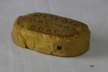
Domestic object - Soap, Wright, Layman & Umney Ltd, ca 20th century
Wright’s Coal Tar Soap was a popular brand of household soap, manufactured by William Valentine Wright from 1867. The oval yellow soap tablet was antiseptic, designed to cleanse the skin thoroughly. It was originally named Sapo Carbonis Detergens, which remains a registered trademark. The product was developed from ‘liquor carbonis detergens’, the liquid by-product of the distillation of coal to make coke. The liquid was made into an antiseptic soap for treating skin diseases. William Valentine Wright was born in 1826 at Aldeburgh, Suffolk. He was a wholesale druggist and chemist who had a small business, W.V. Wright & Co., at 11 Old Fish Street Hill, City of London, where he first sold the soap. In 1863 Wright moved his firm to small premises at 50 Southwark Street, Southwark, London, and not long afterwards M. Sellers and Mr Charles Noel Layman joined the partnership. The company's name changed to Wright, Layman & Umney, when Charles Umney (1843–1909) was taken into the partnership on June 17, 1876, after the death of M. Sellers. William Valentine Wight 1877. Rob Umney, great-great-grandson of Charles Umney, provided further details about the firm, adding that in the late 1960s, the Wright’s Coal Tar Soap business was taken over by LRC Products Ltd who sold it to Smith & Nephew in 1994. The current owners of the brand, Simple Health and Beauty Ltd are based in Solihull and the soap is called Wright's Traditional Soap ‘With coal tar fragrance’. The coal tar has been replaced with tea tree oil. There were concerns that ingredients in coal tar could cause cancer when a person is exposed to very high concentrations, such as in roofing and road paving. In January 2025 the current manufacturers still produce the Wright's Coal Tar Soap.Wright's Coal Tar Soap was sold throughout the United Kingdom and Colonies, which includes Australia. The soap represents many consumer goods sold at pharmacies and chemist shops across the world, such as Sambell and Son, who operated a pharmacy in Fairy Street, Warrnambool in the 19th century. The product has endured for over 150 years.Soap; yellow oval tablet of soap engraved with the brand Wright's Coal Tar oval."WRIGHT'S / COAL TAR / SOAP"flagstaff hill, maritime museum, wright's, coal tar soap, soap, bathing, antiseptic, washing, personal hygiene, london, southwark, chemist, pharmacist, colonies, wright's coal tar soap, sapo carboni detergens, england, soap tablet, babies soap, nursery soap, wright, layman & umney ltd., w.t. wrifght & co., soap cake, soap bar, medical, cleansing, baby care -
 Bendigo Historical Society Inc.
Financial record - Invoices 1892 - 1902, 31/01/2017
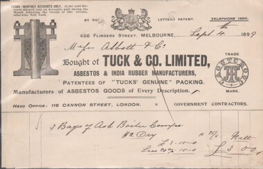
8545a Docket from Tuck & Co. Limited, Asbestos & India Rubber Manufacturers, 4566 Collins Street, Melbourne; Sept. 4th, 1889; Head Office: 116 Cannon Street, London. Purchased 3 Bags of Asb. Boiler ?? at a cost of £3/- by Messrs. Abbitt & Co. 8545b Docket from G. Wood, General Founder, Kensington Iron Foundry, Macauley Road, dated Dec. 2nd, 1896; due from Mr. J. H. Abbott, For 1 doz. combination parts& 1/2 doz. stands for parts at £1/14/00. 8545c Memorandum James Oppy, Boot and Shoemaker, Fitzroy Street, Kerang, dated Aug. 23rd, 1893. Apology and advice the amount owing will be forwarded on 1st of next month (Sept.). 8545d Docket for six items purchased by Messrs. J.H. Abbott, Bendigo for £63/16/00 from The Australian Explosives & Chemical Coy. Ltd on Aug. 5, 1902. Manufacturers and Importers of High Explosives and Detonators, 356 Little Collins Street, Melbourne 8545e Docket / quote from J. Kennon & Sons, Tanners, Curriers & Leather Merchants, 206 Bridge Road, Richmond. October 19th, 1888, quotation sent to Mr. J H Abbott, Leather Merchant, Sandhurst.bendigo businesses, j. kennon and sons, tuck and co, g. wood, james oppy, the australian and chemical coy -
![Map, Liquidator's sale, 1896. [Woolpack Estate, Bacchus Marsh]](/media/collectors/5e461d8021ea67224c82f2a1/items/6779ee97032b72846b5995f2/item-media/6779ef33032b72846b599b30/item-fit-380x285.jpg) Bacchus Marsh & District Historical Society
Bacchus Marsh & District Historical SocietyMap, Liquidator's sale, 1896. [Woolpack Estate, Bacchus Marsh]
The Woolpack Estate was an area of land owned by various landowners in the Bacchus Marsh area since the early Colonial period of the 1840s. The area was located on the eastern side of the Bacchus Marsh township about 7 kilometers from the town. The Lerderderg River ran through part of the land and so did the Melbourne to Ballarat Road. The historic Woolpack Inn associated with James Crook was also located on this land. By 1896 150 acres of this land was under the control of liquidators for the Federal Bank of Australasia who instructed that the land be sub-divided and sold in lots by public auction. A successful sale was held on 24 June 1896. Most of the blocks of land were sold for higher than expected prices and most of the buyers were people from the town and district of Bacchus Marsh. The map includes various details about the land which is described on the map as an "important sale of rich alluvial irrigable flat land in the Bacchus Marsh Valley, and other properties". The auction was conducted by the local agents W. Anderson and Bence in conjunction with Pearce Brothers also of Bacchus Marsh.A single page paper map showing a plan of 150 acres of land from the Woolpack Estate to be sold in various lots in June 1896. Also shown on the map are lots for sale at Robinson's Farm on Coimadai Creek and allotments near Bacchus Marsh railway station, including lots on Government Road (East Maddingley Road), View Street and Government Road (Parwan Road). No scale provided. The map is pasted into a bound volume containing 76 maps or plans in total. High resolution digital image stored on BMDHS computer network. land sales bacchus marsh, bacchus marsh victoria maps, woolpack estate bacchus marsh victoria -
 Charlton Golden Grains Museum Inc
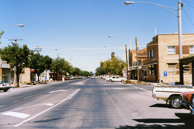
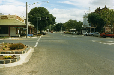
Photograph, Charlton High St 1987, c.1987
High St Charlton 1987. Part of Shire of Charlton series of photos. National Australia Bank building. Established as Bank of Victoria in 1876, later became Commercial Banking Company of Sydney. Current building built in c. 1940Colour photo of High St, Charlton looking east. National Australia Bank on the corner of High & Armstrong Streets. Sign for Victoria Bitter and East Charlton Hotel on LH side. White car travelling toward photographer. Two people holding bicycles and standing next to a motor bike on LH side of road.high st charlton, national australia bank, bank of victoria, commercial banking company of sydney, charlton, business, industry -
 Charlton Golden Grains Museum Inc
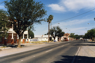
Photograph, High St Charlton, east end, southside c. 1987, c.1987
Cricket Club Hotel established 1875, rebuilt as a two storey building 1935. Photograph part of the Shire of Charlton streetscape 1987Colour photograph looking west along High St. Cricket Club Hotel on the other side of the road with a large tree in front of the building. Blue and white signage for Steve Hill Ford further along with two palm trees at the front. Cars parked along both sides of the street. A person riding a bike toward the photographer.cricket club hotel, high st charlton, charlton, business, industry -
 Charlton Golden Grains Museum Inc
Photograph, Pollard, Jenny, High Street Charlton 1989, c.1989
... at the end of the road. High Street Charlton 1989 Photograph ...High Street Charlton streetscape. Shows Sweatman's North Central Panel Beaters (formerly Charlton Motors Pty Ltd garage), Heather's Choice Gift Shop (in the former Bilton/Dillon building built 1889), Westpac Bank, War Memorial (built 1923)Colour photograph of High St Charlton taken near the corner of Armstrong Street looking west. Garden beds in lower LH, road signs pointing to St Arnaud and to Mildura and Donald. North Central Panel Beaters on corner. Orange car driving west, person crossing the road, man standing near white ute in front of Westpac bank on RH side of photo. Heather's Choice sign on side of building. War Memorial at the end of the road.sweatmans, north central panel beaters, heather's gift shop, bilton building, westpac, war memorial, charlton, business, industry -
 Bacchus Marsh & District Historical Society
Map, Main Road and Gell Street Allotments
This map shows allotments of land along Gell Street Bacchus Marsh running between Main Road (now called Main Street) and Lerderderg Street. The total area of the map encompasses Main Road, Church Street, Lerderderg Street and Gell Street. 36 allotments of land are shown. Three allotments which connect to Main Road are shaded in pink. The date of the map has not been established but the National Bank building erected in 1865 near the Border Inn is indicated which indicates that the map dates from after 1865. Reports in the Bacchus Marsh Express newspaper on 5 March 1870, page 2, column 6 announced building lots in Gell Street had been withdrawn from sale by the agent J.E. Crook. Later reports in the Express on 1 November 1873, page 2, column 2 advertised 14 allotments of land in Gell Street for sale. Single page map showing allotments of land along the Main Road (Main Street) and Gell Street areas of Bacchus Marsh. Part of a set of maps which are pasted into a bound volume containing 76 maps or plans in total. High resolution digital image stored on BMDHS computer network. bacchus marsh victoria maps, gell street land allotments, main street land allotments -
 Bacchus Marsh & District Historical Society
Map, Gaynor Street Area Land Sales, Maddingley, 1888
This map was produced for a major sale of land in the Maddingley area of Bacchus Marsh in 1888. The sale was conducted by two firms from Melbourne, Carney and Kelly 12 Swanston Street Melbourne. and 'Richardson, Kerr & Co. 40 Flinders Lane Melbourne. 136 blocks were for sale.A single page paper map showing land allotments for sale in the Maddingley area of Bacchus Marsh. Locations shown include Gaynor Street, Maddingley Road South, Parwan Road, Mitchem Street, Typpynge Street, Finn Street and East Maddingley Road. . The map is pasted into a bound volume containing 76 maps or plans in total. High resolution digital image stored on BMDHS computer network. bacchus marsh victoria maps, maddingley victoria maps, land use, maddingley victoria history, land sales bacchus marsh, land sales maddingley -
 Bacchus Marsh & District Historical Society
Map, Gaynor Street Land Sales, Maddingley, circa 1880s-1890s
This map was produced for a major sale of land in the Maddingley area of Bacchus Marsh. The precise date of the sale has not been determined. Features present on the map such as the Bacchus Marsh Railway Station indicate the land sale must have taken place some time after 1887 when the Railway Station opened. A single page paper map showing land allotments for sale in the Maddingley area of Bacchus Marsh. Locations shown include Gaynor Street, Maddingley Road South, Parwan Road, Mitchem Street, Typpynge Street, Finn Street and East Maddingley Road. . The map is pasted into a bound volume containing 76 maps or plans in total. High resolution digital image stored on BMDHS computer network. bacchus marsh victoria maps, maddingley victoria maps, land use, maddingley victoria history, land sales bacchus marsh, land sales maddingley -
 Bacchus Marsh & District Historical Society
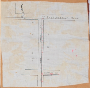
Map, Lord Street, Bacchus Marsh. Undated
A small single page map showing the line of Lord Street Bacchus Marsh between Ballarat Road (Main Street) and Simpson Street. Part of a set of maps which are pasted into a bound volume containing 76 maps or plans in total. High resolution digital image stored on BMDHS computer network. bacchus marsh victoria maps, lord street bacchus marsh maps -
 Bacchus Marsh & District Historical Society
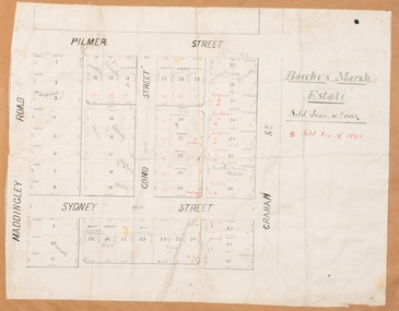
Map, Bacchus Marsh Estate sold 30th June 1888 and sold 28 December 1895
Blocks of land in this area of Bacchus Marsh were sold in lots between 1888 and the late 1890s. This map shows sales made in 1888 and 1895.Single page map showing allotments of land bounded by Pilmer Street, Graham Street, Sydney Street and Maddingley Road (Grant Street) in Bacchus Marsh.The area is dissected by Como Street down the central area. 43 blocks of land are shown with the names of buyers or sellers in 1888 written in black in. Buyers or sellers for December 1895 are written in red ink. Part of a set of maps which are pasted into a bound volume containing 76 maps or plans in total. High resolution digital image stored on BMDHS computer network. bacchus marsh victoria maps, land sales bacchus marsh, pilmer street bacchus marsh, graham street bacchus marsh, sydney street bacchus marsh, como street bacchus marsh, maddingley road bacchus marsh, grant street bacchus marsh -
 Linton Mechanics Institute and Free Library Collection
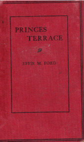
Book - Novel, Ford, Effie Marie, Princes Terrace, 1934
272 p. : Red cover with black text.fictionfiction, effie marie ford -
 Ringwood and District Historical Society
Document - Folder, Land Sale - Monterey Park Subdivision, Warrandyte Road, Ringwood North, Vic. - 1981
Foolscap manilla folder containing double-sided flyer advertising residential subdivision development, including outline of local facilities and services, with locality map and layout of Monterey Park streets. Subdivision includes Parkwood High School, Tortice Drive, Heape Way, Appleberry Place, Stringybark Court, Conifer Court, Crawley Grove, Monterey Close (later Monterey Place), Lucy Place, Middlebrook Drive, Gahnia Close, Glanfield Court, Cone Close, Jull Parade, Pinus Close (later Pinetree Court), Radiata Close, Old Warrandyte Road, and entry from Warrandyte Road. Vendor - Jennings Industries Limited, 690 Springvale Road, Mulgrave, 3170, Phone 5618000. A4 enclosures with tables showing each allotment List Price, Builders Price, Cash Price and Terms Price. Information page headed "Form of Restrictive Covenant to be incorporated in Transfer" specific to Certificates of Title. Restrictive Covenant (summary): (Name/s) "... will not erect or construct or cause to be erected or constructed on the land hereby transferred (a) Any front boundary fence, other than a fence which does not exceed one metre in height unless the same is set back as least 1.5 metres from the front boundary and the same is effectively screened from that boundary by the planting of trees, shrubs or plants. (b) Any side boundary fence other than a fence which is set back at least 1.5 metres from the front boundary on which does not exceed 1 metre in height within 1.5 metres of the front boundary. (c) For a period of 5 years from the date hereof, any building on the said land unless and until the Plans and Specifications thereof have first been approved by the said Residential Developments Pty. Limited. (d) For a period of 2 years from the date hereof whilst the said land remains vacant any Signboard or Notice advertising the sale of the said lot or any other lot. These covenants shall appear on the Certificate of Title to issue for the said land and run with the land." -
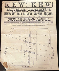 Kew Historical Society Inc
Plan, Kew! Kew!, 1888
... High Street), Gladstone Street (now Campbell Street?), Park... by Bulleen Road (now High Street), Gladstone Street (now Campbell ...The Land Boom of the 1880s accelerated the rate of subdivisions in Kew. This subdivision, 'Kew! Kew!' was also impacted by, or resulted from, the decision by the Victorian Government to construct the Outer Circle railway. Construction of the railway began in 1888 and was completed in 1891. Plan of an 1888 subdivision bounded by Bulleen Road (now High Street), Gladstone Street (now Campbell Street?), Park Street (now Adeney Avenue), and Belmore Road (now Harp Road). The 16 lots in the proposed subdivision are bisected by the route of the Outer Circle railway, and next to the proposed Normanby Station (later renamed East Kew). On the plan, local landmarks such as the tram terminus, the Harp of Erin hotel, and the station are located. The street where the lots are numbered , was called Welsh Street on the plan as this was the name of the vendor. Surrounding land owners are also named: G. Smith Esq, Matthew Maher Esq, and Maurice Neligan Esq.outer circle railway, land subdivisions -
 Melbourne Tram Museum
Photograph - PCC 1041 at cnr Miller St and Plenty Rd
The photograph shows PCC 1041 at corner of Miller Street and Plenty Road, Northcote displaying destination 'East Preston" Route 88.Yields information about this prototype's limited period in service.Colour photograph, no notestrams, pcc 1041, route 88, miller st, tramways, pcc class, plenty rd, high st, northcote -
 Sunbury Family History and Heritage Society Inc.
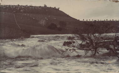
Photograph, Jacksons Creek
The photograph of the waterfall tumbling over rocks in the Jacksons Creek are a feature downstream from the Macedon Street bridge and Craiglee when the there has been high rainfall. The steep escarpment on the LHS leads to Jacksons Hill and the line of trees in the distance are growing along Macedon Street (Sunbury Road).After heavy rainfall, Jacksons Creek rises suddenly and small trickles over the rocky outcrops become fast flowing waterfalls.A non-digital sepia photograph backed onto thick cardboard of a waterfall tumbling over rocks in a river with a high escarpment rising up from the watercourse. There are rocky outcrops across the hillside with a pipe down the hillside. jacksons creek, jackson hill, waterfalls, rivers -
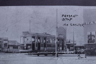 Melbourne Tram Museum
Slide - Black and white reproduction photograph - K class tram 92, mid 1920s
... of the MMTB and methods of seeking a tram stop shelter and High Street ...Photograph - of a K class four-wheel or single truck tram on a PMTT route 14 (STRATHALBYN ST (Kew) - VICTORIA BRIDGE) tram service, at Harp Road and High St. The reference gives the tram based at Kew Depot in 1928. The tram was originally a Prahran and Malvern Tramways Trust tram, though, by the time of this photograph, it has been re-lettered for the MMTB, which took over the PMTT in 1920. The photograph has been marked up for a submission possibly to either Council or the MMTB for a waiting room or shelter at this location. The wall of the Harp of Erin Hotel and a Victoria Bitter sign can be seen on the right-hand side. The original photo appears to have been torn. Original photo mid to late 1920's.Yields information about the K class tram of the MMTB and methods of seeking a tram stop shelter and High Street and Harp Road intersection.Kodachrome cardboard duplicate slide - Black and white reproduction photograph - K class tram 92 - at Harp Road Kew "MP17" in penciltrams, tramways, kew, harp road, route 14, k class tram, tram 92, harp of erin, victoria bitter, high st, strathalbyn st -
 Melbourne Tram Museum
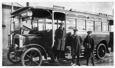
Photograph - Black and White - MMTB Bus No. 16
MMTB bus No. 16, Thornycroft J chassis, body by James Motors. For details of the chassis see MMTB Drawing R1912, Has the driver, an Inspector and Conductor standing alongside the bus on the Melbourne to Elsternwick via High Street route. Note the solid tyres and the small windscreen providing some limited protection to the driver. Yields information about the second MMTB Thorncroft buses.Black and white photograph of the MMTB No. 16 with an Inspector and crew. Smaller print held as well.tramways, buses, mmtb, thornycroft, crews, inspectors -
 Melbourne Tram Museum
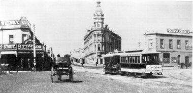
Photograph - Black and White - St Kilda Junction c1900
... Photo looks south along High Street from St Kilda Junction ...Photo looks south along High Street from St Kilda Junction with Wellington St on the left, Barkly St and Fitzroy St on the right. Has the Licencsed Grocer of R T Taylor, the Junction Hotel and Corner Hotel with a Fosters Lager Beer advertisement. The cable tram is on a St Kilda to Queensberry St service. Saloon car No. 69Yields information about St Kilda Junction c1900Photograph - Black and White - St Kilda Junction c1900.tramways, trams, cable cars, st kilda road, st kilda junction, high street, barkly street, junction hotel, corner hotel, tram 69 -
 Melbourne Tram Museum
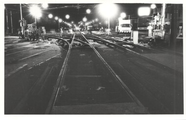
Photograph - Trackwork High St St Kilda, Keith Kings, 17-3-1974
... or junction at High St and Brighton Road at Carlisle St St Kilda 17/3.... The work was part of the major road widening project of High Street ...Photo shows the installation of new special work or junction at High St and Brighton Road at Carlisle St St Kilda 17/3/1974. The work was part of the major road widening project of High Street between St Kilda Junction and Carlisle St with the trams relocated into their own reservation. The track was raised 18 inches or about 450mm above the previous road level. The track was brought into use on Monday 18/3/1974.Yields information about the installation of a new junction in 1974 and the methods used.Photograph - Trackwork High St St KildaDetailed description on rear. K S Kings stamp and photo number 130-20. tramways, high st, carlisle st, trackwork, brighton road, junctions -
 Linton and District Historical Society Inc
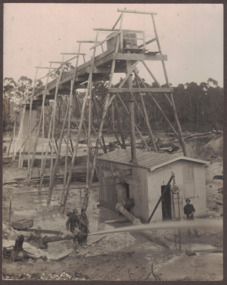
Photograph, Electro Hydraulic Dredge, Snake Valley, 1909
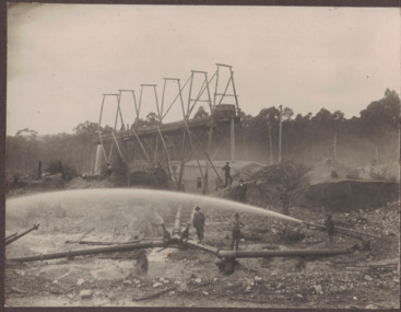
Electro hydraulic dredge Snake Valley 1909. J Mc Bennett, was an engineer back at the main base, at Dawson's dam on the Carngham Road, Between Linton and Snake Valley. These dredges were used for getting gold. The streams of water under high pressure just washed the hills and ground away. This dredge closed down early 1910. 200 H.P. motors were used and 10 in. pumps.Black and white image of three workmen, one beside mining building the other two at dredge pump outlet. Image mounted on dark brown card. Between 1904 and 1911 the Electro Hydraulic Company sought to extract gold in an area north of Linton known as the Hard Hills. By blasting water from high-pressure hoses into the hillsides, soil containing gold was washed out for sluicing. Two gravel pumps in Dawson's Dam pumped the wash through the sluices. Despite considerable investment in expensive equipment, the Company did not have a great deal of success, and the mining operation ceased in 1911.mining, gold, mining equipment, electro hydraulic dredge, dredging, sluicing, dawson's dam, snake valley, miners -
 Linton and District Historical Society Inc
Photograph, Electro Hydraulic Dredge, Snake Valley, 1909
Black and white image of workmen at electro hydraulic dredge Snake Valley mine site. Image has been mounted on dark brown card. Electro hydraulic dredge Snake Valley Victoria 1909. J.M.C. Bennett was an engineer back at the main base, at Dawson's Dam on the Carngham Road, bet Linton and Snake Valley. These dredges were used for getting gold. The streams of water under high pressure just washed the hills and ground away. This dredge closed down early 1910. 200 H.P. Motors were used and 10 in. pumps.electro hydraulic dredge, dredging, sluicing, mining, gold, miners, mining equipment, snake valley -
 Melbourne Tram Museum
Album - Charles Craig - part 2 of 2, 1950s to 1970s
Photo - see pdf file for further information. Number Brief Description CC271 Y1 610 and another at Camberwell depot CC272 Ditto CC273 Y1 613 at Batman Ave CC274 Y1 611 Peel St North Melbourne CC275 Y 469 Camberwell depot CC276 Ditto CC277 Postcard – L104 – MMTB CC278 L103, Hawthorn Road CC279 L103, Hawthorn Road CC280 L103 Dandenong Road CC281 L103 and w5 847 Dandenong Road CC282 L104 on Preston Workshops traverser CC283 Flinders St station with Ws CC284 Flinders St looking south along St Kilda Road to Shrine CC285 Postcard – Nu Color vue – Flinders St CC286 Postcard – Valentines – Flinders St No. 13 CC287 Postcard – Rose Series – 13595 – has been trimmed CC288 Postcard – Rose Series – 10660 – Princes Bridge and Flinders St yard CC289 Postcard – Rose but has been trimmed of Flinders St CC290 Postcard – same as CC285 CC291 SW6 914 and another car in Swanston St by Flinders St CC292 SW6 903 and bus 436 with Flinders St Station in background CC293 W5 776 at Flinders St Station CC294 W2 596 at Flinders St Station CC295 L101 and W2 Swanston St by Ian Brady CC296 Postcard - Biscay BG 250 – A 281 - CC297 W5 779 Maribyrnong River CC298 SW5 787 Queensbridge St CC299A Duplicate copy CC299 Ditto CC300 W5 812 St Kilda Junction CC301 W5 721 Carnegie? - CC302 W5 817 Elliot Ave – see also CC150 CC303 CW5 682 CC304 CW5 682 Dandenong Road CC305 SW6 855 Power St Hawthorn CC306 Argus photo same as CC8A CC307 Freight car 19 leaving South Melbourne depot CC308 Freight car 19 at South Melbourne depot CC309 Cleaner 7 CC310 W2 295 and 8 at South Melbourne Depot CC311 Cleaners 5, 8 and 7 and S or T at South Melbourne depot CC312 Freight car 17 with crew member CC313 Cleaners 5, 8 and 7 along with a tower truck and another road motor CC314 Wheel Transport car 16 at Preston CC315 Cleaner 7 CC316 Cleaner 6 Brunswick Depot R Hudson and Bob Prentice CC317 SW6 867 in Swanston at Flinders CC318 SW6 850 at Chapel and Brighton Road CC319 SW6 914 at Batman Ave CC320 SW6 963 and W5 826 in Collins St near Spencer St CC321 Sw6 923 RAAF tram CC322 Same image at 318, but better has initials T McC (Tom McCaw) CC323 Sw6 963 In Collins at Spencer St CC324 SW6 947 in Collins at Spencer St CC325 Ditto with crew CC326 SW6 850 at Preston Workshop – Argus photo CC327 SW5 843 at Swan and church, severely derailed – Herald photo CC328 SW6 886 in Victoria Parade near La Trobe CC329 SW6 948 turning from Union St into Maribyrnong Road – single curve CC330 W5 731 CC331 SW5 on a 4D – Herald WT photo CC332 Sw6 867 Swanston St with driver carrying handles etc CC333 SW6 954 – Truganini Cres CC334 SW6 915 illuminated for Christmas, the CDA father Xmas special CC335 SW6 850 on route 77 side on view CC336 Sydney R class 1845 on trailer in a busy road CC337 Sydney R class 1845 on trailer CC338 Ditto CC339 Ditto – on trailer turning from a local street CC340 MMTB Emergency van CC341 Ditto CC342 Welding truck – Hopkins and Leeds CC343 Welding truck – Hopkins and Leeds CC344 Welding truck in Hopkins St Footscray CC345 Negative – Hobart tram 103 CC346 Launceston tram CC347 Trackwork – East Kew CC348 Trackwork and a W2 East Kews CC349 SW6 892 and trackwork – East Kew CC350 W4 670 – FRONT ON CC351 W3 654 – Brunswick Depot CC352 W3 666 – St Kilda Road and High St Demonstrates the work of Charles Craig in photography and collection of prints.Assembled album in a black presentation folder of 80 photographs from the Charles Craig Collection - 31 sleeves - part 2 of 2. All photographs have been scanned and placed on the Museum's G drive. A list of all photographs with details where possible has been compiled. Victorian Provincial, Launceston, Hobart and Sydney tram photos have been transferred to other Museums, image files retained.melbourne, tramways, tramcars, trams, charles craig -
 Melbourne Tram Museum
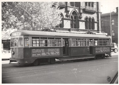
Photograph - PCC 980 Bourke St at Spencer St, George Bishop, 1969
Photograph shows PCC tram 980 at the Bourke Street terminus near Spencer St. Tram has adverts for Dave Price second hand cars - High Street Northcote. In the background is the Melbourne Tramway and Omnibus Co. office building. Photo by George Bishop 1969.Yields information about the operation of tram 980 in Bourke St during 1969.Black and White Photograph of PCC 980 Bourke St at Spencer St.Details of the photograph and photographer on the rear in pencil and ink.trams, tramways, pcc class, tram 980, mtoco, mmtb, bourke st -
 Vision Australia
Certificate - Text, Certificate of Disability Support Certification registration, April 2003, 1 April 2003
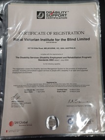
Certificate reads "Certificate of Registration. Royal Victorian Institute for the Blind, 557 St Kilda Road, Melbourne VIC 3004 Australia complies with the requirements of The Disability Standards (Disability Employment and Rehabilitation Program) Standards 2002, dated July 1 2002 for the following capability: This registration covers the Disability Services Management System for the provision of employment services, including personalised support services to people with a disability in an open and supported employment environment." Signed: Alex Ezrakhovich, General Manager Certification. Certificate #: DSC20047. Issue Date: 1st April 2003. Certified Date: 19th March 2003. Expiry Date 19th March 2006. The second certificate reads the same except for 201 High Street, Prahran.2 certificates with black writingAt the top of the page is a black and white image of a shell next to 'Disability Support Certification' which also has a red tick across the first 2 words.royal victorian institute for the blind, registration -
 Eltham District Historical Society Inc
Document - Folder, Shallard family
Jack and Mary Emma Shallard and their three children, Bill, Joyce and Jack, moved to the Eltham area around 1912. Jack married Blanche Everard and lived in Montmorency and was active in community matters. Contents Photocopy page, October 1920, re Eltham, noting Joseph Bromley Shallard as a Councillor for Eltham. Photograph: Eltham Historical Society display at home of Joy and Bruce Ness 1987, Les Robertson, Jack Shallard, Blanche Shallard and Margorie North. Photograph: Eltham Historical Society float, Eltham Festival Parade 1988, Blanche Shallard, Opal Smith and Eileen Gibbon. Manuscript and typed notes, no date: Memories of Eltham and district by Jack Shallard Newspaper article: "Jack Shallard will be sadly missed", Diamond Valley News, 18 June 1991. Obituary of Jack Shallard. Letter Elizabeth Pidgeon to Eltham District Historical Society, 20 March 2001: Seeking information on Shallard family of Eltham, provides information on Roberts and Tinker families. Newspaper death notice for Blanche Shallard, The Age, 12 September 2002. Newspaper funeral notice for Blanche Shallard, The Age, 13 September 2002. Order of Service: Blanche Emily Shallard, St Faith's Anglican Church, Montmorency, 13 September 2002. Eulogies for Blanche Shallard by Jan Mullins, Kerry Knowles, and grandchildren of Blanche Shallard. Letter Sue Law to the Shallard family, 15 September 2002. Acknowledging contribution of Blanche Shallard to EDHS and seeking copies of eulogies. Newspaper article: "Community honours a favourite resident", Diamond Valley Leader, 20 November 2002. Obituary of Blanche Emily Shallard with photograph. Notes, undated, of Sue Law's recollections from Blanche Shallard. Newspaper advertisement: "63 and 65 Rattray Road, Montmorency", Diamond Valley News, no date. For sale 63 and 65 Rattray Road, Montmorency. Newspaper advertisement: "63 and 65 Rattray Road, Montmorency", Diamond Valley Leader, 12 March 2003. Auction 5 April of 63 and 65 Rattray Road, Montmorency.Newspaper clippings, A4 photocopies, etcjoseph shallard, mary emma shallard nee tinker, elizabeth ann tinker nee roberts, susan shallard nee roberts, james roberts, sarah roberts nee pope, joseph bromley shallard, william shallard, joseph tinker, jack vincent shallard, jocelyn shallard, christopher shallard, elsie shallard nee mills, meruka house sherbourne road, mary north, jack shallard, blanche shallard nee everard, bill everard, eltham primary school, melbourne high school, university of melbourne, holy trinity church of england kew, st margaret's church of england eltham, st faith's church of england montmorency, best hooper rintoul and shallard, diamond valley community hospital, blanche emily shallard nee everard, 63-65 rattray road montmorency, jan mullins, kerry knowles, joy neww, bruche ness, les robertson, marjorie north, eltham festical parade 1988, opal smith, eileen gibbon, joyce shallard, falkiner street eltham, bridge street eltham, karingal drive montmorency, sherbourne road montmorency, "kaweka" sherbourne road montmorency, greensborough road eltham, eltham state school, rechabites hill henry street eltham, eltham hotel, boy scouts troup eltham, eltham district cricket association, first world war memorial tltham, eltham railway station -
 Bendigo Historical Society Inc.
Document - Hustlers, Sheepshead and Deborah lines of reef
Albert Richardson was a mining historian who wrote widely on the mines of the Bendigo Goldfield. The park opposite the Goldmines Hotel in Marong Road, is named in his honour. Five page document, hand written by Albert Richardson on lined foolscap and edited with cross-outs and insertions, . The mines along the Hustlers line of reef and the Sheepshead line of reef are described. Mines listed on Hustlers line of reef: Fortuna Hustlers (1888 - 1913), shaft 2,240 feet at rear of Buckell and Jeffrey's offices; Royal Hustlers Reserve No. 2 - two shafts 'City" 860 feet, now covered by R.S.L. building Pall Mall, steel poppet legs 60 ft high and 'Park Shaft" at rear of Camp Hill School, 1,775 feet, steel poppet legs 60 feet high; Hustlers Hill Group first worked by Jonathan Harris in 1853 and bounded by Valentine, Anderson and Ironbark Creek to the north and Milroy Street to the east, one of first areas worked for quartz reefing. It with Garden Gully line west and Victoria Hill Ironbark, formed by far the richest cross section of the Bendigo Goldfield. Great Extended Hustlers (1865-1921) close to intersection of Anderson Street and Hustlers Road, mullock heap against road and shored up around shaft, steel poppet legs now at Wattle Gully mine, Chewton, large winding machine, air compressor south of shaft and 36 head crushing battery. Hustlers Reef (Old Hustlers) and Hustlers Reef No. 1, two shafts, main 2,210 feet, about 220 yards east of Moran Street and against Fenton Street. , No. 1 shaft 1,140 feet and about 155 yards east of Moran Street. Lansell's Comet, Lightining Hill line, 2.100 feet, on Comet Hill approx 70 yards west of Holmes Road, near Comet Creek, steel poppet legs. United Hustlers and Redan (1876-1918), main Redan, 1,830 feet about 155 yards west of Sandhurst Roead, in line with Comet Hill State School, this hill known as Redan Hill. North, or New Hustlers, once known as Agnew Hustlers, wooden poppet legs, south side, Kneebone Street, Eaglehawk. Derby line, Johnson's No. 3, South Johnson's (east shaft of Collman and Tacchi) 439 feet on west wide of Woods Street, south of Wetherall Street. Paddy's Gully Line, south to north, some shafts - Lansell's 'Sandhurst" ('Needle") Eaglehawk Road shaft 2,425 feet, about 50 yards east of Needle Loops, a brick square sided chimney with Cleopatra Needle top. British American, 789 feet, just south of Holdsworth Road. Collman and Tacchi, main shaft 2,588 feet, 60 yards west of Eaglehawk Road, California Gully. Deborah Line of Reef, The Deborah (1932-1954) shaft 2.017 feet, west of Adams Road and south of Abel Street, Quarry Hill. North Deborah (1937 - 1954) shaft 1,151 feet, Breen Street, Quarry Hill, steel poppet legs. Central Deborah (1939-1954) shaft 1,347 feet Sheepshead line of reef, Lansell's South Red, White and Blue, shaft 2,124 feet, north east of Bellevue Road and 220 yards east of Adams Road. The New Red, White and Blue Consolidated (Big Blue) main shaft 2,416 feet. Lansell's Bendigo Battery 105 head, north of 'Big Blue" on his freehold lease, commenced crushing on 24th February 1895. After closing was erected as the Showground's Industrial Hall, July 1926. North Red, White and Blue, burnt down February 1926, new company 1934, closed 1938. Document is part of the Albert Richardson Collection of Bendigo mining history. bendigo, gold mining, deborah line of reef, sheepshead line of reef, hustlers line of reef, royal hustlers reserve mine, hustlers hill group of mines, great extended hustlers, hustlers reef no. 1, lightning hill line, old comet, collman and tacchi, lansell's comet, north deborah, central deborah, dhrrpdhrsf linr og trrg, new red, white and blue consolidated mine, big blue, lansell's bendigo battery, north red, white and blue mine, albert richardson collection -
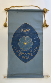 Kew Historical Society Inc
Banner - Kew Elder Citizens Association banner
The Kew Elderly Citizen's Association was formally established in 1952. During its initial years it met at South Esk in Cotham Road. Later the Club moved to its headquarters in High Street. During the period of its existence, the club changed its name a number of times It finally became known as the Kew Senior Citizens.Handmade and painted canvas banner in shades of blue with a golden cord with tassels. The banner represents the symbol of the Kew Elder Citizens Association: a forget-me-not in the centre with laurel leaves below. "KEW / E.C.A."kew elderly citizens association, kew elder citizens, kew senior citizens, community groups -- kew (vic.), banners