Showing 17001 items
matching plenty-river
-
 Lakes Entrance Regional Historical Society (operating as Lakes Entrance History Centre & Museum)
Photograph, 1910
Black and white photograph of the TSS Wyrallah with crew and passengers standing on after deck while steaming slowly down the Mitchell River near Bairnsdale VictoriaTSS Wyrallah Passing down Mitchell River 1910bridges, waterways -
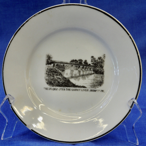 Orbost & District Historical Society
plate
This item is an early souvenir of the local district.Small white plate with black rim. Black and white illustration of the bridge over the Snowy River at Orbost.Back - Made in Orbost. Front - The Bridge Over The Snowy River At Orbost, Vic.plate souvenir snowy-river orbost -
 Federation University Historical Collection
Map - Geological, Tallangatta, New South Wales: 1:250,000 Geological Series, SJ 55-3, 1966, 1966
Compiled by the Geological Survey of N.S.W., Division of Regional Geology. Topographical base compiled from Snowy Mountains Hydro Electrical Authority, Department of Lands, County maps and Snowy Lease Map. Other sheet adjoin this map. There are 13 formation sections grouped into 9 - Quaternary, Tertiary, Middle Devonian, Lower to Middle Devonian, Lower Devonian, Upper Silurian, Silurian, Upper Ordovician and Ordovician.Large coloured map showing geological features, faults, bores, rivers and mineral deposits.Scale of map, longitude and latitude, river names. "Tallangatta 1:250,00" written in black pen.tallangatta, new south wales, geological survey, topographical base, snowy mountains hydro electrical authority, department of lands, snowy lease map, department of mines, quaternary, tertiary, middle devonian, lower to middle devonian, lower devonian, uper siluran, silurian, upper ordovician, ordovician -
 Port of Echuca
Colour Photograph, Approx.1979
This photo shows a river boat under construction on the eastern bank of the Murray river in the Echuca Port area where the boat shed and swimming pool were located in the 1970's. The boat shed can be seen through the trees but the swimming pool isn't visible. There is another river boat behind, possibly the Canberra.This photograph is of historical and social significance in that it shows the condition of the Murray river in the 1970's at an area used as the local swimming area on the Echuca side of the river. There is a river boat under construction (the frame work shows a bottom and top storey on the boat). This could be the Pride of the Murray. It is difficult to see the name on the river boat behind but it looks like the Canberra. Three houseboats are moored together, a bit further down the river.Colour photograph (post card size) of the Murray river looking north towards the boat shed building. Two river boats are moored by the left bank close to the swimming pool and three house boats can be seen moored further down the river. The river boat in the fore ground is under construction.Printed on reverse:" this paper manufactured by Kodak". Written in blue pen"12B"echuca, port of (riverboats), echuca, port of -
 Eltham District Historical Society Inc
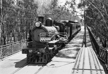
Photograph, VR Commissioner's Special train, steam locomotive D3-639 crossing the Echuca-Moama Road Rail Bridge over the Murray River from Moama, NSW to Echuca, Victoria, 1962
VR Commissioner's Special train, steam locomotive D3-639 crossing the Echuca-Moama Road Rail Bridge over the Murray River from Moama, NSW to Echuca, Victoria. Commissioner Edgar Henry Brownbill on footplate, 1962. Commissioner Edgar Henry Brownbill was in office 1957 to 1967. George Coop advises - "The train on the Eltham/Moama bridge is actually the Commissioner’s Special on one of its inspection tours of the VR rail system. This was a very grand special train with accommodation for the Commissioner and staff in carriages also used once for the Royal Train and other State purposes. You can just see the Commissioner of the day, dressed in his suit and wearing engine drivers gloves, standing in the loco cab doorway. A good ‘hands on’ impression is created amongst local staff if can be seen that the boss is no ‘desk jockjey’. The observation car on the back was originally made for the ’Spirit of Progress’. I climbed up onto the bridge iron plate work to get this view. It was safe enough as the cantilevered pedestrian walkway was still on the east side at the time." "I was resident in Echuca from Jan. ’59 to approx. May ’64. At that time the single Echuca/Moama bridge was a combined road/rail bridge. The rail gauge was 5’3” and still is, I believe, on the new bridge that sits just upstream of the old one. This rail line into NSW has always been 5’3" gauge because it has no connection with any NSW tracks. The old Echuca/Moama bridge, locally called the ‘Iron Bridge’ has, over years, undergone some structural changes. The two lattice iron hoops arcing over the roadway have been raised and lowered and changed design. Presently a pedestrian walkway is cantilevered off the west (or downstream) side of the bridge. It used to be on the eastern side. Guess changes went in when new rail bridge only was built on the eastern side as well." Image dated as c.1963 based on same image in Port of Echuca collection (possibly frame 32 of film) (print 19.5 x 24.5cm) On reverse in pencil: "Brown card" in black pen: "Commissioners special. F. Brown on Footplate. George C.L. Coop c1963". https://victoriancollections.net.au/items/59d575b921ea6e1278d78042 However based on frame no. 10, date set as 1962Digital TIFF file Scan of 35mm Ilford FP3 black and white negative transparencyd3-639, d3-class steam locomotive, echuca-moama road rail bridge, edgar henry brownbill, george coop collection, murray river, vr commissioner's special train -
Greensborough Historical Society
Oral History Transcript, Myrtle Barnett [interview] 19/02/1996, 19/02/1996
Oral history. Myrtle Barnett ( 1915- ) fostered daughter of Caroline & Ferdinand Barnett; Lower Plenty. 19 Feb 1996.Links: 00024:00741 Transcript of Oral History. Myrtle Barnett (1915- ), fostered daughter of Caroline and Ferdinand Barnett of Lower Plenty. Interviewed by Peter Blackbourn on 19th Feb 1996. Copy 2: Item 741.lower plenty, montmorency, myrtle barnett -
 Kiewa Valley Historical Society
Photo Framed - Broken Bridge, c1940's
The Tawonga Bridge over the East Kiewa River linked Mt Beauty with Tawonga. It was broken during Vera Hore's lifetime, 1909 - 2000. The bridge over the East Kiewa River enabled people to travel between Mt Beauty and Tawonga. Vera Hore (nee Ryder), the publican of the Tawonga Hotel, took this photo as she was a keen amateur photographer. Vera lived from Nov. 1909 to July 2000.Colored photo of 'Broken Bridge' over the East Kiewa River on Damm's Road with Mt Bogong, with snow, in the background of centre top. Framed with 2 cm wide cream cardboard surrounded by a metal decorated frame. The back has a flap for displaying the photo on a bench or table. On the back, a white sticker inscribed:- "Broken Bridge" / Old Timber Bridge / over East Kiewa River / on Damm's Rd." On the back top left corner hand written:- "Vera Hore"tawonga bridge; vera hore; east kiewa river; tawonga hotel -
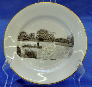 Orbost & District Historical Society
souvenir plate, Between 1925 and 1941
Illustration on plate is a family fishing party aboard the "Ripple" built by George Matthew Winchester. Shows Ethel (mother) with Lindsay Smooker on her knee. Harry, Elsie, Anita and H. Hermann about 1941. The Winchesters lived in Marlo and built boats near the Marlo hotel. The "Ripple" built by George Winchester at the age of 18 years was the first boat built by him. It was built in 1908. It has been noted in a profile of George Winchester done by his Daughter Olive Hunt (née Winchester) that was completed one year before her death in 2002.The Winchester family is a prominent local family.The Winchesters lived in Marlo and built boats near the Marlo hotel. This item is an example of a souvenir item made especially for Orbost.Very small white souvenir plate. Gold-rimmed with black illustration of people in a boat on the Snowy River.Front-Snowy River Orbost Back-Melba Bone China Guaranteed Made in Englandplate souvenir snowy-river orbost melba-china -
 Kew Historical Society Inc
Photograph - Yarra River, Kew, 1924
Henry Beater Christian (1886-1962) , was a descendant of one of the earliest settler families in Kew. Employed at the Kew Asylum as a 'public servant', he was a skilled amateur photographer, photographing numerous scenes in Kew and on his travels around Victoria. The majority of his photographs date from 1916 to 1929. His finest photographs are housed in two photograph albums. A dated early photograph of the Yarra River at Kew.Digital copy of a photograph from page 1 of the 47-page photograph album containing 261 gelatinous silver images, loaned by Diane Washfold with permission given to digitise and hold a copy in our collection. The image is a view of the Yarra with remnant large Eucalypts on either side of the river."Yarra River Kew 1924"henry beater christian (1886-1962), landscape photography, kew (vic.) — yarra river, christian-washfold collection, photograph albums -
 Port of Echuca
A black and white photographic postcard, Between 08/1906 - 10/1906
Photographic Postcards were very popular in the early 20th century and this shows the Campaspe river, Echuca in flood. The high water mark is exemplified by having the rower on the water. The water has inundated the surrounding bush with trees partly submerged along the right hand side of the photograph.Rowing clubs were popular in towns along the Murray river and this picturesque scene of the Campaspe river , Echuca in flood shows a man rowing a racing scull down the river.Black and white photographic postcard showing the Campaspe river, Echuca, in flood, with a man rowing a racing scull.On face : "Campaspe River, Echuca". On reverse: printed in ink :" Post Card. This space may be used for correspondence. For address only. Place penny stamp here." In pencil is written: "Aug Sep Oct 1906 Flood" "Donation H V Evans 85 Fullers Rd Chatswood NSW." " Echuca Regional Library" is stamped but has been crossed out in pen.campaspe river, echuca, echuca flood, 1906, rowing, echuca -
 Port of Echuca
Photograph, Original photo C.1910. Copy 1984
This photograph comes from the Dowell collection. Related to P000202. At the turn of the 20th century, the railway line carried produce from southern New South Wales and the Riverina to Melbourne. Goods trains were a very important mode to transport to our region and industrialisation of Echuca. Photograph of the Murray bridge at Echuca at low river with a goods train crossing the bridge. Image is seen from bank facing north from Echuca.Recto :"MURRAY BRIDGE Echuca"; Verso: "C.1910" "Low river"dowell collection, murray river bridge , echuca, murray bridge, echuca, steam engine goods train, railway, transportation, industrialisation -
 Kew Historical Society Inc
Photograph - Yarra River, Kew, 1924
Henry Beater Christian (1886-1962) , was a descendant of one of the earliest settler families in Kew. Employed at the Kew Asylum as a 'public servant', he was a skilled amateur photographer, photographing numerous scenes in Kew and on his travels around Victoria. The majority of his photographs date from 1916 to 1929. His finest photographs are housed in two photograph albums. A dated early photograph of the Yarra River at Kew.Digital copy of a photograph from page 1 of the 47-page photograph album containing 261 gelatinous silver images, loaned by Diane Washfold with permission given to digitise and hold a copy in our collection. The image is a view of the Yarra with a horse on the other side of the river standing near the solitary large tree."Yarra River Kew 1924"henry beater christian (1886-1962), landscape photography, kew (vic.) — yarra river, christian-washfold collection, photograph albums -
 Orbost & District Historical Society
black and white photograph, first half 20th century
The seed bean industry was a major industry in the Orbost district for the first half of the 20th century. The total area sown with beans for seed at Orbost was estimated to be about 1000 acres. Fisher Bros, grew or supervised the growing of approximately one quarter of the bean seed produced at Orbost, and, in addition, prepared for market and sold a considerable quantity for other growers. From Newsletter February 2015 : "the Fishers took over the old Butter Factory in Lochiel Street. They had sorting tables there in the 1920s. In Orbost, the Fishers had a Shell fuel depot at the back of the bean factory. The Fishers were very enterprising people, very smart. One of their uncles is supposed to have invented the knot that was used to tie the sheaves of hay in the fields. At their Lochend Barn, they had a Blackstone engine which ran on oil. They used to light a fire under it and hot it up to start it. This engine drove all the bean machinery in the barn" The seed bean industry was a major industry in the Orbost district for the first half of the 20th century. the Fisher Brothers were a significant part of that industry.A black / white photograph tajen from a river bank. On the right behind some trees is a barn. On the left between tres is a small building. Reflections can be seen in the water.on back - "Snowy River, Fisher barn on right. Mary Gilbert"bean-industry fisher-beans snowy-river -
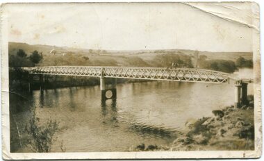
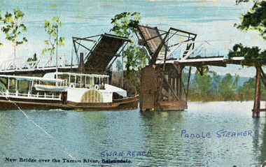 Lakes Entrance Regional Historical Society (operating as Lakes Entrance History Centre & Museum)
Photograph, V S M Series, 1920 c
Hand tinted postcard showing Paddle Steamer 'Tanjil' passing upstream under the open Swan Reach Bridge on the Tambo River, East Gippsland, Victoria.New Bridge over the Tambo River Swan Reach Paddle Steamerships and shipping, waterways, jetties -
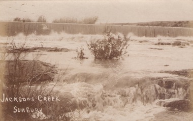 Sunbury Family History and Heritage Society Inc.
Photograph
The river in flood is the Jacksons Creek. This section of the river with the waterfall is downstream from the town of Sunbury.A sepia photograph in post card format of a river with waterfalls in flood.rivers, jacksons creek, sunbury -
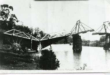 Lakes Entrance Regional Historical Society (operating as Lakes Entrance History Centre & Museum)
Photograph, Bulmer H D, 1925
Swan Reach Bridge collapsed 10.00 am 16 November 1925Black and white photograph showing collapsed bridge over the Tambo River, bridge collapsed at eastern end. Photo looking downstream. Two people on landing on far right bank behind right hand bridge pylon. Thick vegetation on bank. Swan Reach VictoriaSwan Reach Bridge on the Tambo Riverwaterways, boats and boating -
 Orbost & District Historical Society
black and white photograph, first half 20th century
This is the Dalgety bridge across the Snowy River. It is a steel construction.The first bridge over the river was constructed in 1888. There was a punt across the river before the bridge was built . Dalgety is a small service centre, located on the Snowy River approximately 235 km from Orbost. It was an early consideration for the site of Australia,s capital city. The Dalgety Bridge over the Snowy River has been an important item of infrastructure in the history of New South Wales for over 110 years. It was designed by noted bridge engineer J. A. McDonald,and was a technically sophisticated bridge structure for its time. This is a pictorial record of a significant structure on the Snowy River.A small black / white photograph of a large bridge over a river.bridge-dalgety-snowy-river -
 Eltham District Historical Society Inc
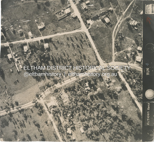
Photograph - Aerial Photograph, Main Road, intersection Grand Boulevard and Panorama Avenue, Lower Plenty / Montmorency, 2 Jul. 1951
Not originally catalogued in Shire of Eltham Archives but from the same series of photos taken for Country Road Board study of Main Road wideningshire of eltham archives, aerial photo, country roads board, eltham, main road, road widening, 1951-07, airlie road, ambulance station, beleura grove, grand boulevard, looker road, lower plenty, montmorency, panorama avenue -
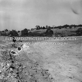
 Eltham District Historical Society Inc
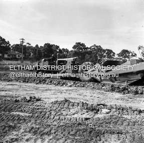
Negative - Photograph, J.A. McDonald, Reconstruction works, Lower Plenty Oval, Jan. 1961
3 February 1961 Looking towards Rattray RoadRecord of various Shire of Eltham infrastructure works undertaken during the period of 1952-1962 involving bridge and road reconstruction projects, sometimes with Eltham Shire Council Project Reference numbers quoted. It was during this period that a number of significant improvements were made to roads and new bridges constructed within the shire that remain in place as of present day (2022). In many situations, the photos provide a tangible visible record of infrastructure that existed throughout the early days of the Shire. The album was put together by or under the direction of the Shire Engineer, J.A. McDonald.1961-01, infrastructure, lower plenty oval, reconstruction works, shire of eltham -
 Eltham District Historical Society Inc
Negative - Photograph, J.A. McDonald, Reconstruction works, Lower Plenty Oval, Jan. 1961
3 February 1961 Looking towards Rattray RoadRecord of various Shire of Eltham infrastructure works undertaken during the period of 1952-1962 involving bridge and road reconstruction projects, sometimes with Eltham Shire Council Project Reference numbers quoted. It was during this period that a number of significant improvements were made to roads and new bridges constructed within the shire that remain in place as of present day (2022). In many situations, the photos provide a tangible visible record of infrastructure that existed throughout the early days of the Shire. The album was put together by or under the direction of the Shire Engineer, J.A. McDonald.1961-01, infrastructure, lower plenty oval, reconstruction works, shire of eltham -
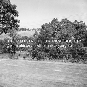 Eltham District Historical Society Inc
Negative - Photograph, J.A. McDonald, Eltham-Yarra Glen Road, Lower Plenty, c. July 1962
View looking west across Old Eltham Road to the Eltham-Yarra Glen RoadRecord of various Shire of Eltham infrastructure works undertaken during the period of 1952-1962 involving bridge and road reconstruction projects, sometimes with Eltham Shire Council Project Reference numbers quoted. It was during this period that a number of significant improvements were made to roads and new bridges constructed within the shire that remain in place as of present day (2022). In many situations, the photos provide a tangible visible record of infrastructure that existed throughout the early days of the Shire. The album was put together by or under the direction of the Shire Engineer, J.A. McDonald.1962-07, eltham-yarra glen road, infrastructure, lower plenty, lower plenty road, road construction, shire of eltham, old eltham road -
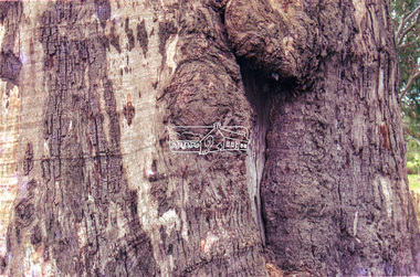
 Eltham District Historical Society Inc
Slide - Photograph, Unidentified significant tree, Eltham district, possibly Lower Plenty, c.1992
35mm colour positive transparency (1 of 6) Mount - Gepe (Sweden) Silver Greyunidentified, significant tree -
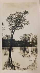
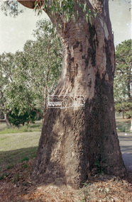
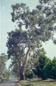
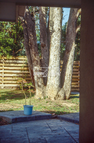
 Eltham District Historical Society Inc
Slide - Photograph, Unidentified significant tree, Eltham district, possibly Lower Plenty, c.1992
35mm colour positive transparency (1 of 6) Mount - Gepe (Sweden) Silver Greyunidentified, significant tree -
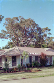
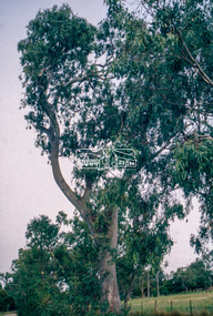
 Eltham District Historical Society Inc
Slide - Photograph, Unidentified significant tree, Eltham district, possibly Lower Plenty, c.1992
35mm colour positive transparency (1 of 6) Mount - Gepe (Sweden) Silver Greyunidentified, significant tree -
 Eltham District Historical Society Inc
Slide - Photograph, Unidentified significant tree, Eltham district, possibly Lower Plenty, c.1992
35mm colour positive transparency (1 of 6) Mount - Gepe (Sweden) Silver Greyunidentified, significant tree -
 Eltham District Historical Society Inc
Slide - Photograph, Unidentified significant tree, Eltham district, possibly Lower Plenty, c.1992
35mm colour positive transparency (1 of 6) Mount - Gepe (Sweden) Silver Greyunidentified, significant tree -
 Eltham District Historical Society Inc
Slide - Photograph, Unidentified significant tree, Eltham district, possibly Lower Plenty, c.1992
35mm colour positive transparency (1 of 6) Mount - Gepe (Sweden) Silver Greyunidentified, significant tree -
 Eltham District Historical Society Inc
Slide - Photograph, Unidentified significant tree, Eltham district, possibly Lower Plenty, c.1992
35mm colour positive transparency Mount - Gepe (Sweden) Silver Greyunidentified, significant tree -
 Eltham District Historical Society Inc
Slide - Photograph, Unidentified significant tree, Eltham district, possibly Lower Plenty, c.1992
35mm colour positive transparency Mount - Gepe (Sweden) Silver Greyunidentified, significant tree -
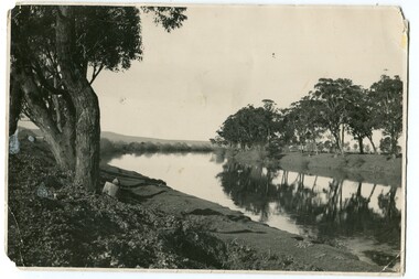
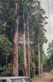
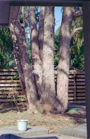
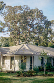
 Eltham District Historical Society Inc
Slide - Photograph, Significant tree, Lower Plenty, c.Apr. 1993
35mm colour positive transparency (1 of 22) Mount - Kodak EktachromeProcess Date "Apr M"significant tree, lower plenty