Showing 28535 items
matching street street
-
 Kew Historical Society Inc
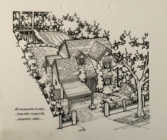
Drawing - Property Illustration, Margaret Picken, 33 Molesworth Street, Kew (aerial), 1993
... 33 Molesworth Street, Kew (aerial)...33 molesworth street... Molesworth Street, Kew by Margaret Picken.... molesworth street 33 molesworth street - kew (vic) 33 MOLESWORTH ST ...After training as a Cartographic Draftsman within the mining industry, I worked as a property illustrator for real estate firms in the eastern suburbs of Melbourne for 23 years from 1983. I initially photographed houses with a Polaroid camera and made a 'thumbnail' sketch while there. The photos were used to scale off a sketch in pencil and then that sketch was overlaid with drafting film and the 'pen and ink' completed. The pens I used were the Rotring ‘Rapidigraph’ drafting pens. The ink was also made by Rotring (German).The film was ‘Rapidraw’, polyester drafting film, double matte. It takes a very fine line and doesn’t bleed. As well as house sketches, there were often floor plans and site plans ordered. Aerial sketches were ordered when the property needed an overall view. (Margaret Picken, 2020)This drawing is one of a series created by Margaret Picken for a number of real estate agents in Melbourne between 1983 and 2005. Each work is signed and dated by the artist.Gift of Margaret Picken, 2020Pen and ink architectural drawing on drafting film of 33 Molesworth Street, Kew by Margaret Picken.33 MOLESWORTH ST., KEW / MARGARET PICKEN ~93 / WOODARDS ~ KEWartist -- margaret picken 1950-, 33 molesworth street, 33 molesworth street - kew (vic) -
 Surrey Hills Historical Society Collection
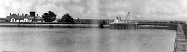
Photograph, Surrey Hills Reservoir No 1
... 10 pembroke street... Hills Reservoir No 1 on the corner of Tower Street built... of Tower Street built in c1892 at a cost of £12,000 to supply ...Copied by Ken Hall from an early postcard. This is Surrey Hills Reservoir No 1 on the corner of Tower Street built in c1892 at a cost of £12,000 to supply higher sections of the area. The builders were Jack and Bob Laudehr, partners in a wood yard in St. Kilda (Vic). They began by delivering firewood but extended to contract work involving timber. Another of their projects was to lay cable tram tracks commencing in Acland Street St. Kilda and running along The Esplanade. The reservoir in Canterbury Road was a large concrete structure built before the introduction of reinforcements. The excavated material was banked against the sides and pine trees were planted in it to add strength to the embankment. They were paid £2,000 for their work. Construction of Surrey Hills Number 2 Reservoir was completed in 1913 and the accompanying tower was built in 1929. It is assumed that the Miss Hill as the source of the donation (via Bill Dempsey) was Ivy Annie Hill (1902-1984). She was the only female child of William Valentine Dempsey to not marry. Bill Dempsey's mother was Laura Constance 'Birdie' Hill (1900-1968) who married Albert Dempsey.A sepia photograph within a post card of a reservoir on Canterbury Road, Surrey Hills. In the background to the left you can see the top halves of two houses and the tops of some trees. The photo takes up only the central section of the postcard.Below the photo on the front of the postcard on blue biro "Reservor [sic] Canterbury Rd / Surrey Hills." On the rear in grey lead pencil in Jocelyn Hall's handwriting: "Donor W Dempsey ------------- Keep / (nephew) / [arrow pointing down] / From Miss Hill / 10 Pembroke St SH / This house can be / seen in front of / No 12 which has / tower"1890, water supply, mmbw, edward d dyer (mr), 10 pembroke street, 12 pembroke street, surrey hills, ivy annie hill (miss), william valentine hill (mr), canterbury road, tower street, water supply structures and establishments, dams and reservoirs, jack laudehr (mr), bob laudehr (mr) -
 Port Fairy Historical Society Museum and Archives
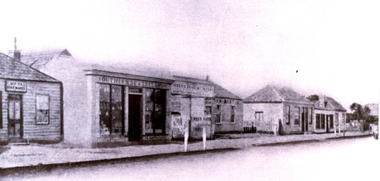
Photograph
... street...Sackville Street...Sackville Street, Port Fairy, South West, Victoria... Street Port Fairy great-ocean-road Sackville Street street town ...Sackville StreetBlack and white photograph after treatment by conservatorstreet, town, sackville street -
 Port Fairy Historical Society Museum and Archives
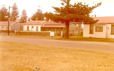
Photograph
... campbell street...Campbell Street 26 to 30...Coloured photograph of a row of houses in Campbell Street... Street Port Fairy great-ocean-road Campbell Street 26 to 30 ...Campbell Street 26 to 30Coloured photograph of a row of houses in Campbell Streetcampbell street, houses, cottages, street -
 Canterbury History Group
Photograph - Canterbury from Balwyn Hill
... Logan Street... melbourne Canterbury Balwyn Road Balwyn Hill Logan Street Baptist ...Sepia photograph of Canterbury from Balwyn Hill (Balwyn Road) similar to photograph no 404, but enlarged and with different lettering.canterbury, balwyn road, balwyn hill, logan street, baptist church, street trees, horse drawn vehicles, hazeldene, kerbing and guttering, canterbury gardens -
 Eltham District Historical Society Inc
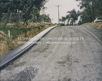
Photograph - Colour Print, Shire of Eltham, Bolton Street, Eltham, just north of Sackville Street intersection, c.1983
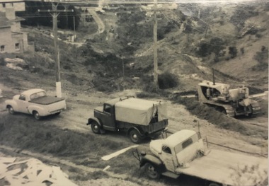
... Bolton Street, Eltham, just north of Sackville Street...Bolton Street... in Sackville Street about 200 m away which has been dated as c.1983... in Sackville Street about 200 m away which has been dated as c.1983 ...A single rollover kerb has just been laid on western side cut into the embankment. At the crest of the hill on right in front of the Ford Laser is a fire hyrdant. This photo was processed at the same time as image EDHS_07261 of roadworks in Sackville Street about 200 m away which has been dated as c.1983 (between Sep 1982 and May 1983). The paling fence on the left has a change of angle just before the crest of the hill then flattens. More recent Google Streetviews show the same fence and shape and in more recent times a new fence but same shape. Google Streetview for Jan 2008 indicates a more recent road widening and new profile kerb and channel. The embankment was further cut away and the footpath that was adjacent to the fence lowered to road level. The fire hydrant that was on the right hand side has been relocated to the left next to the footpath. Significantly more electrical wires are now strung on the telephone poles. In 2017 Bolton Street was again upgraded. The fire hyrdrant was then relocated to another (unknown) location.1983, footpaths and gutters, road construction, road drainage, road sealing, bolton street, eltham, sackville street -
 Ballarat Heritage Services
Photograph - church, Former Joseph Street Paton Memorial Presbyterian Church, Canadian, 2008, 26 /04/2008
... Former Joseph Street Paton Memorial Presbyterian Church...joseph street ballarat...Colour photograph of a weatherboard church in Joseph Street...Joseph Street, Ballarat, Victoria, Australia... was taken. joseph street ballarat joseph street canadian former ...The Jubilee of this church was held in 1933. "Paton Memorial Presbyterian Church. BALLARAT, Sunday Jubilee celebrations of the Paton Memorial Presbyterian Church were well attended in the week end. A basket picnic on Saturday at Eureka Stockade reserve was followed at night by a social gathering, at which a birthday cake was cut by Mrs. Amor, a foundation member. On Sunday special services were led by Rev. J. A. Moscript, assisted by the young men of St. John's Church. The church was originally founded, by the late Mrs. J. P. Murray to mission to the needs of the busy mining community which existed in Canadian in early years." (The Age, 06 November 1933.) PATON MEMORIAL CHURCH - An interesting tree-planting ceremony was performed in the grounds of the Paton Memorial Church on Saturday lost. Trees were put in by the scholars of the Sunday school to commemorate the enlistment of all the boys who had in any way been connected with the church. Sunday school, and Young Men's Club. The Mayor (Cr Levy) spoke in terms of praise of the lads who had enlisted to fight for right against might and the tyranny of Prussian militarism. The Hon. R. McGregor MLA., and the Revs. A. H. Moore and W. Rowlands were among those present. on also Mesdames J. P. Murray and McGowan, two of the founders of the church. During the afternoon Cr Levy planted a tree in honor of Mrs Murray. Afternoon tea was served by the ladies of the congregation. (The Age, 06 November 1933.) This church was in the middle of a Chinese neighbourhood, and the 1800s the leprosarium was in the vicinity. This bhurch was demolished not long after this photo was taken. Colour photograph of a weatherboard church in Joseph Street, Canadian. In 1937 this church was under the control of St. John's Peel-street, Ballarat. Members of the congregation: * Mrs. Amor - A foundation member. * Thomas Clarke and Isabella Clarke (formerly Ross) lived next door and according to family members "had a lot to do with the church". * Mrs McGowan - a founder of the church * Mrs. J. P. Murray founded the church to mission to the needs of the busy mining community which existed in Canadian in early years. joseph street ballarat, joseph street canadian, former joseph street paton memorial presbyterian church, ballarat, church, weatherboard church, presbyterian church, paton memorial church, clayton hill, claytons hill, leprosarium, chinese -
 Bendigo Historical Society Inc.
Photograph - DRESHER JEWELLER: BRIDGE ST
... 26.11.1999 ' Globe was in Mitchell Street near Wills... was in Mitchell Street near Wills Street' D. Walker 5.11 1999 'suggest ...Phillip Dresher (1823-1906), was born in Germany and emigrated to Ireland before coming to Australia in 1852. He was married to Margaret Cosgrove. After Phillip died his son John Thomas (1873-1919) took over the business. John Thomas was also a watchman for the fire brigade.black and white photograph. Part of commercial streetscape, Level shop front, upper residential. Dresher Watchmaker Jeweller, Globe Hotel, R. hand verandah, shop not identified. Two trees, paved footpath, bench seat, small child by Dresher window. Gas light outside bar, twin doors to bar,unknown - reprintorganization, business, dresher jeweller, globe hotel, re location: j. lerk, 26.11.1999 ' globe was in mitchell street near wills street' d. walker 5.11 1999 'suggest dresher, jeweller, bridge street, bendigo close to hibernia hotel. -
 Federation University Historical Collection
Plan, Ballarat School of Mines Schematic Proposal for the Former Ballarat Brewery Site
... Lydiard Street South... of Lydiard Street South ... of Lydiard Street South ballarat school of mines brewery building ...The Project Manager for the Ballarat School of Mines Brewery Building was Peter Davies. The plan suggests the closure of Lydiard Street South Copy of the Site plan for the Ballarat School of Mines Brewery Building, built on the site of the former Ballarat Brewery. The plan shows where the new building sites in relation to all other buildings at the Ballarat School of Mines ballarat school of mines, brewery building, ballarat brewery, architectural plans, schematic proposal, smb campus, former ballarat gaol, chimney tower, m.b. john building, lydiard street south, armstrong street south -
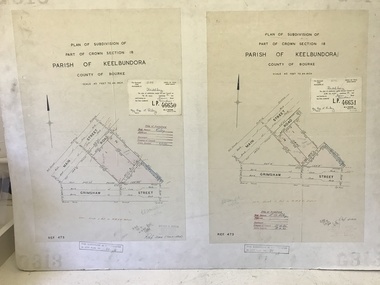 Greensborough Historical Society
Poster - Planning Document, City of Heidelberg, Subdivision Plan # G313, Corner Main and Grimshaw Streets, Greensborough, 08/03/1960
... main street greensborough...Plan of Subdivision at corner of Main and Grimshaw Streets...Plan of Subdivision at corner of Main and Grimshaw Streets ...Plan of Subdivision at corner of Main and Grimshaw Streets, Greensborough.An example of hard copy subdivision plans from the Greensborough area. Mainly from the Shire of Diamond Valley era (1964-1994).Plan (2 sheets) mounted on heavy card.Stamped and handwritten Council permissions, dates and other details.subdivision plans, main street greensborough, grimshaw street greensborough -
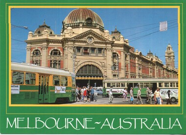 Melbourne Tram Museum
Postcard - Flinders Street Station - Z and SW5 class trams, Australian Souvenirs and Marketing Pty Ltd, mid 1980's
... Flinders Street Station - Z and SW5 class trams...Flinders Street station...Postcard - image of Flinders Street Railway Station... Postcard - image of Flinders Street Railway Station, corner ...Postcard - image of Flinders Street Railway Station, corner of Swanston Street with a green and yellow Z1 class tram and SW5 779 in the view. Based on photo of the Z class tram has been painted in The Met colours, photo mid 1980's. Tram 779 has a The Met sticker over the former MMTB logo. It was withdrawn during Oct. 1989 and sold during 1990. There are advertisements for Fish Paste and Canon typewriters. Produced by Australian Souvenirs and Marketing Pty Ltd of Moorabbin. Has an AMS logo.Demonstrates an iconic Melbourne image, Flinders Street Station with trams during the changeover from the MMTB to The Met.Postcard colour - Flinders St Station - Australian Souvenirs & Marketing Pty Ltd, card No. 40-03-1007trams, tramways, flinders street station, swanston street, z class tram, tram 779, sw5 class tram, the met -
Eltham District Historical Society Inc
Document - Folder, Shallard family
... Falkiner Street Eltham... Shallard Falkiner Street Eltham Bridge Street Eltham Karingal Drive ...Jack and Mary Emma Shallard and their three children, Bill, Joyce and Jack, moved to the Eltham area around 1912. Jack married Blanche Everard and lived in Montmorency and was active in community matters. Contents Photocopy page, October 1920, re Eltham, noting Joseph Bromley Shallard as a Councillor for Eltham. Photograph: Eltham Historical Society display at home of Joy and Bruce Ness 1987, Les Robertson, Jack Shallard, Blanche Shallard and Margorie North. Photograph: Eltham Historical Society float, Eltham Festival Parade 1988, Blanche Shallard, Opal Smith and Eileen Gibbon. Manuscript and typed notes, no date: Memories of Eltham and district by Jack Shallard Newspaper article: "Jack Shallard will be sadly missed", Diamond Valley News, 18 June 1991. Obituary of Jack Shallard. Letter Elizabeth Pidgeon to Eltham District Historical Society, 20 March 2001: Seeking information on Shallard family of Eltham, provides information on Roberts and Tinker families. Newspaper death notice for Blanche Shallard, The Age, 12 September 2002. Newspaper funeral notice for Blanche Shallard, The Age, 13 September 2002. Order of Service: Blanche Emily Shallard, St Faith's Anglican Church, Montmorency, 13 September 2002. Eulogies for Blanche Shallard by Jan Mullins, Kerry Knowles, and grandchildren of Blanche Shallard. Letter Sue Law to the Shallard family, 15 September 2002. Acknowledging contribution of Blanche Shallard to EDHS and seeking copies of eulogies. Newspaper article: "Community honours a favourite resident", Diamond Valley Leader, 20 November 2002. Obituary of Blanche Emily Shallard with photograph. Notes, undated, of Sue Law's recollections from Blanche Shallard. Newspaper advertisement: "63 and 65 Rattray Road, Montmorency", Diamond Valley News, no date. For sale 63 and 65 Rattray Road, Montmorency. Newspaper advertisement: "63 and 65 Rattray Road, Montmorency", Diamond Valley Leader, 12 March 2003. Auction 5 April of 63 and 65 Rattray Road, Montmorency.Newspaper clippings, A4 photocopies, etcjoseph shallard, mary emma shallard nee tinker, elizabeth ann tinker nee roberts, susan shallard nee roberts, james roberts, sarah roberts nee pope, joseph bromley shallard, william shallard, joseph tinker, jack vincent shallard, jocelyn shallard, christopher shallard, elsie shallard nee mills, meruka house sherbourne road, mary north, jack shallard, blanche shallard nee everard, bill everard, eltham primary school, melbourne high school, university of melbourne, holy trinity church of england kew, st margaret's church of england eltham, st faith's church of england montmorency, best hooper rintoul and shallard, diamond valley community hospital, blanche emily shallard nee everard, 63-65 rattray road montmorency, jan mullins, kerry knowles, joy neww, bruche ness, les robertson, marjorie north, eltham festical parade 1988, opal smith, eileen gibbon, joyce shallard, falkiner street eltham, bridge street eltham, karingal drive montmorency, sherbourne road montmorency, "kaweka" sherbourne road montmorency, greensborough road eltham, eltham state school, rechabites hill henry street eltham, eltham hotel, boy scouts troup eltham, eltham district cricket association, first world war memorial tltham, eltham railway station -
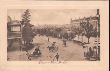 Bendigo Historical Society Inc.
Postcard - HARGREAVES STREET, BENDIGO
... HARGREAVES STREET, BENDIGO...hargreaves street...Sepia tint postcard: image shows Hargreaves Street...BENDIGO Streetscape hargreaves street Bendigo Hargreaves ...Sepia tint postcard: image shows Hargreaves Street, Bendigo. Looking NE, trees on either side of street. Unpaved, three horse and traps in foreground, tram on RH side. Appears to be taken from Mitchell Street corner. Written on rear in black pen: Bendigo 27.1.15, Dear Merle (Bush?) Many thanks for your letter. Things have changed since I last wrote to you. I do not know when I will be going to Melbourne, so sill still be here when you return, I expect. Glad to hear you are having a good time. With love, Arthur.bendigo, streetscape, hargreaves street, bendigo, hargreaves street, bush. -
Ballarat Heritage Services
Document, 116-122 LYDIARD ST N & 8-10 MAIR ST BALLARAT CENTRAL VIC 3350
... Lydiard STreet North...Lydiard STreet North Mair Street architecture Railway ...lydiard street north, mair street, architecture, railway station, c.d. cuthbert, robert dunn, reid's coffee palace -
 Linton and District Historical Society Inc
Photograph, Martin Photo 72 Webster St, Ballarat, Royal Standard Hotel and Post Office, Linton
... Sussex Street Linton... and Clyde Streets, Linton. The Post Office, Bank of NSW building...Sussex Street Linton Clyde Street Linton Royal Standard ...Sepia photograph of buildings on the junction of Sussex and Clyde Streets, Linton. The Post Office, Bank of NSW building and Bryant's shop can be seen on the RHS, the Royal Standard Hotel on the LHS. The photograph has been mounted on grey card.On back: "Esther Cluff Linton".sussex street linton, clyde street linton, royal standard hotel, post office, frank bryant's shop, bank of nsw linton -
 Linton and District Historical Society Inc
Photograph, Remains of Preston's Shop
... Sussex Street Linton... and Gillespie Streets in Linton...."Remains of Preston shop, cnr Sussex & Gillespie Streets. c...Preston Shop Sussex Street Linton Gillespie Street Business ...Black and white photograph showing, on the left, a small white weatherboard shopfront with an iron roof . There is no verandah but two windows and a central doorway. On the right of the photo is the old Blacksmith's Forge and residence (formerly Wishart's). Photo taken around 1982, on the corner of Sussex and Gillespie Streets in Linton."Remains of Preston shop, cnr Sussex & Gillespie Streets. c. 1982".preston shop, sussex street linton, gillespie street, business, 1982, main street, forge, blacksmiths, preston family, wishart family -
 Greensborough Historical Society
Article, R. A. Marsh, Church Street Greensborough, 1907_
... R. A. Marsh, Church Street Greensborough...church street greensborough... street greensborough hailes street greensborough Some handwritten ...Deals with a tenancy agreement between the Marsh and Partington families. In particular a dispute about a log crossing on the Plenty River, the access to which was across Marsh's land. There is also a brief family history of the Marsh family in Greensborough.Marsh and Partington families are Greensborough pioneer families.Collection of documents relating to the Marsh family. Some handwritten documents.marsh family, partington, greensborough, plenty river, church street greensborough, hailes street greensborough -
Glen Eira Historical Society
Document - Grange Road, 77, Glen Huntly
... Holloway Street... Road Glen Huntly Holloway Street Ormond Emma Street Grange Road ...This file contains 4 items about the purchase and construction of this property: 1/ The original contract of sale of land dated 25/09/1936 for Gertrude & Hulbert Gorrie situated on the corner of Grange and Neerim Road. 2/ The original typed building agreement dated 25/09/1936 between the contractor Ernest F Barnard and the purchasers Mr & Mrs Hulbert Gorrie. 3/ The original blueprint plan of a brick villa at the corner of Grange & Neerim Road for Mr & Mrs Hulbert Gorrie. Dated 25/09/1936. 4/ The original specification for the dwelling on the corner of Grange & Neerim Road, Glen Huntly for Mrs Gertrude Gorrie & Mr Hulbert Hopetoun Gorrie by builder Ernest F Barnard.barnard ernest f, gorrie gertrude, gorrie hulbert hopetoun, hobart john bertram, coorigil road, carnegie, holloway st, ormond, chemists, parish of prahran, caulfield county of bourke, building agreement, brick houses, builders, plans, architectural drawings, grange road, glen huntly, holloway street, ormond, emma street, grange road, neerim road, gorrie h.h, gorrie gertrude, gorrie hulbert h, legal documents, barnard ernest franklin, e. j. & h. amos, hintons nursery, real estate agents, murrumbeena, caulfield -
Tatura Irrigation & Wartime Camps Museum
Photograph, Tatura Bird's Eye
... Street, Hogan Street Railway Crossing, Horse-drawn cart, fences....Tatura Irrigation & Wartime Camps Museum 49 Hogan Street ...Bird's eye view of Tatura; features Criterion Hotel, Hogan Street, Hogan Street Railway Crossing, Horse-drawn cart, fences.tatura, buildings, historic, transport, railway, horse -
Port Melbourne Historical & Preservation Society
Photograph - Former corner shop, Ross Street sign, Jan 2002
... Former corner shop, Ross Street sign...Colour photograph of the Corner Shop No. 207 Ross Street... of the Corner Shop No. 207 Ross Street & Bridge Street Jan. 2002 ...Colour photograph of the Corner Shop No. 207 Ross Street & Bridge Street Jan. 2002. An original street name sign on the veranda of the shop.built environment - domestic -
 Charlton Golden Grains Museum Inc
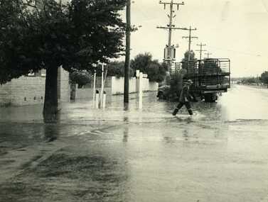
Photograph, Cameron, Ian, 1972 Flash Flood, Jan 1972
... Armstrong Street...B/W photograph of 1972 flash flood Corner High Street.... Flood Charlton Armstrong Street B/W photograph of 1972 flash ...1972 Flash flood, cnr of High St and Armstrong St, Charlton.B/W photograph of 1972 flash flood Corner High Street & Armstrong Streets. Man crossing road through flood water.flood, charlton, armstrong street -
Whitehorse Historical Society Inc.
Article, The place to go for a job|Ambulance in their pocket, 1979
... Station Street... Street and Bank Street, Box Hill. Proposed establishment... job centre on the corner of Station Street and Bank Street... of Station Street and Bank Street, Box Hill. Proposed establishment ...Photocopy of two unrelated articlesPhotocopy of two unrelated articles|Establishment of a new job centre on the corner of Station Street and Bank Street, Box Hill|Proposed establishment of an Ambulance Depot to service the 'Nunawading Pocket' comprising Box Hill, Nunawading and the southern part of Doncaster.Photocopy of two unrelated articlesaustralia. commonwealth employment service., station street, box hill, bank street, box hill, mcdonald, wayne, ambulance stations, city of nunawading, rotary club of nunawading -
 Bendigo Historical Society Inc.
Document - DOCUMENT DESCRIBING BUSINESSES IN BENDIGO CBD
... . The document describes various shops and businesses along View Street... Inc. History House 11 Mackenzie Street Bendigo goldfields ...Eight pages handwritten document, author and date unknown. The document describes various shops and businesses along View Street, Pall Mall, Mitchell street and Hargreaves Street.bendigo, business, various -
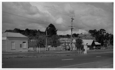
 Kew Historical Society Inc
Photograph, C Stuart Tompkins ARPS, Construction of Stawell and Yarra Streets, 1956
... yarra street (kew)...Yarra Street in the Studley Park section of Kew... Yarra Street, Kew from upper Stawell Street during street... Yarra Street in the Studley Park section of Kew was subdivided ...Yarra Street in the Studley Park section of Kew was subdivided in the 1940s and 1950sSmall black and white photograph looking north-west down Yarra Street, Kew from upper Stawell Street during street construction in 1956. Homes at 32 Stawell Street and 5 Yarra Street are partially visible on left.yarra street (kew) -
 Ringwood and District Historical Society
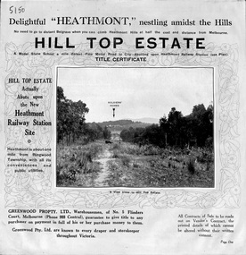
Pamphlet, Atlas Press Pty. Ltd., Melbourne, Land Sale Brochure, Hill Top Estate, Heathmont, Vic. - circa 1925
... , Edith Street, Edna Street, and Great Ryrie Street.... Heathmont Road, Balfour Avenue, Edith Street, Edna Street, and Great ...Twelve page land sale brochure promoting Heathmont and Ringwood area including photographs, subdivision features and local facilities. Subdivision plan includes Heathmont Road, Balfour Avenue, Edith Street, Edna Street, and Great Ryrie Street. -
 Ringwood and District Historical Society
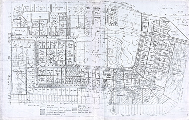
Document, Plan of Subdivision - Part of Crown Portion 5, Parish of Ringwood, County of Bourke - (Undated)
... Map includes Nelson Street and Ringwood Street, Ringwood...Map includes Nelson Street and Ringwood Street, Ringwood ...Map showing layout of 4 numbered allotments coloured red and land coloured blue appropriated or set aside for drainage and sewerage puposes.Map includes Nelson Street and Ringwood Street, Ringwood, Vic. -
 Robin Boyd Foundation
Document, Plan
... reserve between Gardeners RD, Universal Street, Grafton Street...Robin Boyd Foundation 290 Walsh Street South Yarra ...Plan of Eastlakes development NSW (north of Botany) with home units, housing commission, shopping centre and public reserve between Gardeners RD, Universal Street, Grafton Street, Florence Street and Maloney Street.Photocopy, double page taped on reverse. Handwritten and typewritten. -
 Bacchus Marsh & District Historical Society
Map, Main Road and Gell Street Allotments
... Main Road and Gell Street Allotments ...Gell Street Land Allotments...This map shows allotments of land along Gell Street Bacchus... Road (Main Street) and Gell Street areas of Bacchus Marsh...This map shows allotments of land along Gell Street Bacchus ...This map shows allotments of land along Gell Street Bacchus Marsh running between Main Road (now called Main Street) and Lerderderg Street. The total area of the map encompasses Main Road, Church Street, Lerderderg Street and Gell Street. 36 allotments of land are shown. Three allotments which connect to Main Road are shaded in pink. The date of the map has not been established but the National Bank building erected in 1865 near the Border Inn is indicated which indicates that the map dates from after 1865. Reports in the Bacchus Marsh Express newspaper on 5 March 1870, page 2, column 6 announced building lots in Gell Street had been withdrawn from sale by the agent J.E. Crook. Later reports in the Express on 1 November 1873, page 2, column 2 advertised 14 allotments of land in Gell Street for sale. Single page map showing allotments of land along the Main Road (Main Street) and Gell Street areas of Bacchus Marsh. Part of a set of maps which are pasted into a bound volume containing 76 maps or plans in total. High resolution digital image stored on BMDHS computer network. bacchus marsh victoria maps, gell street land allotments, main street land allotments -
 Grey Street Primary School, Traralgon
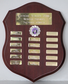
Shield, Latrobe Valley Zone Winter Sports Netball (Girls)
... , 2008 Grey Street, 2009 Grey Street, 2010 St Michael's, 2011...Grey Street Primary School, Traralgon 30-44 Grey Street ...2005 Traralgon South, 2006 St Gabriel's, 2007 Stockdale Rd, 2008 Grey Street, 2009 Grey Street, 2010 St Michael's, 2011 Newborough East, 2012 Newborough East, 2013 Grey Street, 2014 Grey Street, 2015 Grey Street -
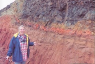 Kilmore Historical Society
Photograph, 91 Sydney Street
... 91 Sydney Street... Street, Melbourne Street at the top of the cutting. Now... on 91 Sydney Street (Missen fleet site) last July 2016...Kilmore Historical Society 4 Powlett Street Kilmore ...15cm x 10cm coloured photograph of the cutting at 91 Sydney Street, Melbourne Street at the top of the cutting. Now is the site of the car wash and KFC. Written on the back: Liz Dillon-Hensby against the cutting on 91 Sydney Street (Missen fleet site) last July 2016construction