Showing 173450 items matching "melbourne "
-
 Federation University Historical Collection
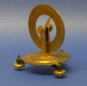
Scientific Instrument, H.B. Selby & Co. Pty Ltd, Magnetic Dip Needle
Brass scientific instrument used by students at the Ballarat School of Mines. Made specially for H B Selby & Co Pty Ltd (Melbourne)magnetic dip needle, scientific instruments -
 Melbourne Tram Museum
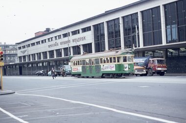
Slide, David Verrier, 28/04/1976 12:00:00 AM
Agfa colour slide, white blue plastic mount. Photograph by David Verrier. Tram W2 504 northbound in Spencer St outside the Spencer St Railway Station Photos taken 28/4/1976.In ink: "Wed 28/4/76 504 Spencer St Melbourne"trams, tramways, spencer st, w2 class, route 18, city, tram 504 -
 Melbourne Tram Museum
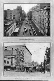
Photograph - Black & White Photograph/s, Tramway Museum Society of Victoria (TMSV), c1975
Black & White Photograph of a postcard made by the TMSV Sales consisting of two postcards showing cable trams in Elizabeth St, looking north from the Flinders St clock tower and Bourke St looking east from Swanston St. The first shows a bogie trailer being shunted. The second has the Myer store in the view. The first photo is dated between 1933 and 1935 based on the construction of the building next door to Hosies in 1933 and the closure of the cable lines in 1935. See 7-9 Elizabeth St - see https://s3.ap-southeast-2.amazonaws.com/hdp.au.prod.app.com-participate.files/8215/9494/3548/PROPERTY_103166_7TO9_ELIZABETH_ST.pdf - accessed 7-5-2022Has "TMSV 332 Flinders St Melbourne 3000" stamp on the rear.trams, tramways, cable trams, shunting, elizabeth st, bourke st, bogie cable trailers -
 Stawell Historical Society Inc
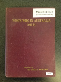
Book, The Herald, Who's Who In Australia 1933-34, 1933-1934
Short Bios of notable Australians Maroon Hard cover, with gold printWho's Who in Australia 1933-34 Published by the Herald Sun, Melbournestawell -
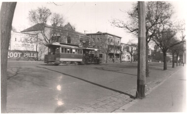 Melbourne Tram Museum
Photograph - Cable tram Nicholson St, Eric Victor Copeman, 21-9-1938
The photograph shows a cable tram set, in Nicholson St Fitzroy. Cannot determine the tram number. In the background is an advertisement for Indian Root Pills and a Mr Jones - a Labor candidate. Note the location of the street trees. Photographer Eric Victor Copeman - based on the handwriting - see also item 8399.Yields information about Nicholson St cable tram services.Black and white photograph with notes on the rear.On rear in ink "Nicholson Street, Melbourne Vic (21.9.38) cable tram"tramways, cable trams, nicholson st -
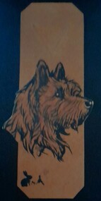 Hymettus Cottage & Garden Ballarat
Functional object - Bookmark, Scotty dog crafted bookmark
One of a group being an example of home art-craft work in the form of a bookmark popular in 1935, with Christmas Greetings inscribed on the reverse. Seasons Greetings written on the reverse with names, Melbourne address and the date of 1935.art board, craft, bookmark -
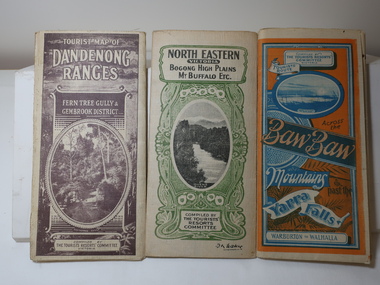 Kiewa Valley Historical Society
Maps - Tourist
These maps were all dated 1933 which was before the construction of the Kiewa Hydro Electric Scheme and when Tawonga was spelt Towonga. North East Victoria in 1933 was before the construction of the Kiewa Hydro Electric Scheme so the townships of Mt Beauty and Bogong are not shown. The description of the Snow Lines was important as skiers, bushwalkers and campers relied on them. The details on the map include "ADB. Numbered from A.1-377 round plates. CD Numbered from C 1-235 square plates. Poles about 3 chains apart 27 to the mile." 3 Tourist location maps (folded) and printed on parchment. 1. Tourist map of the Dandenong Ranges. Brown cover. dated 6-4-33. Govt. printer showing roads, tracks in red and heights of the land. 2. Tourist Map of Warburton, Mt Baw Baw, and Walhalla. Blue and Orange cover. dated 23-5-33 Govt. printer. 3 different maps of each area showin roads, tracks and timber tramways.Also in red and blue. 3. Tourist Map of North Eastern Victoria including Bogong High Plains Mt Buffalo Etc. Green cover. dated June 1933 Govt. printer. Main map and insert titled Bogong High Plains. Showing roads , tracks and tram ways. On insert showing snow poles. Also Red and Blue and mountains.By Authority of H.J. Green - 6 pence. Dept of Lands and Survey, Melbourne1933 maps, tourism maps, bogong high plains map 1933, snow poles -
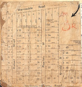 Ringwood and District Historical Society
Map, Residential Subdivision Allotment Layout on Mullum Mullum Road, Hobart Street, Paxton Street, Arnold Street and Warrandyte Road, Ringwood, Vic. circa 1920
One of 3 unrelated land subdivision maps on cardboard backing.H.C. Crouch, Licensed Surveyor, 443 Lt Collins Street, Melbourne. -
 Stawell Historical Society Inc
Map, Department of Lands & Survey J. Noone, Township of Heatherlie. Parish of Baroka. County of Borung 1888, 1888
Stawell & Grampians Freestone Quarry Company Railway Reserve. Cross & masons Quarry Site. Mamnager'sHouse, Stead's boarding House Stawell and Grampians railwaySurveyed Township Showing Quarry and railway Reservephoto Lithographed at the Department of lands and Survey Melbourne By J Noone 15.6.88railway quarry -
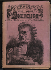 Federation University Historical Collection
Newspaper, Australasian Sketcher, 30 June 1884 to 01 November 1888, 1883 and 1888
Two copies of the Austakasian Sketcher with Pen and Pencil .1) 30 June 1884 Includes articles on Archbishop Moran, Children's Hospital, Sherbourne Sheppard obituary, the Tichborne case Includes images of the Most Reverand P.F. Moran, Catholic Archbishop of Sydney, New Sandridge Dock, Cricketing news from home, sketches from the Children's Hospital, View of Napier New Zealand, F. Mills New Warehouse Launceston, Grace Park .2) 01 November 1888 Articles include: Australian animals Images include: Cadbury's cocoa advertisement, A Flemington Picture, Railway Surveying Wangaratta to Mansfield, H.M.S. Nelson Leaving Sydney, New Prince's Bridge, Wilson Hall, Victoria before gold, Fawkner's First Printing Office, Government House Melbourne, Sandridge, Hobson's Bay, Old Supreme Court Melbourne, Melbourne Town Hall, Ballarat in the 50, Geelong in 1840, Ballarat Church of Engand Cathedral, Melbourne Exhibition Building, Flemington Racecourse, the Australian Club, Sir Anthony Musgrave, Fisheries Court at the Centennial Exhibition; Professor Neumayer, Antarctic Exploration, Melbourne Town Hall Organmelbourne international exhibition -
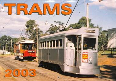 Melbourne Tram Museum
Ephemera - Calendar, Topmill Pty Ltd, "Trams - 2003", 2002
Wall Calendar - heavy card covers, 12 gloss art pages inside, titled "Trams - 2003" containing full colour photographs of Brisbane, Bendigo, Auckland, Sydney, Melbourne, Hobart, Adelaide and Christchurch. W7 1024 has a Lufthansa colour scheme. Has a punched hole along the top edge to enable wall use. Provides dates for holidays, school holidays and Pension payment days and phases of the moon. Produced by Topmill Pty Ltd and distributed by Gordon & Gotch Pty Ltd. Photos by Lawrie Hort, Hugh Ballment, Les Horsburgh, A. W. Perry, Ken Smith, and Colin Loach.trams, tramways, ballarat, bendigo, melbourne, adelaide, sydney, brisbane, auckland, hobart, christchurch, tram 104, tram 180, tram 111, tram 411, tram 1024 -
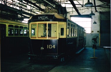 Melbourne Tram Museum
Photograph - Set of 18 colour photographs, Mike Ryan, late 1990's
Set of 18 colour photographs of the Melbourne Heritage fleet in storage at Preston Workshops, late 1990's. Photographed by Mike Ryan. Printed on Agfa paper. .1 - L104 .2 - L106 .3 - L106 .4 - HTT 8 .5 - V214 .6 - V214 interior .7 - V214 side view .8 - end seat of V214 .9 -W380 .10 - W1 431 .11 - Y469 .12 - W2 510 .13 - Y1 613 .14 - Y1 613 .15 - external view of Preston Workshops looking south .16 - external view .17 - external view .18 - external viewtrams, tramways, melbourne, mmtb, museum, tramcars, preston, tram l104, l106, htt 8, v 214, w380, w1 431, y469, w2 510, y1 613 -
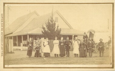 Bacchus Marsh & District Historical Society
Photograph, Cheese Factory Waddell Street Bacchus Marsh 1883
The Cheese Factory in this image was opened around 1879 by Mr. G.G. Pearce. It was in Waddell Street. It was one of the first cheese factories in Victoria. It was later owned and operated by William Telford with the assistance of John Mahon. The factory was described in the Bacchus Marsh Express newspaper as an important business and service for the region. G.G. Pearce was reported to have spent a good deal of money in setting up the factory to ensure it was one which produced high quality cheese using modern methods of production. The factory was sold in 1889 to a Mr. H. W. King who was from Abbotsford in Melbourne. Unfortunately within a few days of Mr King buying the factory it was completely destroyed in a fire. All that was left were two large pine trees and two large underground concrete tanks.G.G. Pearce was described as a pioneer of cheese factories in Victoria. His first factory was just outside of Bacchus Marsh at Hopetoun. Around 1879 he moved into Bacchus Marsh and opened a new purpose built factory in Waddell Street. The Bacchus Marsh Express newspaper reported that no expense had been spared in constructing this factory. The factory was completely destroyed in a fire in 1889 which makes it fortunate that this image was captured of this early cheese factory in Victoria.Small sepia unframed photograph on card with gold border framing photograph. Housed in the album, 'Photographs of Bacchus Marsh and District in 1883 by Stevenson and McNicoll'. The image shows a group of men and women standing in a row in front of the Bacchus Marsh Cheese factory. One of the women is holding a small child. In front of another woman stands a young boy. Behind them is a covered wagon with a man seated upon it. Some of the men and women are wearing long aprons. In the background is the Cheese Factory. It is a large wooden structure with a high and steep pitched roof.On the front: Stevenson & McNicoll. Photo. 108 Elizabeth St. Melbourne. COPIES CAN BE OBTAINED AT ANY TIME. On the back: LIGHT & TRUTH inscribed on a banner surmounted by a representation of the rising sun. Copies of this Portrait can be had at any time by sending the Name and Post Office Money Order or Stamps for the amount of order to STEVENSON & McNICOLL LATE BENSON & STEVENSON, Photographers. 108 Elizabeth Street, MELBOURNE stevenson and mcnicoll 1883 photographs of bacchus marsh and district, cheese factories, bacchus marsh cheese factory -
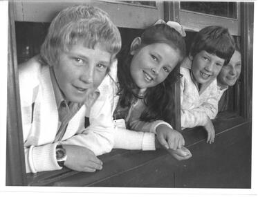 Melbourne Legacy
Photograph - Junior legatee outing, Camp 1976, 01/1976
A photo of 4 children leaning out from a train carriage windows. They were junior legatees travelling by train to attend a Legacy Camp. It came from an envelope with other camp photos. A newspaper article in the Herald on 10 January 1976 says the children were: Robert Bennett, his sister Anastasia Bennett and brother Patrick Bennett and a friend Debra Packwood as they arrived in Spencer Street Station enroute to Camperdown for a two week holiday organised by Legacy. The Legacy envelope was marked "P6 Junior Legatee Camps and Hols" in red pen, and dated Jan 1977 in pencil. The contents will be items 00418 to 00425. Melbourne Legacy provided camps for junior legatees - the children of deceased servicemen. The camps gave the children an opportunity of a summer holiday with other Legacy children.A record of Junior Legatee camps.Black and white photo of children looking out a train window on their way to Somers Camp.Handwritten on back "Jan 1976 on train (Hols)" in blue pen. Stamped "The Property of Melbourne Legacy" in purple ink. Stamped "Copyright The Herald and Weekly Times" in blue ink. junior legatee outing, trains, camp -
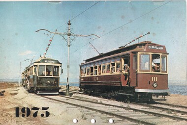 Ballarat Tramway Museum
Document - Calendar, Sydney Tramway Museum, 1974
Calendar 1975 - 28 pages - black and white photos except for the front cover. Produced by the Sydney Tramway Museum. Features photographs of various Australasian Tramway Systems: Ballarat 34 and Adelaide 111 at the St Kilda Tramway Museum Dunedin 61 Ballarat 37 at the City terminus Bulimba Power Station electric locomotive Newcastle 383 Darling St Balmain Perth Trolley Bus 21 Perth 55 Melbourne Tait train Launceston 26 Sydney Suburban train Adelaide 365 Brisbane 293 VR 28 Geelong 14 - at Eastern Park Sydney tramway museum tramways, trams, ballarat, adelaide, newcastle, sydney, dunedin tramways, brisbane, perth, trolley buses, melbourne, launceston, victorian railways, geelong, tram 14, tram 37, tram 34 -
 Flagstaff Hill Maritime Museum and Village
Book, The Plants Indigenous To The Colony of Victoria Vol 1-1
This book was part of a large group of books referred to as the Pattison Collection, which belonged to the Warrnambool Public Library, part of the Warrnambool Mechanics’ Institute. About RALPH ERIC PATTISON and the ‘PATTISON COLLECTION’ The ‘Pattison Collection’ is a collection of books and records that was originally owned by the Warrnambool Mechanics’ Institute, founded in Warrnambool in 1853. By 1886 the Warrnambool Mechanics’ Institute (WMI) had grown to have a Library, Museum and Fine Arts Gallery, with a collection of “… choice productions of art and valuable specimens in almost every branch and many wonderful national curiosities are now to be seen there, including historic relics of the town and district.” It later included a School of Design. Although it was very well patronised, the WMI was led to ask the City Council to take it over in 1911 due to lack of financial support. In 1935 Ralph Pattison was appointed as City Librarian to establish and organise the Warrnambool Public Library as it was then called. Ralph Eric Pattison was born in Rockhampton, Queensland, in 1891. He married Maude Swan from Warrnambool in 1920 and they set up home in Warrnambool. In 1935 when Pattison accepted the position as City Librarian for the Warrnambool City Council his huge challenge was to make a functional library within two rooms of the Mechanics’ Institute. He tirelessly cleaned, cleared and sorted a disarrayed collection of old books, jars of preserved specimens and other items reserved for exhibition in the city’s museum. He developed and updated the library with a wide variety of books for all tastes, including reference books for students; a difficult task to fulfil during the years following the Depression. He converted all of the lower areas of the building into a library, reference room and reading room for members and the public. The books were sorted and stored using a cataloguing and card index system that he had developed himself. He also prepared the upper floor of the building and established the Art Gallery and later the Museum, a place to exhibit the many old relics that had been stored for years for this purpose. One of the treasures he found was a beautiful ancient clock, which he repaired, restored and enjoyed using in his office during the years of his service there. Ralph Pattison was described as “a meticulous gentleman whose punctuality, floorless courtesy and distinctive neat dress were hallmarks of his character, and ‘his’ clock controlled his daily routine and his opening and closing of the library’s large heavy doors to the minute.” Pattison took leave from 1942 to 1945 to serve in the Royal Australian Navy, Volunteer Reserve as Lieutenant. A few years later he converted one of the Museum’s rooms into a Children’s Library, stocking it with suitable books for the younger generation. This was an instant success. In the 1950’s he had the honour of being appointed to the Victorian Library Board and received more inspiration from the monthly conferences in Melbourne. He was sadly retired in 1959 after over 23 years of service, due to the fact that he had gone over the working age of council officers. However, he continued to take a very keen interest in the continual development of the Library until his death in 1969. THE NEW WARRNAMBOOL LIBRARY When the WMI building was pulled down in 1963 a new civic building was erected on the site and the new Warrnambool Library, on behalf of the City Council, took over all the holdings of the WMI. At this time some of the items were separated and identified as the ‘Pattison Collection’, named after Pattison. Eventually, the components of the WMI were distributed from the Warrnambool Library to various places, including the Art Gallery, Historical Society and Flagstaff Hill. Later some were even distributed to other regional branches of Corangamite Regional Library and passed to and fro. It is difficult now to trace just where all of the items have ended up. The books at Flagstaff Hill Maritime Village generally display stamps and markings from Pattison as well as a variety of other institutions including the Mechanics’ Institute itself. WARRNAMBOOL'S MECHANICS' INSTITUTE Warrnambool's Mechanics' Institute (or Institution as it was sometimes called) was one of the earliest in Victoria. On 17th October 1853 a meeting was held where it was resolved to request the Lieutenant Governor of the Colony to grant land for the erection of a Mechanics' Institutes building. A committee was formed at the meeting and Richard Osburne chaired the first meeting of this committee. The land on the North West corner of Banyan and Merri Streets was granted but there were no funds to erect the building. The Formal Rights of the Warrnambool Mechanics' Institute's encompassed its aims and these were officially adopted in1859; "This Institution has for its object the diffusion of literary, scientific, and other useful knowledge amongst its members, excluding all controversial subjects, religious or political. These objects are sought to be obtained by means of a circulating library, a reading room, the establishment of classes, debates, and the occasional delivery of lectures on natural and experimental philosophy, mechanics, astronomy, chemistry, natural history, literature, and the useful and ornamental arts, particularly those which have a more immediate reference to the colony." The Warrnambool Mechanics' Institute opened its first reading room in November1884 in the National School building at the corner of Banyan and Timor Streets. The Institute was funded by member subscription, payable on a quarterly, half yearly or yearly basis. Samuel Hannaford, the Manager of the Warrnambool Bank of Australasia, was the first Honorary Secretary of the Mechanics' Institutes, and an early President and Vice-President. He also gave several of the early lectures in the Reading Room. Another early Secretary, Librarian and lecturer was Marmaduke Fisher, the teacher at the National School. Lecture topics included The Poets and Poetry of Ireland', 'The Birth and Development of the Earth', 'The Vertebrae - with Remarks on the pleasures resulting from the study of Natural History' and 'Architecture'. In 1856 the Reading Room was moved to James Hider's shop in Timor Street, and by 1864 it was located in the bookshop of Davies and Read. In the 1860's the Mechanics' Institute struggled as membership waned but in 1866, after a series of fund raising efforts, the committee was able to purchase land in Liebig Street, on a site then called Market Square, between the weighbridge and the fire station. A Mechanics' Institute building was opened at this site in August 1871. The following year four more rooms were added to the main Reading Room and in 1873 the Artisan School of Design was incorporated into the Institute. The same year Joseph Archibald established a Museum; however it deteriorated when he was transferred to Bendigo in 1877. In 1880, with Archibald's return to Warrnambool, the Museum was re-established, and in 1885 a new building was built at the back of the Institute to accommodate the re-created School of Design, the Art Gallery and the Museum. In 1887 the Museum section was moved to the former court house in Timor Street (for some time the walls of the building formed part of the TAFE cafeteria but all is now demolished)). In 1911 the Museum was transferred back to the original building and the management of the Mechanics' Institute was handed over to the Warrnambool City Council. The Museum and Art Gallery became one and housed many fine works of art, and the Library continued to grow. The building was well patronised, with records showing that at the beginning of the 20th century there were between 500 and 800 visitors. During World War One the monthly figures were in the thousands, with 3,400 people visiting in January 1915. The Museum was a much loved Institution in Warrnambool until the contents of the Museum and Art Gallery were removed to make room for the Warrnambool City Council Engineers' Department. The contents were stored but many of the items were scattered or lost. When the original building was demolished the site became occupied by the Civic Centre, which included the new City Library. (The library was temporarily located in the old Palais building in Koroit Street.) In the process of reorganisation the Collection was distributed amongst the community groups: -The new City Library took some of the historic books and some important documents, historic photographs and newspapers. -The Art Gallery kept the 19th Century art collection and some of the artefacts from the museum. -The Historic Society has some items -The State Museum has some items -Some items were destroyed -Flagstaff Hill Maritime Village has old newspapers, Government Gazettes, most of the Mechanics' Institute Library, ledgers and documents connected to the Mechanics' Institute Library, some framed and unframed art works and some photographs. The Warrnambool Mechanics' Institute Library book collection is deemed to be of great importance because it is one of the few collections in an almost intact state, and many of the books are now very rare and of great value. The Pattison Collection, along with other items at Flagstaff Hill Maritime Village, was originally part of the Warrnambool Mechanics' Institute’s collection. The Warrnambool Mechanics’ Institute Collection is primarily significant in its totality, rather than for the individual objects it contains. Its contents are highly representative of the development of Mechanics' Institute libraries across Australia, particularly Victoria. A diversity of publications and themes has been amassed, and these provide clues to our understanding of the nature of and changes in the reading habits of Victorians from the 1850s to the middle of the 20th century. The collection also highlights the Warrnambool community’s commitment to the Mechanics’ Institute, reading, literacy and learning in the regions, and proves that access to knowledge was not impeded by distance. These items help to provide a more complete picture of our community’s ideals and aspirations. The Warrnambool Mechanics Institute book collection has historical and social significance for its strong association with the Mechanics Institute movement and the important role it played in the intellectual, cultural and social development of people throughout the latter part of the nineteenth century and the early twentieth century. The collection of books is a rare example of an early lending library and its significance is enhanced by the survival of an original collection of many volumes. The Warrnambool Mechanics' Institute’s publication collection is of both local and state significance. The Plants Indigenous To The Colony of Victoria Vol 1-1 Author: Ferdinand Mueller Publisher: Government Printer Melbourne Date: 1860-1862 Further Information: John Ferres Government PrinterThe label on spine cover with typed text PAT F 580 MUE Paste down front end paper has a sticker from Warrnambool Mechanics Institute and Free Library Front loose end paper has a sticker from Corangamite Regional Library Service Flyleaf has a stamp from Corangamite Regional Library Serviceflagstaff hill, warrnambool, shipwrecked coast, flagstaff hill maritime museum, maritime museum, shipwreck coast, flagstaff hill maritime village, great ocean road, book, pattison collection, warrnambool library, warrnambool mechanics’ institute, ralph eric pattison, corangamite regional library service, warrnambool city librarian, mechanics’ institute library, victorian library board, warrnambool books and records, warrnambool children’s library, the plants indigenous to the colony of victoria vol 1-1, ferdinand mueller -
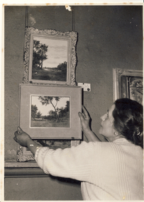 Kew Historical Society Inc
Photograph, The Age, Kew Arts Festival Exhibition, 1944-1951
The Melbourne artist Alma Agnes Marion Figuerola, was the daughter of Juan Pedro Narciso Figuerola (1869-1919) and Alice Lucinda Walker Hanson (1889-1969). Each of their three daughters grew up to be involved in the arts: Alma as a painter; Carmen Irene (1906-1993) as a short story writer, poet and teacher of dancing; and Sylvia (also Silvia) Lyla Alice (1911-1992) as a composer and cellist. The first art lessons Alma Figuerola received were with Oscar Binder. Later she attended the art school established by the Melbourne 'tonalist' [Duncan] Max Meldrum (1875-1955). She graduated from his school in 1920, participating in her first group exhibition in the same year. Solo exhibitions of her work were to be held in 1933 at the Meldrum Gallery in Elizabeth Street, in 1937 and 1945 at the Athenaeum Gallery at 188 Collins Street, and in 1951 at Georges Gallery in Collins Street. Throughout her extensive career she participated in group exhibitions, usually with artists of the Meldrum School, and as a member of the Twenty Melbourne Painters, of which she was invited to become an associate in 1935. In 1953, her portrait of Professor ES Hills was entered in the Archibald Prize Competition of the Art Gallery of New South Wales. A resident of Kew from the 1930s - 51 Studley Park Road, often with her mother, her sister Carmen, or both - from c.1942 until her death she lived at 'D’Estaville', 7 Barry Street. From the late 1930s she is recorded as actively contributing to the arts at a local level. In 1939 and 1940 she participated in art exhibitions at the Hawthorn Municipal Library organised by Jessie Carbines. From 1944 to 1951 she co-organised successive Kew Arts Festivals, initially in the Presbyterian Church Hall in Highbury Grove and later at the Recreation Hall in Wellington Street. A foundation member of the Kew Historical Society in 1958, Alma Figuerola remained an active member of the Society until her death on 8 December 1970. She predeceased her two sisters who both died in the 1990s and who are buried at Andersons' Creek Cemetery in Warrandyte.An undated photograph of Alma Figuerola and an as yet unidentified man hanging paintings for an art exhibition at one of the Kew Arts Festivals held between 1944-51.On reverse, handwritten "4583 Alma Figuerola" Photographer stamp" Copy Right This photograph may not be reproduced without permission in writing from the Editor of "The Age", *** Collins Street, Melbourne, and Pitt Street, Sydney"alma figuerola album, arists - kew (vic), art exhibitions - kew (vic) -
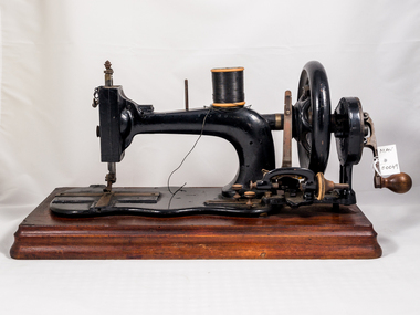 City of Moorabbin Historical Society (Operating the Box Cottage Museum)
Functional object - Wertheim Sewing Machine, c1880
Hugo Wertheim (1854–1919) arrived in Melbourne in 1875. He became a successful agent for sewing machines manufactured by his father’s cousin Joseph Wertheim in Frankfurt, Germany. Hugo married Joseph’s daughter Sophie Emilie and they settled in Melbourne. Hugo made many trips back to the main factory in Germany and, with extensive advertising, established a thriving business for sewing machines, bicycles, pianos under various ‘brand names’ - Wertheim, Electra, Planet, Griffin, Hapsburg. It has been said that Dame Nellie Melba preferred a Wertheim piano for her performances. In 1908 Hugo opened a large piano factory in Bendigo St Richmond, Victoria. His son Herbert maintained the business until the factory closed in 1935.The pioneer settlers and market gardeners of Moorabbin Shire had to be self reliant and made their own clothing and utensils. This sewing machine was one of many items they used to exhibit the skill and craftsmanship of the women in these families. A sewing machine was a necessary part of each home.A Wertheim hand–crank sewing machine c1880. The hand machine was operated by turning the handle. The hand machine could also be fitted to a stand with table and draws, the machine could then be used by hand or foot. This type of sewing machine was widely used in many homes, in an era when hand-made clothes were the “norm”, and clothes were mended, or ‘re-made’ into another garment 'WERTHEIM' across body of machinemelbourne, clothing, brighton, moorabbin, germany, piano, pioneers, richmond, bentleigh, dressmaking, market gardeners, early settlers, craftwork, sewing machines, wertheim hugo, wertheim joseph -
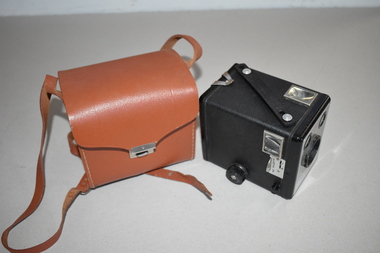 Warrnambool and District Historical Society Inc.
Brownie Flash 11 Camera and Case, Frank Carew & Co, Late 1950s
Box Brownie cameras were first produced early in the 20th century by the Eastman Kodak company in U.S.A. They were bought by amateur photographers and were very popular because they were easy to use and affordable for the average householder. The Brownie Flash 11 camera was produced by the Australian Kodak company in Melbourne from 1958 to 1963. 500,000 of these cameras were made during that time. This camera and case are retained as they are good examples of a box Brownie camera made in Australia in the late 1950s and early 1960s..1 This is a box camera with a metal body and a synthetic leatherette covering. It has a horizontally-striped front panel and two glass finders. It also has metal pin and screw flash contacts and a built-in close-up lens. It has a leatherette strap. .2 This is a light brown leather/latex case which is rectangular-shaped with a curved top, a metal catch and a shoulder strap with a metal buckle. The case contains a small booklet with information on how to use the camera. .1 Kodak Kodet lens Brownie Flash 11 Camera Kodak Australasia Pty Ltd Melbourne Australia Close Up .2 Made for Kodak (A/asia) Pty Ltd by Frank Carew & Co, Northcote, Vic Reprocessed leather/latex vintage cameras, history of warrnambool -
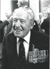 Melbourne Legacy
Photograph - Photo, Anzac Day 1993, 1993
According to the paper label "Over 300 Legatees participated in the ANZAC Day march commemorating Legacy's 70th Anniversary." Photos show three Legatees assembling in Flinders Street before the march, and a close up of Legatee Ron Austin. Ron Austin was the last surviving World War 1 veteran alive involved with Melbourne Legacy. (See also 00754, 00755 and 00756). The article in The Answer in May 1993 says: The ever-smiling L/ Ron Austin is an inspiration for all. Ron has the distinction of being the youngest surviving Melbourne Legatee to have served in WW1. He joined over 300 Legatees to march as part of the Legacy contingent to mark Legacy's 70th anniversary, and he marched again for a a few blocks as he joined members of his wireless unit to catch up with old friends. Ron was just 14 and a half when he joined the R.A.N. in 1917 as a Boy Seaman. He served for 10 years, resumed civilian life, then in 1931 joined the RAAF Telecommunications. WWII kept him busy! In 1949 he became Assistant Air Attache in Washington, D.C. Ron retired from the Service in 1955 as Wing Commander. It comes as no surprise that Ron was awarded an O.B.E. for his tireless devotion to duty and you might sense Ron has been a tireless member of Legacy too." Plus a note in the Answer in 1997 after Ron passed away aged 94.A record of Legatees marching together on Anzac Day to commemorate the 70th Anniversary of Legacy.Black and white photo x 2 of Anzac Day March 1993 and an article from The Answer on Ron Austin.Marked B10, and B16 which are the frame numbers from the B proof sheet (00754.2). 00788.1 says "L'tee Ron Austin last WWI veteran alive in Melbourne Legacy" in blue pen.70th anniversary, anzac day, answer, ron austin -
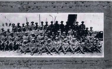 Lara RSL Sub Branch
Photograph of A Company 2/21st Battalion Australian Infantry, c July to September 1940
Black and White photo Company "A" 2/21Rare item of historical value due to the battallion being taken prisoner by Imperial Japanese soldiers at Ambon. The Australians suffered at the hands of their captures.Photograph of members of " A" Company 2/21st Battalion Australian infantry Taken in Melbourne. Vic. Group portrait of A Company, 2/21st Battalion. Left to right: front row: Chafer, Hartley, Bailey, Fisher, Breen, Marsh, Lance Corporal (L Cpl) Billings, Smith, Knuckey, McKenzie, Wilson, Dallagh, Jones, Redwood, Turnbull, Rutley, Minetti, Gravener and Corporal Borr (?). Second row: Winter, Brander, M.F. Osborne, V.F.H. Hubbard, Gladigou, Alison, Davies, Blair, Edney, Tuddenham, B. Tucker, Sergeant (Sgt) Stanbridge, Captain (Capt) Wesley, Lieutenant (Lt) Thomas, Sgt Stayte, Beachley, Hallowell, A. Osborne, Thatcher, Watson, unidentified, Ericson, Hadlow, Tucker, McGregor, C.R. O'Bryan and Bradley. Third row: Walker, R.R. Hubbard, Hutchins, L Cpl Kirwan, Mason, J.M. Francis, Corson (?), Leslie, Dunbar, Arnold, Inkster, Balcombe, Corporal Leary, Beckwirth, Barclay, Blanks, Conway, Bolwell, Rigney, Orange, Taylor, Dihood, Mitchell, Donchi, Howard, Flintoff, Hill, Capon, Lewin, L Cpl Eouid (?), Sgt Jacobs. Fourth row: Sgt Seabrooke, Privates King, Jorgenson, O'Halloran, Simmons, Amesbury, Kofoid, Daff, L Cpl Guest, Cooke, Ordish, Stratton, three cooks named Keel, Tullett and Brown, Privates Turner, Dahlberg, Uren, Ansett, Moran, Fry, Penny, Phillips, Lock, Loch, Perrin, Snodgrass, Argus, Gee, Corp Boyce.Photo and frame A Coy 2/21 with names inscribed there on. Black ans white photo by H.M. Walker, Wentworht House, 203 Collins Street, Melbourne.a coy 2/21 battallion -
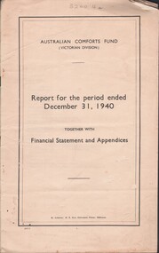 Bendigo Historical Society Inc.
Document - LYDIA CHANCELLOR COLLECTION: AUSTRALIAN COMFORTS FUND REPORT
(i) Report for the period ended December 31, 1940. Together with Financial Statement and Appendices. Australian Comforts Fund (Victorian Division). By Authority : H.E. Daw, Government Printer, Melbourne. 24 pgs.(ii) Second Annual Report. Together with Financial Statement and Appendices for the Year ended December 31, 1941. Australian Comforts Fund (Victorian Division). By Authority: H.E. Daw, Government Printer, Melbourne.organization, club / society, australian comforts fund, lydia chancellor, collection, australian comforts fund, war, world war 11 -
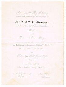 Bendigo Historical Society Inc.
Document - INVITATION FOR WEDDING OF MARLENE SCHILLING AND NEVINSON ANDREW DWYER 20.6.1956
Silver printed cream coloured card INVITATION FOR WEDDING OF MARLENE SCHILLING AND NEVINSON ANDREW DWYER 20.6.1956. Mr & Mrs SCHILLING request the pleasure of the company of Mr & Mrs G Deanau at the marriage of their daughter Marlene with NEVINSON ANDREW DWYER at Melbourne Grammar school chapel Domain Rd South Yarra on Wed 20.6.1956 and afterwards at Ciro's Collins Pl , Melbourne , 5 Newbay Crescent Brighton.ephemera, mementoes, celebrations, marlene schilling and nevinson andrew dwyer /mr & mrs g deanau -
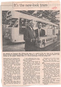 Ballarat Tramway Museum
Newspaper, "Its the new-look tram", 24/03/1973 12:00:00 AM
Newspaper Clipping from a Melbourne newspaper, 24/3/1973 about the construction of a new trams for Melbourne. Has a photo of the Minister for Transport, Mr. Wilcox and Mr. S. Bramich, an electrical engineer at Preston with a model of the prototype and 1041 under construction in the background. Quotes Mr. Kirby that the Board would like to recruit women drivers, the recent approval to call tenders for the construction of 100 new trams."24/3/73" in red ink in top right hand corner.trams, tramways, mmtb, women drivers, new trams, preston workshops -
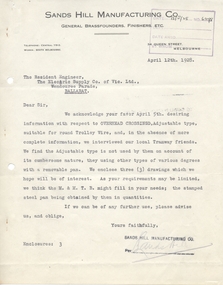 Ballarat Tramway Museum
Document - Letter/s, Sands Hill Manufacturing Co, 12/04/1928 12:00:00 AM
Yields information about the manufacture of brass overhead crossings and the complex ones ESCo were using compared to the MMTB.Letter dated 12/4/1928 from the Sands Hill Manufacturing Co, General Brass founders, Finishers Etc of 34 Queen St Melbourne to The Resident Engineer, ESCo, regarding the Overhead Crossing, Adjustable type for round Trolley Wire, forwarding three drawings of fixed type used by the MMTB in Melbourne and stamped steel pans. Typed on Mount Royal Bond Made in Canada paper.trams, tramways, overhead, points, trolley wire, esco -
 Ballarat Tramway Museum
Document - List, Wal Jack, "Mileages", 1950's
Yields information about the mileages of the Ballarat tram fleet in other cities, prior to coming to Ballarat.Handwritten list of SEC Ballarat Tramcars and their mileages in the other cities prior to coming to Ballarat. Aligns with the list on the previous page. Gives their Melbourne or Adelaide numbers and their mileage in Melbourne, Adelaide or Geelong. For some the bogie trams, also gives the date they left Preston Workshops. Prepared by Wal Jack Contained within Reg Item 5507 - Foolscap binder with green covers, black binding edge and metal clips. tramcars, livery, sec, esco -
 Melbourne Tram Museum
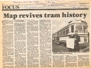
Newspaper, The Leader, "Map revives tram history", 31/03/1993 12:00:00 AM
Newspaper cuttings from The Leader, 31/3/1993, titled "Map revives tram history", about the launch of a printed map or poster giving the history of Melbourne's trams. See Reg Item 506 for the actual item. Article by Shane Jenkins provides snippets of history from the map or poster. Has a photo of the author, Stephen Watson standing alongside W6 964 with Bank of Melbourne adverts.Along the top edge, notes for Keith about the cutting, from Jan.trams, tramways, maps, publications, posters, tram 964 -
 Melbourne Tram Museum
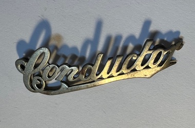
Badge - Conductor, Stokes & Sons, 1910s
Used by tramways to indicate the position of the person to a passenger or another employee. Most likely made as a general production item by Stokes for tramways and railways.Demonstrates an item made to indicate the wearer's position of the tramway employee.Uniform Badge for a "Conductor". Manufactured by Stokes and Sons, Melbourne. Made from a cast brass item and then nickel plated. Cast in the form of the handwritten or script word/s and underlined and rounded to fit on a cap. On the rear, silver soldered on are two brass loops at either of the badge to enable to be sewn or fitted with clips onto a cap. On the back of the back of the badge in very small letters is the name of the manufacturer - Stokes & Sons / Melbourne. tramways, trams, cap badge, hat badge, uniforms -
 Bendigo Historical Society Inc.
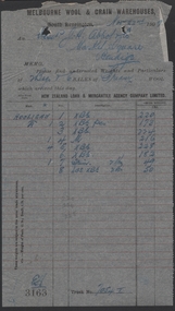
Administrative record - Abbott Collection: 29 letters/notes/correspondence from July to Dec 1909, from business and Victorian Government Officers; addressed to J.H. Abbott & Co
29 letters/notes/correspondence, and 1 invoice; from July to Dec 1909, from business and Victorian Government Officers; addressed to Mr. J.H. Abbott 29 letters/notes/correspondence and one 1909 invoice; from July to Dec 1909, from business and Victorian Government Officers; addressed to J.H. Abbott often as MLC in office. Many with Victorian Parliament House, Melbourne letterhead One invoice from the Melbourne Wool & Grain Warehouses, 22 Nov 1919, for a range of goods (for 2 bags & 6 bales of greasy wool, detailed in 8 items)company invoices and business correspondence, official parliament correspondence -
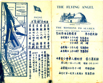 Mission to Seafarers Victoria
Flyer, Victorian Seamen's Mission, The Flying Angel, 1963-1966
The Mission accommodated seamen from all nationalities from the earliest days of operation. Asian seafarers are recorded visiting the Mission from the late 19th C. onwards. The first Chinese chaplain to be appointed was Rev Steven Wong who moved to Melbourne in the 1960s. Rev Wong served from 1963-1966 and according to his sons helped design these information brochures. Images of Rev'd Wong are included in the VC Database. The pamphlet gives days and times of activities such as dances and films and chapel services. The Chinese writing was made by Reverend Stephen WongA rare surviving period example of a non-english speaking flyer on information about the Mission to Seafarers Victoria Commercially printed paper single fold flyer providing directions and information to the Central Club, Missions to Seamen at Flinders St extension, in Mandarin. Contains a drawing of the central mission and a map of Docklands.In English: CENTRAL CLUB/THE MISSIONS TO SEAMEN, FLINDERS STREET EXTENSION, MELBOURNE C.3 In Mandarin: Translation (from Google translate): date and time of services / date and time for dances, movie sessions, teareverend stephen wong, mandarin, chinese, asian, reverend perry mitchinson