Showing 10465 items
matching plan
-
 Kew Historical Society Inc
Plan - Saxonwood Estate, Doncaster [East]
Subdivision plans and real estate flyers/brochures reveal a number of aspects of urban development and history. The Kew Historical Society's collection of these plans, as well as advertisements extracted from magazines, cover key aspects of community development and architectural history of Kew and Kew Eat as well as surrounding suburbs. While most of the plans in the collection were gifted to the Society by the former City of Kew, a number of other plans and advertisements have been donated by individuals, of which this is an example.Undated, multi-page subdivision plan advertising lots for sale bounded by Blackburn Road, George Street, Windermere Avenue, and Saxonwood Drive in what is currently Doncaster East. Other streets in the subdivision include: Mowbray Court, Stafford Court, Rugby Court, and Robin Hood Court. The front page includes a Birdseye view of the estate which identifies existing and projected civic amenities, as well as the estate's relationship to surrounding suburbs and the city centre. Red crosses on the detailed plan of lots on page two indicate those that have been sold. The final page includes a locality plan. saxonwood estate -- doncaster east (vic.), subdivision plans -- doncaster east (vic.) -
 Ringwood and District Historical Society
Newspaper, Scrapbook Clipping, Library Collection, Ringwood, Victoria, `
``Newspaper clipping from "The Post", 21-7-93, P 3. NEWS Watch - Council calls for school plan details The policy and resources committee has recommended Ringwood Council call on Education Minister Don Hayward to outline plans for Ringwood schools. Councillor Chris McRae moved that council ask Mr Hayward to outline plans for amalgamations and closures and consult with council.` -
 Port Melbourne Historical & Preservation Society
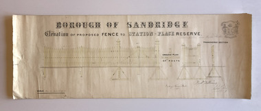
Plan, Charles Clay, Borough Surveyor, Elevation of Proposed Fence to Station Place Reserve, c. 1881
Although undated, the plan is probably from 1880-81. The plan is signed by Charles CLAY, Fred WILLIAMS and Witney Henry BATES. Charles CLAY was the Borough Surveyor from 1860 to 1884. Fred WILLIAMS was a Councillor 1875 to 1886 and served as Mayor, 1880-81. It is not known who Witney Henry BATES was. A note in pencil, probably added later, indicates the fence was between Graham and Bridge Streets.Undated Borough of Sandridge hand-drawn plan for a proposed picket fence at Station Place Reserve.'between Graham and Bridge Streets' handwritten in pencil below and to the right of the main title.local government - borough of sandridge, engineering - fences, charles clay, witney henry bates, frederick williams -
 Port Melbourne Historical & Preservation Society
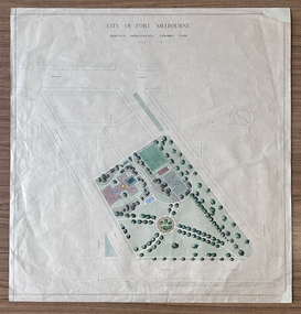
Plan - Edwards Park improvements (Trugo Green), Port Melbourne, 1940s - 1950s
Although undated, this plan is probably from the late 1940s or early 1950s. Around this time Port Melbourne Council were looking to built a basketball court in Lagoon reserve, and shelters and a senior citizen's clubhouse in Edwards Park. PMHPS does to believe the basketball court shown in the plan was built but the Port Melbourne Senior Citizens and Trugo Club is at the location shown on the plan. A shelter is in a similar location to the one on the plan. A children's playground existed in that location shown in a photograph from the 1930s. The round flowerbed where the paths cross in the centre of the park in not in the 1930s photograph but is a current feature of Edwards Park.Plan drawing to scale, hand coloured, of proposed improvements to Edwards Park (Trugo Green), undated possibly late 1940s or early 1950s."City of Port Melbourne"built environment - recreational facilities, parks and gardens, sport - trugo, port melbourne trugo club, edwards park -
 Mission to Seafarers Victoria
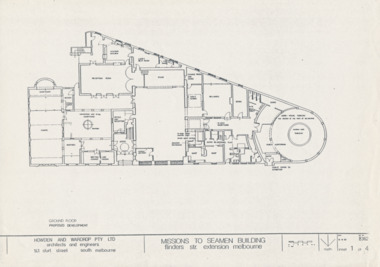
Drawing - Architectural drawings, Howden & Wardrop Pty Ltd, Mission to Seamen Building, 1983
3 of the 4 plans by Howden and Wardrop Pty Ltd part of their 1983 report for renovations. They were made from the T. Howes and P. Demetrios plans which were their submission for the Mathew Flinders Measured Drawing Competition as mentioned in the report.A4 copies of original planshowden and wardrop pty ltd, 1983, vhr 1496, t. howes, p.demetrios -
 Ballarat Heritage Services
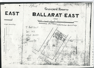
Digital photograph, Graveyard Reserve, Ballarat East
Ballarat East, Section 103, Allotment 21 & 22, Peake and Tress Streets, Mount Pleasant. Surveyed by W. S. Reeves Contract Surveyor April 14th, 1871. Also shows allotments of T. Williams and F. Macalpin, as well as the Powder Magazine Reserve.Plan of the Graveyard Reserve and Mount Pleasant Powder Magazine.mount pleasant, w.s. reeves, plan, powder magazine, t. williams, f. macalpin -
Kew Historical Society Inc
Plan - Pointed Firs Estate, Camberwell North, 1936
Subdivision plans and real estate flyers/brochures reveal a number of aspects of urban development and history. The Kew Historical Society's collection of these plans, as well as advertisements extracted from magazines, cover key aspects of community development and architectural history of Kew and Kew Eat as well as surrounding suburbs. While most of the plans in the collection were gifted to the Society by the former City of Kew, a number of other plans and advertisements have been donated by individuals, of which this is an example.Original multi-page sales brochure of the Pointed Firs Estate, advertised as located in Camberwell North, but now in Balwyn North. The 4-page bifold brochure includes promotional material as well as a detailed plan of the 28 lots for sale, a photograph of the locality with the plan overlaying it, as well as aerial photos and street views. The estate included lots in Doncaster Road, Thackeray Street, Houghton Street, an dMaud Street. pointed firs estate -- balwyn north, subdivisions -- balwyn north (vic.) -
Port Melbourne Historical & Preservation Society
Plan - Alternative Layouts for Fishermans Bend, J C Morrell, Jun 1920
Published 1920 by PMCC but first presented at the 1st Australian Town Planning Conference, Adelaide 1917.Two alternative plans for Fishermen's Bend, proposing harbour improvements and layout of suburbs and industrial areas. First presented 1917.fishermans bend, town planning - proposals shelved, j c morrell -
 Kew Historical Society Inc
Plan - Subdivision Plan, Central Park Estate, Deepdene - Camberwell, 1923
The Kew Historical Society collection includes almost 100 subdivision plans pertaining to suburbs of the City of Melbourne. Most of these are of Kew, Kew East or Studley Park, although a smaller number are plans of Camberwell, Deepdene, Balwyn and Hawthorn. It is believed that the majority of the plans were gifted to the Society by persons connected with the real estate firm - J. R. Mathers and McMillan, 136 Cotham Road, Kew. The Plans in the collection are rarely in pristine form, being working plans on which the agent would write notes and record lots sold and the prices of these. The subdivision plans are historically significant examples of the growth of urban Melbourne from the beginning of the 20th Century up until the 1980s. A number of the plans are double-sided and often include a photograph on the reverse. A number of the latter are by noted photographers such as J.E. Barnes.An agent’s board on which parts of an advertisement for the Central Park Estate have been pasted. [The State Library of Victoria holds a complete plan]. Whereas the original plan included black and white photographs and effusive prose about the virtues of the Estate, the item in our collection includes only the actual blocks. The agent has annotated particular blocks to indicate that they have been sold.subdivision plans - deepdene - camberwell, central park estate -
Greensborough Historical Society
Document - Digital Image, Marilyn Smith, Greensborough Secondary College Gr8750 Refurbishment Plans 2016, 2016_03
This document shows the plan and finance for a refurbishment of Greensborough College 2016-2017.Digital copy of planning documentgreensborough college -
 Wodonga & District Historical Society Inc
Album - Hume Reservoir Australia Album - Plans and Progress Photos - River Murray Water Scheme, Department of Public Works, N.S.W, 1927
This set of photos is from a leather bound album bearing the inscription "HUME RESERVOIR AUSTRALIA" plus 'The Rt. Hon. L. C. M. S. Amery, P. C., M .P.' all inscribed in gold. It was presented to The Rt. Hon. L. C. M. S. Amery, P. C., M. P, Secretary of State for Dominion Affairs on the occasion of his visit to the Hume Reservoir on 2nd November 1927. This album is of local and national significance as it documents the planning and development of the Hume Reservoir up to 1927. It was the largest water reservoir in the British Empire. The album records the pioneering engineering work that went into its construction.1. Locality Plan and Plan of Dam. The dam is about ten miles by road upstream from Albury and about three-quarters of a mile below the confluence of the Mitta Mitta River and the Murray River. Its main features consist of a concrete portion across the bed of the river with earth embankment at both ends. The foundations throughout are on hard granite, found at an average depth of about 40 feet below the surface, the centre line being located to take advantage of the most favourable rock levels.Heading on page "WORKS UNDER RIVER MURRAY WATERS AGREEMENT/HUME RESERVOIR" Beneath top diagram "FIG. 1. ELEVATION" Beneath second diagram "FIG. 2. PLAN" On map "LOCALITY PLAN"hume reservoir australia, river murray waters scheme, hume weir diagrams, hume weir location -
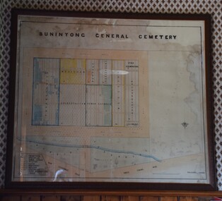 Buninyong Visitor Information Centre
Plan - Cemetery Plan, Buninyong General Cemetery
Plan of the complete layout of the Buninyong General Cemetery drawn by Robert [surname unclear] on 6 April 1871.Framed and glazed original large hand drawn plan of the Buninyong General Cemetery, showing the locations of denominational sections and plots. Buninyong General Cemeterycemeteries, historic sites, buninyong -
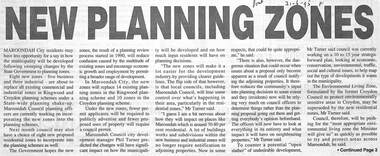 Ringwood and District Historical Society
Newspaper, Scrapbook Clipping, Library Collection, Ringwood, Victoria
Newspaper Clipping from "The Post", 21/6/1995. P1. New Planning ZonesMaroondah City residents may have less opportunity for a say in how the municipality will be developed following sweeping changes by the State Government to planning zones -
Whitehorse Historical Society Inc.
Pamphlet, Blackburn South Recreation Trail, 1989
Pamphlet outlining the history of the linear park along the alignment of the discontinued Healesville freeway.Pamphlet outlining the history of the linear park along the alignment of the discontinued Healesville freeway. It includes plans for the immediate future, the development of Fulton Reserve and lists the Committee of Management. A plan of the area is on the verso.Pamphlet outlining the history of the linear park along the alignment of the discontinued Healesville freeway.wurundjeri walk, fulton reserve, blackburn south recreation trail, city of nunawading -
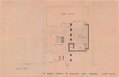 City of Moorabbin Historical Society (Operating the Box Cottage Museum)
Plan - Extension Plans for St.Anne's Church of England, Moylan Street, East Ormond
St Anne's Church of England in Moylan Street, East Ormond was closed in 1995. These plans were drawn up to add an extension to the existing church - but it was never built.Example of the progress of the Municipality of MoorabbinArchitectural Drawings for St Annes Church of England East Ormond - proposed plans for extension 2 pagesst anne's church of england, moylan street, east ormond, religion, building plans -
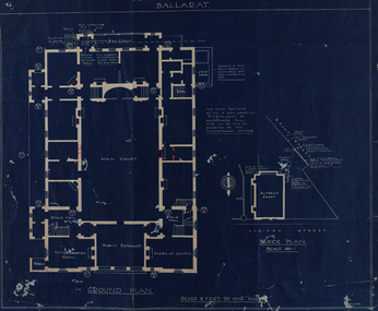 Federation University Historical Collection
Plan - Blueline, Former Ballarat Supreme Court (later Courthouse Theatre)
Blueline plan of the former Ballarat Supreme Court.ballarat school of mines, plan, former ballarat court house, courthouse theatre, wmd, former ballarat supreme court, architectural plan -
Whitehorse Historical Society Inc.
Map, Burwood Road, Box Hill City, 15/02/1952 12:00:00 AM
Plan of subdivision of ten blocks in Burwood Road, Burwood.Plan of subdivision of ten blocks in Burwood Road, Burwood between Milford Avenue and Station Street. Marked as Survey Plan No 5441.Plan of subdivision of ten blocks in Burwood Road, Burwood. land subdivision, burwood road, burwood, milford avenue, burwood, central court, burwood -
Whitehorse Historical Society Inc.
Map, Burwood Road, Box Hill City, 15/02/1952 12:00:00 AM
Plan of subdivision of 19 blocks in Burwood Road, Burwood.Plan of subdivision of 19 blocks in Burwood Road, Burwood between Greenwood Street and Middleborough Road. Marked as Survey Plan No 5442.Plan of subdivision of 19 blocks in Burwood Road, Burwood. land subdivision, burwood road, burwood, greenwood street, burwood, middleborough road, burwood -
 Bendigo Historical Society Inc.
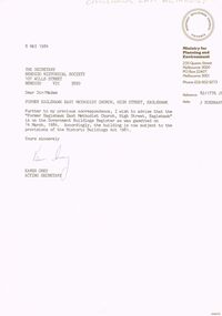
Document - LETTER: INCLUSION OF EAGLEHAWK EAST METHODIST CHURCH ON GOVERNMENT BUILDINGS REGISTER, 08/05/1984
Letter from Ministry for Planning and Environment to Sec., BHS re inclusion of (Former) Eaglehawk East Methodist church on Government Buildings Register. Dated May 8th, 1984. Therefore subject to the provisions of the Historic Buildings Act 1981.Karen Grey from Ministry for Planning and Enviroment, 235 Queen Street Melbourne.church, history, eaglehawk east methodist church, historic building act. eaglehawk methodist church. -
 Kew Historical Society Inc
Plan - Subdivision Plan, Corsewall Estate, Hawthorn, 1938
The Kew Historical Society collection includes almost 100 subdivision plans pertaining to suburbs of the City of Melbourne. Most of these are of Kew, Kew East or Studley Park, although a smaller number are plans of Camberwell, Deepdene, Balwyn and Hawthorn. It is believed that the majority of the plans were gifted to the Society by persons connected with the real estate firm - J. R. Mathers and McMillan, 136 Cotham Road, Kew. The Plans in the collection are rarely in pristine form, being working plans on which the agent would write notes and record lots sold and the prices of these. The subdivision plans are historically significant examples of the growth of urban Melbourne from the beginning of the 20th Century up until the 1980s. A number of the plans are double-sided and often include a photograph on the reverse. A number of the latter are by noted photographers such as J.E. Barnes.This is a second, more complete version of the Corsewall Estate subdivision that is held by the Society. The Coreswall Estate was a subdivision, bordering on Barkers Road and Auburn Road, which created Corsewall Close. This relatively late subdivision included 29 allotments. The subdivision plan includes the dimensions of each lot as well as the width of the existing and projected roads and turning circles. The Corsewall Close Precinct is now listed on the Victorian Heritage Database (HO147) and is noted for its ‘consistent flat-type development over the entire street, which has been cleverly designed to make multi-unit dwellings appear as single buildings’. In this second version of the plan, the rarity of this late subdivision is emphasised by the auctioneers. The original plan must have contained a photograph, which is unfortunately truncated here.subdivision plans - hawthorn, corsewall estate -
 Vision Australia
Plan - Image, RAAF HQ Royal Victorian Institute for the Blind, 14/3/1942
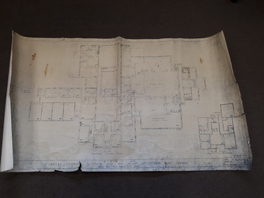
In 1942, the expansion of the war into the Pacific expanded wartime operations in Australia and some of the RVIB buildings were comandeered for house military staff. This plan, drawn up in March 1942 by J.G. and authorised by the Superintending Architect and (W. Dale)Works Director Air Services show the layout of the main building at 557 St Kilda Road as well as that of the babies nursery. Doorways, cupboards and stairwells are annotated in this carbon copy, as well as the layout of Ormond Hall.1 architectural plan of St Kilda Road layoutmyer house, royal victorian institute for the blind, plans, raaf -
Bendigo Historical Society Inc.
Map - BENDIGO WEEROONA GASWORKS MAP/PLAN COLLECTION: FOUNDATION DETAILS, 1942
Plan: Bendigo Weeroona Gasworks. Plan shows foundation detail 140,000 c. ft. gasholder, Bendigo, 1942. Prepared by N.J. Hurll & Co. ( Vic ) Pty. Ltd., King St., Melbourne.plan, bendigo, bendigo weeroona gas works, maps: bendigo weeroona gasworks map/plan collection, gas works, gasholder. -
 Greensborough Historical Society
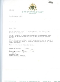
Document - Correspondence and Minutes, Diamond Valley Choral Society, Shire of Diamond Valley Festival of Carols, performed by Diamond Valley Choral Society 1989, 10/12/1989
Planning documents relating to Shire of Diamond Valley Carols, December 1989. This performance is by the Diamond Valley Choral Society.Planning documents, letters and minutes.Some handwritten notes on minutes.diamond valley choral society, christmas music, diamond valley, carols -
 Kew Historical Society Inc
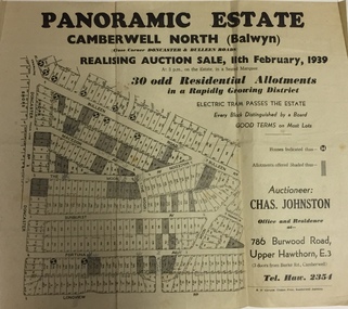
Plan - Subdivision Plan, Panoramic Estate, Camberwell North (Balwyn), 1939, 1939
Subdivision plan advertised as the Panoramic Estate, Balwyn, showing lots for sale in the following streets: Bulleen Road, Macedon Avenue, The Moor, Sunburst Avenue, Doncaster Road, Fortuna Avenue, Longview Road, The Nook, and Touring Avenue.Single page subdivision plan of the Panoramic Estate in Camberwell North (Balwyn); offered for sale in 1939Nilsubdivision plans - balwyn (vic), panoramic estate - camberwell north - balwyn (vic) -
Bendigo Historical Society Inc.
Map - PLAN NEW CHUM LINE OF REEF
Plan showing outcrops of reefs on supposed extension south of the New Chum line of reef from the Eureka extended company's ground. Scale 8 chains to 1 inchplan, bendigo, new chum line of reef -
 Bendigo Historical Society Inc.
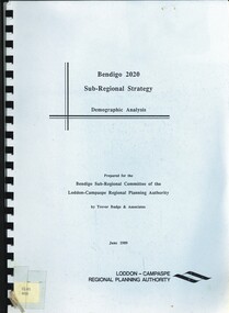
Book - BENDIGO 2020 SUB-REGIONAL STRATEGY, 1989
Bendigo 2020 Sub-Regional Strategy. Demographic Analysis.\ Prepared by Trevor Budge & Assoc for Bendigo Sub-Regional Committee of the Loddon-Campaspe Regional Planning Authority June 1989, 55 pagesTrevor Budge & Assoc for Bendigo Sub-Regional Committee of the Loddon-Campaspe Regional Planning Authoritybendigo, council, future direction & strategies. -
 Greensborough Historical Society
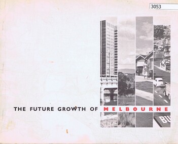
Book, The Future growth of Melbourne, 1967_06
A report to the Minister for Local Government on Melbourne's future growth and its planning administration, June 1967.46 p., text and col. plansmelbourne (victoria), mmbw -
Port Melbourne Historical & Preservation Society
Document - Letter re Planning Scheme amendment 476, Pat Grainger, c.1991
Four pages of nine written by Pat GRAINGER to the Minister for Planning, Jim KENNAN, regarding her objections to Planning Scheme Amendment 476, which was a part of the Bayside project . Typed foolscap of letter re Planning Scheme Amendment No. 476jim kennan, pat grainger, bayside project -
 Kew Historical Society Inc
Plan - Subdivision Plan, Winton Estate, East Kew : Sale of 10 Building Blocks, 1920
The Kew Historical Society's map collection includes a substantial number of real estate subdivision plans, mainly of Kew but also of surrounding suburbs in Melbourne. Most of the subdivision plans date from the 1920s and 1930s when the districts old homes and local farmland were being split up to accommodate residential growth in the postwar period. These early plans were assembled by a local firm, Jas R Mather & McMillan, which had an office in Cotham Road. Many of the plans, and sometimes photos, were annotated by the agents.Subdivision plans are historically important documents used as evidence for the growth of suburbs in Australia. They frequently provide information about when the land was sold as well as evidence relating to surveyors and real estate and financial agents. The numerous subdivision plans in the Kew Historical Society's collection represent working documents, ranging from the initial sketches made in planning a subdivision to printed plans on which auctioneers or agents listed the prices for which individual lots were sold. In a number of cases, the reverse of a subdivision plan in the collection includes a photograph of a house that was also for sale by the agent. These photographs provide significant heritage information relating house design and decoration, fencing and household gardens.The photograph may also be aesthetically significant depending on the importance of the photographic atelier.Subdivision plan for the so-called Winton Estate in East Kew. The Estate comprised 10 lots facing Simpson Street and Campbell Street. The estate was auctioned by Jas. R. Mathers, Son and McMillan. campbell street, simpson street, hunter street, normanby road - kew, subdivision plans - east kew, subdivision plans - kew -
Port Melbourne Historical & Preservation Society
Plan - Water cart used in road construction, Borough of Sandridge, 21 Nov 1870
From a group of maps and plans not required by the Port Melbourne Council Engineering Department in May 1994 and offered at that time to the Port Melbourne Historical Society.Plan of water cart used in road construction including 4 diagrams and scales: signed by Borough Surveyor, Nov 21 1870.built environment - civic, engineering, engineering department - borough of sandridge