Showing 2474 items matching " township"
-
 Ringwood and District Historical Society
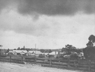
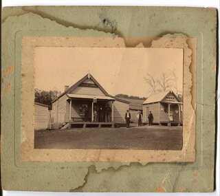
Photograph, Maroondah Highway Central, Ringwood. View of buildings on Maroondah Highway Ringwood, taken overlooking railway yard from Station St. and Greenwood Ave., 1914
Black and white photograph (2 copies)Typed below one photograph: "View of buildings on Maroondah Highway taken overlooking railway yard from Station St. and Greenwood Ave. 1914". Written on rear of backing sheet: "View of township taken from near the Methodist Church showing railway yards, Ringwood Hall and Methodist Church Hall. Methodist Church closed 1915. Photo taken from new one (Cnr. Greenwood Ave.)". -
![Jebb's Pool, on the Erskine River, Near Lorne / [by] Nicholas Caire, circa 1876](/media/collectors/550653872162f11fb04854aa/items/57831524d0cdd1176c4c6452/item-media/5783159dd0cdd1176c4d1cd3/item-fit-380x285.jpg) Kew Historical Society Inc
Kew Historical Society IncPhotograph, Anglo-Australasian Photographic Company, Jebb's Pool, on the Erskine River, Near Lorne, c. 1876
Nicholas Caire was born on Guernsey in the Channel Islands in 1837. He arrived in Adelaide with his parents in about 1860. In 1867, following photographic journeys in Gippsland, he opened a studio in Adelaide. From 1870 to 1876 he lived and worked in Talbot in Central Victoria. In 1876 he purchased T. F. Chuck's studios in the Royal Arcade Melbourne. In 1885, following the introduction of dry plate photography, he began a series of landscape series, which were commercially successful. As a photographer, he travelled extensively through Victoria, photographing places few of his contemporaries had previously seen. He died in 1918. Reference: Jack Cato, 'Caire, Nicholas John (1837–1918)', Australian Dictionary of Biography.An original, rare photograph from the series 'Views of Victoria: General Series' by the photographer, Nicholas Caire (1837-1918). The 60 photographs that comprise the series were issued c. 1876 and reinforced a neo-Romantic view of the Australian landscape to which a growing nationalist movement would respond. Nicholas Caire was active as a photographer in Australia from 1858 until his death in 1918. His vision of the Australian bush and pioneer life had a counterpart in the works of Henry Lawson and other nationalist poets, authors and painters.'Jebb’s Pool, on the Erskine River, near Lorne’ : Views of Victoria (General Series) No.51 : Albumen silver photograph | Photo on card with Title and Description on reverse | Mounted 24 x 30 cm; Photo 12 x 17 cm.On Reverse: ‘Jebb’s Pool is situated about four miles from the township of Lorne, and is so called in consequence of a gentleman named Jebb, whilst crossing the cataract, having fallen in and was swept down by the current into a whirlpool which is continually in motion, owing to the particular formation of the river and the powerful current of water. The depth of water in the pool must be considerable, as but for the timely assistance rendered his life would have been sacrificed.’nicholas caire (1837-1918), lorne (vic), erskine river (vic), landscape photography - victoria -
 Orbost & District Historical Society
black and white photograph, late 19th century / early 20th century
The first settler to occupy the Marlo township area was James Stirling around the year 1875. He built a bark hut on the bluff that had two rooms, bark walls, earthen floors and a shingle roof. By 1884, this structure had expanded to a 9 roomed accommodation house and in 1886 became the Marlo Hotel when a liquor license was granted. The Governor-in-Council declared Marlo to be a township on 18 February 1889. During May 1889, the government surveyor, E.L. Bruce set out 19 sections of the new township, with the first sales of subdivided land occurring the following May. At this time, Stirling's Marlo Hotel was the unofficial hub for the community. It was a general store, accommodation house and the unofficial post office, with settlers taking turns in bringing the mail from Orbost or Cunningham. This continued until Aug 1942, and in 1969 was located in a house adjacent to the Marlo Hotel, before being transferred to the Marlo General Store in this year. The official Post Office List states the Marlo Post Office opened around 1902. in 1925, the "Marlo House" (a nine room accommodation guest house) was granted a liquor licence. The "Marlo House" became "The Marlo Hotel". The Marlo Hotel was popular with many Orbost and district settlers, who travelled to Marlo by horseback or buggy. In the early 20th century the hotel advertised itself as " Under Vice-Regal Patronage. Situated on High Cliff, fronting Ocean, Lakes and Snowy River. Those in search of Health, Rest and Sport should visit Marlo. Boating, Fishing, Shooting, Bathing, Golf. Comfort and Convenience at Marlo Hotel, near Orbost, East Gippsland. Nixon's Cars would meet the train at at Orbost. Fare---6s single, 12s return. Telephone No. 1, Marlo. S, P, STEWART, Proprietor." The Marlo Hotel, perched on the hill overlooking the estuaries and the entrance is a significant building in Marlo. Established in 1886, it has been operating for over 120 yearsAn original black / white photograph and a black / white copy of a party being held under trees on the lawn of the Marlo Hotel. It is a postcard with advertising of Marlo on the back.on back - "Where to spend your holiday - Marlo" on front - "Vice Regal Party at Hotel, Marlo"marlo-hotel -
 Orbost & District Historical Society
black and white photograph, 1936
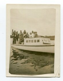
This is a photograph of a fishing party at Marlo, East Gippsland, in 1936. On the back is a description written by Ruby Richardson. Ruby Richarson was born 1902 in Orbost. Her father was Albert Eli and mother Lettice Tomlinson. Ruby had sisters, Mary Agnes Jessie born 1897 and Grace Jane born 1905. Albert Eli Richardson, died in 1851 aged 90i Orbost, His father was given as George Samuel Richardson and mother Jane Farndon, (research - Lois Crisp) The first settler to occupy the Marlo township area was James Stirling around the year 1875. He built a bark hut on the bluff that had two rooms, bark walls, earthen floors and a shingle roof. By 1884, this structure had expanded to a 9 roomed accommodation house and in 1886 became the Marlo Hotel when a liquor license was granted The Governor-in-Council declared Marlo to be a township on 18 February 1889. During May 1889, the government surveyor, E.L. Bruce set out 19 sections of the new township, with the first sales of subdivided land occurring the following May. At this time, Stirling's Marlo Hotel was the unofficial hub for the community. It was a general store, accommodation house and the unofficial post office, with settlers taking turns in bringing the mail from Orbost or Cunningham. This continued until Aug 1942, and in 1969 was located in a house adjacent to the Marlo Hotel, before being transferred to the Marlo General Store in this year. The official Post Office List states the Marlo Post Office opened around 1902.[ In 1925, the "Marlo House" (a nine room accommodation guest house) was granted a liquor licence. The "Marlo House" became "The Marlo Hotel". The Marlo Hotel was popular with many Orbost and district settlers, who travelled to Marlo by horseback or buggy. Marlo has always been a popular destination for fishermen. A small black / white photograph of a group of men and women on a small boat.on back - "Fishing party..................Ruby Richardson"marlo-fishing recreation-fishing -
 Bendigo Art Gallery
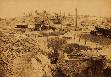
Photograph - Work on paper, Nicholas CAIRE, View of North Old Chum Claim, showing surface Excavations, 1875
Inscribed on original mountcard, l.l., gold letterpress, "N.J. CAIRE". Not dated.albumen, photograph, bendigo, sandhurst, regional victoria, goldfields, township, city -
 Orbost & District Historical Society
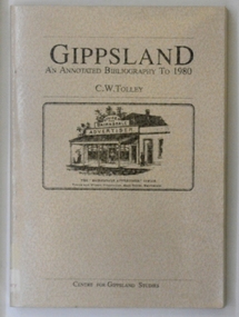
book, Gippsland Institute of Advanced Education, Gippsland An Annotated Bibliography to 1980, 1987
The Gippsland Institute of Advanced Education was established in September 1968. On its establishment, the institute assumed responsibility for the diploma courses previously offered by the Yallourn Technical College which had commenced diploma teaching in 1929. Initially, all the Institute's teaching was conducted in the diploma building of the Yallourn Technical College. In 1972 the Institute transferred part of its operations to the first of its permanent buildings on a large campus in rural surrounds near the township of Churchill south of Morwell. The Gippsland Institute of Advanced Education was opened on 20 November 1976. This book is a useful reference book for research into the history and establishment of Gippsland.A 232 pp plastic-covered soft covered book, The front cover is beige with the title, " Gippsland An Annotated Bibliography to 1980 C.W. Tolley" in black print at the top. In the middle is a black/white print detail from a lithograph of Bairnsdale Advertiser office in 1888. At the foot in black print is "Centre For Gippsland Studies". The book contains a list of books relating to the local social history , agriculture, indigenous, planning and resources . book-bibliography-gippsland gippsland-institute-of-advanced-education -
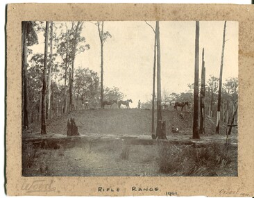 Orbost & District Historical Society
black and white photograph, Wood, 1901
This photograph appears to have been taken during the construction of the rifle range just north of the Orbost township. "The photo shows the range stop butt being formed by the scoops being pulled by the horses. It appears that the rear of the mound there is a wall of logs lining it, most likely to help with being eroded or washed away. They haven’t yet formed the mantlet and target machines." ( Info, from Victorian Rifle Association) The Orbost Rifle Club existed in the early 20th century. (There are records from 1900). It folded in the late 1970's.Target shooting is one of the oldest organised sports in Australia. Records date back to the British Marines at Sydney Cove in 1788. The Victorian Rifle Association (VRA) was formed in 1860. After Federation in 1901, rifle clubs came under army control, but in 1921 they were reconstituted as a civilian organisation, which they have remained ever since. After World War I a system of national training was embodied in the Defence Act and the rifle clubs reverted to their purely sporting role. A black / white photograph of four men and four horses standing an a soil bank with another man, a lady and a small girl at the base of the hill. It is in a clearing in forest. It appears to have a row of targets set at the edge of the bank. The photograph is mounted on a very mouldy cream coloured buff card.on front - "Wood" ; "Rifle Range - 1901" ; "Orbost 1901"sport-shooting orbost-rifle-range -
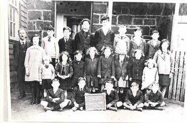
 Kiewa Valley Historical Society
Photo - Tawonga Primary School pupils 1920, 1920
Tawonga Primary School Children 1920. Tawonga is in the Kiewa Valley where farmers lived with their families. The school was opened on 27th July 1880 situated on 8 acres near the current township of Tawonga. This school was erased by fire in 1900 and all records were destroyed. The school then moved to the old Tawonga Hall. In 1910 the school was shifted to its present site on 3 acres of land donated by Frank Cooper. The school building and attendance continued to grow especially during the construction of the Kiewa Hydro Electric Scheme. Early residents of the area. Ellie Seymour front row first on left. Walter J E Ryder in front of the desk at right. Vera Ryder behind him on the right. The boys also wore white collarsCopy of black and white photograph of pupils (children) at Tawonga Primary School 1920tawonga primary school, state school, kiewa valley -
 Eltham District Historical Society Inc
Newsletter, Newsletter, No. 247 August 2019
Contents: • Russell Yeoman – our Secretary for 50 Years by Jim Connor • Our Next Meeting – Wednesday 14th August 2019 • September Excursion – Culla Hill Walk • The Value of History Statement • Eltham Reminiscences by R.D. Taylor • Australia post: Gold brought life to the township • Postmaster-General’s Department of Australia • Eltham Cemetery Stories by Richard Pinn o Patrick Carrucan o Nina Mikhailovna Christesen • Our Recent Heritage Excursions by Jim Connor • Contacts for the Eltham District Historical Society The Shire of Eltham Historical Society was formed in October 1967. The first newsletter of the Society was issued May 1978 and has been published continuously ever since on a bi-monthly basis. With the cessation of the Shire of Eltham in late 1994, the Society's name was revised to Eltham District Historical Society and this name first appeared with issue No. 103, July 1995. The collection of the Society's newsletters provides a valuable resource on the history of the Society's activities, office bearers and committee members, guest speakers and subjects of historical interest pertinent to the former Shire of Eltham and the Eltham District.A4 newsletter distributed to membersnewsletter, eltham district historical society -
 Eltham District Historical Society Inc
Folder, Schools no 209 Eltham and no 371 Little Eltham, 1970
Information collated about the early history of Eltham Primary School (n 209) from the Education Department Victoria, 1970 (some duplicated) and School no. 371 "Little Eltham" operated by the Church of England. Includes hand written extracts from correspondence registers of the denominational school board from Public Records Office Victoria (marked pages 77-83 from Chappel file). Copy of handwritten letter from the PROV file dated April 20 1872 advocating the need and preservation of the two schools in the township. 12 pages. PhotocopiesHG Booklet 40harry gilham collection, church of england school, eltham primary school, eltham state school -
 Eltham District Historical Society Inc
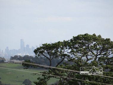
Photograph, Liz Pidgeon, View of Melbourne from the Moor-rul viewing platform at the War Memorial Park at Kangaroo Ground, 10 August 2016
View of Melbourne from the Moor-rul viewing platform at the War Memorial Park at Kangaroo Ground. As part of a program to acknowledge the Anzac Centenary Nillumbik Shire Council partnered with Yarra Plenty Regional Library to provide a bus tour with commentary of local sites of significance. These included Eltham township, the Shire of Eltham War Memorial at Kangaroo Ground, Christmas Hills war memorial, Hurstbridge memorial recreation park and finshed at Eltham Library to view the Writing the War exhibtion at Eltham Library Community Gallery. Born Digitalwar memorials, shire of nillumbik, kangaroo ground, moor-rul viewing platform, melbourne, skyline, view -
 Eltham District Historical Society Inc
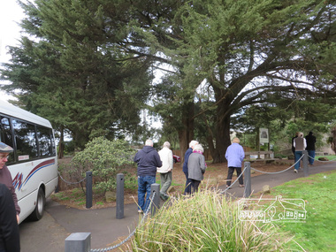
Photograph, Shire of Nillumbik World War One Memorials tour, 10 August 2016, 10 August 2016
As part of a program to acknowledge the Anzac Centenary Nillumbik Shire Council partnered with Yarra Plenty Regional Library to provide a bus tour with commentary of local sites of significance. These included Eltham township, the Shire of Eltham War Memorial at Kangaroo Ground, Christmas Hills, Hurstbridge memorial recreation park and finished at Eltham Library to view the Writing the War exhibtion at Eltham Library Community Gallery. Shire of Eltham War Memorial at Kangaroo Ground War Memorial Park. Path way with trees leading up to the base of the tower. Born Digitalworld war 1, war memorials, shire of nillumbik, tour, kangaroo ground, kangaroo ground memorial -
 Eltham District Historical Society Inc
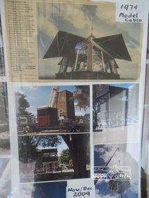
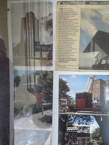
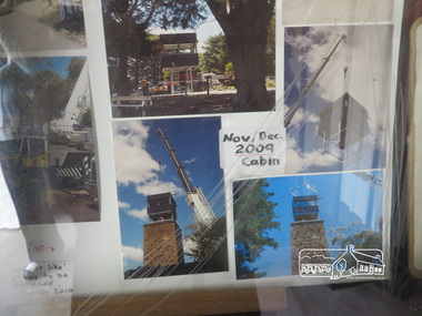
Photograph, Liz Pidgeon, Kangaroo Ground War Memorial Park: Photo display, 10 August 2016
Glass cabinet at the base of the stairs at the tower showing colour photographs depicitng the installation of the CFA tower in November/ December 2009. As part of a program to acknowledge the Anzac Centenary Nillumbik Shire Council partnered with Yarra Plenty Regional Library to provide a bus tour with commentary of local sites of significance. These included Eltham township, the Shire of Eltham War Memorial at Kangaroo Ground, Christmas Hills, Hurstbridge memorial recreation park and finished at Eltham Library to view the Writing the War exhibtion at Eltham Library Community Gallery.Born Digitalworld war 1, war memorials, shire of nillumbik, kangaroo ground, heritage display, shire of eltham war memorial, cfa -
 Eltham District Historical Society Inc
Photograph, Liz Pidgeon, Kangaroo Ground War Memorial Park: Photo display, 10 August 2016
Glass cabinet at the base of the stairs at the tower showing colour photographs depicitng the installation of the CFA tower in November/ December 2009. As part of a program to acknowledge the Anzac Centenary Nillumbik Shire Council partnered with Yarra Plenty Regional Library to provide a bus tour with commentary of local sites of significance. These included Eltham township, the Shire of Eltham War Memorial at Kangaroo Ground, Christmas Hills, Hurstbridge memorial recreation park and finished at Eltham Library to view the Writing the War exhibtion at Eltham Library Community Gallery. Born Digitalworld war 1, war memorials, shire of nillumbik, kangaroo ground, heritage display, shire of eltham war memorial, cfa -
 Orbost & District Historical Society
black and white photograph, early 20th century
The hotel at Bonang was also known as Clancy's Hotel, Bonang, after its licensee, William Clancy. It operated from the late 1890s until early 20th century. William Clancy was aslo the postmaster at Bonang. A post office operated at Bonang from at least 1859. At the time Bonang was "a small, scattered collection of buildings marking the intersection of the Bonang Highway and the McKillops Bridge Road" ( from Regional Heritage Assessment 1996). As the mining activity declined the township became even smaller as many of the population moved to Orbost,, a larger settlement. This is a pictorial record of Bonang, a small settlement approximately 50 km north of Orbost. The buildings in the photograph no longer exist.A black / white photograph mounted on grey card. there are stains from water damage on the mount. It is a photograph of two single-storeyed timber buildings fronting a wide dirt road. On the right is the Bonang Hotel with four men in suits standing on a verandah. The building on the right is the Bonang Post Office and there are three men outside it. the photograph has been posed. on back - 'Grandma Clancy owned the hotel & Uncle Will had a gold mine which he worked"bonang bonang-post-office bonang-hotel clancy-william clancy's-hotel-bonang -
 Orbost & District Historical Society
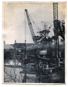
black and white photographs, 1975
These are photographs of the construction of the current cement road bridge across the Snowy River at Orbost. Construction of the bridges commenced in January 1975, with an expectation to open the bridge across the Snowy River as soon as possible. Less than two years later, on 25 November 1976, the bridge across the Snowy River was opened to traffic, allowing the old bridge to be demolished. The remainder of the Orbost Bypass, both the floodplain crossings and the eastern section around the township itself, was declared ‘Princes Freeway’ and opened to traffic in December 1977. (ref http://mrv.ozroads.com.au)The opening of this Snowy River Bridge was an important development in the accessibility to the township of Orbost. These photographs record its construction.Two black / white photographs showing the construction of a road bridge across a river. 3257.1 shows piles being dropped beside the bridge, 3257.2 is of the early stages of construction of this bridge.snowy-river-bridge-orbost road-construction-orbost bridge-orbost -
 Marysville & District Historical Society
Booklet (Item) - Leisure guide, Michael Chesire & Associates Pty. Ltd, MARYSVILLE & DISTRICT LEISURE GUIDE-AUTUMN/WINTER, 1986, 1986
A free leisure guide to Marysville and the surrounding district published for Autumn and Winter, 1986. This was produced by Michael Cheshire as a free publication to promote tourism in Marysville and the surrounding district. It includes maps of the Big River Valley, Cumberland Valley, Lady Talbot Forest Drive, the Marysville area, and the township of Marysville. It was released in the autumn of 1986 and was sponsored by the Marysville Tourist & Progress Association. The Association was formed in November 1907 to promote tourism within the area. This included the physical creation of signage, parklands, roads, and walks to various attractions. A free leisure guide to Marysville and the surrounding district published for Autumn and Winter, 1986.marysville, victoria, australia, leisure guide, michael cheshire & associates pty ltd, marysville golf club, blackwood lodges, sir colin mackenzie fauna park, lake eildon, fraser national park, yarra valley wineries, marysville coach tours, kooringa, marylands guest house, lady talbot forest drive, wishing well, taggerty river recreation area, athols abbey, phantom falls, keppel falls, the beeches walking track, marylyn guest house, kufstein inn motel, the cumberland, marysville tourist & progress association, marysville newsagency & general store, crossways restaurant & motel, beauty spot walk, tree fern gully walk, michaeldene track, keppel track, woods lookout track, marysville hotel motel, lake mountain ski hire, marysville recreation and fun park, mytanta horseback safaris, upper big river valley, the big culvert, marysville mountain view horse hire, maryton park, amber view holiday lodges, cathedral restaurant, the top shop, tower motel, menzes garage, beauty spot nursery, marysville ski hire, lake mountain ski school, faraway forest, scenic motel, buxton trout farm, marysville hardware, timbertop steakhouse, marysville trout farm, healesville sanctuary, buxton hotel motel, nanda binya lodge, buxton antique and furniture mart, the black spur inn hotel, alexandra, lake mountain, geoffrey pope & associates -
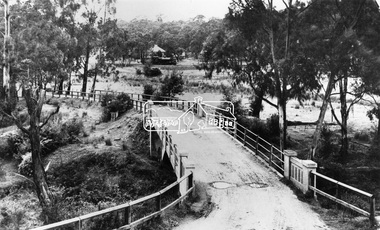 Eltham District Historical Society Inc
Negative - Photograph, View across bridge at Hurstbridge, Vic, c.1922
View across the new Monash bridge across the Diamond Creek at Hurstbridge looking towards the township, note steam train in centre background of image. Dated between the opening of bridge Nov. 1917 and provision of electric rail service Aug. 1926 - c.1922. Part of a slide show presentation "Bridges & Waterways of the Shire" by Russell Yeoman to the 13 September 1989 Society meeting. The presentation included slides of historic photos from the Shire of Eltham Pioneers collections as well as several recent views.This photo forms part of a collection of photographs gathered by the Shire of Eltham for their centenary project book ,"Pioneers and Painters: 100 years of the Shire of Eltham" by Alan Marshall (1971). The collection of over 500 images is held in partnership between Eltham District Historical Society and Yarra Plenty Regional Library (Eltham Library) and is now formally known as 'The Shire of Eltham Pioneers Photograph Collection.' It is significant in being the first community sourced collection representing the places and people of the Shire's first one hundred years.Digital image 4 x 5 inch B&W Negshire of eltham pioneers photograph collection, hurstbridge, bridge, steam train, diamond creek (creek), railway line, monash bridge -
 Eltham District Historical Society Inc
Document - Map, Victoria. Department of Crown Lands and Survey, Town of Eltham, Parish of Nillumbik, County of Evelyn, 2 October 1929
Township of Eltham, Parish of Nillumbik, County of Evelyn / lithographed at the Department of Lands & Survey Melbourne 5th June 1888, amended 2 October 1929 This amendment from the 1888 original shows the reserve for the the State School marked as permanent with dimensions added to Main Road and block frontages along Main Road between Mount Pleasant Road and Dalton Street and Metery Road Possibly photocopied from a copy held at PROV by Harry Gilham whilst resaerching Eltham Primary School history in 1995.a. armstrong, a. lavard, arthur c. allan, arthur c. allen, b. bowatere, baxter street, benjamin oliver wallis, bolton steet, c. souter, c.s. hain, cemetery reserve, charles brown, charles newman, charles symons wingrove, christopher caldwell, church of england, d. anderson, dalton street, david ballard, e. james, e.m. peck, edward dumaresq, eltham town, ely street, f.e. falkiner, f.m. peck, falkiner street, flint street, g. buckingham, g. drabble, george stebbing, godalmin street, h. peck, h.c.whess, h.h. farquharson, h.j. bews, henry stooke, j. goer, j. mcdonald, j. mclaren, j. roberts, j.b. knagers, james irish, jane bailey (nee matthews), john l. smith, john mason, john scott, john smith, joseph stevenson, joseph verse, k. wingrove, k.e. dunstan, kerby street, kirby street, location tbd, m. coman, map, michael o'shea, o.b. mccutcheon, p. & g. tumbull, p.k. mccaughan, p.p. cotter, porter street, pound reserve, robert hepburn, roman catholic church, s. evans, samuel dagley, samuel phillips, samuel ramsden, t. upton, t. watkins, t.a. stark, t.c.b. batt, t.p. cross, thomas grant, thornton street, w. adam, w. blain, w. long, w. watkins, w.f. ford, w.h. hull, w.r. belcher, w.t. schultz, william thomas, eltham primary school, eltham state school, eltham state school no. 209, quarry reserve -
 Eltham District Historical Society Inc
Photograph, Liz Pidgeon, Kangaroo Ground War Memorial Park: Photo display, 10 August 2016
Glass cabinet at the base of the stairs at the tower showing colour photographs depicting the installation of the CFA tower in November/ December 2009. As part of a program to acknowledge the Anzac Centenary Nillumbik Shire Council partnered with Yarra Plenty Regional Library to provide a bus tour with commentary of local sites of significance. These included Eltham township, the Shire of Eltham War Memorial at Kangaroo Ground, Christmas Hills, Hurstbridge memorial recreation park and finished at Eltham Library to view the Writing the War exhibtion at Eltham Library Community Gallery. Born Digitalwar memorials, shire of nillumbik, heritage display, kangaroo ground, shire of eltham war memorial, photos -
 Hume City Civic Collection
Photograph, Bulla State School, 1930
The class photograph was taken at the Bulla State School No. 46 in 1930. Two children have been identified. They are John Daniel, seated in the front row, second from the left. Vincent Daniel is standing, first on the left in the back row. The Daniel family were store holders in the Bulla township. Over the years a teacher's residence and another larger weatherboard classroom were added to the original bluestone building. The school functioned for over 100 years from the late 1870s until 2006 when it was closed and is now a private house.The Bulla State School was one of the oldest schools in the district and served the children from surrounding areas. A black and white school photograph which has been photographed from another image. The twenty two children of twelve boys and ten girls are in three rows and standing in front of a bluestone building with their teacher.bulla state school no46, daniel john, daniel vincent, schools -
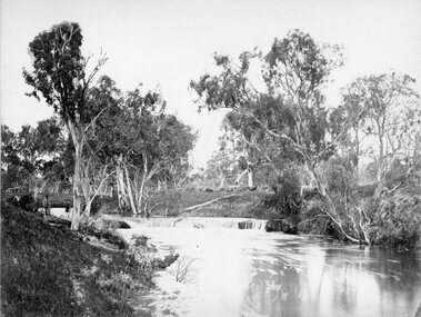 Stawell Historical Society Inc
Photograph, Wimmera Falls in Glenorchy 1866
Wimmera Falls Glenorchy. Part of a collection of Photographs by Mr. O.G. Armstrong as commissioned by the Shire of Stawell for the Inter-colonial and Paris Exhibition in Melbourne in 1866. The fact that there was ever a natural waterfall in the Wimmer River would probably be a surprise to anyone who has known the river at all. There are many man-made weirs across it in several places today, one of them at Glenorchy is thought to hide the original falls. A Stawell Paper dated 21st August 1888, refers to them being a mile below the Township. View of river amongst gum trees with shallow falls at centre of photograph.stawell -
 Eltham District Historical Society Inc
Folder, Thomas Armstrong
Armstrong, Thomas, J.P. Yarra Flats, was born in Roxburghshire, Scotland, in 1818, and in 1838, being then twenty years of age, emigrated to Australia, and engaged in taking contracts. In 1841, in conjunction with Mr. Wm. Bell he took out a squatting license and settled in what is now known as the township of Eltham. Mr Armstrong purchased land on Kangaroo Ground, where he lived, until 1854, and then bought from Mr. John Dickson, a station on Yarra Flats, containing about 100,000, which at the expiration of two years was sold by public auction. Messrs Armstrong and Bell then bought 14,000 acres where Mr Armstrong, now resides. He has been a member of the local council for twenty-eight years, and holds Her Majesty’s commission of the peace. His wife, Miss Diana Bell (daughter of his partner, Mr. Wm. Bell), whom he married in 1841, died fifteen years ago. from "Victoria and its Metropolis: Past and Present" written in 1888 by Alexander Sutherland. Chapter 19, "The Upper Yarra District" pages [402] - 415. Includes descriptions of some townships and short biographies of local residents. Page 405 Folder of information on Thomas Armstrong, JP, Kangaroo Groundthomas armstrong -
 Linton and District Historical Society Inc
Photograph, 'Glenfine' Shearing Shed, 1890
In July 1840, Glenfine, consisting of 31,440 acres, was acquired by Thomas Downie. In March 1842 the 'Right of Run' was taken up by Thomas Chirnside who with an imported stallion 'Delapre' ran a horse stud. He apparently lived here for ten years and employed a gardener with a wife and five children from Hobart, Tasmania. Only some blocks of stone and a few trees remain of their homestead. In 1853 the property was transferred to Dr. John Chirnside, an elder brother of Thomas Chirnside. In 1857, William Rowe of Naringal purchased Glenfiine where he and his family lived until 1904 when it was bought by Richard Howell's estate. It was then 39,000 acres. The present house was built by the Rowes in 1872 of bluestone quarried on the property with a cement render overall. The architect was H.R. Casselli. Gold was found on the property and by 1898 the township of Hollybush was first reported, situated at either side of the front entrance, on the Cressy Road. The land for the township was given by William Rowe. In 1911 R.C. Howell, son of Richard Howell, became the owner, followed by his son in 1960. By 1990 Hollybush had a population of 426 persons. All of the early history of Glenfine, documents etc., were destroyed when Naringal homestead was burnt down in 1944. Glenfine was classified by the National Trust in 1974 and is on the Heritage Commission Register. Mounted black and white image of a large group of men and boys in front of a weatherboard shearing shed. The men are each holding a pair of hand shears. One young man is kneeling on top of a wool bale. A small blue biro 'x' identifies W. Todd. Glenfine was a pastoral station, and the original homestead still stands.shearing sheds, shearers, rural activity, william todd, glenfine pastoral station, thomas chirnside, thomas downie, richard howell, william thomas rowe -
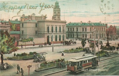 Ballarat Tramway Museum
Postcard - copy, "Sturt Street looking E., Ballarat" and "Happy New Years", c2000
Yields information about the appearance of Sturt St following the introduction of electric trams in 1905 and has a strong association with the work of Sovereign Hill and Rose Stereograph Co.Postcard reproduction - coloured - of an ESCo tram near the intersection of Armstrong St. and Sturt St. travelling west along the south side of Sturt Street with the Post Office and bank buildings on the corner of Sturt and Lydiard Sts in the view. Photo appears to be taken soon after opening of the electric trams, ESCo tram has destination board on the front dash of the tram. Card reproduced for Sovereign Hill Gold Mining Township by Rose Stereograph Co. of Glen Waverley c2000. Divided back type with caption, production and the Rose Co. symbol on the rear.trams, tramways, sturt st, ballarat, esco, rose postcards -
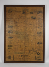 Bacchus Marsh & District Historical Society
Map, The Unique Advertising Combine, The Unique Combine's New Map of the Shire of Bacchus Marsh, 1890
This map was one of a number of similar maps produced for advertising purposes by a company called, 'The Unique Advertising Combine'. The company was located in Melbourne on Queens Walk. A brief item in the Bacchus Marsh Express newspaper on 29 March 1890 , page 2, indicated that subscribers to the Bacchus Marsh Express could obtain a copy of this map in the next issue of that newspaper. On the map is the detail that it was compiled by W.H. Bonney from official records supplied by D. A. Little, hire Secretary, (of Bacchus Marsh Shire).This map with its accompanying illustrations of local businesses and shops in Bacchus Marsh is an important documentary and visual snapshot of the town and district of Bacchus Marsh in the later part of the nineteenth century. The illustrations for some of the local businesses are the only known visual record of those particular buildings. The map is a rare surviving example of the material produced by The Unique Advertising Combine. Another similar example for the Shire of Mornington is held by the State Library of Victoria,A map of the Shire of Bacchus Marsh produced in March 1890. The map is mounted on a board and enclosed within a timber frame. The map includes an inset detail section showing the central part of the township of Bacchus Marsh including the main shopping and business streets. Land holdings with the first European land holders names indicated are included on the map. Rivers, creeks, major roads and the railway line are also shown on the map. Around the edges of the map are illustrated advertisements mostly for Bacchus Marsh businesses but which also includes some businesses located in Melbourne. maps bacchus marsh shire, shops bacchus marsh -
![Entrance to Fernshawe / [by] Nicholas Caire, circa 1876](/media/collectors/550653872162f11fb04854aa/items/577b462bd0cdd10948c53643/item-media/577b46c2d0cdd10948c58d0c/item-fit-380x285.jpg) Kew Historical Society Inc
Kew Historical Society IncPhotograph, Anglo-Australasian Photographic Company, Entrance to Fernshawe, c. 1876
Nicholas Caire was born on Guernsey in the Channel Islands in 1837. He arrived in Adelaide with his parents in about 1860. In 1867, following photographic journeys in Gippsland, he opened a studio in Adelaide. From 1870 to 1876 he lived and worked in Talbot in Central Victoria. In 1876 he purchased T. F. Chuck's studios in the Royal Arcade Melbourne. In 1885, following the introduction of dry plate photography, he began a series of landscape series, which were commercially successful. As a photographer, he travelled extensively through Victoria, photographing places few of his contemporaries had previously seen. He died in 1918. Reference: Jack Cato, 'Caire, Nicholas John (1837–1918)', Australian Dictionary of Biography, National Centre of Biography.An original, rare photograph from the series 'Views of Victoria: General Series' by the photographer, Nicholas Caire (1837-1918). The series of 60 photographs that comprise the series was issued c. 1876 and reinforced a neo-Romantic view of the Australian landscape to which a growing nationalist movement would respond. Nicholas Caire was active as a photographer in Australia from 1858 until his death in 1918. His vision of the Australian bush and pioneer life had a counterpart in the works of Henry Lawson and other nationalist poets, authors and painters.Albumen silver photograph mounted on boardPrinted inscription on reverse: A fifty-mile drive from Melbourne, via Lilydale, will bring the traveller to the township of Fernshawe. On nearing the entrance to the town, the scenery becomes most enchanting. In the distance can be seen the summit of Mount Munday. The ridge of trees in the middleground forms part of the foot of the Black Spur. The building in the foreground is the residence of the only Government Official, who represents the various titles of Post-master, State School Teacher, Registrar, &c.landscape photography - australia - 19th century, nicholas caire -
 Orbost & District Historical Society
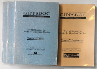
books, Gippsland Institute of Advanced Education, Gippsdoc A Bibliography of Gippsland, 2292.`1; 2292.2; 2292.3 in 1989 and 2292.4 in 1993
The Gippsland Institute of Advanced Education was opened on 20 November 1976. The Council of the Institute included members of the Gippsland community who are prominent in local government, industry, commerce, education and the professions, the Director of the Institute, and representatives of the academic staff, students, and graduates. The institute assumed responsibility for the diploma courses previously offered by the Yallourn Technical College. Initially, all the Institute's teaching was conducted in the diploma building of the Yallourn Technical College. In 1972 the Institute transferred part of its operations to the first of its permanent buildings on a large campus in rural surrounds near the township of Churchill.These books are useful reference tools.Four thick volumes of "Gippsdoc A Bibliography of Gippsland". Volumes 1, 2 and 3 have blue covers and Volume 4, the Supplement, has a beige cover. Volume 3 has 1072 pp and is an index. These books list published books which are about Gippsland.books-a-bibliography-of-gippsland gippsland-institute-of-advance-education -
 Eltham District Historical Society Inc
Photograph, Shire of Nillumbik World War One Memorials tour, 10 August 2016, 10 August 2016
As part of a program to acknowledge the Anzac Centenary Nillumbik Shire Council partnered with Yarra Plenty Regional Library to provide a bus tour with commentary of local sites of significance. These included Eltham township, the Shire of Eltham War Memorial at Kangaroo Ground, Christmas Hills, Hurstbridge memorial recreation park and finshed at Eltham Library to view the Writing the War exhibtion at Eltham Library Community Gallery. EDHS Members Alan and Marilyn Butler in foreground listening to short presentation about the Christmas Hills Mechanics Institute by a local resident and Hall Committee Member Veronica Holland. Born Digitalchristmas hills mechanics institute, tour, visitors, veronica holland -
 Eltham District Historical Society Inc
Photograph, Kangaroo Ground War Memorial Park: Photo display, 10 August 2016
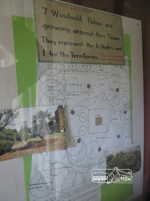
Display in glass cabinet at the base of the stairs at the tower at Kangaroo Ground. 7 windmill palms are growing around the tower. They represent 6 states and 1 for the Territories with map and photo. As part of a program to acknowledge the Anzac Centenary Nillumbik Shire Council partnered with Yarra Plenty Regional Library to provide a bus tour with commentary of local sites of significance. These included Eltham township, the Shire of Eltham War Memorial at Kangaroo Ground, Christmas Hills, Hurstbridge memorial recreation park and finished at Eltham Library to view the Writing the War exhibtion at Eltham Library Community Gallery. Born Digitalworld war 1, war memorials, shire of nillumbik, heritage display, shire of eltham war memorial, kangaroo ground