Showing 10954 items matching "land "
-
 Whitehorse Historical Society Inc.
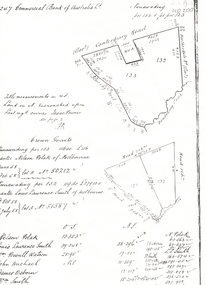
Legal record - Land Title, Crown grant, 1858
Commercial Bank of Australia record of Crown Grants of land to Nelson Polak and Louis Laurence Smith in 1858.Commercial Bank of Australia record of Crown Grants of land to Nelson Polak and Louis Laurence Smith in 1858. The land is between Canterbury Road, Heatherdale Road, 'Scoresby Road' (now Boronia Road) and the Dandenong Creek.Commercial Bank of Australia record of Crown Grants of land to Nelson Polak and Louis Laurence Smith in 1858. polak, nelson, smith, l l dr, canterbury road, vermont, boronia road, dandenong creek, heatherdale road, land sales -
 Whitehorse Historical Society Inc.
Article, Carving up the Eastern Suburbs
Newspaper article about Tommy Bent and Sir Benjamin Benjamin and their land buys in the Eastern SuburbsNewspaper article about Tommy Bent and Sir Benjamin Benjamin and their land buys in the Eastern Suburbs, and the 'Queens Park Tenner' issued as a deposit for a land sale, cnr Station Street and Canterbury Roads (copy shown)Newspaper article about Tommy Bent and Sir Benjamin Benjamin and their land buys in the Eastern Suburbsland subdivision, station street, box hill, canterbury road, bent, thomas, benjamin, benjamin (sir), queens park estate, queens park tenner, freehold investment and banking company of australia ltd -
 Southern Sherbrooke Historical Society Inc.
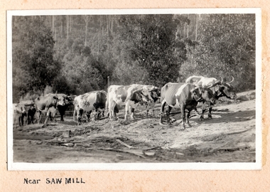
Photograph, Near Saw Mill
Ten or more cattle pulling logs to a sawmill (possibly McLaren's sawmill in Belgrave). The land around the track is cleared and it is heavily treed in the background. There is dead timber lying around and the land looks dry. c.1920. -
Whitehorse Historical Society Inc.
Document, 'Willowbank', 1985
Notes by Jean Uhl on interview, 1985, about 'Willowbank'Notes by Jean Uhl on interview, 1985, about 'Willowbank', used to be called 'Willowbridge' (named 'Willowbridge' by Mrs B. Rawson). Home was built 1880, land originally subdivided by Gerard Letts, German family thought to be original builders. Situated at 3 Moore Road, Vermont. 1978 purchased by R.B. Evans,Notes by Jean Uhl on interview, 1985, about 'Willowbank'willowbank', uhl, jean, letts, gerard, rawson, b. (mrs), evans, r.b. (mr), moore street, vermont, no. 3 -
 Kew Historical Society Inc
Photograph - Flooding of the Yarra Valley at Kew East, 1974
Flooding of the Yarra Valley, including that section of the Yarra bordering Kew and Kew East in the north and west of the municipality, was a regular occurrence. Extreme flood events of the Yarra River are recorded to have occurred in 1891, 1901, 1916, 1923 and 1934. The Municipality of Kew's response to these floods was to enact planning decisions restricting residential development in flood prone areas following the floods of 1916, 1921 and 1934. While floods continued after the development of the Upper Yarra Reservoir (construction 1948-57), the regularity and extent of these inundations diminished. During the nineteenth century, the land abutting the south side of the Yarra in Kew was devoted to dairy farming. In the twentieth century, before and after the construction of the Eastern Freeway, much of this low-lying area was used as golf courses and public parks.Late example of the capacity of the Yarra Valley at Kew to flood, even though drainage works and the Upper Yarra Reservoir had reduced their regularity.Original black and white print photograph of the low-lying land at East Kew under floodwater on 16 May 1974. The vantage point of the photographer is at Willsmere Road. The road itself is underwater.Annotation verso: "Willsmere Rd / Same as No.7 / 16 May 1974 11.15am"floods, yarra river, willsmere road -
 Phillip Island and District Historical Society Inc.
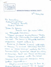
Letter, Eliza Cochlan, information on spelling of her name, 1986
The spelling of Eliza's surname varies between Coghlan and Cochlan in various sources.The letter does not provide proof of either. List of applicants for land at Schnapper Point [Mornington, including Phillip Island], early settlers and their date of arrival. An extract from "Early History of Mornington" showing residents of Schnapper Point in 1858.HistoricalHand written letter from the secretary of the Mornington Peninsula Historical Society re the spelling of Eliza Cochlan's name . Dated 8/5/1986 Also 3 typed pages containing a list of applicants for Phillip Island land grants and extract from The Early history of Mornington.Letter addressed to Mr Harris, secretary PIDHSeliza cochlan, land grant, early phillip island settlers, land ballot -
 Charlton Golden Grains Museum Inc
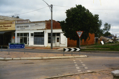
Photograph, West end Charlton High St c. 1987, c.1989
Shops at the west end and on the south side of High St. Eddie Harris Mensland, and three small shops; Charles McKinley's Land Sales Agency, Hillier's Dr Cleaners and Manchester Unity. The three small shops were damaged by fire and demolished in the 1990s. Series of photos taken for use by the Charlton Shire.Colour photo of shops at the west end and on the south side of High St.Eddie Harris Mensland, Mickinley's Land Sales Agency, Hillier's Dr Cleaners and Manchester Unity. Sign on median strip pointing to Rotary Park, Public Conveniences, Electric Barbeque. Also a Give Way sign.eddie harris mensland, charles mckinley, hilliers, charlton, business, industry -
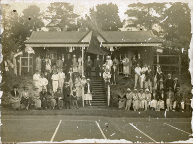 City of Moorabbin Historical Society (Operating the Box Cottage Museum)
Photograph, black & white Cheltenham Tennis Club 1920, and 2 Documents, 1920
Cheltenham Tennis Club was established 1883 when Shire of Moorabbin released land in Cheltenham Park for recreational use. 1924 The Shire of Moorabbin gave permission for the development of extra Courts.Cheltenham Tennis Club 1883 was one of the first Tennis Clubs established in Melbourne.A black and white photograph of men and women seated and standing in and around the Cheltenham Tennis Clubhouse in Cheltenham Park, Cheltenham in 1920. Letter Handwritten 1883 Shire of Moorabbin, South Brighton , release of land in Cheltenham Park for the development of Tennis Courts. Letter Typed 1924 Shire of Moorabbin, permission for extra Courts, signed by the shire secretary, Alexander Chalmers Smith.PHOTO ; written on back : Cheltenham Tennis Club 1920 / Cheltenham Park Letter ; signed John Keys Shire of Moorabbin South Brighton Logo 1871 Letter ; Shire of Moorabbin Logo 1924charman road, cheltenham, 1920, tennis club. charman stephen, gettens mary, spring grove, charman road, balcombe road, nepean road, dairy farmers, market agrdeners, poultry farmers, methodist church, keys john, shire of moorabbin, colsamix, cheltenham park melbourne, sabbath victorian law article 26, cheltenham golf club -
 Bayside Gallery - Bayside City Council Art & Heritage Collection
Map, Department of Crown Lands and Survey, Moorabbin, County of Bourke, c. 1918
The cadastral map of the Parish of Moorabbin in Victoria (L.6104) shows parish boundaries and land ownership c. 1918 when Sandringham was a Borough.moorabbin, county of bourke, map, plan, land subdivision, land titles, foreshores, sndringham, hampton, beaumaris, highett, cheltenham, department of lands and survey, land owners, cartographic material, borough of sandringham, brighton -
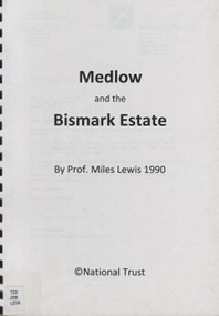 Surrey Hills Historical Society Collection
Book, Medlow and the Bismark Estate by Prof. Miles Lewis, 1990
The Medlow Estate is a remarkable testimony to the unfulfilled expectations of the land boom of the 1880s to early 1890s. The areas of the former lot 14 or the lines of Varzin Avenue and Friedrichsruh Street where they pass through the present grounds will be conserved as may seem appropriate to exhibit the development of the garden in the Cairncross and Bull periods.The Medlow Estate is a remarkable testimony to the unfulfilled expectations of the land boom of the 1880s to early 1890s. The areas of the former lot 14 or the lines of Varzin Avenue and Friedrichsruh Street where they pass through the present grounds will be conserved as may seem appropriate to exhibit the development of the garden in the Cairncross and Bull periods.bismark estate, rosalie estate, conservation of natural resources, (mr) rex swanson, landform australia, cairncross family, medlow, varzin avenue, warrigal road, surrey hills, friedrichsruh street, (mr) (dr) r j bull, (miss) mary jane cairncross, g n taylor -
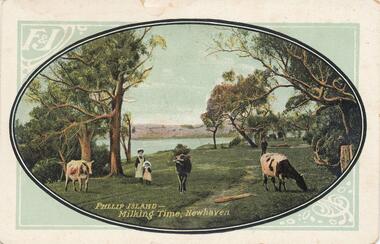 Phillip Island and District Historical Society Inc.
Photograph - Post Card, 1900's
Donated by Jean ParleColoured Postcard of cowes grazing with figures of a woman and child. Sea and land in background."Phillip Island - Milking Time, Newhaven." "F & J"cowes grazing at newhaven, pasture land, phillip island, jean parle -
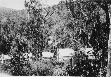 Halls Gap & Grampians Historical Society
Photograph - Sepia, C 1920s
Photo is said to be that of roadmakers camp for workers on the construction of the Mt Victory RoadPhoto shows a number of tents in bush land, said to be road makers campRoad makers camp Mt Victory Rd during the dat 1920sstructures, tents, access routes, road building -
Eltham District Historical Society Inc
Folder, Benjamin Baxter, 1840
Folder of information on Captain Benjamin Baxter, land purchaser, Lower Plenty, 1840benjamin baxter -
Eltham District Historical Society Inc
Folder, Stuart Alexander Donaldson, 1840
Folder of information on Sir Stuart Alexander Donaldson, land purchaser, Montmorency, 1840stuart alexander donaldson -
Glenelg Shire Council Cultural Collection
Photograph - Photograph - Lee B'water / Tanker Berth, n.d
Port of Portland Authority Archivesport of portland archives -
 Bendigo Historical Society Inc.
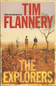
Book - TIM FLANNERY THE EXPLORERS, 1998
Tim Flannery, The Explorers. 385 pages. Major explorers of Australia, sea and land.Tim Flanneryaustralia, history, explorers, exploration of australia, explorers, tim flannery -
 National Vietnam Veterans Museum (NVVM)
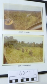
Photograph
Two coloured Photograph in a black frame with titles: "About to land' & "Our passengers".helicopters, photograph -
Port Melbourne Historical & Preservation Society
Letter - Lands & Survey Office re land for football ground, 19 Apr 1880
Letter from Lands & Survey Office regarding land for football ground, 1880sport - australian rules football, sport - recreational grounds, peter gallienne grut, port melbourne football club, pmfc -
Port Melbourne Historical & Preservation Society
Plan - Football Ground, Department of Survey & Lands, 13 May 1880
Plan for Football Ground on land being granted by Department of Survey & Lands, 1880sport - australian rules football, sport - recreational grounds, j kitchen & sons pty ltd, port melbourne football club, pmfc -
 Bendigo Historical Society Inc.
Photograph - 'MARYDALE' AXEDALE COLLECTION: PANORAMIC PHOTO
Panoramic photo of open land with road and bridge, taken from Ingham's Road.axedale, history, marydale property -
Clunes Museum
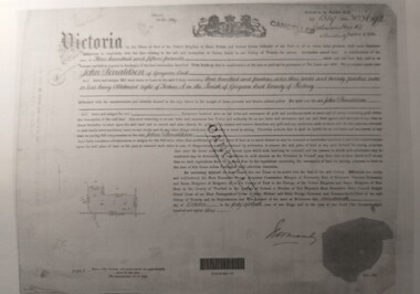
Document - TRANSFER OF LAND
TRANSFER OF LAND FROM P MCRAE TO LACHLAN MCLENNA DATED 10 OCTOBER1871lachlan mclennan, p mcrae -
 Tatura Irrigation & Wartime Camps Museum
Document, Certificate of Payment - John Donaldson
Certificate of payment to John Donaldson, vol 1519 folio 303692, memorials of instruments and titles office record of subdivision.3 pages of copies of original paperwork relating to J Donaldson ownership of land.john donaldson, vol 1519 folio 303692, memorials of instruments, titles office record of subdivision, certificate of payment -
 Whitehorse Historical Society Inc.
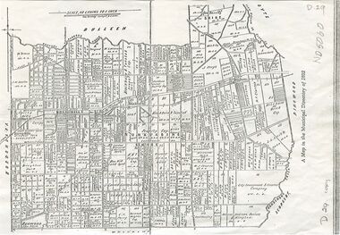
Map, Shire of Nunawading, 1892
Map of the Shire of Nunawading in the Municipal Directory of 1892e of NunawadingPhotocopy of a map of the Shirew of Nunawading in the Municipal Directory of 1892 showing land owners.Map of the Shire of Nunawading in the Municipal Directory of 1892e of Nunawadingmaps, shire of nunawading -
Whitehorse Historical Society Inc.
Legal record - Land Title, Certificate of Title, 19/06/1911
Certificate of Title of land at Lot 6 Subdivision 404 Blackburn on Whitehorse Road.Certificate of Title of land at Lot 6 Subdivision 404 Blackburn on Whitehorse Road.Certificate of Title of land at Lot 6 Subdivision 404 Blackburn on Whitehorse Road.goodwin, william, whitehorse road, blackburn, williams road, blackburn, certificates -
 Whitehorse Historical Society Inc.
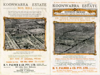
Document - Real Estate Notice, Koonwarra Estate Hatfield's Orchard, C1924
Land brochure giving details of auction of Koonwarra EstateLand brochure giving details of auction of Koonwarra Estate known as Hatfield's OrchardLand brochure giving details of auction of Koonwarra Estate land sales, koonwarra estate, hatfield's orchard, middleborough road, blackburn, canterbury road, laburnum street, hillside crescent, salisbury avenue, rymer street, pakenham street, park street, myrtle grove, h. v. palmer & co. pty. ltd., hiscock, walter g -
 Whitehorse Historical Society Inc.
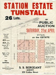
Pamphlet - Document, Station Estate Tunstall, 1923
Land Plan for auction of estate at Tunstall.Land Plan for auction of estate at Tunstall. Original in Haughton Maps, Latrobe LibraryLand Plan for auction of estate at Tunstall. auctions, station estate tunstall, s. s. sergeant (agent) -
Whitehorse Historical Society Inc.
Map, Parish of Nunawading, 1970
[Parish of] Nunawading, County of Bourke. Government Printer Showing original land owners.parish of nunawading, maps, land settlement -
 Port Fairy Historical Society Museum and Archives
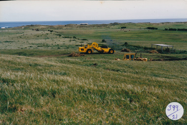
Photograph
South Beach DevelopementColoured photograph of Land works near South Beach with earth moving equipmentsouth beach, development -
 Wangaratta RSL Sub Branch
Photograph, c1940
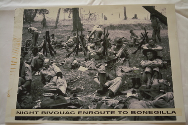
In July 1940, the 2/24th Battalion was formed in Wangaratta. On the 27th September, after weeks of hard training the Battalion marched out to Bonegilla to continue training prior to overseas deployment to the Middle East in November, 1940. This image depicts soldiers resting during the 60 mile march.The 2/24th Battalion was an infantry battalion of the Australian Army, which served during World War II .A unit of all-volunteers, it was formed in July 1940 from primarily Victorian volunteers and was known as "Wangaratta's Own" because of the time the battalion spent in the town during its formative period prior to deployment overseas. It served in North Africa in 1941–1942 as part of the 26th Brigade, which was assigned to the 7th Division, before being reassigned to the 9th Division. In early 1943, the battalion returned to Australia and later took part in campaigns against the Japanese in New Guinea in 1943–1944 and Borneo in 1945, before being disbanded in 1946. The 2/24th suffered the highest number of casualties of any 2nd AIF infantry battalion. The Unit was granted the Freedom of the City by the Rural City of Wangaratta in 1990 and one of the first, if not the first, to receive this type of honour.Reproduced black and white photograph of unknown soldiers sitting on the ground in bush land. Night bivouac enroute to Bonegilla2/24th battalion, wangaratta -
 Ballarat Heritage Services
Photograph - Photograph - Colour, Clare Gervasoni, Agitation Hill, Chewton, 2011, 2011
Colour photograph of the land at Chewton where a goldfields agitation meeting took place.agitation hill chewton, goldfields agitation, chewton