Showing 2320 items matching "melbourne street plan"
-
 St Kilda Historical Society
Photograph - Photo map, 11/01/1968
One of a series of photo-maps produced for the Department of Crown Lands and Survey (1857-1983). For correlation with a current map, and access to other historical photo maps of Victoria, see the Historic Photo-Maps Index published by the Department of Environment, Land, Water and Planning at https://services.land.vic.gov.au/DELWPmaps/historical-photomaps/Black and white aerial photographVic 2132 State Aerial Survey Melbourne 1968 Proj. Run 27E 11.1.68 5100 ASL 69st kilda, albert park, st kilda east, st kilda beach, alma park, windsor, prahran, 1968 -
 St Kilda Historical Society
Photograph - Photo map, 11/01/1968
One of a series of photo-maps produced for the Department of Crown Lands and Survey (1857-1983). For correlation with a current map, and access to other historical photo maps of Victoria, see the Historic Photo-Maps Index published by the Department of Environment, Land, Water and Planning at https://services.land.vic.gov.au/DELWPmaps/historical-photomaps/Black and white aerial photographVic 2132 State Aerial Survey Melbourne 1968 Proj. Run 28E 11.1.68 5100 ASL 81st kilda, balaclava, st kilda east, ripponlea, elwood, elsternwick, caulfield, st kilda botanical gardens, 1968 -
 St Kilda Historical Society
Photograph - Photo map, 11/01/1968
One of a series of photo-maps produced for the Department of Crown Lands and Survey (1857-1983). For correlation with a current map, and access to other historical photo maps of Victoria, see the Historic Photo-Maps Index published by the Department of Environment, Land, Water and Planning at https://services.land.vic.gov.au/DELWPmaps/historical-photomaps/Black and white aerial photographVic 2132 State Aerial Survey Melbourne 1968 Proj. Run 29E 11.1.68 5100 ASL 194elwood, elwood beach, elwood park, elsternwick park, ripponlea, elwood canal, balaclava, st kilda, 1968 -
 St Kilda Historical Society
Photograph - Photo map, 11/01/1968
One of a series of photo-maps produced for the Department of Crown Lands and Survey (1857-1983). For correlation with a current map, and access to other historical photo maps of Victoria, see the Historic Photo-Maps Index published by the Department of Environment, Land, Water and Planning at https://services.land.vic.gov.au/DELWPmaps/historical-photomaps/Black and white aerial photographVic 2132 State Aerial Survey Melbourne 1968 Proj. Run 27E 11.1.68 5100 ASLst kilda, st kilda west, st kilda pier, catani gardens, st kilda beach, albert park, 1968 -
 St Kilda Historical Society
Photograph - Photo map, 11/01/1968
One of a series of photo-maps produced for the Department of Crown Lands and Survey (1857-1983). For correlation with a current map, and access to other historical photo maps of Victoria, see the Historic Photo-Maps Index published by the Department of Environment, Land, Water and Planning at https://services.land.vic.gov.au/DELWPmaps/historical-photomaps/Black and white aerial photographVic 2132 State Aerial Survey Melbourne 1968 Proj. Run 29E 11.1.68 5100 ASL 196elwood, elwood park, elwood canal, elwood beach, st kilda marina, mc moran reserve, point ormond, 1968 -
 St Kilda Historical Society
Photograph - Photo map, Department of Crown Lands and Survey (1857-1983), 22/01/1970
One of a series of photo-maps produced for the Department of Crown Lands and Survey (1857-1983). For correlation with a current map, and access to other historical photo maps of Victoria, see the Historic Photo-Maps Index published by the Department of Environment, Land, Water and Planning at https://services.land.vic.gov.au/DELWPmaps/historical-photomaps/Black and white aerial photographVic 2358 Department of Crown Lands and Survey Victoria,.© Melbourne 1970 Project Run 41E 22.1.70 5,100 ASL 62caulfield, caulfield north, st kilda east, armadale, 1970 -
 St Kilda Historical Society
Photograph - Photo map, 14/12/1963
One of a series of photo-maps produced for the Department of Crown Lands and Survey (1857-1983). For correlation with a current map, and access to other historical photo maps of Victoria, see the Historic Photo-Maps Index published by the Department of Environment, Land, Water and Planning at https://services.land.vic.gov.au/DELWPmaps/historical-photomaps/Black and white aerial photographVic 1807 Melbourne 1963 Project Run 17 14.12.63 Lens 205 152.70 M/M 5.150 36st kilda, st kilda botanical gardens, balaclava, st kilda east, elwood canal, ripponlea, caulfield north, elwood, caulfield, 1963 -
 St Kilda Historical Society
Photograph - Photo map, Department of Crown Lands and Survey (1857-1983), 22/01/1970
One of a series of photo-maps produced for the Department of Crown Lands and Survey (1857-1983). For correlation with a current map, and access to other historical photo maps of Victoria, see the Historic Photo-Maps Index published by the Department of Environment, Land, Water and Planning at https://services.land.vic.gov.au/DELWPmaps/historical-photomaps/Black and white aerial photographVic 2358 Department of Crown Lands and Survey Victoria,.© Melbourne 1970 Project Run 42E 22.1.70 5,100 ASL 77st kilda, st kilda east, st kilda marina, elwood, elwood canal, elsternwick park, point ormond, balaclava, mc moran reserve, ripponlea, st kilda botanical gardens, peanut farm, 1970 -
 St Kilda Historical Society
Photograph - Photo map, Department of Crown Lands and Survey, 22/01/1970
One of a series of photo-maps produced for the Department of Crown Lands and Survey (1857-1983). For correlation with a current map, and access to other historical photo maps of Victoria, see the Historic Photo-Maps Index published by the Department of Environment, Land, Water and Planning at https://services.land.vic.gov.au/DELWPmaps/historical-photomaps/Black and white aerial photographVic 2358 Department of Crown Lands and Survey Victoria,.© Melbourne 1970 Project Run 43E 22.1.70 5,100 ASL 208elwood, elwood beach, point ormond, elwood park, elwood canal, mc moran reserve, 1970 -
 St Kilda Historical Society
Photograph - Photo map, Department of Crown Lands and Survey, 22/01/1970
One of a series of photo-maps produced for the Department of Crown Lands and Survey (1857-1983). For correlation with a current map, and access to other historical photo maps of Victoria, see the Historic Photo-Maps Index published by the Department of Environment, Land, Water and Planning at https://services.land.vic.gov.au/DELWPmaps/historical-photomaps/Black and white aerial photographCONTROLLED Vic 2358 Department of Crown Lands and Survey Victoria,.© Melbourne 1970 Project Run 41E 22.1.70 5,100 ASL 66st kilda, albert park, st kilda west, catani gardens, st kilda botanical gardens, st kilda pier, st kilda beach, 1970 -
 St Kilda Historical Society
Photograph - Photo map, Department of Crown Lands and Survey, 22/01/1970
One of a series of photo-maps produced for the Department of Crown Lands and Survey (1857-1983). For correlation with a current map, and access to other historical photo maps of Victoria, see the Historic Photo-Maps Index published by the Department of Environment, Land, Water and Planning at https://services.land.vic.gov.au/DELWPmaps/historical-photomaps/Black and white aerial photographVic 2358 Department of Crown Lands and Survey Victoria,.© Melbourne 1970 Project Run 42E 22.1.70 5,100 ASL 75st kilda, st kilda beach, st kilda marina, point ormond, st kilda pier, 1970 -
 St Kilda Historical Society
Photograph - Photo map, 14/12/1963
One of a series of photo-maps produced for the Department of Crown Lands and Survey (1857-1983). For correlation with a current map, and access to other historical photo maps of Victoria, see the Historic Photo-Maps Index published by the Department of Environment, Land, Water and Planning at https://services.land.vic.gov.au/DELWPmaps/historical-photomaps/Black and white aerial photographVic 1807 Melbourne 1963 Project Run 16 14.12.1963 Lens 205 152.70 M/M 5.150 177st kilda, st kilda pier, catani gardens, middle park, albert park, st kilda west, st kilda beach, 1963 -
 St Kilda Historical Society
Photograph - Photo map, Department of Crown Lands and Survey, 22/01/1970
One of a series of photo-maps produced for the Department of Crown Lands and Survey (1857-1983). For correlation with a current map, and access to other historical photo maps of Victoria, see the Historic Photo-Maps Index published by the Department of Environment, Land, Water and Planning at https://services.land.vic.gov.au/DELWPmaps/historical-photomaps/Black and white aerial photographVic 2358 Department of Crown Lands and Survey Victoria,.© Melbourne 1970 Project Run 41E 22.1.70 5,100 ASL 64st kilda, st kilda cemetery, balaclava, st kilda east, windsor, caulfield north, alma park, 1970 -
 St Kilda Historical Society
Photograph - Photo map, Department of Crown Lands and Survey, 08/01/1970
One of a series of photo-maps produced for the Department of Crown Lands and Survey (1857-1983). For correlation with a current map, and access to other historical photo maps of Victoria, see the Historic Photo-Maps Index published by the Department of Environment, Land, Water and Planning at https://services.land.vic.gov.au/DELWPmaps/historical-photomaps/Black and white arial photographVic 2345 Department of Crown Lands and Survey Victoria,.© Melbourne 1970 Project Run 40 8.1.70 5,100 ASL 77albert park, fawkner park, south yarra, middle park, prahran, windsor, st kilda, st kilda west, 1970 -
 St Kilda Historical Society
Photograph - Photo map, 22/01/1970
One of a series of photo-maps produced for the Department of Crown Lands and Survey (1857-1983). For correlation with a current map, and access to other historical photo maps of Victoria, see the Historic Photo-Maps Index published by the Department of Environment, Land, Water and Planning at https://services.land.vic.gov.au/DELWPmaps/historical-photomaps/Black and white aerial photographVic 2358 Department of Crown Lands and Survey Victoria,.© Melbourne 1970 Project Run 43E 22.1.70 5,100 ASL 206elwood, elsternwick, elsternwick park, 1970 -
 St Kilda Historical Society
Photograph, Christ Church St Kilda exterior - images collection #2
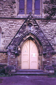
Christ Church was constructed in 1854-57 and designed in Decorated Gothic style by Albert Purchase & Charles Swyer. It was enlarged in 1874 and 1881 to the designs of Sydney W Smith. It is one of four main buildings constructed on land granted to the Church of England in 1855 and named Church Square. The other buildings are the bishop's residence, vicarage and parish hall. Heritage Victoria describes it as a 'rare and significant square in the history of town planning in Victoria which demonstrates the importance of the church to the community'. It is built from rarely used undressed random coursed sandstone from Point King Sorrento. It is located at 14 Acland Street, St Kilda. The triangular rose window is said to have been modelled on Lichfield Cathedral and shows outstanding craftsmanship. According to Heritage Victoria, the only other known example in Victoria is at St Georges Presbyterian Church in East St Kilda, designed by the same architect, Albert Purchas. The Church has a varied collection of stained glass, including work by leading stained glass firms and artists in Victoria in the nineteenth and early twentieth century: Ferguson & Urie, William Montgomery and Brooks Robinson. The 'shipwreck window,' north west transept, is an historically significant memorial window dedicated to Miles and William Dalzell Nicholson, the second and third sons of the Hon. William Nicholson, M.L.A, a Lord Mayor of Melbourne and Premier of Victoria in the 1850s. Miles, died in England on 27 April 1874. His younger brother William died in the wreck of the ‘British Admiral’ off King Island on 23 May 1874. The images show the condition of the church at the time they were taken (c 2012). Signs of deterioration can be seen. The bell is not rung any more because of damage to the stonework.There has been some remedial work since and the National Trust of Australia conducted a heritage restoration appeal.churches, acland street, purchase, swyer, st kilda, christ church -
 St Kilda Historical Society
Document, Plan of Town of Melbourne 1837 AD, 1837 (original)
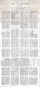
Shows the outcome of the first land sales held in Melbourne, on 1 June and 1 November 1837. All the names and prices for each lot are displayed.Photocopy of "Plan of Town of Melbourne 1837 A.D." showing first land sales.All lots printed with name of buyer and price paid.melbourne - history, town of melbourne- 1837, 19th century -
 St Kilda Historical Society
Plan - Architectural drawing, Competitive Design St Kilda War Memorial, c1923
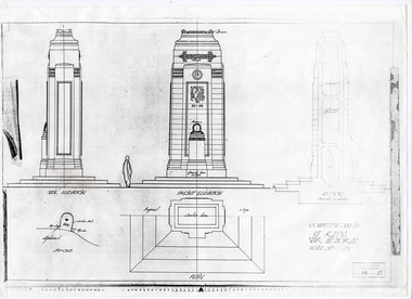
Photocopy of extract of the winning design for the St Kilda War Memorial. The architect was G H Alsop who, at 21 years of age and with Assisting Architect JC Aisbell, won a competition to design the memorial to St Kilda's fallen servicemen and women. The memorial was unveiled in 1925.White paper, printed in black on one sidest kilda war memorial, st kilda cenotaph, catani gardens -
 St Kilda Historical Society
Ephemera - Invitation, Illustrated Public Lecture, 1954
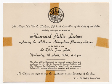
Invitation to a lecture on the Melbourne Metropolitan Planning Scheme, presented by the City of St Kilda, at the St Kilda Town Hall at 8pm on 7 April 1954. The lecture was to be illustrated by 'coloured lantern slides' and followed by a screening of the film 'Planning for Melbourne's Future'. The Melbourne Metropolitan Planning Scheme 1954: Report, compiled by the then Melbourne and Metropolitan Board of Work, began the planning system for Melbourne. It planned for a population of 2.5 million in the 1990s, a population actually reached in the 1970s. .White card printed in black on one sidemelbourne metropolitan planning scheme, town planning, planning -
 St Kilda Historical Society
Photograph, 22 November 1933
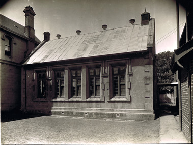
This school was one of the earliest in St Kilda. The 1842 plan of Crown Lands that were sold to establish what became the village of St Kilda reserved an area on Acland Street for the 'Church of England and School'. Christ Church was constructed on the site in 1854-57. A school had started before then but was closed for about a year after the Head Teacher abandoned his students in search of gold. A sign on the door read 'This school is closed in consequence of the master having gone to the diggings'. The school was re-opened in 1853, with only two pupils on the first day. The new Headmaster was John Hadfield, a teacher who had recently arrived in Melbourne from Wiltshire, England. He stayed on as Headmaster for the next 22 years. Free secular compulsory education was introduced in Victoria from 1873. Until a permanent State school could be built in the area, the Government used the St Kilda Town Hall for this purpose, and the students from Christ Church school were transferred there. The Brighton Road State School was opened in January 1875, with John Hadfield was its first Headmaster. The Government then leased the old Christ Church schoolroom and established a second school there. The Headmaster was James A Ure. The school continued until the 1940s. The building was burnt down in 1977.The building burnt down in 1977.black and white gloss photograph good condition unmountedFirst State School in St Kilda, Acland St, St Kilda 22 Nov 1933st kilda, christ church, acland street, st kilda schools, john hadfield, james a ure, christ church school, christ church college -
 St Kilda Historical Society
Photograph, c. 1865?
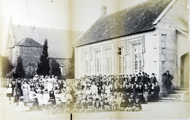
This school was one of the earliest in St Kilda. The 1842 plan of Crown Lands that were sold to establish what became the village of St Kilda reserved an area on Acland Street for the 'Church of England and School'. Christ Church was constructed on the site in 1854-57. A school had started before then but was closed for about a year after the Head Teacher abandoned his students in search of gold. A sign on the door read 'This school is closed in consequence of the master having gone to the diggings'. The school was re-opened in 1853, with only two pupils on the first day. The new Headmaster was John Hadfield, a teacher who had recently arrived in Melbourne from Wiltshire, England. He stayed on as Headmaster for the next 22 years. Free secular compulsory education was introduced in Victoria from 1873. Until a permanent State school could be built in the area, the Government used the St Kilda Town Hall for this purpose, and the students from Christ Church school were transferred there. The Brighton Road State School was opened in January 1875, with John Hadfield was its first Headmaster. The Government then leased the old Christ Church schoolroom and established a second school there. The Headmaster was James A Ure. The school continued until the 1940s. The building was burnt down in 1977.The building burnt down in 1977.Framed and mounted original photograph, black and white. First state school room in Victoria.st kilda, christ church, acland street, st kilda schools, john hadfield, james a ure, christ church school, christ church college -
 Clunes Museum
Booklet - WESLEY COLLEGE
SPIRAL BOUND BOOKLET. CONTAINING DETAILS OF THE PLANNING OF THE CLUNES CAMPUSwesley college, daryl jackson architects -
Clunes Museum
Document - DOCUMENT POSTER, JEANETTE SPITTLE - UNIVERSITY OF MELBOURNE BURNLEY CAMPUS, QUEENS PARK CLUNES - A MANAGEMENT REVIEW
LAMINATED MANAGEMENT REVIEW FOR QUEENS PARK CLUNES. SHOWING MASTER PLAN. COMPLETED 2006. JEANETTE SPITTLEqueens park, clunes, management review, regional botanic gardens -
Tatura Irrigation & Wartime Camps Museum
Document, Eric Eckstein, Dunera News- August 1990, August 1990
The planning of the 50th anniversary of the Dunera Boys and a look back of the history to be held in September in Melbourne, Sydney and Hay.In a clear plastic folder - Dunera News Number 17 August 1990. Above drawing of the Dunera 1940 - 1990, 50th Anniversary. Hay. Fred Lowen A.M on what would be the back page - a drawing of an internment camp Taturaas abovedunera, 50th anniversary reunion -
Tatura Irrigation & Wartime Camps Museum
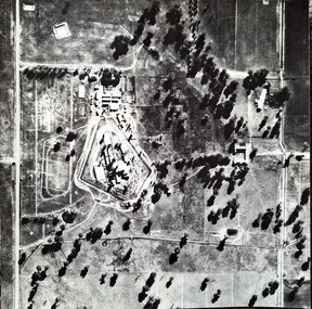
Photograph, Central Planning Office, Camp 2 aerial, 1989
Black and white aerial photo of camp 2on the back: camp 2 W/c 0065 Vic 82/.9032 Max 1989 Central Planning Office Treasury Place Melbourne -
 Tatura Irrigation & Wartime Camps Museum
Photograph, Aerial Photograph Dhurringile Mansion, 1940
Dhurringile POW camp aerial photograph. Obtain May 1989 from the Historic Photographs Department, Treasury Place, Melbourne (Central Planning Office). Black and white photograph. Aerial photo of Dhurringile Camp and surrounding area. North is at top of picture.dhurringile pow camp, dhurringile aerial photo -
 Williamstown High School
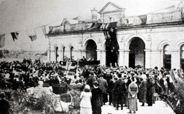
1915 - School opening
Depicts the original quadrangle building, decked out with celebratory flags. A large crowd listens to the dignitaries as the school is officially opened. The English flag can be seen in the crowd.2 copies: 1 copy of a black and white photograph of the original 1867 building mounted on board. 1 laminated copy of photograph. Accompanied by 2 captions. See also: 32.11 - original sepia photograph.Official opening of school from High Tide 1915. Caption 1 reads: In 1914 control passed to the education Department. Buildings were renovated and plans executed for two pre-fabricated buildings as a temporary measure. Caption 2 reads: In 1867 the Williamstown Borough Grammar Achool was situated on the corner of Pasco Street and Verdon Street Williamstown. Back of original sepia photograph: Official opening of the school 1921. (see photograph above.)williamstown high school, 1915, school opening -
 Robin Boyd Foundation
Slide, Robin Boyd
Colour slide in a mount. Image of the sketch plan of the Desbrowe Annear House (in Robin Boyd's handwriting), 36-38 The Eyrie, Eaglemont, Victoria, Australia (1903)Made in Australia / Encircled 37 (Handwritten) / Encircled A (Handwritten)slide, robin boyd -
 Uniting Church Archives - Synod of Victoria
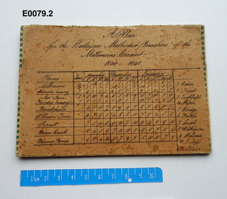
Plan - Circuit plan, A Plan for the Wesleyan Methodist Preachers of the Melbourne Circuit 1840 - 1841
Wesleyan Methodist Preachers: Orton, Hurst, Tuckfield, Witton, Dredge, Parker, Smith, Wilkinson, Willard, Topp, Stone.Tan coloured card with handwritten title and table which gives the places, dates and Preacher's names in black ink copperplate writing.wesleyan methodist melbourne circuit -
 Uniting Church Archives - Synod of Victoria
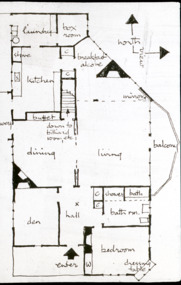
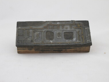
Photographic print block
Glen Iris Presbyterian Church on the corner of High Street and Allison Avenue. Floor plan of church hall in Allison Avenue show PFA Club Rm, Kitchen, Foyer, Entry, Stage, Hall and Class room."5"glen iris presbyterian church