Showing 810 items matching " aerial views"
-
 Glenelg Shire Council Cultural Collection
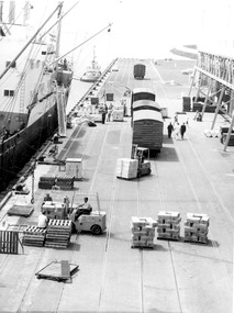
Photograph - Photograph - frozen goods loaded onto ship, n.d
... a ship - aerial view.... - aerial view. Photograph Photograph - frozen goods loaded onto ...Port of Portland Authority archivesFront: (no inscriptions) Back: (no inscriptions)port of portland archives, cargo, cargo handling, portland harbour -
 Glenelg Shire Council Cultural Collection
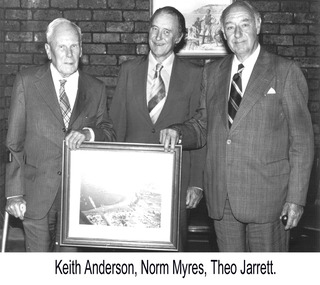
Photograph - Photograph - Keith Andersen, Norman Myers and Theo Jarrett, n.d
... Three men holding framed photograph depicting an aerial... framed photograph depicting an aerial view of the Port ...Port of Portland Authority archivesFront: (no inscriptions) Back: Commissioner/ Keith Andersen Norm Myers Theo Jarrett/ Chairman (blue pen, lower centre)port of portland authority archives -
 Glenelg Shire Council Cultural Collection
Photograph - Photograph - View of Pivot fertiliser works, c. 1972
... Black and white photograph. Aerial view of Pivot Fertiliser...: (no inscriptions) Back: PIVOT Black and white photograph. Aerial view ...Port of Portland Authority archives.Front: (no inscriptions) Back: PIVOTport of portland archives -
 Robin Boyd Foundation
Slide, Robin Boyd, 1966
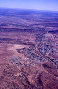
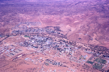
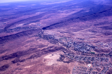
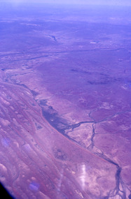
... Colour slide in a mount. Aerial view of Alice Springs... slide in a mount. Aerial view of Alice Springs, Northern ...Robin Boyd was appointed Exhibits Architect for the Australian Pavilion at Expo ‘67 in Montreal. In 1966 Boyd travelled to Far North Queensland and the Northern Territory for research – the Expo exhibits included a coral display, a large rock feature made from Australian sandstone and a native plant garden.Colour slide in a mount. Aerial view of Alice Springs, Northern Territory, AustraliaMade in Australia / 10 / DEC 66M4australia, slide, robin boyd -
 Robin Boyd Foundation
Slide, Robin Boyd, 1966
... Colour slide in a mount. Aerial view of Alice Springs... slide in a mount. Aerial view of Alice Springs, Northern ...Robin Boyd was appointed Exhibits Architect for the Australian Pavilion at Expo ‘67 in Montreal. In 1966 Boyd travelled to Far North Queensland and the Northern Territory for research – the Expo exhibits included a coral display, a large rock feature made from Australian sandstone and a native plant garden.Colour slide in a mount. Aerial view of Alice Springs, Northern Territory, AustraliaMade in Australia / 11 / DEC 66M4northern territory, slide -
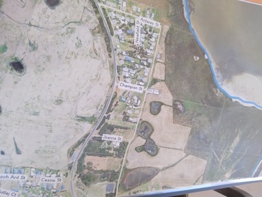 Peterborough History Group
Plan - Moyne Shire Council Aerial photograph, Department of Sustainability and Environment, January 2018
... aerial view...A3 size copy of an aerial view of the majority of the town... peterborough aerial view A3 size copy of an aerial view of the majority ...View shows development at the time and showing the town boundary using Vicmap InformationSignificant in that it provides a record of the current state of development of the town. Also, a view of the estuary at that time.A3 size copy of an aerial view of the majority of the town with street names mentioned. curdies river inlet, peterborough, aerial view -
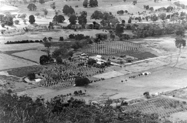 Stawell Historical Society Inc
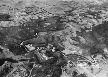
Photograph, Cox’s Orchard at Mt Cassell in Pomonal
... Black and white aerial view of property with orchards... property. Black and white aerial view of property with orchards ...Cox’s Orchard from Mt Cassell at Springtime Pomonal.Black and white aerial view of property with orchards and cleared paddocks. In the background is a roadway.Taken from Mt Cassell Vicinity Cove Rock. Telephoto. Cox property.stawell -
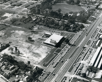 Whitehorse Historical Society Inc.
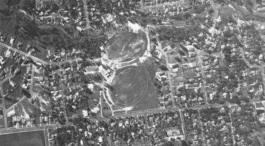
Photograph, Nunawading Civic Centre
... Black and white photo of aerial view of Nunawading Civic... Black and white photo of aerial view of Nunawading Civic Centre ...Black and white photo of aerial view of Nunawading Civic Centre. 1 copynunawading civic centre, whitehorse civic centre -
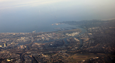 Ballarat Heritage Services
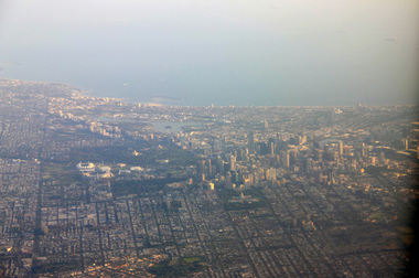
Photograph, L.J. Gervasoni, Mouth of the Yarra River from the air, 2016
... Digital Image showing an aerial view of the mouth... Image showing an aerial view of the mouth of the Yarra River ...Digital Image showing an aerial view of the mouth of the Yarra River from the airaerial, melbourne, mouth, yarra, river, port phillip bay, flemington, docklands, bolte bridge, west gate bridge -
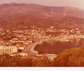 Ithacan Historical Society
Photograph, View of Vathi, Ithaca, circa 1970's
... A discoloured photograph and aerial view of the port... Harbours A discoloured photograph and aerial view of the port ...View of the Ithaca's capital town Vathi and its harbour, located in south of the island.A discoloured photograph and aerial view of the port of Vathi and surrounding settlement, with the mountains in the background.ports, harbours -
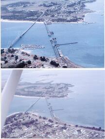 Phillip Island and District Historical Society Inc.
Photographs/Slides, Laurie Dixon, 1960's
... aerial views. 273-01. Aerial view of the old and new bridges.... Three aerial views. 273-01. Aerial view of the old and new ...Four of a collection of slides taken by Laurie Dixon. (Scanned by E Alexander) The new bridge was built in 1968.Four coloured photographs scanned from slides. Three aerial views. 273-01. Aerial view of the old and new bridges and Newhaven, San Remo and Churchill Island - extra close up of same photo. 273-02. Aerial view of the old and new bridges looking towards Cape Woolamai on the top right. 273-03. Aerial view of the Cowes Pier and township - extra close up of same photo. 273-04. Looking down the Cowes Pier towards the township with Isle of Wight Hotel in the background.273-03. Inscription on the slide: Cowes from the air Jan 1968.phillip island suspension bridge, two bridges phillip island, san remo, newhaven, laurie dixon, cowes pier, cowes pier phillip island -
Port Melbourne Historical & Preservation Society
Photograph - Aerial view Webb Dock and Beacon Cove site, Port Melbourne, 6 Sep 1997
... Aerial view Webb Dock and Beacon Cove site, Port Melbourne...(.01) Aerial photographic view of Webb Dock - September... photographic view of Webb Dock - September 1997 (.02) Aerial view ...(.01) Aerial photographic view of Webb Dock - September 1997 (.02) Aerial view of cleared site for future Beacon Cove project - September 1997piers and wharves - webb dock, built environment, beacon cove -
Glenelg Shire Council Cultural Collection
Photograph, Photograph Reclamation and Canal Work, 1959
... Front: General view: Aerial view West showing wharf... Authority Archives Port of Portland Front: General view: Aerial view ...Port of Portland Authority ArchivesFront: General view: Aerial view West showing wharf and canal areas. November 1959 - typed.port of portland -
 Ringwood and District Historical Society
Photograph, Aerial view taken from slide - Ringwood Lake and surrounds 1969
... Aerial view taken from slide - Ringwood Lake and surrounds...Written on plastic sleeve, "Aerial view taken from slide..., "Aerial view taken from slide - Ringwood Lake 7/8/69". Aerial view ...Written on plastic sleeve, "Aerial view taken from slide - Ringwood Lake 7/8/69". -
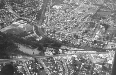
 Federation University Historical Collection
Photograph - Colour Photograph, Aerial View of Mt Clear, 1985, 1985
... Aerial View of Mt Clear, 1985...Aerial View of Mt Clear showing Mt Clear Technical School... clear mount clear TEchncial School canadian Creek Aerial View ...Aerial View of Mt Clear showing Mt Clear Technical School and Canadian Creek.mount clear, mount clear techncial school, canadian creek -
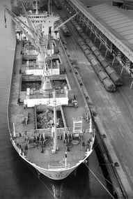
 Glenelg Shire Council Cultural Collection
Photograph - Photograph - Unknown cargo ship, aerial view, n.d
... Photograph - Unknown cargo ship, aerial view...Aerial view of cargo ship berthed at a wharf. Contents...: (no inscriptions) Back: (no inscriptions) Aerial view of cargo ship berthed ...Port of Portland Authority archives.Front: (no inscriptions) Back: (no inscriptions)port of portland archives -
 Eltham District Historical Society Inc
Photograph, Aerial view of Yarra River near Kangaroo Ground - Bend of Islands area
... Aerial view of Yarra River near Kangaroo Ground - Bend of...Sepia aerial view of Yarra river at Bend of Islands; Henley... Sepia aerial view of Yarra river at Bend of Islands; Henley Road ...Sepia aerial view of Yarra river at Bend of Islands; Henley Road on left in foregroundbend of isles, kangaroo ground, yarra river, henley road -
 Ringwood and District Historical Society
Photograph, Aerial view showing Mullum Ovals 1 and 2, Mullum Road. c.1970
... Aerial view showing Mullum Ovals 1 and 2, Mullum Road. c...Aerial view showing Mullum Ovals 1 and 2, Mullum Road. c... Road Ringwood North melbourne Aerial view showing Mullum Ovals ...Aerial view showing Mullum Ovals 1 and 2, Mullum Road. c.1970. -
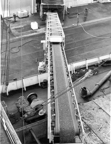 Glenelg Shire Council Cultural Collection
Photograph - Photograph - aerial view of Lucerne pellets loaded onto ship, 1972
... Photograph - aerial view of Lucerne pellets loaded onto...Aerial view of Lucerne pellets for the Japanese market...: (no inscriptions) Aerial view of Lucerne pellets for the Japanese market ...Port of Portland Authority archivesFront: (no inscriptions) Back: (no inscriptions)port of portland archives, cargo, cargo handling, portland harbour, japanese cargo -
Glenelg Shire Council Cultural Collection
Photograph - Photograph - View of Portland Harbour, c. 1974
... Black and white photograph. Aerial view taken from.... Aerial view taken from the north, Portland Harbour. Unframed ...Port of Portland Authority archives.Front: (no inscriptions) Back: (no inscriptions)port of portland archives, portland harbour -
 Robin Boyd Foundation
Slide, Robin Boyd, 1966
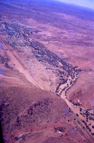
... Colour slide in a mount. Aerial view over Alice, Springs... / Encircled 78 (Handwritten) Colour slide in a mount. Aerial view over ...Robin Boyd was appointed Exhibits Architect for the Australian Pavilion at Expo ‘67 in Montreal. In 1966 Boyd travelled to Far North Queensland and the Northern Territory for research – the Expo exhibits included a coral display, a large rock feature made from Australian sandstone and a native plant garden.Colour slide in a mount. Aerial view over Alice, Springs, Northern Territory, AustraliaMade in Australia / 9 / DEC 66M4 / Encircled 78 (Handwritten)australia, slide, robin boyd -
 Robin Boyd Foundation
Slide, Robin Boyd, 1966
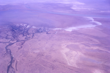
... Colour slide in a mount. Aerial view on the way to Alice... / Encircled 3 (Handwritten) Colour slide in a mount. Aerial view ...Robin Boyd was appointed Exhibits Architect for the Australian Pavilion at Expo ‘67 in Montreal. In 1966 Boyd travelled to Far North Queensland and the Northern Territory for research – the Expo exhibits included a coral display, a large rock feature made from Australian sandstone and a native plant garden.Colour slide in a mount. Aerial view on the way to Alice Springs, Northern Territory, AustraliaMade in Australia / 32 / DEC 66M4 / Encircled 3 (Handwritten)australia, slide, robin boyd -
 Robin Boyd Foundation
Slide, Robin Boyd, 1966
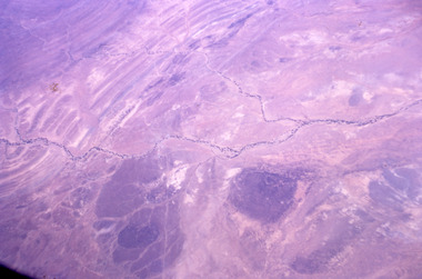
... Colour slide in a mount. Aerial view on the way to Alice... slide in a mount. Aerial view on the way to Alice Springs ...Robin Boyd was appointed Exhibits Architect for the Australian Pavilion at Expo ‘67 in Montreal. In 1966 Boyd travelled to Far North Queensland and the Northern Territory for research – the Expo exhibits included a coral display, a large rock feature made from Australian sandstone and a native plant garden.Colour slide in a mount. Aerial view on the way to Alice Springs, Northern Territory, AustraliaMade in Australia / 12 / DEC 66M4northern territory, slide -
 Robin Boyd Foundation
Slide, Robin Boyd, 1966
... Colour slide in a mount. Aerial view on the way to Alice... slide in a mount. Aerial view on the way to Alice Springs ...Robin Boyd was appointed Exhibits Architect for the Australian Pavilion at Expo ‘67 in Montreal. In 1966 Boyd travelled to Far North Queensland and the Northern Territory for research – the Expo exhibits included a coral display, a large rock feature made from Australian sandstone and a native plant garden.Colour slide in a mount. Aerial view on the way to Alice Springs, Northern Territory, AustraliaMade in Australia / 33 / DEC 66M4northern territory, slide -
 Robin Boyd Foundation
Slide, Robin Boyd, 1966
... Colour slide in a mount. Aerial view on the way to Alice... slide in a mount. Aerial view on the way to Alice Springs ...Robin Boyd was appointed Exhibits Architect for the Australian Pavilion at Expo ‘67 in Montreal. In 1966 Boyd travelled to Far North Queensland and the Northern Territory for research – the Expo exhibits included a coral display, a large rock feature made from Australian sandstone and a native plant garden.Colour slide in a mount. Aerial view on the way to Alice Springs, Northern Territory, AustraliaMade in Australia / 34 / DEC 66M4northern territory, slide -
 Robin Boyd Foundation
Slide, Robin Boyd, 1966
... Colour slide in a mount. Aerial view on the way to Alice... slide in a mount. Aerial view on the way to Alice Springs ...Robin Boyd was appointed Exhibits Architect for the Australian Pavilion at Expo ‘67 in Montreal. In 1966 Boyd travelled to Far North Queensland and the Northern Territory for research – the Expo exhibits included a coral display, a large rock feature made from Australian sandstone and a native plant garden.Colour slide in a mount. Aerial view on the way to Alice Springs, Northern Territory, AustraliaMade in Australia / 8 / DEC 66M4northern territory, slide -
 Ballarat Heritage Services
Digital Photograph, L.J. Gervasoni, Melbourne CBD and Albert Park Lake on approach Melbourne Airport, 2016
... Digital Image showing an aerial view of the Melbourne... lake port phillip bay Digital Image showing an aerial view ...Digital Image showing an aerial view of the Melbourne Central Business District and Albert Park.aerial, melbourne, yarra river, cbd, albert park, lake, port phillip bay -
 Ballarat Heritage Services
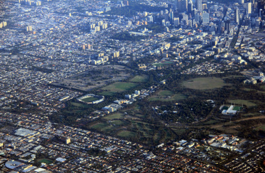
Digital Photograph, L.J. Gervasoni, Royal Park CBD and zoo from the air, 2016
... Digital Image showing an aerial view of the Melbourne... Digital Image showing an aerial view of the Melbourne Central ...Digital Image showing an aerial view of the Melbourne Central Business District and Royal Park.aerial, melbourne, yarra river, cbd, royal park, zoo -
 Ballarat Heritage Services
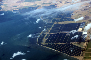
Digital Photograph, L.J. Gervasoni, werribee farm from the air, 2016
... Digital Image showing an aerial view of the Melbourne... Image showing an aerial view of the Melbourne Central Business ...Digital Image showing an aerial view of the Melbourne Central Business District and Royal Park.aerial, melbourne, werribee farm, sewerage