Showing 438 items matching " brick home"
-
 Eltham District Historical Society Inc
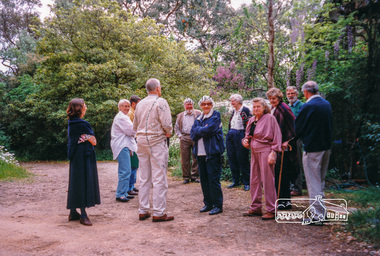
Photograph, Peter Bassett-Smith, Eltham Mud Brick Heritage Excursion, 4 October 1998, 04/10/1998
[article in EDHS Newsletter No. 123, November 1998:] MUD BRICK HERITAGE EXCURSION AND THE FUTURE. A small group of members attended the excursion on 4th October. We visited a number of earth houses listed by the Eltham Heritage Study in a very pleasant day's outing. The first visit was to the home of Jenny and Brian Ellis in York Street, formerly the home of Jenny's father Professor William McMahon Ball. We were made very welcome with inspection of the inside and outside showing the various stages of construction. We then walked through the grounds of "Kinloch", the Jelbart property in Arthur Street where we saw their large mud brick house and barn. Lunch was at Marion and Russell Yeoman's house in Peter Street. This pise house was built by the Moore family in the early 1950's. In the afternoon we visited the home of artist Jenni Mitchell in Fordhams Road, one of the last examples of the work of Alistair Knox. Then we travelled to Laughing Waters Road where we saw two interesting houses owned and built by well known landscape gardener Gordon Ford. Along the way we stopped to view a number of other properties from the street.Colour photographactivities, eltham, heritage excursion, mud brick -
 Eltham District Historical Society Inc
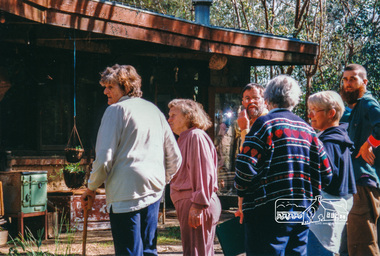
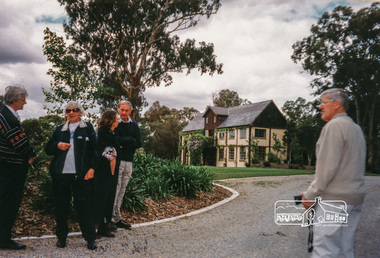
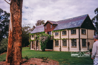
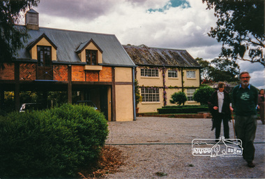
Photograph, Peter Bassett-Smith, Boomerang House, Laughing Waters Road, Eltham; Eltham Mud Brick Heritage Excursion, 4 October 1998, 04/10/1998
[article in EDHS Newsletter No. 123, November 1998:] MUD BRICK HERITAGE EXCURSION AND THE FUTURE. A small group of members attended the excursion on 4th October. We visited a number of earth houses listed by the Eltham Heritage Study in a very pleasant day's outing. The first visit was to the home of Jenny and Brian Ellis in York Street, formerly the home of Jenny's father Professor William McMahon Ball. We were made very welcome with inspection of the inside and outside showing the various stages of construction. We then walked through the grounds of "Kinloch", the Jelbart property in Arthur Street where we saw their large mud brick house and barn. Lunch was at Marion and Russell Yeoman's house in Peter Street. This pise house was built by the Moore family in the early 1950's. In the afternoon we visited the home of artist Jenni Mitchell in Fordhams Road, one of the last examples of the work of Alistair Knox. Then we travelled to Laughing Waters Road where we saw two interesting houses owned and built by well known landscape gardener Gordon Ford. Along the way we stopped to view a number of other properties from the street.Colour photographactivities, eltham, heritage excursion, mud brick, boomerang house, laughing waters road -
 Eltham District Historical Society Inc
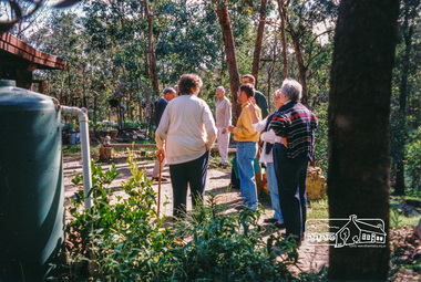
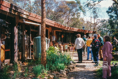
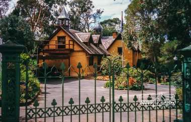
Photograph, Peter Bassett-Smith, Rocknall, 25 Diamond Street, Eltham; Eltham Mud Brick Heritage Excursion, 4 October 1998, 04/10/1998
[article in EDHS Newsletter No. 123, November 1998:] MUD BRICK HERITAGE EXCURSION AND THE FUTURE. A small group of members attended the excursion on 4th October. We visited a number of earth houses listed by the Eltham Heritage Study in a very pleasant day's outing. The first visit was to the home of Jenny and Brian Ellis in York Street, formerly the home of Jenny's father Professor William McMahon Ball. We were made very welcome with inspection of the inside and outside showing the various stages of construction. We then walked through the grounds of "Kinloch", the Jelbart property in Arthur Street where we saw their large mud brick house and barn. Lunch was at Marion and Russell Yeoman's house in Peter Street. This pise house was built by the Moore family in the early 1950's. In the afternoon we visited the home of artist Jenni Mitchell in Fordhams Road, one of the last examples of the work of Alistair Knox. Then we travelled to Laughing Waters Road where we saw two interesting houses owned and built by well known landscape gardener Gordon Ford. Along the way we stopped to view a number of other properties from the street.Colour photographactivities, eltham, heritage excursion, mud brick, diamond street, rocknall -
 Eltham District Historical Society Inc
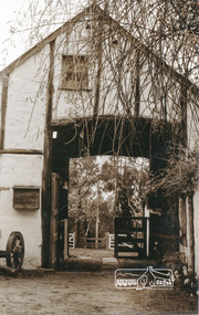
Photograph, Peter Bassett-Smith, Jelbart property, Arthur Street, Eltham Mud Brick Heritage Excursion, 4 October 1998, 04/10/1998
[article in EDHS Newsletter No. 123, November 1998:] MUD BRICK HERITAGE EXCURSION AND THE FUTURE. A small group of members attended the excursion on 4th October. We visited a number of earth houses listed by the Eltham Heritage Study in a very pleasant day's outing. The first visit was to the home of Jenny and Brian Ellis in York Street, formerly the home of Jenny's father Professor William McMahon Ball. We were made very welcome with inspection of the inside and outside showing the various stages of construction. We then walked through the grounds of "Kinloch", the Jelbart property in Arthur Street where we saw their large mud brick house and barn. Lunch was at Marion and Russell Yeoman's house in Peter Street. This pise house was built by the Moore family in the early 1950's. In the afternoon we visited the home of artist Jenni Mitchell in Fordhams Road, one of the last examples of the work of Alistair Knox. Then we travelled to Laughing Waters Road where we saw two interesting houses owned and built by well known landscape gardener Gordon Ford. Along the way we stopped to view a number of other properties from the street.Colour photographactivities, eltham, heritage excursion, mud brick, arthur street, jelbart property -
 Eltham District Historical Society Inc
Photograph, Peter Bassett-Smith, Cottage, Main Road, Eltham, Eltham Mud Brick Heritage Excursion, 4 October 1998, 04/10/1998
[article in EDHS Newsletter No. 123, November 1998:] MUD BRICK HERITAGE EXCURSION AND THE FUTURE. A small group of members attended the excursion on 4th October. We visited a number of earth houses listed by the Eltham Heritage Study in a very pleasant day's outing. The first visit was to the home of Jenny and Brian Ellis in York Street, formerly the home of Jenny's father Professor William McMahon Ball. We were made very welcome with inspection of the inside and outside showing the various stages of construction. We then walked through the grounds of "Kinloch", the Jelbart property in Arthur Street where we saw their large mud brick house and barn. Lunch was at Marion and Russell Yeoman's house in Peter Street. This pise house was built by the Moore family in the early 1950's. In the afternoon we visited the home of artist Jenni Mitchell in Fordhams Road, one of the last examples of the work of Alistair Knox. Then we travelled to Laughing Waters Road where we saw two interesting houses owned and built by well known landscape gardener Gordon Ford. Along the way we stopped to view a number of other properties from the street.Colour photographactivities, eltham, heritage excursion, mud brick, main road -
 Phillip Island and District Historical Society Inc.
Documents, Shire of Phillip Island et al, 1940's
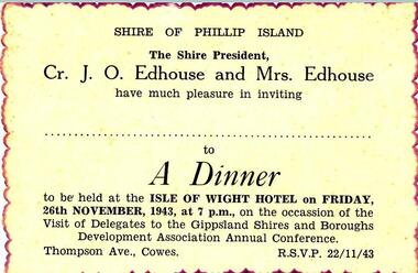
Documents and Photograph donated by the Woodhead family. Dorothy Edhouse was the only child of James & Frances Hill, who were Sylvia Woodhead's grandparents. "James Hill (Jimmy) came to Phillip Island in 1920 and purchased the Hotel, known as Woods Family Hotel. (Later, the Phillip Island Hotel in Walpole Street, now demolished). A milestone occurred whilst in his capable hands, when he installed an electric light plant, (32 volt), the first on the Island. He also made hundreds of cement bricks, when he built his own home. Later he purchased a building in Thompson Avenue, where he established a Billiard Saloon, with a small shop attached. He died in 1937, aged 68. His only child Dorothy Edhouse, is now 95 and has made arrangements to have her ashes added to her fathers' grave." This was added to the photograph of James Hill and Frances Edith Hill - not sure what date it was compiled by Richard Woodhead. Frances died in 1960. The write up was take from "Garden of Memories" by Edith Jeffrey. Four documents/photograph relating to Cr J O Edhouse and his wife Mrs Dorothy Edhouse. Also came with accompanying letter from Sylvia Woodhead. 361-01: An Invitation to a Dinner at the Isle of Wight Hotel - 26/11/1943 - on the occassion of the visit of Delegates to the Gippsland Shires and Boroughs Development Association Annual Conference. 361-03: Identity Card for Dorothy Symes Edhouse. 361-04: Circular from the Liquid Fuel Control Board dated 21st February 1942. 361-05: Photograph of James & Frances Edith Hill. A note saying that James (fondly called Jimmy) came to Phillip Island in 1920 and purchased a hotel - see history below. james & frances edith hill, shire of phillip island dinner invitation, identity card, cr j o edhouse, mrs edhouse, sylvia woodhead, documents -
 Phillip Island and District Historical Society Inc.
Photograph, John Cook, 1978 - 79
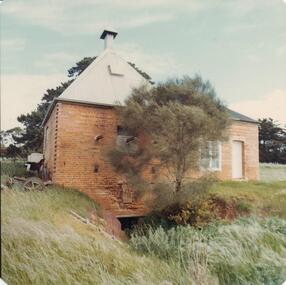
Old Chicory Kiln on Richardsons' Hill, Ventnor Beach Road, Ventor. Now used as a family home. The shed converted into extension of modern house.Brick Chicory Kiln with corrigated iron roof. Note the excavation beneath it for collecting the ashes.coloured photograph, chicory kiln, richardsons hill, john cook, ventnor, phillip island -
 Phillip Island and District Historical Society Inc.
Photograph Album, Kodak, Phillip Island Cemetery, c 1990
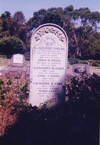
The Album was compiled by Nancy McHaffie late 1990's, with the assistance of Edith Jeffery's, with her book "Garden of Memories" and extensive knowledge of Phillip Island. The Cemetery lies back from the road and is surrounded by Manna Gums, rare Peppermint Gums, Blackwoods and other native trees. In all 25 acres of land were set aside as Crown Land in the land settlement of 1868. There are 6.2 acres of wetlands near the cemetery entrance.466-38: Rev Alexander Robb, DD. Rev Robb had been a missionary in Old Calabar and Jamaica and was the first minister of the Cowes Presbyterian Church from 1890-1901. Services were also held in the Public Hall at Rhyll. A daughter, Kathleen, like her parents, is buried in the cemetery. Kathleen was married to Harry West. 466-39: James Hill. Jimmy, as he was fondly called, came to Phillip Island in 1920 and purchased the Hotel, known as Woods Family Hotel (later the Phillip Island Hotel in Walpole Street). A milestone occurred whilst in his capable hands he installed an electric light plant, (32 volts), the first on the Island. He also made hundreds of cement bricks with which he built his own home. He died in 1937 aged 68. His only child Dorothy Edhouse aged 98, is also buried with her father.phillip island cemetery, james hill, rev alexander robb, nancy mchaffie, edith jeffery -
 Phillip Island and District Historical Society Inc.
Photograph, 1927
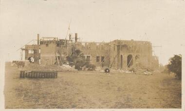
A photo in sepia of the progress of the building of St Pauls Home. There is a builder standing on the top storey and a horse in the foreground.Photograph of construction of the 2 storey brick building. Horse in foreground which would have been used to haul bricks and timber.local history, photography, photographs, slides, film, st pauls training school, schools, phillip island, sepia photograph, ken pound -
 Phillip Island and District Historical Society Inc.
Photograph, circa 1900
... Section of home frontage, single storey brick building...-island-and-the-bass-coast Section of home frontage, single storey ...Section of home frontage, single storey brick building. Elaborately decorated verandah roofing with lace wrought iron. Corrugated section painted in grey and white stripes. Mosaic style flooring of verandah in front of and to sides of lace curtained windows. Four figures of family, mother seated, son standing with hands on back of chair. Two daughters one standing and one kneeling in front.Partial exterior of family on verandah of home.local history, photography, photographs, slides, film, houses, black & white photograph, miss elms san remo -
 Phillip Island and District Historical Society Inc.
Photograph, Genesta Guesthouse, Cowes, Phillip Island
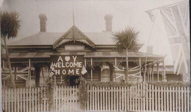
Stanley Kennon originally owned Genesta House. It was sold to the Perry sisters, to Mr & Mrs Odlund, to Mrs Toovey Snr. and then to Mr H Billson who owned the guesthouse in 1935 - 36 when it burned to the ground.Front view close up of Genesta Guesthouse. The building of wood and corrugated iron roofing. Features turret front, two brick chimneys and sporting a Union Jack on flagpole, and Union Jacks draping across the verandah. The sign covering the front door says "Welcome Home". Two palm trees and a hedge are behind a picket fence and gate.local history, photographs, genesta guesthouse, cowes, phillip island, sepia photograph, guesthouses, bruce bennett, betty kuc collection -
 Phillip Island and District Historical Society Inc.
Photograph, 1960's
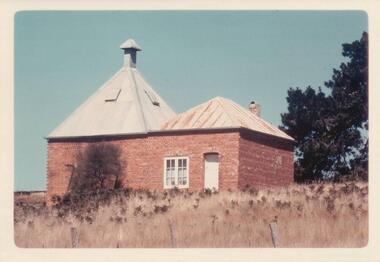
Donated by N. M. & J. D. Archibald, April 1973.Colour Photograph. Ventnor. Hurricane Hill (Richardson's Hill). Built about 1883. 18' x 18'. Brick double one story. Originally built for Mr. T. Richardson. Now being used as a holiday house (1973). Chicory Kiln Album.local history, photography, photographs, agriculture buildings, historic, chicory kiln, hurrican hill, home, richardson, ventnor, n & j archibald, richardson's hill ventnor phillip island -
 Phillip Island and District Historical Society Inc.
Photograph, 1978/79
Rhylstone Park in Thompson Avenue, Cowes, was the home of Mr Vaughan. Later run as a clock museum then a B & B until approx 2007.A brick house built by Mr Joseph Vaughan about 1890. It was named Rhylstone Park. single storey - bull nose verandah.local history, photographs, buildings, historic, buildings - historical, coloured photograph, john cook, phillip island -
 Phillip Island and District Historical Society Inc.
Photograph, 1978 - 79
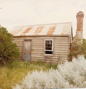
Built by J D McHaffie as a Shepherd's Hut in the 1850 - 60s. At one stage called Julyan's Cottage. Finlay Julyan born there, owned by various families. At one time by H Grayden and R McKinley. Privately owned now. (Noted on the caption that it was built by John Evans about 1870??)Small wooden building on corner of Lyall Street and Ventnor Beach Road. Brick chimney still in situ.local history, photographs, buildings - historic, coloured photograph, john cook, phillip island, settlers home -
 Eltham District Historical Society Inc
Photograph, "Pretty Hill", Kangaroo Ground. James Johnston's homestead
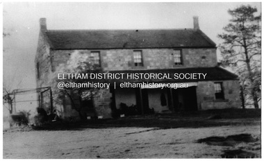
Kangaroo Ground pioneers James Johnston (died 1895) with his wife Elizabeth commenced building this stone house on his Pretty Hill property, Kangaroo Ground in 1842. It was one of the oldest homes in the district till 1938 when new owner Mr Percy Cope, a master builder demolished the old building and a new brick building was erected in its place. Pretty Hill is one of the highest spots in the district with splendid views of the surrounding country.This photo forms part of a collection of photographs gathered by the Shire of Eltham for their centenary project book,"Pioneers and Painters: 100 years of the Shire of Eltham" by Alan Marshall (1971). The collection of over 500 images is held in partnership between Eltham District Historical Society and Yarra Plenty Regional Library (Eltham Library) and is now formally known as 'The Shire of Eltham Pioneers Photograph Collection'. It is significant in being the first community sourced collection representing the places and people of the Shire's first one hundred years.Digital imagesepp, shire of eltham pioneers photograph collection, kangaroo ground, pretty hill, stonen house, homestead, johnston family, james johnston -
 Eltham District Historical Society Inc
Photograph, Monash Bridge, Arthurs Creek Road, Hurstbridge, Eltham Heritage Tour, 24 May 1992, 24/05/1992
ELTHAM HERITAGE TOUR The Society excursion on 24th May 1992 was arranged by David Bick, leader of the team carrying out the Shire's heritage study. David selected a number of sites or buildings identified in the study, some of them lesser known components of the Shire's heritage. The tour commenced at the Eltham Shire Office at 10.00 am. Travel was by private car and mini-bus with stops at about twelve locations for commentary by David.It included a short walk in Hurstbridge and lunch at Kinglake. Highlights of the tour included: - 10 am Leave from Shire Offices - 3 Important Trees - A Physical Link to Eltham's First Settlers - Toorak Mansion Gates - A Surviving Farm House - An Intact Circa 1900 Main Street - First Settlers - Gold Miners, and Timber-getters - An Early Hotel - A Pioneering Homestead - Changing Eltham Shire - 20th Century - 4 pm Afternoon Tea and Finish Tour Extract from ELTHAM CULTURAL HERITAGE TOUR (Newsletter No. 85, July 1992, by Bettina Woodburn) "On the Arthurs Creek Road is a bridge designed by Monash, which we admired before walking across the little park with a mud-brick and timber shelter, to the Hurst family graveyard. There are two marked graves, one, Henry who was shot by Burke the bushranger and a cairn has a plaque listing others buried here from 1866 onwards. Burke was captured and tied to the wheel of a dray under the eucalypt near the waterhose/standpipe. Close by the kindergarten, at this place are three trees on the National Trust Register, a Canary Island pine, a Canadian cedar and probably a spruce. Radiata pines and a thick bolled peppercorn surround the little cemetery. Continuing along Main Street we notice elm trees planted as a war memorial, then on the left a 1930 timber house, a 1910 store and residence, resplendent with wrought iron trim, a double fronted Hardware Store and cypresses on the back alignment of a new vacant block. On the right side of the street is a less interesting attempt at an 'in character' shop. Further on are more early homes, one tucked away at the rear with two tall palms by the front steps. Another curiosity is a rounded veranda corner and there are more galvanised iron sheds or garages, before a mud-brick Dentist's Surgery. Beyond the round-a-about is St Peters Church, of mud-brick construction shared by Catholic and Anglican parishioners, overlooking the river flood plain. Leaving Hurstbridge on the Kinglake Road, we ate our picnic lunch beside the communication tower and enjoyed views of Melbourne, Yan Yean Reservoir and the distant Dandenongs beyond the spreading suburbs. Next we drove to the North West boundary of the Shire at Masons Falls Road towards Whittlesea. On the way to the North East Boundary we passed St Peters, a yellow wooden Church with a Tudor Archway; built in the early 1920's in the style of the 1860's. From the Healesville-Kinglake road the rolling hills had European aspects, the hedged fields and chestnut trees. Then it was back down the Hurstbridge Road through 'Aussie' bush of towering gums, with bracken and scrubby understorey, the Kinglake National Park, before more open country with deciduous trees planted in line, and a creek lined with willows."Record of the Society's history and activities and highlighting various aspects of the Heritage Study undertaken by David Bick used to create the future heritage overlay for the Shire of Eltham and later Nillumbik Shire.Roll of 35mm colour negative film, 4 stripsKodak Gold 100 5095shire of eltham historical society, activities, heritage tour, hurstbridge, monash bridge, arthurs creek road -
 Eltham District Historical Society Inc
Photograph, Stables, Montsalvat
Photograph of stables at Montsalvat, Eltham. Montsalvat is an artist colony, established by Justus Jorgensen in 1934. It is home to over a dozen buildings, houses and halls set amongst richly established gardens on 48,562 m2 (12 acres) of land (Wikpedia). "Many of the buildings (including.. the stable near the animal yard) were designed by Justus Jorgensen in Gothic and/or vernacular styles using mud brick and recycled materials" - Victorian Heritage Database Photo possibly taken by Peter Bassett-Smith. No date. Montsalvat is historically, technically, architecturally, aesthetically, socially and spiritually significant to the State of Victoria.The Montsalvat complex is historically significant because it was established in 1934 by the noted artist and architect Justus Jorgensen. (Victorian Heritage Register)1 photographeltham, montsalvat, stables -
 Eltham District Historical Society Inc
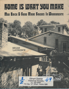
Book, Brian Laurence, Home is what you make : mud brick & hand made houses in Warrandyte / Brian Laurence, 1982c
Paperback; 8 p. : ill. ; 22 cmwarrandyte, houses, mudbrick -
 Eltham District Historical Society Inc
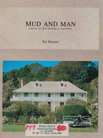
Book, Earthbuild, Mud and Man: a history of earth buildings in Australia by Ted Howard, 1992
Includes references to local sites Bear's Castle, Yan Yean (City of Whitlesea), mud brick houses in Eltham, including at Montsalvat and Eltham Community Centre, Smith's Gully, Plenty Baptist Church and Warrandyte. Includes chapter on Alistair Knox. The author's own home appears in the book on page 100. It was situated at Batman Road, Eltham next to the manse and church opposite Stanley Avenue. It was demolished for unit development June 2004 after the author's death in 2003. A significant and oft cited history of the mud brick earth construction style of architecture which includes a number of examples within the Shire of Nillumbik, known to be a site of the environmental earth building movement following WW2.198 p. : ill. (some col.), maps ISBN 0646069624earth construction, mud bricks, pise, domestic architecture -
 Eltham District Historical Society Inc
Photograph, Peter Bassett-Smith, Heritage Week at 728 Main Road, Eltham, 1990, 1990
Three colour photographs of Heritage Week featuring the brickwork of the former Police Residence and current home of Eltham District Historical Society at 728 Main Road, Eltham. Highlights the use of 'English Bond' on headers and stretchers alternatively and 'Colonial Bond' on one course of headers and three courses of stretchers.heritage week, eltham, courthouse, brick laying, wall, sign, activities -
 Eltham District Historical Society Inc
Photograph, Emergency Operations Centre, S.E.S., Kangaroo Ground
In 2017 known as the Kangaroo Ground Operations Centre a facility for hire managed by the Shire of Nillumbik. On 7 February 2009 (Black Saturday) the CFA Incident Control Centre (ICC) was located here. Described in "Worst of Days: Inside the black Saturday firestorm" by Karen Kissane (access via Google books): "..the ICC is part of a mud brick complex built in the 1980s as an emergency operations centre for several agencies, including the State Emergency Service. It is also home to the headquarters of the CFA's Lower Yarra Group. A small office with a whiteboard would be the incident controller's office throughout the office, but a larger central room, with data projectors, "smart boards" and maps would house the rest of the team.."Statement of Significance From the Victorian Heritage Database (2010) What is significant? The 1988 emergency operations centre and the surrounding site to the title boundaries. How is it significant? The emergency operations centre is architecturally, aesthetically, socially and historically significant to the Shire of Nillumbik. Why is it significant? The emergency operations centre is architecturally and historically significant as a good and rare example of a large public building constructed in a 1980s version of the 'Eltham style', and as a rare attempt to adapt the 'Eltham-style' aesthetic to meet the changing demands of the Shire in the 1980s (Criteria B, D & E). The emergency operations centre is architecturally and aesthetically significant because it is constructed of mud brick and features: a central entry with a tile mural (Criterion E). The emergency operations centre is socially significant because it is a focal point for the community and has played an important role in protecting the community since 1988 (Criterion G).Two colour photographs of mud brick Emergency Operations Centre building, Kangaroo Groundbuildings, mud brick, emergency centre, kangaroo ground -
 Victoria Police Museum
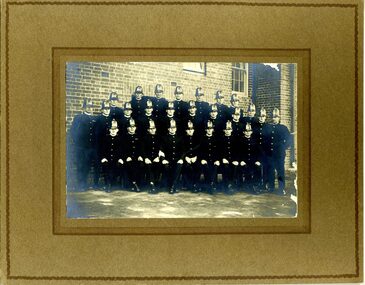
Photograph (Victoria Police Group Photo), Police Officers in group photo, 1920s
Black and white photograph mounted on brown frame. 26 Police Officers in 1920s uniform pose in uniforms with helmets. Set in a terrace with an open brick building with windows on the background. Amongst them is William Arthur Poulter.Handwritten: BILL POULTER 1925 // CENTRE ROW // 5TH FROM LEFT Stamp: PHOTOGRAPH TAKEN // AT YOUR OWN HOME // P. J. DWYER // Onr. Harding & Salisbury Sts. // COBURG // PHOTOGRAPHS COPIED // AND ENLARGEDpoulter, william, william arthur poulter, victoria police museum, dwyer, p. j., police officers -
 Victoria Police Museum
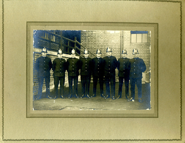
Photograph (Victoria Police Group Photo), Police Officers group in depot, 1920s
Black and white photograph mounted on light brown frame. 8 Police Officers in 1920s uniform pose in uniforms with helmets. Standfing in a terrace with an open brick building with windows and a set of stairs on the background. Amongst them is William Arthur Poulter.Handwritten: BILL POULTER // 3RD FROM RIGHT Handwritten: The M.C.G. Gang // Collingwood - 93 PTS V Melbourne - 43 PTS // 21.8.26 Stamp: PHOTOGRAPH TAKEN // AT YOUR OWN HOME // P. J. DWYER // Onr. Harding & Salisbury Sts. // COBURG // PHOTOGRAPHS COPIED // AND ENLARGEDpoulter, william, william arthur poulter, victoria police museum, dwyer, p. j., police officers -
 Victoria Police Museum
Photograph (Victoria Police Group Photo), Police Officers group in depot, 1920s
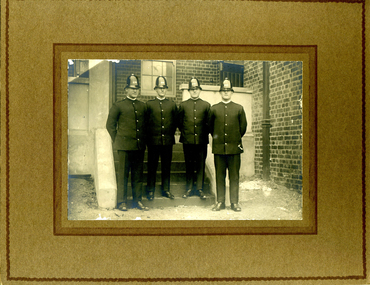
Black and white photograph mounted on light brown frame. 4 Police Officers in 1920s uniform pose in uniforms with helmets. Standfing in a terrace with an open brick house with windows and a set of stairs on the background. On the right is William Arthur Poulter.Handwritten: ON THE RIGHT SIDE // 8060 // W.A. POULTER Stamp: PHOTOGRAPH TAKEN // AT YOUR OWN HOME // P. J. DWYER // Onr. Harding & Salisbury Sts. // COBURG // PHOTOGRAPHS COPIED // AND ENLARGEDpoulter, william, william arthur poulter, victoria police museum, dwyer, p. j., police officers -
 Victoria Police Museum
Photograph (Victoria Police Group Exercise Photo), Police Officers group exercising on depot
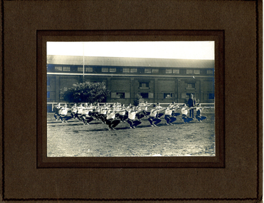
Black and white photograph mounted on light brown frame. Approximately 25 young police officers on physical training with Police Officer in uniform standing and watching. They are all in low squat position, holding sticks straight in front of them - wearing white shirt and dark trousers. Set on earth ground with a tree and big open brick building on the backHandwritten: C 1925 Stamp: PHOTOGRAPH TAKEN // AT YOUR OWN HOME // P. J. DWYER // Onr. Harding & Salisbury Sts. // COBURG // PHOTOGRAPHS COPIED // AND ENLARGEDpoulter, william, william arthur poulter, victoria police museum, dwyer, p. j., police officers, squats, police academy, police training -
Ringwood and District Historical Society
Historical Document, Henrietta C. Walker, A House in the Foothills, 2-Mar-31
Wombolano Park was purchased by Henrietta and Frank Walker, who made many improvements to the house and garden.Article in the Australian Home Beautiful of 2-Mar-1931 about Wombolano homestead and property at Ringwood East. Pages 12,13,14,19,20,21. +Additional Keywords: Walker, Henrietta and Frank Walker"A House in the Foothills" article in The Australian Home Beautiful, 2 March 1931, pp. 12-14 and "Brick-work in the Garden" article in The Australian Home Beautiful, 1 April 1931, pp. 19-21.