Showing 213 items matching " county of bourke"
-
 Bayside Gallery - Bayside City Council Art & Heritage Collection
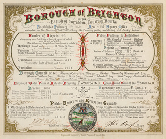
Certificate - Illuminated certificate, Hamel & Fergsuon, Brighton Municipal Certificate, 1866
... county of bourke... councillors council borough county of bourke thomas crisp cr t. crisp ...bayside city council, borough of brighton, illuminated, certificate, population, rates, public buildings, mayor, town clerk, surveyor, councillors, council, borough, county of bourke, thomas crisp, cr t. crisp, census, parish of moorabbin, hamel & ferguson, coat of arms -
 Bayside Gallery - Bayside City Council Art & Heritage Collection
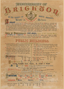
Certificate - Illuminated certificate, Brighton Municipal Certificate, 1861
... county of bourke... population public buildings surveyor council borough county of bourke ...bayside city council, borough of brighton, illuminated, certificate, population, public buildings, surveyor, council, borough, county of bourke, census, colony of victoria -
 Glen Eira Historical Society
Document - Grange Road, 77, Glen Huntly
... Caulfield County of Bourke... Chemists Parish of Prahran Caulfield County of Bourke Building ...This file contains 4 items about the purchase and construction of this property: 1/ The original contract of sale of land dated 25/09/1936 for Gertrude & Hulbert Gorrie situated on the corner of Grange and Neerim Road. 2/ The original typed building agreement dated 25/09/1936 between the contractor Ernest F Barnard and the purchasers Mr & Mrs Hulbert Gorrie. 3/ The original blueprint plan of a brick villa at the corner of Grange & Neerim Road for Mr & Mrs Hulbert Gorrie. Dated 25/09/1936. 4/ The original specification for the dwelling on the corner of Grange & Neerim Road, Glen Huntly for Mrs Gertrude Gorrie & Mr Hulbert Hopetoun Gorrie by builder Ernest F Barnard.barnard ernest f, gorrie gertrude, gorrie hulbert hopetoun, hobart john bertram, coorigil road, carnegie, holloway st, ormond, chemists, parish of prahran, caulfield county of bourke, building agreement, brick houses, builders, plans, architectural drawings, grange road, glen huntly, holloway street, ormond, emma street, grange road, neerim road, gorrie h.h, gorrie gertrude, gorrie hulbert h, legal documents, barnard ernest franklin, e. j. & h. amos, hintons nursery, real estate agents, murrumbeena, caulfield -
Glen Eira Historical Society
Document - Grange Road, 77, Glen Huntly
... Caulfield County of Bourke... Parish of Prahran Caulfield County of Bourke Legal Document ...This file contains one item about the sale and history of the then unnumbered property and the first owners of the home at 77 Grange Road, south west corner with Neerim Road, then in the suburb of Carnegie: 1/ A typed sheet with the details and documents that were given to the society in 1987. These are biographical details provided by the son of Hulbert Gorrie, a Chemist who worked at Rankin and Eyval Chemists shop at 165 Glenhuntly Road (from around 1920 to 1957). Hulbert and his wife Gertrude Gorrie purchased the vacant block and built the first house at the address in 1936. The photo mentioned of Hulbert at the shop is held in our file 1080A Glenhuntly Road Elsternwick. gorrie gertrude, gorrie hulbert hopetoun, barnard ernest franklin, hobart john bertram, grange road, neerim road, elsternwick, contract of sale of land, dwelling, land, e.j & h amos, hintons nursery, real estate agents, builder, glen huntly, coorigil road, murrumbeena, emma st, caulfield, parish of prahran, caulfield county of bourke, legal document, chemist, rankin and eyval shop, glenhuntly road, carnegie, glen huntly road -
 Greensborough Historical Society
Map, Greensborough Map with Rail Line Plan, 1970s
... Parish of Keelbundora, County of Bourke. Central... station Parish of Keelbundora, County of Bourke. Central ...Central Greensborough area, including railway line and some landowners. Basic map made c. 1902; annotations dated to circa 1970sTwo copies of planParish of Keelbundora, County of Bourke. Central Greensborough areagreensborough, greensborough railway station -
Whitehorse Historical Society Inc.
Map, Parish of Nunawading, 1970
... [Parish of] Nunawading, County of Bourke. Government... [Parish of] Nunawading, County of Bourke. Government Printer ...[Parish of] Nunawading, County of Bourke. Government Printer Showing original land owners.parish of nunawading, maps, land settlement -
Whitehorse Historical Society Inc.
Map, Plan, 1939
... , Parish of Nunawading, County of Bourke... portion 83A and 83, Parish of Nunawading, County of Bourke Plan ...Plan of subdivision, part of crown portion 83A and 83, Parish of Nunawading, County of BourkePlan of subdivision, part of crown portion 83A and 83, Parish of Nunawading, County of BourkePlan of subdivision, part of crown portion 83A and 83, Parish of Nunawading, County of Bourkestreet names, parish of nunawading, station street, blackburn, railway road, blackburn, vine street, blackburn, south parade, blackburn, laburnum street, blackburn, main street, blackburn, gardenia street, blackburn, the avenue, blackburn, fuschia street, blackburn, linum street, blackburn -
 Ringwood and District Historical Society
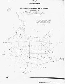
Photograph, Map-Country Lands, in the parishes of Nunawading, Ringwood and Scoresby (undated)
... , in the parishes of Nunawading, Ringwood and Scoresby, in the counties... and Scoresby, in the counties of Bourke and Mornington". Map-Country ...Early (undated) photograph of plan of "Country Lands, in the parishes of Nunawading, Ringwood and Scoresby, in the counties of Bourke and Mornington". -
 Whitehorse Historical Society Inc.
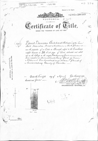
Document, Crown Allotment
... Nunawading Parish of Nunawading County of Bourke... of Nunawading County of Bourke Land documents relating to Crown ...Land documents relating to Crown Allotment 116 Shady Grove Nunawading Parish of Nunawading County of BourkeLand documents relating to Crown Allotment 116 Shady Grove Nunawading Parish of Nunawading County of BourkeLand documents relating to Crown Allotment 116 Shady Grove Nunawading Parish of Nunawading County of Bourkeland titles, holmes, dave, shady grove nunawading no.76, helen, jobbins, thomas, the freehold investment and banking company of australia ltd, wilson, david duncan butchart, boyle, walter, holbery, emily rachel, fisher, james cowley morgan -
 City of Moorabbin Historical Society (Operating the Box Cottage Museum)
Photograph - Map of Dendy's Special Survey, 1852 Map of Henry Dendy's Special Survey of 1841, 19th Century
... Moorabbin County of Bourke / Photo-Lithographed... bent thomas were jonathan special survey Moorabbin County ...A Map drawn in 1852 that shows the 5,120 acres that formed Dendy's Special Survey of 1841. In 1840 Henry Dendy, a farmer in Surrey, England acquired a "Special Survey" from the Commissioners for Land and Emigration which gave Dendy the right to choose land in Port Phillip for the "bargain basement" price of only £1 per acre for 5120 acres, (an area of 8 square miles). The Special Survey also included the right to "the shipment of a worker for every £20 spent on land, whose free passage was paid by the Crown, equalling a total of 100 workers ". Accordingly Dendy sold his English holdings and paid the required £5120 and arrived in Melbourne in February 1841. However by this time land in the new colony was selling for £5 - £40 per acre. Because Henry Dendy possessed the order from the Colonial Office in London he was able to successfully oppose Governor LaTrobe's attempts to alter the price of the land. Dendy appointed Jonathan Were, (an entrepreneur, who had arrived in 1839), as his Manager and who later became a partner. Together, Dendy and Were decided on an area 5 miles south from Melbourne, bounded by North Road, East Boundary Road, South Road and to the west by Port Phillip Bay. Were and Dendy pitched their tents in the area now known as ' Park St, Brighton' and sank a well near the corner of 'St Andrew's St and Wells St'. By 1845 J.B Were and Company had bought almost half of Dendy's land and Were built himself "Moorabbin House" in Were St Brighton made from stone, quarried from local cliffs. It was still standing in 1924. Legend records Moorabbin is named after the Aboriginal word for ' Mother's Milk ' The soil is very fertile and well supplied with water especially in the area called 'East Brighton' - now known as Bentleigh and East Bentleigh - By 1850 the area had developed with numerous market gardens, dairy farms, fruit gardens and vineyards supplying food for the growing population of Melbourne.This Map shows the birth of the Brighton and Moorabbin area. On 18th January1859 Brighton was proclaimed a Municipality and a Borough by October 1863. Meanwhile, following a Petition, the area of East and South Brighton, incorporating Mordialloc, Cheltenham, Mentone, Sandringham and Oakleigh separated from Brighton to form the Moorabbin District Roads Board becoming the first Local Government Authority. Col. William Mair was elected as the first Chairman of the Moorabbin Roads Board. Moorabbin Shire 1871 developed further and was declared a City in1934. The City of Moorabbin was the largest Municipality in Melbourne before the Amalgamation of Councils in 1994 when it was divided in the south to City of Kingston and in the north to City of Glen Eira A Photo-lithographed 1852 Map showing the 5,120 acres that formed Dendy's Special Survey of 1841. Henry Dendy & Jonathan Were chose an area 5 miles south from Melbourne, bounded by North Road, East Boundary Road, South Road and to the west by Port Phillip Bay. Moorabbin County of Bourke / Photo-Lithographed at the department of Lands and Survey. /Melbourne. / Price 1/- brighton, moorabbin, bentleigh, cheltenham, dendy henry, bent thomas, were jonathan, special survey -
![Parish of Nunawading, County of Bourke showing land acquired under Closer Settlement Acts [C 1887]](/media/collectors/56f368632162f118acbff12e/items/60d923316e5f99545134f182/item-media/6147b12a4806c7ae686c24e4/item-fit-380x285.jpg) Whitehorse Historical Society Inc.
Whitehorse Historical Society Inc.Map, Parish of Nunawading, ca 1887
... Parish of Nunawading, County of Bourke showing land... settlement Parish of Nunawading, County of Bourke showing land ...Parish of Nunawading, County of Bourke showing land acquired under Closer Settlement Acts [C 1887]Parish of Nunawading, County of Bourke showing land acquired under Closer Settlement Acts [C 1887] 1947 reprint.Parish of Nunawading, County of Bourke showing land acquired under Closer Settlement Acts [C 1887] parish of nunawading, box hill, maps, land settlement -
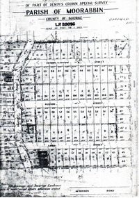 City of Moorabbin Historical Society (Operating the Box Cottage Museum)
Flyer - Garfield Estate, Ormond
... - County of Bourke - Garfield Estate... - parish of Moorabbin - County of Bourke - Garfield Estate ...At the end of World War One, there was a renewed interest in residential land and a number of estates opened up in the Municipality of Moorabbin.Example of the progress of the Municipality of MoorabbinPhotocopy of the plan of the Garfield Estate, OrmondPart f Dendy's Crown Special Survey - parish of Moorabbin - County of Bourke - Garfield Estatedraper street, lord street, hudson street, blackshaw street, tucker road, ormond, mckinnon, real estate -
Whitehorse Historical Society Inc.
Legal record - Land Title, Blackburn
... , Parish of Nunawading, County of Bourke. Photograph produced 11..., County of Bourke. Photograph produced 11 Aug 1947. Plan ...Plan of subdivision of part of Crown Portions 81,92 and 89, Parish of Nunawading, County of Bourke. Photograph produced 11 Aug 1947.Plan of subdivision of part of Crown Portions 81,92 and 89, Parish of Nunawading, County of Bourke. Photograph produced 11 Aug 1947.Plan of subdivision of part of Crown Portions 81,92 and 89, Parish of Nunawading, County of Bourke. Photograph produced 11 Aug 1947.blackburn road, blackburn, wellington avenue, central road, gordon crescent, wolseley crescent -
Port Melbourne Historical & Preservation Society
Plan - Port Melbourne, 1882
... of South Melbourne, County of Bourke - showing Town Lots. Pasted... Melbourne, County of Bourke - showing Town Lots. Pasted onto board ...Large, deteriorated 1882 plan of Port Melbourne, Parish of South Melbourne, County of Bourke - showing Town Lots. Pasted onto board.town planning, fishermans bend, sandridge lagoon, transport - railways -
Whitehorse Historical Society Inc.
Map, Survey for road from Doncaster to Ringwood, 01/03/1867
... Survey in County of Bourke, Road Plan no. 390, showing... in County of Bourke, Road Plan no. 390, showing early routes ...Survey in County of Bourke, Road Plan no. 390, showing early routes of Doncaster, Whitehorse and Mitcham Roads.Survey in County of Bourke, Road Plan no. 390, showing early routes of Doncaster, Whitehorse and Mitcham Roads. Measurement in chains. Surveyor: Thomas E. Rawlinson.Survey in County of Bourke, Road Plan no. 390, showing early routes of Doncaster, Whitehorse and Mitcham Roads. parish of nunawading, parish of bulleen, whitehorse road mitcham, doncaster road, doncaster east, mitcham road mitcham -
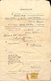 Whitehorse Historical Society Inc.
Document, Mitcham, 1/03/1915
... , Parish of Nunawading, County of Bourke being Lot 6 on plan... of Nunawading, County of Bourke being Lot 6 on plan of subdivision ...Contract of sale of part Crown Portion 119,05 Mitcham, Parish of Nunawading, County of Bourke being Lot 6 on plan of subdivision No. 5339, by Thomas Keogh to Jessie Wathenland sales, wathen, jessie, keogh, thomas, mitcham -
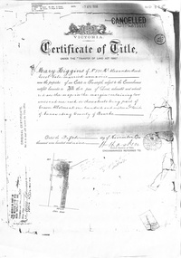 Whitehorse Historical Society Inc.
Certificate - Land Title document, Crown Allotment, 5/11/1909
... No. 116 Parish of Nunawading County of Bourke.... Land Allotment No. 116 Parish of Nunawading County of Bourke ...Certificate of Title dated 5/11/1909 covering land in Shady Grove Nunawading purchased by Mary Higgins. Crown Land Allotment No. 116 Parish of Nunawading County of Bourke.land titles, higgins, mary, holmes, dave, shady grove nunawading no.76, helen -
Whitehorse Historical Society Inc.
Map, Nunawading, Ringwood and Scoresby, 16/02/1858 (original)
... , Ringwood and Scoresby in the Counties of Bourke and Mornington... in the Counties of Bourke and Mornington. Lithographed at the Public Lands ...Plan of country lands in the Parishes of Nunawading, Ringwood and Scoresby in the Counties of Bourke and Mornington. Lithographed at the Public Lands Office, Melbourne, 16 February 1858. Inset: Pound Reserve, Nunawading.nunawading, ringwood, scoresby, maps -
Whitehorse Historical Society Inc.
Document, What happened to Norwich?
... of Nunawading, County of Bourke, found on a land sale map in the La..., consisting of 475 acres in the Parish of Nunawading, County of Bourke ...Norwich, consisting of 475 acres in the Parish of Nunawading, County of Bourke, found on a land sale map in the La Trobe collection of Vale maps.Norwich, consisting of 475 acres in the Parish of Nunawading, County of Bourke, found on a land sale map in the La Trobe collection of Vale maps. Research by Jean Uhl into the fate of the proposed township.Norwich, consisting of 475 acres in the Parish of Nunawading, County of Bourke, found on a land sale map in the La Trobe collection of Vale maps. local history, uhl, jean, parish of nunawading, norwich village, vermont, lobb, john, graham, thomas -
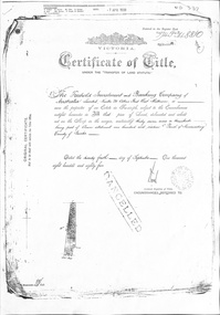 Whitehorse Historical Society Inc.
Certificate - Land Title Document, Crown Allotment, 24/9/1885
... County of Bourke... of Nunawading County of Bourke Crown Allotment Certificate Land Title ...Certificate of Title dated 4/9/1885 covering land in Shady Grove Nunawading purchased by The Freehold Investment and Banking Company. Crown Allotment No. 116 Parish of Nunawading County of Bourkeland titles, shady grove nunawading no. 76, crown land allotment no. 116, the freehold investment and banking company of australia ltd., higgins, mary, holmes, dave, wilson, david duncan butchart, helen -
 Greensborough Historical Society
Map, Victoria. Department of Crown Lands and Survey, Keelbundoora; Counties of Bourke and Evelyn, 1950c
... Map of the Victorian counties of Bourke and Evelyn showing...; Counties of Bourke and Evelyn Map Victoria. Department of Crown ...Map of the Victorian counties of Bourke and Evelyn showing parish boundaries and land ownership.Show the original landholders for this area.Map on light brown parchment, covered in plastic."L.5305" and "3462" -
 Whitehorse Historical Society Inc.
Certificate - Certificate of Title, Crown Allotment, 12/04/1904
... . Crown Land Allotment No. 116 Parish of Nunawading County... County of Bourke Crown Allotment Certificate Certificate of Title ...Certificate of Title dated 12/4/1904 covering land in Shady Grove, Nunawading purchased by David Duncan Butchart Wilson. Crown Land Allotment No. 116 Parish of Nunawading County of Bourkeland titles, wilson, david duncan butchart, shady grove nunawading no. 76, higgins, mary, alcock, horace, holmes, dave, thumberstone, henry, helen -
Hume City Civic Collection
Map, Sunbury Township 1857
... in the County of Bourke produced by the Public Records Office... in the County of Bourke produced by the Public Records Office ...This is a reprint of a 1857 map of the township of Sunbury in the County of Bourke produced by the Public Records Office by courtesy of the Surveyor General in 1978.This is a reprint of a 1857 map of the township of Sunbury.sunbury, shire of bulla, sunbury township, 1850s -
 Ringwood and District Historical Society
Map, Subdivision Plan - 8 residential allotments south of City Road on Wantirna Road, Ringwood, Victoria - (Undated - circa 1950s)
... Part of Crown Portion 11, Parish of Ringwood, County...Part of Crown Portion 11, Parish of Ringwood, County ...Hand-drawn map on cardboard backing.Part of Crown Portion 11, Parish of Ringwood, County of Bourke. Some allotments include real estate sales notations. (North arrow incorrectly points east.) -
Whitehorse Historical Society Inc.
Document, Certificate of Title, 1913 - 1933
... Parish of Nunawading County of Bourke. Vol 3698 Fol 739579 June... of Nunawading County of Bourke. Certificate of Title, Mary Elizabeth ...Certificate of Title, Mary Elizabeth Allen of Blackburn Road, Blackburn for land, part of Crown Portion 89 at Blackburn Parish of Nunawading County of Bourke.Certificate of Title, Mary Elizabeth Allen of Blackburn Road, Blackburn for land, part of Crown Portion 89 at Blackburn Parish of Nunawading County of Bourke. Vol 3698 Fol 739579 June 19143 also correspondence on rates, 1933.Certificate of Title, Mary Elizabeth Allen of Blackburn Road, Blackburn for land, part of Crown Portion 89 at Blackburn Parish of Nunawading County of Bourke. land titles, shire of nunawading, shire of blackburn and mitcham, allen, mary elizabeth, blackburn road, blackburn -
 Bacchus Marsh & District Historical Society
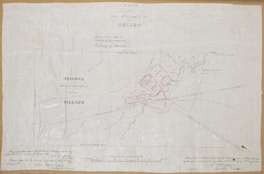
Map, Plan of the Village of Melton
... of Melton, Parish of Djerriwarrh, County of Bourke. The map... for the village of Melton, Parish of Djerriwarrh, County of Bourke ...A single page paper map showing a plan for the village of Melton, Parish of Djerriwarrh, County of Bourke. The map is pasted into a bound volume containing 76 maps or plans in total. High resolution digital image stored on BMDHS computer network. melton victoria maps -
 Greensborough Historical Society
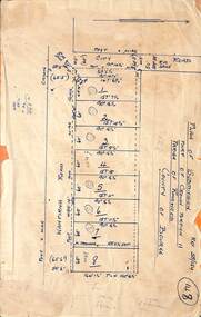
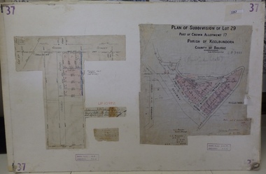
Planning Document, Subdivision Plan # 37. Poulter Avenue and Bicton Street; and, Adeline Street and Grimshaw Street Greensborough, 1971_
... of Keelbundoora, County of Bourke. Poulter Avenue and Bicton Street... of Crown Allotment, Parish of Keelbundoora, County of Bourke ...Plan of subdivision Lot 29, Part of Crown Allotment, Parish of Keelbundoora, County of Bourke. Poulter Avenue and Bicton Street; and, Adeline Street and Grimshaw Street.An example of hard copy subdivision plans from the Greensborough area. Mainly from the Shire of Diamond Valley era (1964-1994).Plan (2 sheets) mounted on heavy card. subdivision plans, grimshaw street, poulter avenue, adeline street -
Whitehorse Historical Society Inc.
Map, Township of Norwich, ca 1850
... of Section III, Parish of Nunawading, County of Bourke, consisting... subdivision of Section III, Parish of Nunawading, County of Bourke ...Plan of the Township of Norwich being subdivision of Section III, Parish of Nunawading, County of Bourke, consisting of suburban farms, vineyard sites and town lots, for sale by auction by W. Casey & Co. [c. 1850]. Original in Vale Maps Collection, La Trobe Library.norwich village, vermont, parish of nunawading, vermont south, maps -
 Bacchus Marsh & District Historical Society
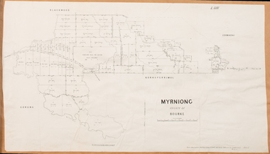
Map, Myrniong Parish Map 1904
... of Myrniong in the County of Bourke. A cadastral map showing parish... for the Parish of Myrniong in the County of Bourke. A cadastral map ...A single page paper map showing the map for the Parish of Myrniong in the County of Bourke. A cadastral map showing parish boundaries and land ownership. The map is pasted into a bound volume containing 76 maps or plans in total. High resolution digital image stored on BMDHS computer network. myrniong parish plan, myrniong parish maps, bacchus marsh region parish plans -
 Bacchus Marsh & District Historical Society
Map, Plan of Survey of Part of Crown Allotment 9, Parish of Korkuperrimul, 1890
... of Korkuperrimul, County of Bourke. Scale 100 feet to inch. Part of a set..., Parish of Korkuperrimul, County of Bourke. Scale 100 feet to inch ...This map documents a transfer of an allotment of land in Clarke Street Bacchus Marsh in 1890. Clarke Street is located on the eastern side of Bacchus Marsh not far from Main Street and Crook Street. It is now known as Candeloro Street. The map indicates J. Booth as the owner of the land and H. Simpson as the occupier. Next to this allotment is a an allotment of land owned by J. Elmore,Single page map showing Crown allotment 9, Parish of Korkuperrimul, County of Bourke. Scale 100 feet to inch. Part of a set of maps which are pasted into a bound volume containing 76 maps or plans in total. High resolution digital image stored on BMDHS computer network. At bottom of map: I hereby certify that I have made this survey expressly for the purpose of an application under the Transfer of Land Statute that this plan is correct. Barry B???, Lic. Surveyor, 16.10.90bacchus marsh victoria maps, clarke street bacchus marsh maps