Showing 629 items matching " financial documents"
-
 Bendigo Historical Society Inc.
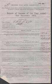
Document - COHN BROTHERS COLLECTION: OFFICIAL RETURN YEAR ENDED 31ST DECEMBER 1904
... notes and figures pertaining to that financial year. Document ...[a] Printed Official Return of the Year Ended 31st December 1904 under Income Tax Schedule C,Name of Company used Initials C,B,V, B,C Ltd. [b] Included both sides on printed Cohns Victoria Brewery notepaper a list of handwritten notes and figures pertaining to that financial year.bendigo, industry, cohn bros brewery -
 Bendigo Historical Society Inc.
Financial record - COHN BROTHERS COLLECTION: 1894 INSOLVENCY DOCUMENT - STATEMENT OF LOSSES
... DOCUMENT Financial Statements Insolvency Part a,b,c, relate ...Part a,b,c, relate to insolvency documents of Robert Neave. Part a, Notice To Creditors Of General Meeting under the Insolvency Act of 1890 sent to creditors by Messrs Braham and Pirana of Trustees Chambers No 412 Collins Street Melbourne. Cohn Bros Victoria Brewery named as creditors./ part c - Statement of losses in the estate of Robert Neave to January 1894document, financial statements, insolvency -
 Bendigo Historical Society Inc.
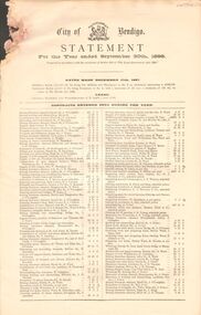
Document - CITY OF BENDIGO STATEMENTS
Four financial statements from the city of Bendigo for the years ending September 30th in 1898, 1901, 1902, and 1908. These show the rates made for that year, the contracts entered into during the year and also statements of receipts and expenditure for that yearbendigo, council, financial statements, city of bendigo, rates , contracts, 1898 1901 1902 1908 -
 Bendigo Historical Society Inc.
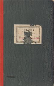
Document - BENDIGO BOYS TRAINING FARM LEDGER
Dark green covers, red spine. Ledger book of financial records of Boys' Training Farm 1935 - 1937. Payments to Bendigo businesses listed and financial costs of running aspects of the farm detailed. e.g. Wages - lads; piggery, fowl pens, implement shed, windmill ( pages 46 - 50)bendigo, institutions, boys' training farm, boys' training farm, j.t. keane, flora hill -
 Bendigo Historical Society Inc.
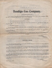
Document - AGENDA FOR MEETING - BENDIGO GAS COMPANY, 1921
Agenda for Meeting and Order of Meeting - Bendigo Gas Company. Half-yearly Ordinary Meeting of Shareholders. 24/2/1921. Business items; Director's Report; Financial Statements. H Johns, Sec. J B Young, Chairman.organization, business, bendigo gas company -
 Bendigo Historical Society Inc.
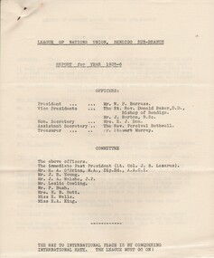
Document - CURNOW COLLECTION: ANNUAL REPORT LEAGUE OF NATIONS UNION, 1936
ANNUAL REPORT - LEAGUE OF NATIONS UNION, BENDIGO SUB-BRANCH. 6 page foolscap report document Annual Report 1935 -36 prepared by M Don (Hon Sec). List of Office Bearers & Committee on front page; list of meeting speakers on Page 1. Financial Statement audited by H N Butt. Prepared by Stewart Murray (Hon Treasurer).person, individual, curnow collection -
 Bendigo Historical Society Inc.
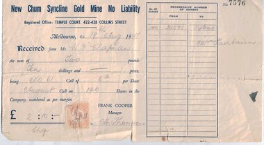
Financial record - Mining documents, 1940-47
... Mine, and also to confirm a change of address. Financial record ...The New Chum Syncline Mine was in Happy Valley Road, West BendigoRobinson Fairbairn Collection: New Chum Syncline Gold Mine Shares - 18 in total - all representing 100 shares signed by the Manager Frank Cooper, one of these has a duty stamp attached. New Chum Syncline Gold Mine Forfeiture Notice - for nonpayment of the June Calls in the Golden Sovereign Mine and the New Chum Syncline Gold Mine New Chum Syncline Gold Mine Letter to Shareholder Mrs. S.M. Hosking, acknowledgement of payment for the No 88 Call in the New Chum Syncline Mine, and also to confirm a change of address.history, mining, robinson fairbairn collection, shares, bendigo, new chum syncline mine, golden sovereign mine -
 Bendigo Historical Society Inc.
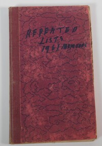
Document - COMBINED PENSIONERS' ASSOCIATION: MEMBERS REGISTER 1961, 1961-1962
Combined Pensioners' Association Members Register 1961 - 1962 contained in red patterned index book. Handwritten 'The Combined Pensioner Assoc. Bendigo Branch' on inside front cover. Financial members Combined Pensioners Assoc, are listed for 1961 and 1962 and arranged according to surname and including address. -
 Bendigo Historical Society Inc.
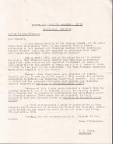
Document - HANRO COLLECTION: AUSTRALIAN TEXTILE WORKERS' UNION LETTER
Type written letter from L.A. Chung, Secretary of the Australian Textile Workers' Union Provincial Division to Shop Stewards requesting to provide the number of financial members employed on a rotating or permanent night shifts.hanro, clothing, stationary -
 Bendigo Historical Society Inc.
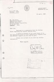
Document - KANGAROO FLAT GOLD MINE COLLECTION: SUBMISSION TO WESTERN MINING CORPORATION BY CENTRAL DEBORAH GOLD MINE
Letter from Daryl McClure, M.L.A.Member for Bendigo, 24th April, 1980, to Jim Lalor, Exploration Manager, Eastern Division, Western Mining Corporation, Preston. Attached is six page submission titled 'The Bendigo Trust, Central Deborah Gold Mine, submission to Western Mining Corporation 'to request financial assistance for the further development of the Central Deborah Gold Mine'.bendigo, gold mining, central deborah gold mineg, central deborah gold mine, western mining corporation, jim lalor, daryl mcclure. -
 Bendigo Historical Society Inc.
Document - G. ALICE JONES COLLECTION: ESTATE OF ANNIE ELIZABETH JONES
Three pages of handwritten records relating to the estate of Annie Elizabeth Jones. The records are from the financial year 1949/50 and are list of assets and receipts of income.person, individual, g.alice jones -
 Bendigo Historical Society Inc.
Document - JOHN EVANS COLLECTION: CYANIDE AND FINANCIAL RECORDS FOR MARCH 1902 TO JAN 1905
CYANIDE RECORDS AND FINANCIAL RECORDS (PETTY CASH) FOR MARCH 1902 - END 1904/JAN1905, Listed a #13. Various names entered on to inside covers include Edward Lindup; Mr A H Thomas; Simon Chalarn (re loan)bendigo, industry, sebastian cyanide works -
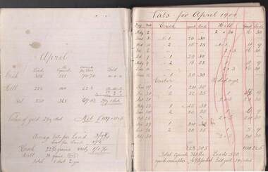 Bendigo Historical Society Inc.
Document - JOHN EVANS COLLECTION: CYANIDE OPERATION RECORDS: APRIL 1900 TO MARCH 1901
Cyanide Operation Records (April 1900-March 1901; Statements/Petty Cash April 1900 -March 1901. Listed as #10 - only as Cyanide operation records. Cyanide operation records are headed on each page as ‘‘Vats for (month (year)''. Operation Records and financial statements are entered separately from the front and back of the book. In centre, between these entries are some torn out pages plus handwritten copy of a draft?? Letter to The Hon the Minister of Mines re some miners' ''unfortunate situation'' - requesting an interview in relation to the matter concerning a mining lease issue and trespass. No name is attached as a signature to indicate the author of said letter.bendigo, industry, sebastian cyanide works, cyanide operation records -
 Bendigo Historical Society Inc.
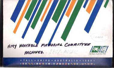
Document - AMY HUXTABLE COLLECTION: COMMITTEE ARCHIVES, 1st April, 1980
''Amy Huxtable Memorial Committee Archives''. Folder comprising approximately 80 items - informative and valuable detailed correspondence,short articles, newspaper items and general background to the various memorial projects designed to commemorate the life of Amy Huxtable. This archive covers the period from 1980 to 1993 when the various projects - a Garden Seat, microfilming of the raft of Huxtable newspaper articles, (Ola Cohn Fountain restoration - not proceeded with), purchase of three Ola Cohn sculptures for Bendigo Art Gallery - were under discussion and action. Financial information included with interesting correspondence and material giving details of life and work of Amy Huxtable.person, individual, amy huxtable, bendigo advertiser, ola cohn, bendigo art gallery, cox business college, view street, bendigo home and hospital for the aged, bendigo and northern district base hospital, mirridong home for the blind, cr. r.l. campbell. -
 Bendigo Historical Society Inc.
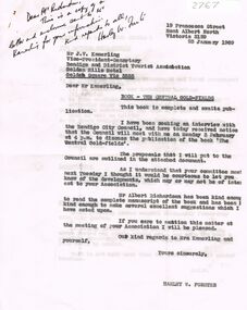
Document - CORRESPONDENCE FROM H FORSTER: PUBLISH BOOK
Correspondence from Harley W Forster re Book to be published - 'The Central Goldfields'. And request for financial support in publishing it. January 1969.person, individual, harley w forester, the central gold fields. -
 Bendigo Historical Society Inc.
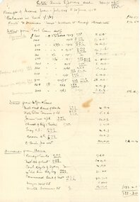
Document - MCCOLL, RANKIN AND STANISTREET COLLECTION: GOLDEN CARSHALTON, 1946/51
Manilla folder containing financial statements. Assets for realization, Directors Reports, Purchase Whippet Consolidated Shares, Report Geo. A. Pell, Report J.J.Stanistreet - re Company finances.MCCOLL RANKIN & STANISTREETorganization, business, gold mine accounting., mccoll rankin & stanistreet -
 Bendigo Historical Society Inc.
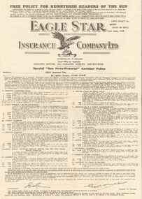
Document - GERTRUDE PERRY COLLECTION: EAGLE STAR INSURANCE COMPANY POLICY, 1952
Document. Eagle Star Insurance Company Policy. Eagle Star Insurance Company Free Policy Document issued to readers of The Sun News Pictorial. Policy No. 440539 Issued 21st June 1952 in the name of Perry Gertrude Eva, 38 Panton Street, Golden Square.organization, business, financial, gertrude perry collection, eagle star insurance company policy, perry gertrude eva, the sun news pictorial -
 Bendigo Historical Society Inc.
Document - MCCOLL, RANKIN AND STANISTREET COLLECTION: EAST CLARENCE GOLD MINING CO. FINANCIAL, 1946/50
... document; Cardboard folder contains financial statements... financial statements. East Clarence financial statements. Document ...document; Cardboard folder contains financial statements. East Clarence financial statements.MCCOLL RANKIN & STANISTREETorganization, business, gold mine accounting., mccoll rankin & stanistreet -
 Bendigo Historical Society Inc.
Document - ANCIENT ORDER OF FORESTERS NO. 3770 COLLECTION: CORRESPONDENCE
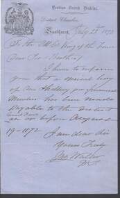
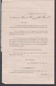
Note written on blue, watermarked paper and dated July 22nd 1872. 'I have to inform you that a special levy of One Shilling per financial Member has been made payable to the District General Fund on or before August 19 -1872.' Signed ? Wall?, D.C. Bendigo United District A.O.F. impression stamp in the bottom corner.societies, aof, correspondence, ancient order of foresters no. 3770 collection - correspondence, bendigo united district, court king of the forest, wall? -
 Bendigo Historical Society Inc.
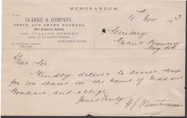
Document - COHN BROTHERS COLLECTION: 1893 LETTER
Memorandum of Clarke & Company, Stock and Share Brokers and Financial Agents, 309 Collins Street Melbourne to Secretary Cohns Brewery dated 18th November 1893. Signed H F Moucheau. Kindly deliver scrip for 200 shares in the name of Madame Bouteau.bendigo, industry, cohn bros brewery -
 Bendigo Historical Society Inc.
Document - ANCIENT ORDER OF FORESTERS NO. 3770 COLLECTION: CORRESPONDENCE
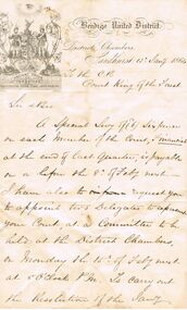
Letter, dated 25 April 1964, mentioning that a Special Levy of sixpence on every financial member returned by the Court, at the end of last quarter, is payable on or before the 8 May . Signed James Madeley. Written on paper with printed letterhead and emblem.societies, aof, correspondence, ancient order of foresters no. 3770 collection - correspondence, bendigo united district, court king of the forest, james madeley -
 Bendigo Historical Society Inc.
Document - ANCIENT ORDER OF FORESTERS NO. 3770 COLLECTION: CORRESPONDENCE
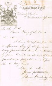
Letter from James Madely,dated 13th Jany 1864 mentioning that a Special Levy of 6 pence on each Member of the Court, Financial at the end of last quarter, was payable on r before the 8th Feby next. He also requests the appointment of two Delegates to represent the Court, at a Committee to be held on 15th Feby. Preparations for the Celebration of the Anniversary of the District.societies, aof, correspondence, ancient order of foresters no. 3770 collection - correspondence, bendigo united district, cou;rt king of the forest, james madely -
 Bendigo Historical Society Inc.
Document - ANCIENT ORDER OF FORESTERS NO. 3770 COLLECTION: CORRESPONDENCE
Printed circular from J A NIEMANN G M Hon Sec to the Members of Court King of the Forest dated 11.1.1872 . A resolution was passed at a financial meeting of the Loyal Heart of Friendship and the Deutscher Verein that a committee of three be appointed, to confer with other Lodges and kindred Societies, for the purpose of establishing a Friendly Societies' Mediacal Dispensary.societies, aof, correspondence, ancient order of foresters no. 3770 collection - correspondence, court king of the forest, loyal heart of friendship lodge, deutscher verein, old fellows' hall, j a niemann -
 Bendigo Historical Society Inc.
Document - LYDIA CHANCELLOR COLLECTION: AUSTRALIAN COMFORTS FUND REPORT
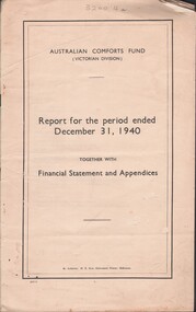
(i) Report for the period ended December 31, 1940. Together with Financial Statement and Appendices. Australian Comforts Fund (Victorian Division). By Authority : H.E. Daw, Government Printer, Melbourne. 24 pgs.(ii) Second Annual Report. Together with Financial Statement and Appendices for the Year ended December 31, 1941. Australian Comforts Fund (Victorian Division). By Authority: H.E. Daw, Government Printer, Melbourne.organization, club / society, australian comforts fund, lydia chancellor, collection, australian comforts fund, war, world war 11 -
 Bendigo Historical Society Inc.
Document - ANCIENT ORDER OF FORESTERS NO. 3770 COLLECTION: CORRESPONDENCE
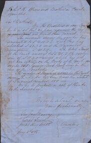
Auditors report written on blue paper and dated June 29th 1863. Auditors were satisfied with the way the books were kept and found they were correct. They also report on the financial position and do not think it necessary to have a Special Levy yet. Signed by the Auditors Joseph King Smith, Hugh Brown and G I Murray.societies, aof, correspondence, ancient order of foresters no. 3770 collection - correspondence, court king of the forest, savings bank, bro holl, joseph king smith, hugh brown, g i murray, glennon's commercial hotel -
 Bendigo Historical Society Inc.
Document - ANCIENT ORDER OF FORESTERS NO. 3770 COLLECTION: CORRESPONDENCE
Letter from the Auditors, dated Jany 8th 1868. Financial position is mentioned, the number of members and they proposed a vote of thanks to the Secretary. Signed by Geo. Jas. Murray, Joseph French and Joseph King Smith.societies, aof, correspondence, ancient order of foresters no. 3770 collection - correspondence, geo jasw murray, joseph french, joseph king smith -
 Bendigo Historical Society Inc.
Document - ANCIENT ORDER OF FORESTERS NO 3770 COLLECTION: LETTER
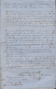
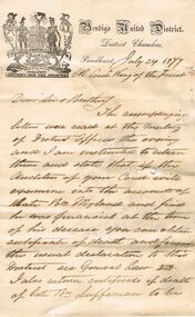
Letter written on paper with letterhead and crest and dated July 24 1877. The writer says the accompanying letters were read and he was entrusted to return them and state that if the Auditors of the Court will examine the accounts of late Bro Weylance and find him financial at the time of his decease you can obtain certificate of death and forward the usual declaration to this Sistrict. Also a reference to General Law 23. He also says he will return certificate of death of late Bro Luffsman to be filled in by the Surgeon - Cause of Death. Signed John Waller. Bendigo United District impression stamp on the paper.societies, aof, correspondence, ancient order of foresters no 3770 collection - letter, court king of the forest, weylance, luffsman, john waller -
 Bendigo Historical Society Inc.
Document - MARTIN BEST CONSORT, Post 1977
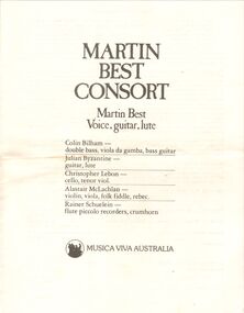
Martin Best Consort. Voice, guitar, lute. Colin Bilham; double bass, viola da gamba, bass guitar. Julian Byzantine: Guitar, lute. Christopher Lebon: cello, tenor viol. Alastair McLachlan: violin, viola, folk fiddle, rebec. Rainer Schulein: flute piccolo recorders, crumhorn. Musica Viva Australia. The Martin Best Consort is a unique group of six musicians. Each of its members has brought his own individual talents and experience to bear on its work. The result is one of the loveliest and most unusual textures in British music. Its foundation rests on Martin himself as . . . Program. Sounds And Sweet Airs: a garland for William Shakespeare by Guy Woolfenden. Guy Woolfenden is Musical Director of the Royal Shakspeare Company. As well as his work for them, he has written music for films and television. His musical. . . . Musica Viva gratefully acknowledges the financial assistance of the Music Board of the Australia Council and the State Governments of N.S.W., Queensland , Tasmania and Victoria. The special assistance of the British Council for the tour of the Martin Best Consort is gratefully acknowledged. Post 1977program, music, musica viva australia, martin best consort. voice, guitar, lute. colin bilham; double bass, viola da gamba, bass guitar. julian byzantine: guitar, lute. christopher lebon: cello, tenor viol. alastair mclachlan: violin, viola, folk fiddle, rebec. rainer schulein: flute piccolo recorders, crumhorn. musica viva australia. its foundation william shakespeare by guy woolfenden. royal shakspeare company.. . . musica viva music board of the australia council and the state governments of n.s.w., queensland , tasmania and victoria. british council post 1977 -
 Bendigo Historical Society Inc.
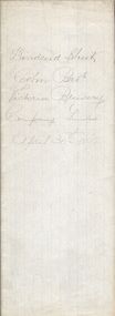
Document - COHN BROTHERS COLLECTION: HANDWRITTEN DIVIDEND SHEET DATED 1892
Folded paper sheet with 'Dividend Sheet, Cohn Bros Victoria Brewery Company Limited April 30th 1892' written on top fold. Numerous Brown Stamp duty one penny attached. Shareholder names and their holdings listed. Summary of annual company financial affairs pencilled on back fold.bendigo, industry, cohn bros brewery -
 Port Melbourne Historical & Preservation Society
Document - Waterside Workers Federation Financial Ticket, 1936 - 1938
... Federation Financial Ticket. Late 1930s Document Waterside Workers ...Waterside Workers Federation Financial Ticket. Late 1930spiers and wharves - waterside workers, percy allan may