Showing 386 items
matching heritage and environment
-
 Conservation Volunteers
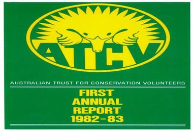
The first-ever ATCV Annual Report 1982-3, ATCV Annual Report 1982-3, 1983
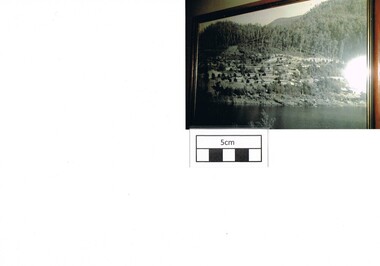
Topics covered:Lists of achievements, officers, benefactors, accounts: priorities for 1983-4; Work featured includes Yarrowee River, Ballarat; Mount Worth; Wilson's Promontory & Port Campbell National Park, Mooramong heritage property,; donattion of first aid boxes by Ballarat School of MinesThis item is significant as it was the first annual report of a then fledgling organisation. It portrays the enthusiasm of board and volunteers to do work for the environment. A4 17PP booklet, black and white printing, 15 b/w photographsGreen and yellow cover featuring 'echidna logo' and text AUSTRALIAN TRUST FOR CONSERVATION VOLUNTEERS - FIRST ANNUAL REPORT 1982-3atcv australian trust for conservation volunteers yarrowee river ballarat mount worth wilsons promontory port campbell - national park - mooramong - first aid - ballarat school of mines -
 Greensborough Historical Society
Document, Victoria. Department of Environment Land Water and Planning, Proposed planning changes for Austin Hospital, 28/10/2016
Information on proposed changes to heritage overlays on the Austin Hospital site on Studley Road Heidelberg4p. coloured information sheet, with one page covering letter from the Government Land Standing Advisory Committeeaustin hospital -
 Greensborough Historical Society
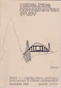
Book, Heidelberg Conservation Study: Part 1 Historic Buildings and Areas Assessment, 1985_
Report prepared by Graeme Butler on behalf of City of Heidelberg and Heidelberg Heritage Advisory Committee. Area covered is from Eaglemont in the south to Macleod in the north.This study identifies neighbourhood character, documents past development and the capacity of the environment for future development.Part one of set of three books. Paperback, 189 pages, Illus., maps. 2 copies.Stamps: Yarra Plenty Regional Library Service, and, Withdrawnheidelberg, macleod, heidelberg heritage advisory committee, graeme butler, plenty river, eaglemont -
 Greensborough Historical Society
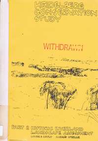
Book, Heidelberg Conservation Study: Part 2: Historic Riverland Landscape Assessment. Revised 1987, 1987_
Report prepared by Loder and Bayly and Marilyn McBriar on behalf of City of Heidelberg and Heidelberg Heritage Advisory Committee. Area covered is from Darebin Parklands in the south to Plenty River at Yallambie in the north. Revised 1987.This study identifies neighbourhood character, documents past development and the capacity of the environment for future development with particular emphasis on the river precincts - Plenty River, Yarra River and Darebin Creek.Part three of set of three books. Paperback, 333 pages, Illus., maps. 2 copies.Stamps: Yarra Plenty Regional Library Service, and, Withdrawnheidelberg, macleod, heidelberg heritage advisory committee, marilyn mcbriar, plenty river, yarra river, darebin creek -
 Kiewa Valley Historical Society
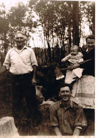
Photograph of Kiewa Valley Pioneer Family, Three Generations of Kiewa Valley Pioneer Family (Coopers), late 1900s'
This historical family photograph spans three generations of the Cooper Family, a pioneer family, still residing in the Kiewa Valley. The large axe held by Pat was a handy tool for pioneer families to chop down trees for land clearing, building sheds and fences, outhouses and fire wood. This photograph was taken during a time where both male and females did some heavy lifting and processing. The rural sector at this point in time was physically a hard location for both sexes. The segregation of the sexes into specific job categories was some times non existent although household "chores" was in the main a woman's domain. The rural sector was in this point of time one which women were highly respected and the unwritten law of providing "assistance" and "reverence" by men in such actions as, socially opening doors, tipping the cap, offering a sturdy arm for support and refraining from doing or saying anything "uncouth" in a woman's presence. It was in a time when women's liberation was just starting to grow strength. Rural areas, on the hole, took longer to interfuse "city" hatched norms of behaviour. This photograph of a pioneer family still residing in the Kiewa Valley demonstrates not only the close protective environment that the valley has on all its inhabitants but also the close bonding that neighbors have towards each other. The term "God's gifted country" fits warmly with all the settlements in the valley. The relatively isolated (physically, visually and communications wise) has since post World War II been whittled away by faster and vastly improved communications with "the outside" world. The strength of commitment to the rural life can be seen in the faces of the family members in this photograph. The proud heritage is displayed without any external pressure. This large black and white family photograph is a reproduction on Fujicolor Crystal Archive Paper manufactured by Fujifilm. It is 200gsm matt finished paper with no borders. On the reverse side, written in pencil "Ted Cooper sitting aged 24-25, Pat Amery (Ted's youngest sister) holding Ted's eldest son Doug and Ted's father John Franklin Cooper(22-8-1892)"john cooper, ted cooper, pat amery, doug cooper, pioneer family kiewa valley -
 Kiewa Valley Historical Society
Photograph Bogong, Bogong Township Circa 1950, circa 1940s to 1950s
The Bogong Village was originally constructed (1937-1940) by the State Electricity Commission to house, engineers and construction workers working on the Kiewa Hydroelectric Scheme. These workers were initially settled in 26 houses and were mainly of European heritage. At the completion of the scheme, in the 1960's, the village was opened to public/tourism use. This photograph shows the village before beautification for tourism was introduced and "bare bones" homes and village usage existed.This photo clearly presents a period of restricted human occupation of a very fragile Alpine environment(up to 4000 workmen involved). This was the beginning of a planned and controlled form of sustainable tourist orientated development of the Victorian Alps and high plains region. The Bogong Township was the base camp for workers employed by the State Electricity Commission. After the construction phase was completed, the planning and controls originating from this period have been modified to allow a greater public access of this unique environment.Photograph of a framed glass enclosed black and white photograph of the Bogong settlement Paper details "KodakXtraLife paper" on back of photo. bogong village, bogong township, sec alpine constructions, hydro, kiewa scheme -
 Kiewa Valley Historical Society
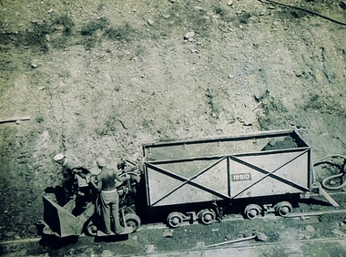
Photograph Shovel Truck, Shovel Loading Rail Truck, circa 1950s
This item shows the excavation of the side of a railway track using a pneumatic shovel and a rail mounted truck by two workmen. The period covered was well before State Health and Safety requirements, such as helmets, became law. It also details that the workmen were from European heritage as their head coverings were a handkerchief knotted at each corner. This was typical for workmen of this heritage, others used caps or hats or no head covering at all (the macho male look)The photograph of this item was one of many depicting great achievements and opening up the region. A visual link or time capsule of the 1950s rural/mining sectors clashing with the established rural industriesThis photo depicts the time (1950's) and place (Bogong and Mount Beauty) where construction workers had an immense impact, not only on the physical environment but also on the social and economic development of the Victorian Alps region. The fast expansion of smaller settlements brought about increased pressures on the welfare viability of certain subgroups within the region e.g. farming, droving and commerce (caravan hawkers versus static shops). These changes brought about a heightened awareness by both local and State Governments to upgrade not only facilities within the region but also access to the region. Black and white photo of two workmen on a rail mounted shovel truck. The photo is of good definition allowing a clear view of the subject matter. The paper is semi gloss.On the back of the photo, paper suppliers etchings are "Kodak XtraLife II paper"mining, hydro electricity, victorian alps, construction camps, earth moving machines -
 Kiewa Valley Historical Society
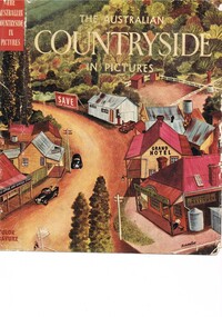
Book - Reference Countryside, The Australian Countryside in Pictures, circa 1950s
This book is a "snapshot" in time (1950s) detailing life in Australia covering a time when a "man's word and handshake" were his moral and quasi legal bond, and the now relative defunct saying "smoko" (having a "time out" from work for a cigarette and tea or coffee). The book spans an era where the male was still the "head" of the family even though for a majority of families the women took on the many "male only" roles during the World War II period. This shift in the leadership of the family hierarchy is mentioned, so ever slightly, (not to offend the still predominant macho male image) in both rural and city environments. The effects of the war, and later the push for women's emancipation and equality in both family, social, workplace and political areas of life, since this book was published, is now finally resolved. However there are still some sections of the recent migrate population where this male dominance is causing a few problems.The significance of this book is not only because it was donated by Mrs C. Roper ( from the Roper Family, a pioneer Kiewa Valley and surrounding Region family - originally beef cattle graziers) but also a Kiewa Valley resident and family, experiencing the shift in the social and economical life of post World War II rural Australia. The strong heritage link to this region of many families still residing within its boundaries, is a clear affirmation of the bond that the Kiewa Valley and its Regions have upon family unity. This unity within the rural environment is something that is attracting more and more families from sometimes alienating city life.This printed coloured sketched, or painted paper sleeve of the book is freely wrapped over a dark red hard cover. Into the front of the cover is pressed a standing pose of a farmer with long sleeves rolled up over his elbows. Behind him and to the right are what appears to be three sacks of wheat and next to him is a merino sheep. To the left and down are two dogs one with a fox in its jaws. The book contains 240 pages, 300 illustrations in gravure and 25 pictures in full colour. The inside fly leaf is a colour photograph of a rural scene with dirt road running in the centre and to the left a farm house and a five bay open storage barnOn the tittle page is a signature "C Roper"country life, australian "outback", rural industries, life on the land, swag-man of the bush -
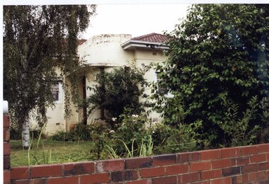
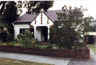
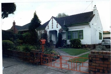
 Glen Eira Historical Society
Photograph, Beauville Avenue, 17, Murrumbeena, 2001
Originally labelled "Beauville Estate, Established 1936, Still Thriving 65 years on, 10th March 2001", the Beauville Estate Album contains colour photographs of houses in the Estate. They were taken around the time of the Beauville Estate’s 65th Heritage Celebration held on 10/03/2001 and donated to the Caulfield Historical Society shortly afterwards. Photographer unknown.City of Glen Eira’s Heritage Management Plan Vol 2 p79 (this is p84 of the pdf version) – HO12 Beauville Estate and environs, Murrumbeena: The Beauville Historic Area is important at the State level as the first large housing estate undertaken by the AV Jennings Construction Co, later Jennings Group Limited, Victoria’s largest home builder. It is important also as a very early estate development incorporating a range of features other than houses and including made roads, shops and recreation facilities. In this respect it was the forerunner of the comprehensively planned housing estate of the post war era. The estate is distinguished by its aesthetic values, as is the earlier and comparable Hillcrest Estate, which are formed by a combination of restrained diversity in house styles, with the exception of no. 30 in the emerging International style, and by a landscaped garden environment. Colour photograph of the porch of an unpainted variegated brown brick house. The porch features decorative brickwork with arched entrances, lantern light and cast iron gates. murrumbeena, houses, beauville avenue, architectural styles, 1930's, inter war style, a.v. jennings, av jennings, jennings, brick houses, beauville estate, porches, arches, sir albert victor jennings, a v jennings construction co, beauville estate heritage area, glen eira city council, architectural features, jennings group limited, land subdivision, gardens, beauville historic area, brick features, cast iron gates, cast iron lights -
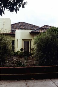
 Glen Eira Historical Society
Photograph, Beauville Avenue, 18, Murrumbeena, 2001
Originally labelled "Beauville Estate, Established 1936, Still Thriving 65 years on, 10th March 2001", the Beauville Estate Album contains colour photographs of houses in the Estate. They were taken around the time of the Beauville Estate’s 65th Heritage Celebration held on 10/03/2001 and donated to the Caulfield Historical Society shortly afterwards. Photographer unknown.City of Glen Eira’s Heritage Management Plan Vol 2 p79 (this is p84 of the pdf version) – HO12 Beauville Estate and environs, Murrumbeena: The Beauville Historic Area is important at the State level as the first large housing estate undertaken by the AV Jennings Construction Co, later Jennings Group Limited, Victoria’s largest home builder. It is important also as a very early estate development incorporating a range of features other than houses and including made roads, shops and recreation facilities. In this respect it was the forerunner of the comprehensively planned housing estate of the post war era. The estate is distinguished by its aesthetic values, as is the earlier and comparable Hillcrest Estate, which are formed by a combination of restrained diversity in house styles, with the exception of no. 30 in the emerging International style, and by a landscaped garden environment. Colour photograph of cream rendered house. Other features include a curved porch with pillars, tiled roof and low unpainted brick fence in the foreground. murrumbeena, houses, beauville avenue, architectural styles, 1930's, inter war style, a.v. jennings, av jennings, jennings, brick houses, beauville estate, porches, sir albert victor jennings, a v jennings construction co, beauville estate heritage area, glen eira city council, architectural features, jennings group limited, land subdivision, gardens, beauville historic area, rendered houses, brick fences -
 Glen Eira Historical Society
Photograph, Beauville Avenue, 19, Murrumbeena, 2001
Originally labelled "Beauville Estate, Established 1936, Still Thriving 65 years on, 10th March 2001", the Beauville Estate Album contains colour photographs of houses in the Estate. They were taken around the time of the Beauville Estate’s 65th Heritage Celebration held on 10/03/2001 and donated to the Caulfield Historical Society shortly afterwards. Photographer unknown.City of Glen Eira’s Heritage Management Plan Vol 2 p79 (this is p84 of the pdf version) – HO12 Beauville Estate and environs, Murrumbeena: The Beauville Historic Area is important at the State level as the first large housing estate undertaken by the AV Jennings Construction Co, later Jennings Group Limited, Victoria’s largest home builder. It is important also as a very early estate development incorporating a range of features other than houses and including made roads, shops and recreation facilities. In this respect it was the forerunner of the comprehensively planned housing estate of the post war era. The estate is distinguished by its aesthetic values, as is the earlier and comparable Hillcrest Estate, which are formed by a combination of restrained diversity in house styles, with the exception of no. 30 in the emerging International style, and by a landscaped garden environment. Colour photograph of white rendered house. Other features include an enclosed porch with a curved wall and cast iron entrance door, tiled roof, chimney and low unpainted brick fence in the foreground with a garden behind. murrumbeena, houses, beauville avenue, architectural styles, 1930's, inter war style, a.v. jennings, av jennings, jennings, brick houses, beauville estate, porches, sir albert victor jennings, a v jennings construction co, beauville estate heritage area, glen eira city council, architectural features, jennings group limited, land subdivision, gardens, beauville historic area, rendered houses, curved porches, cast iron work, chimneys, brick fences -
 Glen Eira Historical Society
Photograph, Beauville Avenue, 20, Murrumbeena, 2001
Originally labelled "Beauville Estate, Established 1936, Still Thriving 65 years on, 10th March 2001", the Beauville Estate Album contains colour photographs of houses in the Estate. They were taken around the time of the Beauville Estate’s 65th Heritage Celebration held on 10/03/2001 and donated to the Caulfield Historical Society shortly afterwards. Photographer unknown.City of Glen Eira’s Heritage Management Plan Vol 2 p79 (this is p84 of the pdf version) – HO12 Beauville Estate and environs, Murrumbeena: The Beauville Historic Area is important at the State level as the first large housing estate undertaken by the AV Jennings Construction Co, later Jennings Group Limited, Victoria’s largest home builder. It is important also as a very early estate development incorporating a range of features other than houses and including made roads, shops and recreation facilities. In this respect it was the forerunner of the comprehensively planned housing estate of the post war era. The estate is distinguished by its aesthetic values, as is the earlier and comparable Hillcrest Estate, which are formed by a combination of restrained diversity in house styles, with the exception of no. 30 in the emerging International style, and by a landscaped garden environment. Colour photograph of glimpses of a white rendered house seen behind a low unpainted brick fence with a hedge and " 20" on the white letterbox beside the driveway. Other features seen through the trees include tiled roof, a porch with unpainted brick edging on the doorway and a black cast iron entrance gate.murrumbeena, houses, beauville avenue, architectural styles, 1930's, inter war style, a.v. jennings, av jennings, jennings, brick houses, beauville estate, porches, letterboxes, sir albert victor jennings, a v jennings construction co, beauville estate heritage area, glen eira city council, architectural features, jennings group limited, land subdivision, gardens, beauville historic area, brick fences, rendered houses, cast iron work, brick features -
 Glen Eira Historical Society
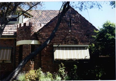
Photograph, Beauville Avenue, 22, Murrumbeena, 2001
Originally labelled "Beauville Estate, Established 1936, Still Thriving 65 years on, 10th March 2001", the Beauville Estate Album contains colour photographs of houses in the Estate. They were taken around the time of the Beauville Estate’s 65th Heritage Celebration held on 10/03/2001 and donated to the Caulfield Historical Society shortly afterwards. Photographer unknown.City of Glen Eira’s Heritage Management Plan Vol 2 p79 (this is p84 of the pdf version) – HO12 Beauville Estate and environs, Murrumbeena: The Beauville Historic Area is important at the State level as the first large housing estate undertaken by the AV Jennings Construction Co, later Jennings Group Limited, Victoria’s largest home builder. It is important also as a very early estate development incorporating a range of features other than houses and including made roads, shops and recreation facilities. In this respect it was the forerunner of the comprehensively planned housing estate of the post war era. The estate is distinguished by its aesthetic values, as is the earlier and comparable Hillcrest Estate, which are formed by a combination of restrained diversity in house styles, with the exception of no. 30 in the emerging International style, and by a landscaped garden environment. Colour photograph of unpainted brick house with decorative brick features. Other features include a curved wall porch with a crenelated parapet, tiled roof, dormer window and striped awnings on the ground floor windows. murrumbeena, houses, beauville avenue, architectural styles, 1930's, inter war style, a.v. jennings, av jennings, jennings, brick houses, beauville estate, porches, sir albert victor jennings, a v jennings construction co, beauville estate heritage area, glen eira city council, architectural features, jennings group limited, land subdivision, gardens, beauville historic area, brick features, dormer windows, striped awnings, towers -
 Glen Eira Historical Society
Photograph, Beauville Avenue, 22, Murrumbeena, 2001
Originally labelled "Beauville Estate, Established 1936, Still Thriving 65 years on, 10th March 2001", the Beauville Estate Album contains colour photographs of houses in the Estate. They were taken around the time of the Beauville Estate’s 65th Heritage Celebration held on 10/03/2001 and donated to the Caulfield Historical Society shortly afterwards. Photographer unknown.City of Glen Eira’s Heritage Management Plan Vol 2 p79 (this is p84 of the pdf version) – HO12 Beauville Estate and environs, Murrumbeena: The Beauville Historic Area is important at the State level as the first large housing estate undertaken by the AV Jennings Construction Co, later Jennings Group Limited, Victoria’s largest home builder. It is important also as a very early estate development incorporating a range of features other than houses and including made roads, shops and recreation facilities. In this respect it was the forerunner of the comprehensively planned housing estate of the post war era. The estate is distinguished by its aesthetic values, as is the earlier and comparable Hillcrest Estate, which are formed by a combination of restrained diversity in house styles, with the exception of no. 30 in the emerging International style, and by a landscaped garden environment. Colour photograph of unpainted brick house with decorative brick features and also cream render features. Other features include a curved wall porch with a crenelated parapet, tiled roof, dormer window and striped awnings on the ground floor windows. A tree branch can be seen in the foreground.murrumbeena, houses, beauville avenue, architectural styles, 1930's, inter war style, a.v. jennings, av jennings, jennings, brick houses, beauville estate, porches, sir albert victor jennings, a v jennings construction co, beauville estate heritage area, glen eira city council, architectural features, jennings group limited, land subdivision, gardens, beauville historic area, towers, dormer windows, striped awnings, brick and cream render features -
 Glen Eira Historical Society
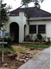
Photograph, Beauville Avenue, 23, Murrumbeena, 2001
Originally labelled "Beauville Estate, Established 1936, Still Thriving 65 years on, 10th March 2001", the Beauville Estate Album contains colour photographs of houses in the Estate. They were taken around the time of the Beauville Estate’s 65th Heritage Celebration held on 10/03/2001 and donated to the Caulfield Historical Society shortly afterwards. Photographer unknown.City of Glen Eira’s Heritage Management Plan Vol 2 p79 (this is p84 of the pdf version) – HO12 Beauville Estate and environs, Murrumbeena: The Beauville Historic Area is important at the State level as the first large housing estate undertaken by the AV Jennings Construction Co, later Jennings Group Limited, Victoria’s largest home builder. It is important also as a very early estate development incorporating a range of features other than houses and including made roads, shops and recreation facilities. In this respect it was the forerunner of the comprehensively planned housing estate of the post war era. The estate is distinguished by its aesthetic values, as is the earlier and comparable Hillcrest Estate, which are formed by a combination of restrained diversity in house styles, with the exception of no. 30 in the emerging International style, and by a landscaped garden environment. Colour photograph of white rendered house with the concrete path removed from the front garden . Other features include a semi enclosed porch with arched entrances and barrel tiled flat roof with four pillars. Property features also include a tiled roof, a concrete driveway and '23' on the adjacent mailbox. Bricks are scattered on dirt path in the front garden.murrumbeena, houses, beauville avenue, architectural styles, 1930's, inter war style, a.v. jennings, av jennings, jennings, brick houses, beauville estate, porches, arches, letterboxes, sir albert victor jennings, a v jennings construction co, beauville estate heritage area, glen eira city council, architectural features, jennings group limited, land subdivision, gardens, beauville historic area, rendered houses -
 Glen Eira Historical Society
Photograph, Beauville Avenue, 24, Murrumbeena, 2001
Originally labelled "Beauville Estate, Established 1936, Still Thriving 65 years on, 10th March 2001", the Beauville Estate Album contains colour photographs of houses in the Estate. They were taken around the time of the Beauville Estate’s 65th Heritage Celebration held on 10/03/2001 and donated to the Caulfield Historical Society shortly afterwards. Photographer unknown.City of Glen Eira’s Heritage Management Plan Vol 2 p79 (this is p84 of the pdf version) – HO12 Beauville Estate and environs, Murrumbeena: The Beauville Historic Area is important at the State level as the first large housing estate undertaken by the AV Jennings Construction Co, later Jennings Group Limited, Victoria’s largest home builder. It is important also as a very early estate development incorporating a range of features other than houses and including made roads, shops and recreation facilities. In this respect it was the forerunner of the comprehensively planned housing estate of the post war era. The estate is distinguished by its aesthetic values, as is the earlier and comparable Hillcrest Estate, which are formed by a combination of restrained diversity in house styles, with the exception of no. 30 in the emerging International style, and by a landscaped garden environment. Colour photograph of unpainted variegated brown brick house. Other features include a porch, tiled roof, striped window awning and low unpainted variegated brown brick fence in the foreground with "24" on the letterbox on top of the brick pillar beside the concrete driveway. Tall brown brick side fence.murrumbeena, houses, beauville avenue, architectural styles, 1930's, inter war style, a.v. jennings, av jennings, jennings, brick houses, beauville estate, porches, letterboxes, sir albert victor jennings, a v jennings construction co, beauville estate heritage area, glen eira city council, architectural features, jennings group limited, land subdivision, gardens, beauville historic area, brick fences -
 Glen Eira Historical Society
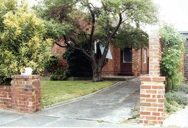
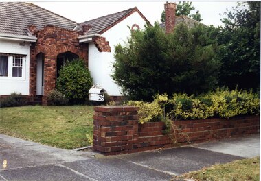
Photograph, Beauville Avenue, 26, Murrumbeena, 2001
Originally labelled "Beauville Estate, Established 1936, Still Thriving 65 years on, 10th March 2001", the Beauville Estate Album contains colour photographs of houses in the Estate. They were taken around the time of the Beauville Estate’s 65th Heritage Celebration held on 10/03/2001 and donated to the Caulfield Historical Society shortly afterwards. Photographer unknown.City of Glen Eira’s Heritage Management Plan Vol 2 p79 (this is p84 of the pdf version) – HO12 Beauville Estate and environs, Murrumbeena: The Beauville Historic Area is important at the State level as the first large housing estate undertaken by the AV Jennings Construction Co, later Jennings Group Limited, Victoria’s largest home builder. It is important also as a very early estate development incorporating a range of features other than houses and including made roads, shops and recreation facilities. In this respect it was the forerunner of the comprehensively planned housing estate of the post war era. The estate is distinguished by its aesthetic values, as is the earlier and comparable Hillcrest Estate, which are formed by a combination of restrained diversity in house styles, with the exception of no. 30 in the emerging International style, and by a landscaped garden environment. Colour photograph of white rendered house with unpainted brick features. Other features include a porch, tiled roof, and low unpainted brick fence in the foreground with "26" on the letterbox on top of the brick pillar beside the driveway.murrumbeena, houses, beauville avenue, architectural styles, 1930's, inter war style, a.v. jennings, av jennings, jennings, brick houses, beauville estate, porches, arches, letterboxes, sir albert victor jennings, a v jennings construction co, beauville estate heritage area, glen eira city council, architectural features, jennings group limited, land subdivision, gardens, beauville historic area -
 Glen Eira Historical Society
Photograph, Beauville Avenue, 27, Murrumbeena, 2001
Originally labelled "Beauville Estate, Established 1936, Still Thriving 65 years on, 10th March 2001", the Beauville Estate Album contains colour photographs of houses in the Estate. They were taken around the time of the Beauville Estate’s 65th Heritage Celebration held on 10/03/2001 and donated to the Caulfield Historical Society shortly afterwards. Photographer unknown.City of Glen Eira’s Heritage Management Plan Vol 2 p79 (this is p84 of the pdf version) – HO12 Beauville Estate and environs, Murrumbeena: The Beauville Historic Area is important at the State level as the first large housing estate undertaken by the AV Jennings Construction Co, later Jennings Group Limited, Victoria’s largest home builder. It is important also as a very early estate development incorporating a range of features other than houses and including made roads, shops and recreation facilities. In this respect it was the forerunner of the comprehensively planned housing estate of the post war era. The estate is distinguished by its aesthetic values, as is the earlier and comparable Hillcrest Estate, which are formed by a combination of restrained diversity in house styles, with the exception of no. 30 in the emerging International style, and by a landscaped garden environment. Colour photograph of white rendered house with unpainted variegated brown brick features and a later second storey addition. Other features include a porch, tiled roof, tall chimneys, window awnings and low unpainted matching brick fences in the foreground with "27" on the letterbox near the brick pillar beside the driveway.murrumbeena, houses, beauville avenue, architectural styles, 1930's, inter war style, a.v. jennings, av jennings, jennings, brick houses, beauville estate, porches, arches, sir albert victor jennings, a v jennings construction co, beauville estate heritage area, glen eira city council, architectural features, jennings group limited, land subdivision, gardens, beauville historic area, brick features, awnings, brick fences, rendered houses, letterboxes -
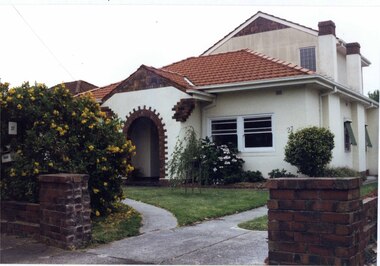
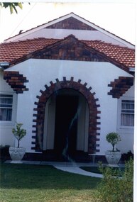 Glen Eira Historical Society
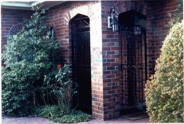
Photograph, Beauville Avenue, 27, Murrumbeena, 2001
Originally labelled "Beauville Estate, Established 1936, Still Thriving 65 years on, 10th March 2001", the Beauville Estate Album contains colour photographs of houses in the Estate. They were taken around the time of the Beauville Estate’s 65th Heritage Celebration held on 10/03/2001 and donated to the Caulfield Historical Society shortly afterwards. Photographer unknown.City of Glen Eira’s Heritage Management Plan Vol 2 p79 (this is p84 of the pdf version) – HO12 Beauville Estate and environs, Murrumbeena: The Beauville Historic Area is important at the State level as the first large housing estate undertaken by the AV Jennings Construction Co, later Jennings Group Limited, Victoria’s largest home builder. It is important also as a very early estate development incorporating a range of features other than houses and including made roads, shops and recreation facilities. In this respect it was the forerunner of the comprehensively planned housing estate of the post war era. The estate is distinguished by its aesthetic values, as is the earlier and comparable Hillcrest Estate, which are formed by a combination of restrained diversity in house styles, with the exception of no. 30 in the emerging International style, and by a landscaped garden environment. Colour photograph of the porch and surrounds for a white rendered house with unpainted variegated brown brick features and a later second storey addition. The porch has a wide decorative arched entrance, garden urns in front of the porch and a curved concrete path through the lawn to the porch. murrumbeena, houses, beauville avenue, architectural styles, 1930's, inter war style, a.v. jennings, av jennings, jennings, brick houses, beauville estate, porches, arches, sir albert victor jennings, a v jennings construction co, beauville estate heritage area, glen eira city council, architectural features, jennings group limited, land subdivision, gardens, beauville historic area, brick features, outdoor ornaments, rendered houses, gables -
 Glen Eira Historical Society
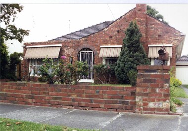
Photograph, Beauville Avenue, 28, Murrumbeena, 2001
Originally labelled "Beauville Estate, Established 1936, Still Thriving 65 years on, 10th March 2001", the Beauville Estate Album contains colour photographs of houses in the Estate. They were taken around the time of the Beauville Estate’s 65th Heritage Celebration held on 10/03/2001 and donated to the Caulfield Historical Society shortly afterwards. Photographer unknown.City of Glen Eira’s Heritage Management Plan Vol 2 p79 (this is p84 of the pdf version) – HO12 Beauville Estate and environs, Murrumbeena: The Beauville Historic Area is important at the State level as the first large housing estate undertaken by the AV Jennings Construction Co, later Jennings Group Limited, Victoria’s largest home builder. It is important also as a very early estate development incorporating a range of features other than houses and including made roads, shops and recreation facilities. In this respect it was the forerunner of the comprehensively planned housing estate of the post war era. The estate is distinguished by its aesthetic values, as is the earlier and comparable Hillcrest Estate, which are formed by a combination of restrained diversity in house styles, with the exception of no. 30 in the emerging International style, and by a landscaped garden environment. See Significance Statement in Glen Eira’s Heritage Management Plan by Andrew Ward (1996) Vol 2 p.79. Available from https://www.gleneira.vic.gov.au/media/4779/heritage_management_plan_volume_2.pdf (Note see p.84 of pdf)Colour photograph of unpainted variegated brown brick house with "Kileen 28" in cast iron on the front wall. Other features include a porch with white cast iron work door, tiled roof, chimney, striped window awnings and low unpainted brick fence with a brown metal letterbox in the foreground beside the driveway. The house has an unusual pitched roof with timber eave on the right side of the house.Kileen / 28murrumbeena, houses, beauville avenue, architectural styles, 1930's, inter war style, a.v. jennings, av jennings, jennings, brick houses, beauville estate, porches, arches, letterboxes, sir albert victor jennings, a v jennings construction co, beauville estate heritage area, glen eira city council, architectural features, jennings group limited, land subdivision, gardens, beauville historic area, cast iron work, house names, kileen, brick features, brick chimneys, striped awnings, brick fences, metal letterboxes, roofs -
 Glen Eira Historical Society
Photograph, Beauville Avenue, 29, Murrumbeena, 2001
Originally labelled "Beauville Estate, Established 1936, Still Thriving 65 years on, 10th March 2001", the Beauville Estate Album contains colour photographs of houses in the Estate. They were taken around the time of the Beauville Estate’s 65th Heritage Celebration held on 10/03/2001 and donated to the Caulfield Historical Society shortly afterwards. Photographer unknown.City of Glen Eira’s Heritage Management Plan Vol 2 p79 (this is p84 of the pdf version) – HO12 Beauville Estate and environs, Murrumbeena: The Beauville Historic Area is important at the State level as the first large housing estate undertaken by the AV Jennings Construction Co, later Jennings Group Limited, Victoria’s largest home builder. It is important also as a very early estate development incorporating a range of features other than houses and including made roads, shops and recreation facilities. In this respect it was the forerunner of the comprehensively planned housing estate of the post war era. The estate is distinguished by its aesthetic values, as is the earlier and comparable Hillcrest Estate, which are formed by a combination of restrained diversity in house styles, with the exception of no. 30 in the emerging International style, and by a landscaped garden environment. Colour photograph of cream rendered house with unpainted brown brick features. Other features include an enclosed porch with a porthole opening and stepped arched entrance and "29" on the porch wall. Other features of the property include a tiled roof, chimney with a circle decoration and low unpainted matching brown brick side fence in the foreground. murrumbeena, houses, beauville avenue, architectural styles, 1930's, inter war style, a.v. jennings, av jennings, jennings, brick houses, beauville estate, porches, arches, sir albert victor jennings, a v jennings construction co, beauville estate heritage area, glen eira city council, architectural features, jennings group limited, land subdivision, gardens, beauville historic area, rendered house, brick features, porthole windows, decorated chimneys, brick fences -
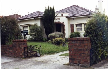 Glen Eira Historical Society
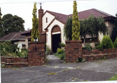
Photograph, Beauville Avenue, 31, Murrumbeena, 2001
Originally labelled "Beauville Estate, Established 1936, Still Thriving 65 years on, 10th March 2001", the Beauville Estate Album contains colour photographs of houses in the Estate. They were taken around the time of the Beauville Estate’s 65th Heritage Celebration held on 10/03/2001 and donated to the Caulfield Historical Society shortly afterwards. Photographer unknown.City of Glen Eira’s Heritage Management Plan Vol 2 p79 (this is p84 of the pdf version) – HO12 Beauville Estate and environs, Murrumbeena: The Beauville Historic Area is important at the State level as the first large housing estate undertaken by the AV Jennings Construction Co, later Jennings Group Limited, Victoria’s largest home builder. It is important also as a very early estate development incorporating a range of features other than houses and including made roads, shops and recreation facilities. In this respect it was the forerunner of the comprehensively planned housing estate of the post war era. The estate is distinguished by its aesthetic values, as is the earlier and comparable Hillcrest Estate, which are formed by a combination of restrained diversity in house styles, with the exception of no. 30 in the emerging International style, and by a landscaped garden environment. Colour photograph of white rendered house with unpainted brown brick features. Other features include a porch with "Milford" written above the arched entrance, a decorative brick rectangular panel, striped awnings, sash windows, chimneys, tiled roof and low unpainted brown brick fence in the foreground with "31" on the letterbox on top of the brick pillar beside the driveway.murrumbeena, houses, beauville avenue, architectural styles, 1930's, inter war style, a.v. jennings, av jennings, jennings, brick houses, beauville estate, porches, arches, sir albert victor jennings, a v jennings construction co, beauville estate heritage area, glen eira city council, architectural features, jennings group limited, land subdivision, gardens, beauville historic area, rendered houses, brick features, milford, house names, brick fences, letterboxes, striped awnings, sash windows -
 Glen Eira Historical Society
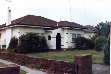
Photograph, Beauville Avenue, 32, Murrumbeena, 2001
Originally labelled "Beauville Estate, Established 1936, Still Thriving 65 years on, 10th March 2001", the Beauville Estate Album contains colour photographs of houses in the Estate. They were taken around the time of the Beauville Estate’s 65th Heritage Celebration held on 10/03/2001 and donated to the Caulfield Historical Society shortly afterwards. Photographer unknown.City of Glen Eira’s Heritage Management Plan Vol 2 p79 (this is p84 of the pdf version) – HO12 Beauville Estate and environs, Murrumbeena: The Beauville Historic Area is important at the State level as the first large housing estate undertaken by the AV Jennings Construction Co, later Jennings Group Limited, Victoria’s largest home builder. It is important also as a very early estate development incorporating a range of features other than houses and including made roads, shops and recreation facilities. In this respect it was the forerunner of the comprehensively planned housing estate of the post war era. The estate is distinguished by its aesthetic values, as is the earlier and comparable Hillcrest Estate, which are formed by a combination of restrained diversity in house styles, with the exception of no. 30 in the emerging International style, and by a landscaped garden environment. Colour photograph of beige rendered house with a porch, tiled roof, and low unpainted brown brick fence in the foreground with "32" on the brick pillar beside the driveway. Tall trees and shrubs obscure much of the house.murrumbeena, houses, beauville avenue, architectural styles, 1930's, inter war style, a.v. jennings, av jennings, jennings, brick houses, beauville estate, porches, sir albert victor jennings, a v jennings construction co, beauville estate heritage area, glen eira city council, architectural features, jennings group limited, land subdivision, gardens, beauville historic area, rendered houses, brick fences -
 Glen Eira Historical Society
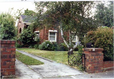
Photograph, Beauville Avenue, 33, Murrumbeena, 2001
Originally labelled "Beauville Estate, Established 1936, Still Thriving 65 years on, 10th March 2001", the Beauville Estate Album contains colour photographs of houses in the Estate. They were taken around the time of the Beauville Estate’s 65th Heritage Celebration held on 10/03/2001 and donated to the Caulfield Historical Society shortly afterwards. Photographer unknown.City of Glen Eira’s Heritage Management Plan Vol 2 p79 (this is p84 of the pdf version) – HO12 Beauville Estate and environs, Murrumbeena: The Beauville Historic Area is important at the State level as the first large housing estate undertaken by the AV Jennings Construction Co, later Jennings Group Limited, Victoria’s largest home builder. It is important also as a very early estate development incorporating a range of features other than houses and including made roads, shops and recreation facilities. In this respect it was the forerunner of the comprehensively planned housing estate of the post war era. The estate is distinguished by its aesthetic values, as is the earlier and comparable Hillcrest Estate, which are formed by a combination of restrained diversity in house styles, with the exception of no. 30 in the emerging International style, and by a landscaped garden environment. Colour photograph of unpainted variegated brown brick house with an arched porch, tiled roof, striped awnings, sash windows and low unpainted matching brick fence in the foreground with "33" on the brick pillar beside the driveway next to a low black cast iron gate. murrumbeena, houses, beauville avenue, architectural styles, 1930's, inter war style, a.v. jennings, av jennings, jennings, brick houses, beauville estate, porches, arches, sir albert victor jennings, a v jennings construction co, beauville estate heritage area, glen eira city council, architectural features, jennings group limited, land subdivision, gardens, beauville historic area, striped awnings, sash windows, brick walls, metal letterboxes, cast iron work -
 Glen Eira Historical Society
Photograph, Beauville Avenue, 34, Murrumbeena, 2001
Originally labelled "Beauville Estate, Established 1936, Still Thriving 65 years on, 10th March 2001", the Beauville Estate Album contains colour photographs of houses in the Estate. They were taken around the time of the Beauville Estate’s 65th Heritage Celebration held on 10/03/2001 and donated to the Caulfield Historical Society shortly afterwards. Photographer unknown.City of Glen Eira’s Heritage Management Plan Vol 2 p79 (this is p84 of the pdf version) – HO12 Beauville Estate and environs, Murrumbeena: The Beauville Historic Area is important at the State level as the first large housing estate undertaken by the AV Jennings Construction Co, later Jennings Group Limited, Victoria’s largest home builder. It is important also as a very early estate development incorporating a range of features other than houses and including made roads, shops and recreation facilities. In this respect it was the forerunner of the comprehensively planned housing estate of the post war era. The estate is distinguished by its aesthetic values, as is the earlier and comparable Hillcrest Estate, which are formed by a combination of restrained diversity in house styles, with the exception of no. 30 in the emerging International style, and by a landscaped garden environment. Colour photograph of white rendered, corner house with unpainted variegated brown brick features. Other features include a wide arched porch, tiled roof, tall brick chimney, cast iron work black porch door, window awnings and low unpainted matching brick fence in the foreground with "34" on the white metal letterbox on top of the right brick pillar beside the concrete pathway leading to the porch. Well-established garden including 2 matching pencil pines.murrumbeena, houses, beauville avenue, architectural styles, 1930's, inter war style, a.v. jennings, av jennings, jennings, brick houses, beauville estate, porches, sir albert victor jennings, a v jennings construction co, beauville estate heritage area, glen eira city council, architectural features, jennings group limited, land subdivision, gardens, beauville historic area, rendered houses, corner houses, brick features, awnings, brick fences, metal letterboxes, trees, cast iron work door -
 Glen Eira Historical Society
Photograph, Beauville Avenue, 35, Murrumbeena, 2001
Originally labelled "Beauville Estate, Established 1936, Still Thriving 65 years on, 10th March 2001", the Beauville Estate Album contains colour photographs of houses in the Estate. They were taken around the time of the Beauville Estate’s 65th Heritage Celebration held on 10/03/2001 and donated to the Caulfield Historical Society shortly afterwards. Photographer unknown. Windows frames, gutters and drain pipe all painted black but this is same property as 2104A-39 where they are painted green.City of Glen Eira’s Heritage Management Plan Vol 2 p79 (this is p84 of the pdf version) – HO12 Beauville Estate and environs, Murrumbeena: The Beauville Historic Area is important at the State level as the first large housing estate undertaken by the AV Jennings Construction Co, later Jennings Group Limited, Victoria’s largest home builder. It is important also as a very early estate development incorporating a range of features other than houses and including made roads, shops and recreation facilities. In this respect it was the forerunner of the comprehensively planned housing estate of the post war era. The estate is distinguished by its aesthetic values, as is the earlier and comparable Hillcrest Estate, which are formed by a combination of restrained diversity in house styles, with the exception of no. 30 in the emerging International style, and by a landscaped garden environment. See Significance Statement in Glen Eira’s Heritage Management Plan by Andrew Ward (1996) Vol 2 p.79. Available from https://www.gleneira.vic.gov.au/media/4779/heritage_management_plan_volume_2.pdf (Note see p.84 of pdf)Colour photograph of white rendered house with unpainted variegated brown brick features including a geometric pattern of 3 vertical shapes on the gable over the porch. Other features include a wide arched porch, tiled roof and low unpainted brown brick fence in the foreground with "35" on the reddish brown metal letterbox on top of the brick pillar beside the driveway. Garage has a matching brown brick feature wall.murrumbeena, houses, beauville avenue, architectural styles, 1930's, inter war style, a.v. jennings, av jennings, jennings, brick houses, beauville estate, porches, letterboxes, sir albert victor jennings, a v jennings construction co, beauville estate heritage area, glen eira city council, architectural features, jennings group limited, land subdivision, gardens, beauville historic area, rendered houses, brick features, arches, brick fences, garages (private), gables -
 Glen Eira Historical Society
Photograph, Beauville Avenue, 35, Murrumbeena, 2001
Originally labelled "Beauville Estate, Established 1936, Still Thriving 65 years on, 10th March 2001", the Beauville Estate Album contains colour photographs of houses in the Estate. They were taken around the time of the Beauville Estate’s 65th Heritage Celebration held on 10/03/2001 and donated to the Caulfield Historical Society shortly afterwards. Photographer unknown. Windows frames, gutters and drain pipe all painted green but this is same property as 2104A-38 where they are painted black.City of Glen Eira’s Heritage Management Plan Vol 2 p79 (this is p84 of the pdf version) – HO12 Beauville Estate and environs, Murrumbeena: The Beauville Historic Area is important at the State level as the first large housing estate undertaken by the AV Jennings Construction Co, later Jennings Group Limited, Victoria’s largest home builder. It is important also as a very early estate development incorporating a range of features other than houses and including made roads, shops and recreation facilities. In this respect it was the forerunner of the comprehensively planned housing estate of the post war era. The estate is distinguished by its aesthetic values, as is the earlier and comparable Hillcrest Estate, which are formed by a combination of restrained diversity in house styles, with the exception of no. 30 in the emerging International style, and by a landscaped garden environment. Colour photograph of white rendered house with unpainted variegated brown brick features including a geometric pattern of 3 vertical shapes on the gable over the porch. Other features include a wide arched porch, tiled roof and low unpainted reddish brown brick fence in the foreground with "35" on the reddish brown metal letterbox on top of the brick pillar beside the driveway. There are low, red, wrought iron gates across the driveway entrance. Garage has a matching brown brick feature wall.murrumbeena, houses, beauville avenue, architectural styles, 1930's, inter war style, a.v. jennings, av jennings, jennings, brick houses, beauville estate, porches, letterboxes, sir albert victor jennings, a v jennings construction co, beauville estate heritage area, glen eira city council, architectural features, jennings group limited, land subdivision, gardens, beauville historic area, rendered houses, brick features, arches, brick fences, garages (private), gables -
 Glen Eira Historical Society
Photograph, Beauville Avenue, 36, Murrumbeena, 2001
Originally labelled "Beauville Estate, Established 1936, Still Thriving 65 years on, 10th March 2001", the Beauville Estate Album contains colour photographs of houses in the Estate. They were taken around the time of the Beauville Estate’s 65th Heritage Celebration held on 10/03/2001 and donated to the Caulfield Historical Society shortly afterwards. Photographer unknown.City of Glen Eira’s Heritage Management Plan Vol 2 p79 (this is p84 of the pdf version) – HO12 Beauville Estate and environs, Murrumbeena: The Beauville Historic Area is important at the State level as the first large housing estate undertaken by the AV Jennings Construction Co, later Jennings Group Limited, Victoria’s largest home builder. It is important also as a very early estate development incorporating a range of features other than houses and including made roads, shops and recreation facilities. In this respect it was the forerunner of the comprehensively planned housing estate of the post war era. The estate is distinguished by its aesthetic values, as is the earlier and comparable Hillcrest Estate, which are formed by a combination of restrained diversity in house styles, with the exception of no. 30 in the emerging International style, and by a landscaped garden environment. Colour photograph of white rendered house with a wide porch gated by a black cast iron decorative door and a column feature to the right, chimney, tiled roof and a low unpainted brick fence topped by a black cast iron decorative fence in the foreground. murrumbeena, houses, beauville avenue, architectural styles, 1930's, inter war style, a.v. jennings, av jennings, jennings, brick houses, beauville estate, porches, sir albert victor jennings, a v jennings construction co, beauville estate heritage area, glen eira city council, architectural features, jennings group limited, land subdivision, gardens, beauville historic area, arches, rendered houses, cast iron work doors, chimneys, cast iron work fences -
 Glen Eira Historical Society
Photograph, Beauville Avenue, 37, Murrumbeena, 2001
Originally labelled "Beauville Estate, Established 1936, Still Thriving 65 years on, 10th March 2001", the Beauville Estate Album contains colour photographs of houses in the Estate. They were taken around the time of the Beauville Estate’s 65th Heritage Celebration held on 10/03/2001 and donated to the Caulfield Historical Society shortly afterwards. Photographer unknown.City of Glen Eira’s Heritage Management Plan Vol 2 p79 (this is p84 of the pdf version) – HO12 Beauville Estate and environs, Murrumbeena: The Beauville Historic Area is important at the State level as the first large housing estate undertaken by the AV Jennings Construction Co, later Jennings Group Limited, Victoria’s largest home builder. It is important also as a very early estate development incorporating a range of features other than houses and including made roads, shops and recreation facilities. In this respect it was the forerunner of the comprehensively planned housing estate of the post war era. The estate is distinguished by its aesthetic values, as is the earlier and comparable Hillcrest Estate, which are formed by a combination of restrained diversity in house styles, with the exception of no. 30 in the emerging International style, and by a landscaped garden environment. See Significance Statement in Glen Eira’s Heritage Management Plan by Andrew Ward (1996) Vol 2 p.79. Available from https://www.gleneira.vic.gov.au/media/4779/heritage_management_plan_volume_2.pdf (Note see p.84 of pdf)Colour photograph of white rendered house with unpainted variegated brown brick features including a wide brick band around the house. Other features include an open porch with brick pillar, striped awning on side windows, tiled roof, chimneys with identical brick features and low unpainted matching brick fence in the foreground with "37" on the brick pillar and white cast iron gate beside the driveway.murrumbeena, houses, beauville avenue, architectural styles, 1930's, inter war style, a.v. jennings, av jennings, jennings, brick houses, beauville estate, porches, sir albert victor jennings, a v jennings construction co, beauville estate heritage area, glen eira city council, architectural features, jennings group limited, land subdivision, gardens, beauville historic area, rendered houses, brick features, striped awnings, chimneys, brick fences, cast iron gates -
 Glen Eira Historical Society
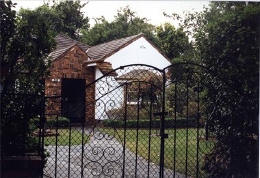
Photograph, Beauville Avenue, 39, Murrumbeena, 2001
Originally labelled "Beauville Estate, Established 1936, Still Thriving 65 years on, 10th March 2001", the Beauville Estate Album contains colour photographs of houses in the Estate. They were taken around the time of the Beauville Estate’s 65th Heritage Celebration held on 10/03/2001 and donated to the Caulfield Historical Society shortly afterwards. Photographer unknown.City of Glen Eira’s Heritage Management Plan Vol 2 p79 (this is p84 of the pdf version) – HO12 Beauville Estate and environs, Murrumbeena: The Beauville Historic Area is important at the State level as the first large housing estate undertaken by the AV Jennings Construction Co, later Jennings Group Limited, Victoria’s largest home builder. It is important also as a very early estate development incorporating a range of features other than houses and including made roads, shops and recreation facilities. In this respect it was the forerunner of the comprehensively planned housing estate of the post war era. The estate is distinguished by its aesthetic values, as is the earlier and comparable Hillcrest Estate, which are formed by a combination of restrained diversity in house styles, with the exception of no. 30 in the emerging International style, and by a landscaped garden environment. Colour photograph of white rendered house with unpainted variegated brown brick features. Features include a large brick porch with decorative cast iron door, tiled roof and decorative cast iron entrance gates.murrumbeena, houses, beauville avenue, architectural styles, 1930's, inter war style, a.v. jennings, av jennings, jennings, brick houses, beauville estate, porches, sir albert victor jennings, a v jennings construction co, beauville estate heritage area, glen eira city council, architectural features, jennings group limited, land subdivision, gardens, beauville historic area, rendered houses, brick features, cast iron work door, cast iron work gates