Showing 254 items
matching original post office.
-
 Ballarat Tramway Museum
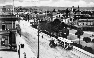
Photograph - Black & White Photograph/s, c1905
Black and white print with negative (N148) of an ESCo tram descending the Sturt St. hill from Lydiard St. North towards Grenville St. Photograph taken from possibly the post office. looking south east. Photo taken soon after opening as tram is not fitted with a destination box. Has horse drawn vehicle and person on bicycle travelling up hill alongside the tram indicating traffic arrangements at the time. Post office steps in photograph as well as Sutton store, Yankee Doodle store and Morris draper shop. Photo title "Sturt St. Ballarat". Another two tramcars at end of Bridge St. Copy negative and photograph by John Phillips of a Postcard High Res Images added 5/3/2011. Original neg scanned at hi res and updated 11/5/2020.trams, tramways, sturt st, esco, grenville st, bridge st -
 Ballarat Tramway Museum
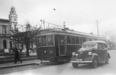
Photograph - Black & White Photograph/s, Wal Jack, Jul. 1946
Yields information about the appearance of one of Ballarat's bogie tram No. 15 soon after its arrival in Ballarat and the type of motor vehicle in use at the time.Black and white photograph of the Ballarat Bogie tram No. 15, Sturt St, July 1946. Photo by Wal Jack. A motor car is alongside the tram. Has the post office in the background. On Kodak Velox paper. Original negative scanned at hi res and image updated 1/6/2020.On rear in pencil, "Ballarat No. 15, Sturt St, July 1946."tramways, trams, bogie trams, sturt st, tram 15 -
 Ballarat Tramway Museum
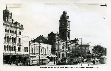
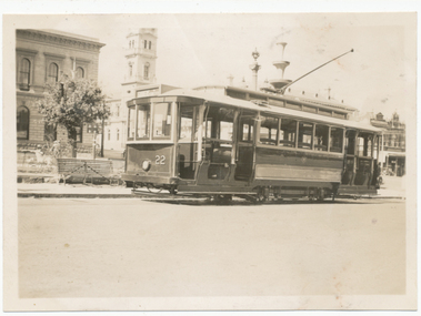
Photograph - Black & White Photograph/s, Murray Views, Murray Views No. 26 City Hall and Sturt St Ballarat Vic, c1950
Demonstrates a typical street view following the delivery of the bogie trams following the second world war and the street scape at the time. Able to determine the tramcar numbers. Yields information about the era of the photograph.B&W print, postcard print of Sturt St Ballarat, looking towards the Town Hall from the Post Office, City terminus. Photo taken by Murray Views to form "Murray Views No. 26, City Hall and Sturt St, Ballarat Vic." No. 22 on south side and No. 34 on north side - see Hi-Res scans. Has the National Mutual, Town Hall and Myers and other buildings in the view. Photo taken c1950, prior to renumbering of No. 22. 2nd copy added 28-12-2021 - most likely a reproduction of the original as it does not have a postcard back.On reverse side - black ink stamp "E.G.Butland" On reverse of 2nd copy - "Ballarat, Sturt St, west from Lydiard Sts" and Keith Kings stamp.tramways, trams, sturt st, bogie trams, tramway centre, town hall, tram 22, tram 34 -
 Ballarat Tramway Museum
Negative - Copy, Ray Pearson
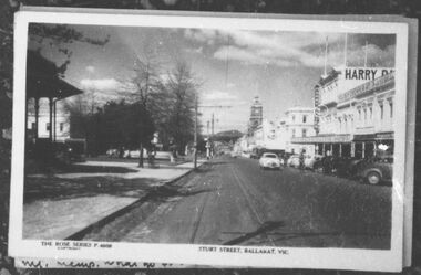
Yields information through postcard and some photos of Ballarat during the tramway eras - provides reference photographs for researchers to find original copies.Set of 12 copy negatives, of black and white photographs of Ballarat trams and postcards from Ray Pearson Collection, taken by Dave Macartney in 1975c. Original negative held in the negative file. Scanned at 2400 dpi and cropped as necessary. Images as shown replaced by scan from the original Ray Pearson Album provided by Mal Rowe, April 2020 or that there is a better image. .1 - Rose Series postcard P4609 - looking east along south of Sturt St, late 1940's. .2 - Rose Series postcard P10050 - Bridge St looking west. - see item 8975 for the actual postcard. .3 - Line up of trams in Sturt St West, for March 1968 Vintage train. .4 - Postcards or photo folder of Craigs Hotel and the Post Office, late 1900's. .5 - Postcard with Post Office in background, with horse trams crossing. .6 - Postcard or photo folder with Sturt St and "Greetings from Ballarat" .7 - Rose Series postcard P10044 - Lydiard St south, looking North - late 1940's. See item 8978 for the actual postcard. .8 - Rose Series postcard P13492 - Lower Sturt St, north side looking east. .9 - Rose Series postcard P13493 - Sturt St, south side, lower section, looking east. .10 - Postcard with horse tram arriving Grenville St, dated 5.2.04, has a miner and farmer on the right-hand side. .11 - Postcard of train at Ballarat railway station and a large crowd of people in the photo. .12 - Postcard or photo folder of an ESCo tram in Sturt St, with a "Souvenir of United States Fleet's visit to Australia" TMSV now possibly has these albums.trams, tramways, ballarat, postcards, sturt st, bridge st, post office -
 Ballarat Tramway Museum
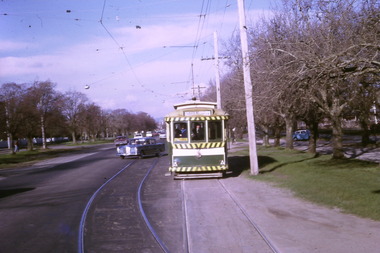
Photograph - Digital image Set of 10, Tony Smith, 1971
Yields information about Ballarat Tramways and trams prior to the closure of the tramway system.Set of 10 digital images of Ballarat trams prior to closure, scanned from original slides by Tony Smith, 1971 prior to closure of the system. .1 - 35 and 43 crossing at Urquhart St, Drummond St Sth. 35 outbound to Sebastopol, 43 to Lydiard St Nth. .2 - 35 in Lydiard St North, about to turn into Sturt St, with the Commonwealth Bank and National Mutual, Craig's Hotel in the background. Note the tram stop signs on the pole nearest to the Post Office. Tram has destination of Sebastopol. .3 - 39 and 41 at Grey St Loop, on a wet day. 39 showing Lydiard St Nth, 41 Special. .4 - two bogie trams (35?) and 41? Albert St, south of Grey St Loop. .5 - two bogies trams (41 and 35?) and a single trucker at the Sebastopol terminus. 41 showing Special. .6 - two bogies trams (41, 35?) and single trucker at the Grey St Loop, waiting for another bogie tram to arrive. Has a "Bounds" running alongside the tram. On a wet muddy day. .7 - two single truckers crossing at Gregory St loop, Lydiard St. Nth. - photo out of focus. .8 - 35 and single trucker crossing at ditto. .9 - 39 and another bogie tram waiting for two other trams to meet at Gregory St. loop. .10 - two single truckers crossing at the King St loop, Victoria St - out of focus and over exposed.trams, tramways, urquhart st, drummond st sth, lydiard st nth, sturt st, albert st, sebastopol, grey st loop, gregory st, king st, tram 35, tram 43, tram 39, tram 41 -
 Ballarat Tramway Museum
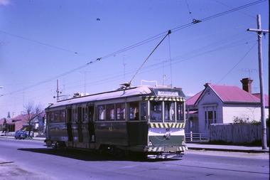
Photograph - Digital image Set of 10, Tony Smith, 1971
Yields information about Ballarat Tramways and trams prior to the closure of the tramway system.Set of 10 digital images of Ballarat trams prior to closure, scanned from original slides by Tony Smith, 1971 prior to closure of the system. .1 - 13 at the Parker St loop, Sturt St west waiting for another tram to arrive - Mercedes Benz car pull out around the stationary tramcar. .2 - 13 and another single trucker at the City terminus, north side of Sturt St. Note the conductor in the distance with a point bar about to hop onto the tram turning into Lydiard St North. Has the Post Office in the background. .3 - 26 arriving at the City stop, with the Mechanics Institute and Cooks Provide Hotel in the background. Tram has destination of Gardens via Drummond St North. .4 - 33 and 12 in Lydiard St Nth at Sturt St. 33 (Lydiard St Nth), 12 (Sebastopol). Has the post office and other buildings in the background .5 - 12 and 26 at city stop, south side with Town Hall and Myers in the background. 12 has destination of Sebastopol. .6 - 12 at intersection of Drummond St and Sturt St with Mobil petrol station in background and ad for Marshall batteries. Has the tram stop sign on the left hand side. Tram has destination of Sebastopol and a Twin Lakes sign. .7 - 30 northbound in Drummond St south at Sturt St about to turn into Sturt St. Has destination of Lydiard St Nth. Has the Southern Cross hotel in the background. .8 - 31 turning from Drummond St North into Sturt St, en route to Victoria St with the Shell service station in the background. Hospital Corner. Tram has roof advertisements for Johnnie Walker whisky. .9 - 30 and 31 (from above photos) in Sturt St. .10 - Tony Smith standing on the doorstep of 26 at Mt Pleasant terminus. Has the store in the background with The Sun and Robur tea adverts. trams, tramways, parker st loop, sturt st west, sturt st, conductors, drummond st, hospital corner, mt pleasant, tram 13, tram 26, tram 12, tram 30, tram 33 -
 Ballarat Tramway Museum
Photograph - Digital image Set of 10, Tony Smith, 19/09/1971 12:00:00 AM
Yields information about Ballarat Tramways and trams prior to the closure of the tramway system.Set of 10 digital images of Ballarat trams prior to closure, scanned from original slides by Tony Smith, 1971 prior to closure of the system. This set of slides appears to be the last day of operations - 19/9/1971 .1 - 40 in Drummond St Nth. near Macarthur St, showing Sebastopol. .2 - 35 turning from Drummond St north into Sturt St with the Southern Cross hotel in the background. Note the shoes in the overhead. .3 - 42 in Drummond St North, showing Special, nearing Sturt St. .4 - 42 turning into Sturt St, with the Shell Service station on the left. .5 - 42 reversing on the Lydiard St Nth crossover with the post office in the background. Tram showing Sebastopol. .6 - 39 reversing at Grenville St, tram showing Special. Has the Dickins and the Gasometer in the background. the conductor adjusting the trolley ropes. .7 - 39 running from Bridge St into Sturt St - as above. .8 - 34 and 39? parked in the City Loop. Has Patersons furniture, Gear Chemist and Edments stores in the background. .9 - 43 showing special at the Sturt and Lydiard St stop with 39? about to leave Lydiard St Nth. Has the post office in the background. .10 - 40 at the Lydiard St North terminus, with passengers boarding. Cemetery gates in the background.trams, tramways, drummond st nth, macarthur st, sturt st, closure, lydiard st nth, grenville st, city loop, closure, tram 40, tram 35, tram 42, tram 39, tram 34 -
 Ballarat Tramway Museum
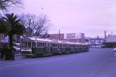
Photograph - Digital image Set of 7, Tony Smith, 19/09/1971 12:00:00 AM
Yields information about Ballarat Tramways and trams prior to the closure of the tramway system.Set of 7 digital images of Ballarat trams prior to closure, scanned from original slides by Tony Smith, 1971 prior to closure of the system. This set of slides appears to be the last day of operations - 19/9/1971 .1 - Four bogie trams parked in city loop with Woolworth's Big W and Dickins in the background. Not well focused. first tram 37 - see Reg Item 6158.6. .2 - 42 at Sturt and Lydiard St, north side, night photo with crew standing by the tram stop sign. Has the post office in the background. .3 - bogie tram at the south side, night photo, has the Commonwealth Bank in the background. .4 - 39 (at the rear of the four bogie trams parked in the City loop), night photo, looking west. .5 - 42 at Sebastopol terminus with the Royal Mail Hotel in the background - night photo. .6 - bogie tram and 39 parked in the city loop - two have now departed. Has Dickins, Gear Chemist and Edments Hartleys stores in the background. .7 - 34 at Sturt and Lydiard St north side.trams, tramways, closure, night photo, city loop, post office, tram 37, tram 42, tram 39, tram 34 -
 Ballarat Tramway Museum
Photograph - Digital image, Wal Jack, late 1930's
Yields information SEC 3rd 22, one of the ex Adelaide tramcars and the streetscape late 1930's. at the City tram terminus.Digital image from the Wal Jack Ballarat Album of No. 22 at the City terminus, south side, with the Post Office in background. Tram has the destination of Gardens via Sturt St West. Not dated, late 1930s. Note very similar image to Reg item 1373. See image i2 for rear of photograph. See Reg Item 1373 for a poor print and Reg Item 7540 for the original negative.on rear of photo in ink, "Ballarat Tramways 3rd No. 22 ex Adelaide 92 / smashed up July 1944 tram" and in bottom right corner "W. Jack"trams, tramways, sturt st -
 Ballarat Tramway Museum
Photograph - Black & White Photograph/s, c1927
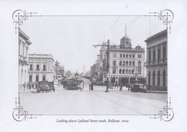
Yields information about Sturt and the streetscape with a horse tram outside St Andrews Kirk with two small boys playing.Black and white historic photograph downloaded from a picture resource website within a decorative frame. Printed with an inkjet printer. Titled "Looking down Lydiard Street south, Ballarat. circa:" shows an ESCo tram turning from Lydiard St north into Sturt St with many parked motor vehicles and pedestrians. Has the Post Office, Craigs Hotel, Commonwealth Bank, National Mutual Building and the Bank of Australasia in the photograph. One centre pole in the photograph. Photo c1927 Original photo from a postcard?trams, tramways, lydiard st north, poles, post office, esco, tram 20 -
 Bendigo Historical Society Inc.
Document - JOHN JONES COLLECTION: BACK TO MANDURANG SOUVENIR 1938
Photocopies and original of 'Back to Mandurang' Souvenir. Celebration 1938. Contains the history of Mandurang and many of the local residents, the industries and agricultural pursuits. Names mentioned are: Mrs Thomas, Les Nankervis, Geo McGuire, Pinche, Mr Coghill, Mr Fenton, Atkinson's Station, John T Deravin, Wine Hall, Church, Kerr's Hotel, Tannery, Mr Panton, John Billman, Sheepwash Creek, Emu Creek, Port Phillip District (Victoria), Mr Charlesworth, Sam Snowden, Mr Grant, Grant's Land Act, Mr Montgomery, Mr McEncroe, Mr Wyeland, John Smith, Mr Adams, Geo Kofoed, Monti, Mr Ewing, Wm Ewing, Geo Green, Jim Green, Green Bros, Wm Keating, Mandurang Hotel, J B Loridan, Mr Lansell, 'General Grant', August Heine, Mr Myers, Mr Barth, Phylloxeria, Mr Jones, Mr McGuire, James Hargreaves, Mr Bounty, E Huillier, Sam Martin, Mr Oldworth, Dr Backhaus, Andrew Monti, W Wenwright, Mr Munroe, Mr Eldridge, Wm Wright, W Thomas Lowe, Taylor, Sam Lowe, George Lowe, Wm Hargreaves, Albert E Pearce, Piccaninny Creek, G Sherriff, Mr Stein, Albert Stein, John Theodore Deravin, Robins, Phylloxera vastrix, Mr Grosse, Board of Health, Chateau Dore, House of Assembly, Dr Hugh Deravin, Mrs Deravin, John Adolphus Deravin, Education Department, Bendigo High School, St Andrew's College, Stock Exchange, Relief Funds, L Dungey, Mr Crawford, A W McCauley, Schillerio, Cleghorn, Goudge and Sibley, Sibley and Lambert, R H S Abbott, Protestant Church, Miss E Wright, W Stephenson, Geo Lowe, J Hargreaves, Theo Deravin, Wm Pearce, Mrs A Deravin, St John's Roman Catholic Church, Father O'Connell, Father McKnab, Post Office, I Witworth, W Casey, Franz Steilow, Geo Billman, R Brennan, F Osborne, Mr Webster, Wm Hughes, Mr Raymond, One Tree Hill, Jerry Ryan, Bendigo City, Shire of Strathfieldsaye. Original copies are very dilapidated and pages 6, 7, and 8 are missing. (In 5 pockets).ephemera, mementoes, back to mandurang, john jones collection - back to mandurang souvenir 1938, mrs thomas, les nankervis, geo mcguire, pinche, mr coghill, mr fenton, atkinson's station, john t deravin, wine hall, church, kerr's hotel, tannery, mr panton, john billman, sheepwash creek, emu creek, port phillip district (victoria), mr charlesworth, sam snowden, mr grant, grant's land act, mr montgomery, mr mcencroe, mr wyeland, john smith, mr adams, geo kofoed, monti, mr ewing, wm ewing, geo green, jim green, green bros, wm keating, mandurang hotel, j b loridan, mr lansell, 'general grant', august heine, mr myers, mr barth, phylloxeria, mr jones, mr mcguire, james hargreaves, mr bounty, e huillier, sam martin, mr oldworth, dr backhaus, andrew monti, w wenwright, mr munroe, mr eldridge, wm wright, w thomas lowe, taylor, sam lowe, george lowe, wm hargreaves, albert e pearce, piccaninny creek, g sherriff, mr stein, albert stein, john theodore deravin, robins, phtlloxera vastrix, mr grosse, board of health, chateau dore, house of assembly, dr hugh deravin, mrs deravin, john adolphus deravin, education department, bendigo high school, st andrew's college, stock exchange, relief funds, l dungey, mr crawford, a w mccauley, schillerio, cleghorn, goudge and sibley, sibley and lambert, r h s abbott, protestant church, miss e wright, w stephenson, geo lowe, j hargreaves, theo deravin, wm peatce, mrs a deravin, st john's roman catholic church, father o'connell, father mcknab, post office, i witworth, w casey, franz steilow, geo billman, r brennan, f osborne, mr webster, wm hughes, mr raymond, one tree hill, jerry ryan, bendigo city, shire of strathfieldsaye -
 Bendigo Historical Society Inc.
Book - CENTRAL DEBORAH MINE CORRESPONDENCE RE PLANT DEVELOPMENT PART 2
Black folder containing photocopied documents pertaining to the setting up and running of the Central Deborah Mine, Bendigo. 1939 - 1948. Original copies held in McColl,Rankin & Stanistreet Collection. Application for Permit. Ministry of Post War Reconstruction. War Organisation of Industry. Quotes, Tenders. Hume & Iser. T.J Jorgensen. Electricity Supply Department. Saunders & Ross. District Telephone Office. R Toma. Stock Exchange. Building Site Plan. Abbott Supply Co. F.W. Milne & Son. The Golden City Agricultural Implements. Department of Labour and National Service.Miller & Co. Thompson Engineering and Pipe Co. Gold Boring and Prospecting. Costs. J.l. Howard. A.J. William Electrical Instruments.bendigo, mining, central deborah gold mine -
 Bendigo Historical Society Inc.
Photograph - Pall Mall shops
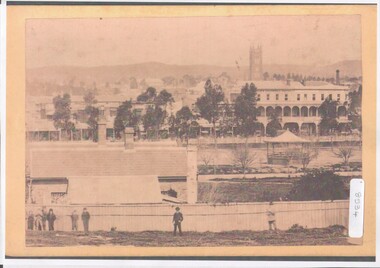
BHS CollectionA4 copy of original photograph. Pall Mall shops viewed from Government Camp, prior to 1870 (when Post Office and Court House were erected). View shows the Shamrock Hotel and the Royal Exchange Hotel with linked verandahs, the bell tower of St Paul's Anglican Church; and band stand (on the site of Post Office) beyond the creek. In the foreground part of the Government Offices with eight men shown on fence line.bendigo buildings, early buildings in bendigo late 1800s -
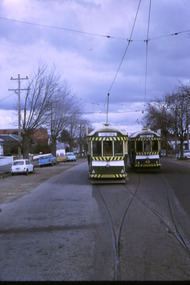
 Ballarat Tramway Museum
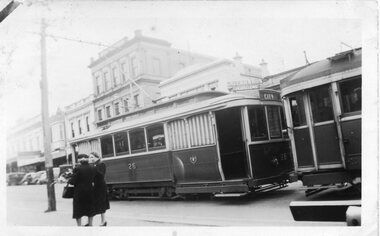
Photograph - Black and White - 26 at City in Sturt Street late 1940s to 1950s
Photograph shows Ballarat tram 26 parked behind a bogie car at the City terminus, in Sturt St at Lydiard St. Alongside there are two ladies talking to each other one holding a sheaf of flowers. In the background is the SEC City Office and Alan Bros Jewellers.Yields information about tram operations post the second world war.Black and White Photograph - 26 at City in Sturt Street 1950s. Original and Copy Print.ballarat, sturt st, city terminus, tram 26, trams, tramcars, tramways -
 Buninyong & District Historical Society
Photograph - Original B/W Photograph, De Soza park, Warrenheip St., Buninyong, with poppet head, rotunda and Chilean Wheel sculpture
... park rotunda poppet head sculpture Chilean wheel post office ...De Soza park was developed as a public amenity from the early 1980s. The poppet head and Chilean wheel sculpture are representative of the gold mining origins of the town.The park, located centrally in Buninyong is of social and historic significance.Original B/W photograph of streetscape of De Soza park frontage to Warrenheip St., Buninyong, with poppet head, rotunda and Chilean Wheel sculpture, former post office in background. Large eucalypt tree present behind rotunda, large cypress tree to north of park.buninyong, de soza, park, rotunda, poppet head, sculpture, chilean wheel, post office, warrenheip st, streetscape -
 Buninyong & District Historical Society
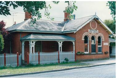
Photograph - Original Colour Photograph, Old Buninyong Post Office, taken 1982, 1982
... of Post Office building, 1980's. Buninyong Post Office building ...Record of Post Office building, 1980's.Colour photo, old Buninyong Post Office, Learmonth St. West, taken 1982.buninyong, post office, building, learmonth st. -
 Buninyong & District Historical Society
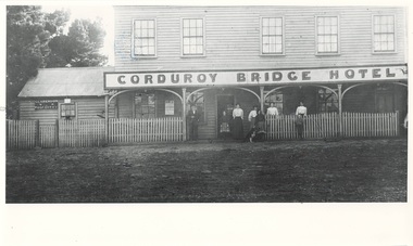
Photograph - Photograph of Original Photograph, Corduroy Bridge Hotel and Post Office, 1906, 1988
Building historyB/W photo of original photo of Corduroy Bridge Hotel, High St. Clarendon, circa 1906, shows Clarendon Post Office and members of Brown family.corduroy bridge hotel, clarendon, high street, clarendon post office -
 Buninyong & District Historical Society
Photograph - Original Photograph, Clive Brooks, Old Buninyong Post Office (1874), Learmonth St. Buninyong, 9 Nov. 1991
detail of historic buildingColour Photograph, Old Buninyong Post Office (1874), Learmonth St. Buninyongbuninyong, church, presbyterian, uniting, learmonth st. -
 Kew Historical Society Inc
Plan, Melbourne & Metropolitan Board of Works : Borough of Kew : Detail Plan No.1582, 1904
The Melbourne and Metropolitan Board of Works (MMBW) plans were produced from the 1890s to the 1950s. They were crucial to the design and development of Melbourne's sewerage and drainage system. The plans, at a scale of 40 feet to 1 inch (1:480), provide a detailed historical record of Melbourne streetscapes and environmental features. Each plan covers one or two street blocks (roughly six streets), showing details of buildings, including garden layouts and ownership boundaries, and features such as laneways, drains, bridges, parks, municipal boundaries and other prominent landmarks as they existed at the time each plan was produced. (Source: State Library of Victoria)This plan forms part of a large group of MMBW plans and maps that was donated to the Society by the Mr Poulter, City Engineer of the City of Kew in 1989. Within this collection, thirty-five hand-coloured plans, backed with linen, are of statewide significance as they include annotations that provide details of construction materials used in buildings in the first decade of the 20th century as well as additional information about land ownership and usage. The copies in the Public Record Office Victoria and the State Library of Victoria are monochrome versions which do not denote building materials so that the maps in this collection are invaluable and unique tools for researchers and heritage consultants. A number of the plans are not held in the collection of the State Library of Victoria so they have the additional attribute of rarity.Original survey plan, issued by the MMBW to a contractor with responsibility for constructing sewers in the area identified on the plan within the Borough of Kew. The plan was at some stage hand-coloured, possibly by the contractor, but more likely by officers working in the Engineering Department of the Borough and later Town, then City of Kew. The hand-coloured sections of buildings on the plan were used to denote masonry or brick constructions (pink), weatherboard constructions (yellow), and public buildings (grey). Public buildings, coloured grey on the Plan 1582 include the police station and post office, churches and schools. The earliest church school, Common School No.356 was located at the rear of the Congregational Church in Peel Street. It was constructed in 1859. The first buildings of Kew Primary School No.1075 on the other side of Peel Street were constructed in 1871. The school in 1903 only occupied a small fraction of its current site. In 1903, where the rear playground is now located, were two weatherboard and one brick villa. Trinity Grammar School was founded in 1902 and opened in the Parish Hall at the rear of Holy Trinity Anglican Church. It was not to move to its current site until 1906. The outline of the building housing the Kew Fire Brigade in the centre of the north side of Walton Street is shown but not named on the plan. Further down Pakington Street stood the two-storey Italianate mansion ‘Overton’. The home of Stanford Chapman, it was to be featured in the Imperial Institute series of bromide photographs of Victoria, Vol. 1: Homes and scenery. It was later to become a boarding house before it was later demolished.melbourne and metropolitan board of works, detail plans, maps - borough of kew, mmbw 1582, cartography -
 Kew Historical Society Inc
Plan, Melbourne & Metropolitan Board of Works : Borough of Kew : Detail Plan No.1588, 1904
The Melbourne and Metropolitan Board of Works (MMBW) plans were produced from the 1890s to the 1950s. They were crucial to the design and development of Melbourne's sewerage and drainage system. The plans, at a scale of 40 feet to 1 inch (1:480), provide a detailed historical record of Melbourne streetscapes and environmental features. Each plan covers one or two street blocks (roughly six streets), showing details of buildings, including garden layouts and ownership boundaries, and features such as laneways, drains, bridges, parks, municipal boundaries and other prominent landmarks as they existed at the time each plan was produced. (Source: State Library of Victoria)This plan forms part of a large group of MMBW plans and maps that was donated to the Society by the Mr Poulter, City Engineer of the City of Kew in 1989. Within this collection, thirty-five hand-coloured plans, backed with linen, are of statewide significance as they include annotations that provide details of construction materials used in buildings in the first decade of the 20th century as well as additional information about land ownership and usage. The copies in the Public Record Office Victoria and the State Library of Victoria are monochrome versions which do not denote building materials so that the maps in this collection are invaluable and unique tools for researchers and heritage consultants. A number of the plans are not held in the collection of the State Library of Victoria so they have the additional attribute of rarity.Original survey plan, issued by the MMBW to a contractor with responsibility for constructing sewers in the area identified on the plan within the Borough of Kew. The plan was at some stage hand-coloured, possibly by the contractor, but more likely by officers working in the Engineering Department of the Borough and later Town, then City of Kew. The hand-coloured sections of buildings on the plan were used to denote masonry or brick constructions (pink), weatherboard constructions (yellow), and public buildings (grey). This plan shows the original configuration of the Kew Post Office, Court House and Police Station, which had opened in 1888. This configuration was to essentially remain until the purchase of the Court House and Police Station by the City of Boroondara in 2007 and its subsequent renovation. Interestingly, the MMBW surveyors incorrectly labelled parts of the complex. In the triangle in front of the Post Office, before the erection of the Kew Cenotaph in 1925, was located a lawn and the Queen Victoria Jubilee Fountain. While many of the shops on the south side of High street had been constructed by 1903 a number of sites were still used as vegetable gardens. Further along High Street, on the corner of Charles Street, the Salvation Army Barracks can be seen on the plan. These Barracks predate the later Citadel and ‘Young People’s Hall’ that were opened in 1919. At 22 Charles Street can be seen the house of James Venn Morgan. Hailed as the ‘father of Kew’, Morgan arrived in Melbourne in 1840. He was first engaged as a bookmaker, but a fortunate venture on the goldfields enabled him to purchase land in Kew. He conducted a market garden and dairy in Kew for many years.melbourne and metropolitan board of works, detail plans, maps - borough of kew, mmbw 1588, cartography -
 Kew Historical Society Inc
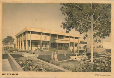
Drawing, AK Lines, Macfarlane & Marshall, Kew Civic Centre, c.1970
The Kew Civic Centre (A K Lines, MacFarlane & Marshall, 1972) was built next to the Kew Civic Hall (A C Leith & Bartlett, 1960) on the site of the former mansion Ordsall (later renamed South Esk). Whereas the entrance to the Civic Hall was positioned off Civic Drive, the main entrance to the Civic Centre faced Cotham Road, as shown in the undated perspective drawing of the proposed building. The Civic Hall was used for public functions and performances, while the Civic Centre was used for civic offices. It also contained the Council Chamber. The building opened in 1972, following the relocation of the councillors and council officers from the former Town Hall in Walpole Street (now a Woolworth's supermarket). Following the amalgamation of the former City of Kew into the City of Boroondara in 1994, the Civic Centre was sold to Trinity Grammar School. The exterior of the Centre has been modified by Trinity Grammar.A report for Heritage Victoria (date) describes how two architectural firms dominated the designs for new civic buildings in Victoria during the post war period. The report claims that: "An interesting sub-theme in the erection of post-war municipal offices in Victoria is that a considerable proportion were designed by the same three or four Melbourne-based architectural firms, who established themselves as the leading specialists in this type of work. The two most prolific firms in this regard were A K Lines, MacFarlane & Marshall, and A C Leith & Bartlett; both, in fact, had made names for themselves as designers of local government offices prior to the Second World War. Lines' office, for example had designed the Eltham Shire Offices in 1941, while Leith's firm had been responsible for the celebrated Heidelberg Town Hall in 1937). Both practices parleyed this early experience into a lucrative post-war career, designing numerous municipals offices well into the 1970s." (Survey of Post-War Built Heritage in Victoria, Built Heritage Pty Ltd, 2010.) The perspective drawing importantly captures the original design and function of the exterior of the building and its public entrance.Hand-coloured perspective sketch of the new Kew Civic Centre, completed in 1972 to designs by A K Lines, MacFarlane & Marshall; and located on the corner of Charles Street and Cotham Road, Kew. The sketch represents the front elevation of the building and its relation to the preexisting Kew Civic Hall at right. The three storey building features strong vertical concrete buttresses that extend across the three levels. KEW CIVIC CENTRE / A K LINES, MACFARLANE & MARSHALLkew civic centre, a.k. lines, macfarlane & marshall, architectural drawings, civic buildings -- kew (vic.), town hall -- kew (vic) -
 Kew Historical Society Inc
Archive (Sub-series) - Subject File, Development (Kew), 1958
Various partiesReference, Research, InformationSecondary Values (KHS Imposed Order)Subject file consisting largely of newspaper clippings/articles relating to houses in Kew. The earliest original newspaper article dates from 1923 and relates to housing shortages. The file contains some interesting Council records and correspondence relating to community action in response to development. These include the proposed lease of the Ground Floor of the Kew Civic Buildings as a postal delivery centre (1992), the development of flats in Studley Ward (1977), a proposed motel in Studley Park Road (1983)kew post office, heritage, planning and developmentkew post office, heritage, planning and development -
 Kew Historical Society Inc
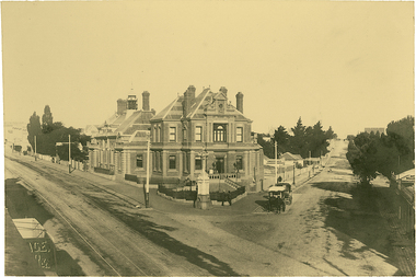
Photograph, J F C Farquhar, The Post Office, 1891
At the beginning of the 1890s, the Kew businessman and Town Councillor, Henry Kellett, commissioned J.F.C. Farquhar to photograph scenes of Kew. These scenes included panoramas as well as pastoral scenes. The resulting set of twelve photographs was assembled in an album, Kew Where We Live, from which customers could select images for purchase.The preamble to the album describes that the photographs used the ‘argentic bromide’ process, now more commonly known as the gelatine silver process. This form of dry plate photography allowed for the negatives to be kept for weeks before processing, hence its value in landscape photography. The resulting images were considered to be finely grained and everlasting. Evidence of the success of Henry Kellett’s venture can be seen today, in that some of the photographs are held in national collections.It is believed that the Kew Historical Society’s copy of the Kellett album is unique and that the photographs in the book were the first copies taken from the original plates. It is the first and most important series of images produced about Kew. The individual images have proved essential in identifying buildings and places of heritage value in the district.A panoramic photograph of the junction of High Street and Cotham Road. The photographer centres the point-of-view on the Kew Post Office and adjacent Court House. These were designed in the Queen Anne style by the Public Works Department's architect J Harvey and completed in 1888. The complex is important because it demonstrates a departure from the contemporaneously favoured High Victorian Classical to the Queen Anne style in the design of civic buildings. The earlier Jubilee Fountain in front of the Post Office was erected by the Kew Borough Council to commemorate the Golden Jubilee of Queen Victoria in 1887. It was created to a design of the architects Reed, Henderson and Smart. The fountain was later relocated to the Alexandra Gardens to make way for the Kew War Memorial. The tram tracks in High Street were used by the horse tram, which ran from the Victoria Street Bridge to the Boroondara General Cemetery. The tram was replaced by an electrified service in 1915.The Post Officekew post office, kew illustrated, kew where we live, photographic books, henry kellett -
 Kew Historical Society Inc
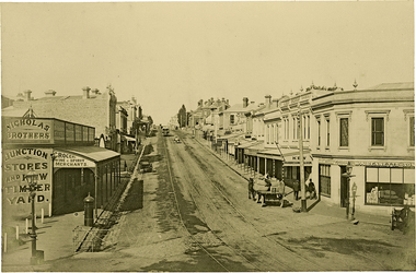
Photograph, J F C Farquhar, High Street, Kew, 1891
At the beginning of the 1890s, the Kew businessman and Town Councillor, Henry Kellett, commissioned J.F.C. Farquhar to photograph scenes of Kew. These scenes included panoramas as well as pastoral scenes. The resulting set of twelve photographs was assembled in an album, Kew Where We Live, from which customers could select images for purchase.The preamble to the album describes that the photographs used the ‘argentic bromide’ process, now more commonly known as the gelatine silver process. This form of dry plate photography allowed for the negatives to be kept for weeks before processing, hence its value in landscape photography. The resulting images were considered to be finely grained and everlasting. Evidence of the success of Henry Kellett’s venture can be seen today, in that some of the photographs are held in national collections.It is believed that the Kew Historical Society’s copy of the Kellett album is unique and that the photographs in the book were the first copies taken from the original plates. It is the first and most important series of images produced about Kew. The individual images have proved essential in identifying buildings and places of heritage value in the district.In 1891, High Street was the centre of commercial activity in the Borough of Kew. It was unpaved and edged with deep bluestone gutters, which were designed to channel the significant flow of storm water down the hill to and beyond the Junction. On either side of the entrance to the shopping strip are two cast iron gas lamps that provided the only public street lighting before the Post Office was reached. Most shops, including the Nicholas Brothers’ Junction Store featured cast iron verandas. Further up the hill, Dougherty’s Greyhound Hotel was by this stage a local institution. Apart from the horse-drawn tram, the main form of personal and commercial transport in this period remained the horse, horse and cart, or buggy.The panoramic view predates the widening of High Street in the 20th century, and thus includes the original alignment of buildings on the south side. These included Henry Kellett’s shop.High Street, Kewkew illustrated, kew where we live, photographic books, henry kellett, high street - kew (vic) -
 Kew Historical Society Inc
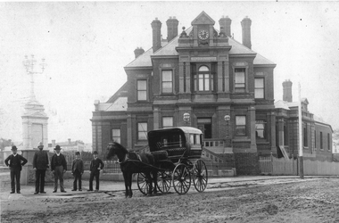
Photograph, Kew Post Office, c.1888
A copy of the earliest known photograph of the former Kew Post Office on the corner of Cotham Road and High Street, Kew. The Post Office was opened in 1888. The original architectural drawings are held at the Public Record Office Victoria.The photograph is significant as the earliest known image of this Heritage Victoria designated historic building.The Kew Post Office on the corner of High Street and Cotham Road, Kew. The photograph includes the Queen Victoria Jubilee fountain at left. The image predates the large fig tree planted on the corner and the later Kew War Memorial (1925). What are presumed to be government employees stand beside the horse and buggy. -
Kew Historical Society Inc
Print, Post Office and Police Court Kew, 1907-1915
The Kew Historical Society's postcard collection includes views of Kew, Melbourne and Greater Melbourne as well as those including overseas scenes sent or received from Europe or the Middle East. They date from the 1890s to the 2000s. These postcards may or may not include the name of the publisher or printer. A number of the cards were published as parts of popular series. A way of dating early postcards is to identify whether the reverse was divided by a central line which became the norm after 1902 in the United Kingdom. However, other postcards produced after this date do not always conform to this print layout.An enlargement of an original postcard in the collection, created for the purposes of exhibition, depicting the Kew Post Office and Court House (built 1888) on the corner of High Street and Cotham Road. In front of the Post Office is a large Moreton Bay Fig tree. The later Kew War Memorial (opened 1925) necessitated the removal of the tree and the relaocation of the Queen Victoria Jubilee Fountain. kew court house, kew post office -
 Kew Historical Society Inc
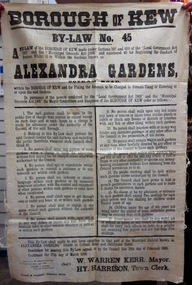
Document, Borough of Kew, Borough of Kew By-Law No.45 : Alexandra Gardens, 1908
The ‘Alexandra Gardens’ in Cotham Road were designed and laid out by George and Thomas Pockett. The Governor of Victoria officially opened them in 1908. A report of the opening stated that “…the gardens have been laid out in large sloping lawns, divided by wide graveled paths, and dotted with tastefully arranged flower beds, which are now bright with autumn bloom”. The massed beds of shrubs and flowers included beds of chrysanthemums, a specialty of George Pockett, the Garden’s first curator. A large rotunda was constructed in 1910 to mark the Jubilee of Kew. A plaque memorialising the contribution of George Pockett, was attached to the original rotunda after his death in 1922. By 1911, electric lighting was installed to allow the public to access the Gardens, and the concerts that were held within them on summer nights. The Gardens were later to include the Jubilee Fountain, moved from the front of the Kew Post Office in 1925. The Kew Council commissioned the substantial bluestone entrance gates in 1933.The Kew Historical Society is fortunate that the City Engineer, Mr Poulter, donated a number of items held by the City of Kew to the Society for safekeeping, rather than identifying them for destruction. The most significant items donated included old maps, including those issued by the Board of Works. Other items included photographs of public works undertaken by the Department. The By-laws are part of that donation and tell us lots about the social values of the period.The Mayor, Councillors and Burgesses of the Borough of Kew published By-Law No.45 in 1908 to regulate the “Conduct of Persons whilst at or Within the Gardens known as the Alexandra Gardens”. The By-Law also set a charge for “Persons Using or Entering in or upon the said Gardens”. The 17 by-laws included predictable prohibitions on expectorating, using indecent language, interfering with the floral displays, or indeed with the caretaker gardeners. Other acts prohibited included a warning that “Children under the age of ten years not being under the control of some competent person may be removed from said gardens”. The Alexandra Gardens were at one stage surrounded by a picket fence. This might explain the prohibition on climbing upon or getting through over or under any fence at or within the gardens. The financial penalty for breaching the By-Law was determined as “…not exceeding Ten pounds and not less than Five shillings”. This original copy of the By-Law was donated to the Kew Historical Society by the City of Kew.alexandra gardens (cotham road, kew), city of kew -
 Kew Historical Society Inc
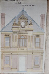
Slide - Architectural Drawing, Kew Public Offices, 1887
A civic campaign for new public offices developed in Kew in the 1880s. After much deliberation, the location chosen was the junction of Bulleen and Cotham Roads. The buildings were designed by George Watson and John Henry Harvey, architects within the Department of Public Works (Victoria). Building was commenced in 1887, and after one year, the buildings were opened. The Post Office was transferred to the new Commonwealth Government in 1901. The Police Station and Court House, sold by the Victorian Government to the City of Boroondara in 2007, are now a community cultural centre and performing arts venue.The buildings were listed on the Victorian Heritage Register Register (HO885) in 1991. They are historically and architecturally significant to the State Of Victoria because Watson and Harvey's designs exhibit diversity in integrating civil offices, they accommodate the apex of road junctions, and they demonstrate a departure from the contemporaneously favoured High Victorian Classical to the Queen Anne style in the design of civic buildings. 35mm colour transparency of an original plan by George Watson and John Henry Harvey, architects of the Department of Public Works (Victoria), in 1887 for New Public Offices at Kew. This plan was copied by the donor from an original held at the Commonwealth Archives in Brighton (Vic). The copy was made to illustrate a report that the donor made on ‘The functional planning design, building materials and construction methods of the Kew Post Office’ as part of course work at RMIT.THE PUBLIC OFFICES, KEW / SCALE 2 FEET TO ONE INCHkew court house, kew police station, architectural drawings, khs - slides, new public offices — kew (vic.), architecture — queen anne style -
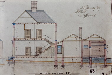 Kew Historical Society Inc
Slide - Architectural Drawing, Kew Public Offices, 1887
A civic campaign for new public offices developed in Kew in the 1880s. After much deliberation, the location chosen was the junction of Bulleen and Cotham Roads. The buildings were designed by George Watson and John Henry Harvey, architects within the Department of Public Works (Victoria). Building was commenced in 1887, and after one year, the buildings were opened. The Post Office was transferred to the new Commonwealth Government in 1901. The Police Station and Court House, sold by the Victorian Government to the City of Boroondara in 2007, are now a community cultural centre and performing arts venue.The buildings were listed on the Victorian Heritage Register Register (HO885) in 1991. They are historically and architecturally significant to the State Of Victoria because Watson and Harvey's designs exhibit diversity in integrating civil offices, they accommodate the apex of road junctions, and they demonstrate a departure from the contemporaneously favoured High Victorian Classical to the Queen Anne style in the design of civic buildings. 35mm colour transparency of an original plan by George Watson and John Henry Harvey, architects of the Department of Public Works (Victoria), in 1887 for New Public Offices at Kew. This plan was copied by the donor from an original held at the Commonwealth Archives in Brighton (Vic). The copy was made to illustrate a report that the donor made on ‘The functional planning design, building materials and construction methods of the Kew Post Office’ as part of course work at RMIT.SECTION ON LINE E-Fkew court house, kew police station, kew post office, architectural drawings, khs - slides, new public offices — kew (vic.), architecture — queen anne style -
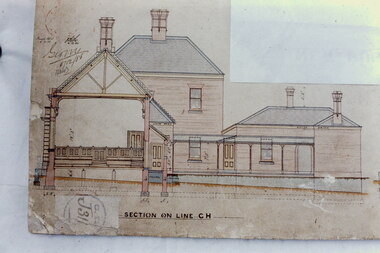 Kew Historical Society Inc
Slide - Architectural Drawing, Kew Public Offices, 1887
A civic campaign for new public offices developed in Kew in the 1880s. After much deliberation, the location chosen was the junction of Bulleen and Cotham Roads. The buildings were designed by George Watson and John Henry Harvey, architects within the Department of Public Works (Victoria). Building was commenced in 1887, and after one year, the buildings were opened. The Post Office was transferred to the new Commonwealth Government in 1901. The Police Station and Court House, sold by the Victorian Government to the City of Boroondara in 2007, are now a community cultural centre and performing arts venue.The buildings were listed on the Victorian Heritage Register Register (HO885) in 1991. They are historically and architecturally significant to the State Of Victoria because Watson and Harvey's designs exhibit diversity in integrating civil offices, they accommodate the apex of road junctions, and they demonstrate a departure from the contemporaneously favoured High Victorian Classical to the Queen Anne style in the design of civic buildings. 35mm colour transparency of an original plan by George Watson and John Henry Harvey, architects of the Department of Public Works (Victoria), in 1887 for New Public Offices at Kew. This plan was copied by the donor from an original held at the Commonwealth Archives in Brighton (Vic). The copy was made to illustrate a report that the donor made on ‘The functional planning design, building materials and construction methods of the Kew Post Office’ as part of course work at RMIT.SECTION ON LINE C-Hkew court house, kew police station, kew post office, architectural drawings, khs - slides, new public offices — kew (vic.), architecture — queen anne style