Showing 6936 items matching " street views"
-
 Surrey Hills Historical Society Collection
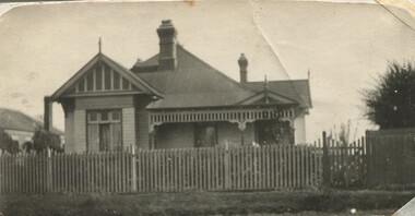
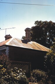
Photograph, 10 Pembroke Street, Surrey Hills
... Original sepia photograph of the street view... of the street view of a weatherboard in the Queen Anne style ...William Valentine Hill (1854-1940) journalist, was the owner of 'Eignbrook',10 Pembroke Street from 1904. His wife was Annie Boak (1865-1943); they were married in 1885. William Hill (Bill) Dempsey was his grandson. His mother Laura Constance Hill married Herbert T Dempsey in 1925.Original sepia photograph of the street view of a weatherboard in the Queen Anne style with a steep pitched iron roof; house is fronted by a picket fence. There are 2 copies of this original photo; the better copy has been scanned. The second copy is slightly mottled and the edges left and right have been cropped so that the adjacent house is not seen. Back of photo 1 is inscribed “10 Pembroke St. Donor W Dempsey”. Photo 2 has inscribed on back "Hills home, 10 Pembroke St, Surrey Hills. Donor W Dempsey" Card has written underneath the photo, “10 Pembroke St”pembroke street, hills family, 'eignbrook', house names, surrey hills, (mr) william valentine hill, journalist, (mrs) annie hill, (miss) annie boak, queen anne style -
 Canterbury History Group
Photograph - Street view of the laneway between shop nos 121 and 119 Maling Road, Jan Pigot, 27/03/1993 12:00:00 AM
... Street view of the laneway between shop nos 121 and 119...Coloured photograph of a street view of the laneway between... Coloured photograph of a street view of the laneway between shop ...Coloured photograph of a street view of the laneway between shop nos 121 and 119 Maling Road. The elevated railway can be seen in the distancecanterbury, maling road, shops, laneways, railway stations -
Canterbury History Group
Photograph - Street view of the Telephone Exchange next to Canterbury Post Office from Maling Road, Stuart Warmington, 1995
... Street view of the Telephone Exchange next to Canterbury...Coloured photograph of Street view of the Telephone... of Street view of the Telephone Exchange next to Canterbury Post ...Coloured photograph of Street view of the Telephone Exchange next to Canterbury Post Office from Maling Road. Laneway visible between the 2 premises.canterbury, maling road, shops, laneways -
Canterbury History Group
Photograph - Bryson Street view of the back of shop No. 92 Maling Road, Jan Pigot, 1994
... Bryson Street view of the back of shop No. 92 Maling Road...Coloured photograph of the Bryson Street view of the back... Buckley Family Coloured photograph of the Bryson Street view ...Coloured photograph of the Bryson Street view of the back of Buckley's Supermarket at shop No. 92 Maling Road. This is also the corner of the building named The Block 1907.canterbury, maling road, shops, bryson street, the block, buckley family -
Canterbury History Group
Photograph - Bryson Street view of the back of shop No. 92 Maling Road, Jan Pigot, 1994
... Bryson Street view of the back of shop No. 92 Maling Road...Coloured photograph of the Bryson Street view of the back... Buckley Family Coloured photograph of the Bryson Street view ...Coloured photograph of the Bryson Street view of the back of Road and Bryson Street depicting Buckley's Supermarket. This is also the corner of the building named The Block 1907.canterbury, maling road, shops, the block, bryson street, buckley family -
Canterbury History Group
Photograph - Bryson Street view of the back of shop No. 92 Maling Road, Jan Pigot, 1994
... Bryson Street view of the back of shop No. 92 Maling Road...Coloured photograph of the Bryson Street view of the back... The Block Coloured photograph of the Bryson Street view of the back ...Coloured photograph of the Bryson Street view of the back of Buckley's supermarket at shop No. 92 Maling Road. This is also the corner of the building named The Block 1907.canterbury, maling road, shops, bryson street, buckely family, the block -
Canterbury History Group
Photograph - Street view of the position of the bronze plaque in the foot path for the former State Savings Bank of Victoria at 121 Maling Road, Canterbury, Jan Pigot, 2004
... Street view of the position of the bronze plaque in the...Coloured photograph of the street view of the position... photograph of the street view of the position of the bronze plaque ...Coloured photograph of the street view of the position of the bronze plaque in the foot path for the former State Savings Bank of Victoria at 121 Maling Road, Canterbury.canterbury, maling road, shops, signs, plaques -
 Bendigo Historical Society Inc.
Photograph - CASTLEMAINE GAS COMPANY COLLECTION: PHOTO HIGH STREET
... High Street at Mitchell and View Street Intersection - Date... ORGANISATION Industry gas and fuel High Street at Mitchell and View ...High Street at Mitchell and View Street Intersection - Date Unknownorganisation, industry, gas and fuel -
 Eltham District Historical Society Inc
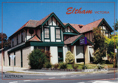
Postcard, McKenzie Photography, Eltham Hotel, Eltham, Victoria, Australia, 2015c
... viewed from Main Road looking towards Pitt Street. Mel: 21 J7... of Eltham Hotel, cnr Main Road and Pitt Street viewed from Main Road ...Postcard of Eltham Hotel, cnr Main Road and Pitt Street viewed from Main Road looking towards Pitt Street. Mel: 21 J7eltham-hotel, main-road, pitt-street, eltham -
 Glen Eira Historical Society
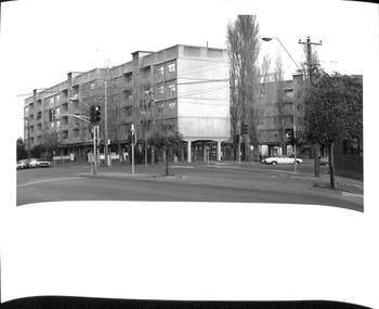
Album - Album page, Hawthorn Road, Circa 1972
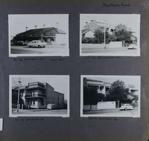
... of street views of two sets of properties on Hawthorn Road... with four landscape photographs of street views of two sets ...This photograph is part of the Caulfield Historical Album 1972. This album was created in approximately 1972 as part of a project by the Caulfield Historical Society to assist in identifying buildings worthy of preservation. The album is related to a Survey the Caulfield Historical Society developed in collaboration with the National Trust of Australia (Victoria) and Caulfield City Council to identify historic buildings within the City of Caulfield that warranted the protection of a National Trust Classification. Principal photographer thought to be Trevor Hart, member of Caulfield Historical Society. Most photographs were taken between 1966-1972 with a small number of photographs being older and from unknown sources. All photographs are black and white except where stated, with 386 photographs over 198 pages. 23-29 Hawthorn Road Caulfield North are contributory buildings to HO14 Caulfield North and environs, Caulfield North - Heritage Precinct in the City of Glen Eira.Page 82 of Photograph Album with four landscape photographs of street views of two sets of properties on Hawthorn Road. Addresses are handwritten underneath each property.Handwritten: Hawthorn Road [top right] / 28-34 HAWTHORN ROAD 3 Sep 1972 [under top left photo] / 23-29 HAWTHORN ROAD [under top right photo] / 23-29 HAWTHORN ROAD 3 Sep [under bottom left photo] / 23-29 HAWTHORN ROAD [under bottom right photo] / 82 [bottom right] trevor hart, caulfield, hawthorn road, victorian, cars, terrace houses, cottages, streetscapes, caulfield north -
 Port Melbourne Historical & Preservation Society
Photograph - Raglan Street Housing Commission Flats viewed from Ingles Street, Andrew U'REN, C. 1970s - 1980s
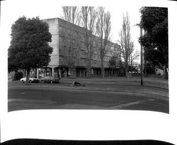
... Commission flats at the corner of Ingles and Crockford Streets viewed... Streets viewed from Ingles Street. Large white border ...From a box of photographs in Nancy U'REN's papers used during research for her thesis, The Early Growth and Development of Sandridge (1976) and/or her book with Noel TURNBULL, A History of Port Melbourne (1983). The print was probably made by her son, Andrew U'REN, and he may have also taken the photograph.Black and white photograph of the blocks of Housing Commission flats at the corner of Ingles and Crockford Streets viewed from Ingles Street. Large white border at the bottom.A star in blue ink at the bottom left corner and details of photographic paper type and exposure details on the reverse.built environment - public housing, ingles street, crockford street, built environment - domestic, raglan street housing commission of victoria flats, nancy u'ren nee morris -
 Bendigo Historical Society Inc.
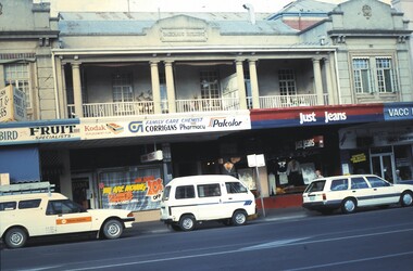
Slide - ALLAN BUDGE COLLECTION: SLIDE MITCHELL STREET, 1988
... , Mitchell Street. View of Corrigan's Chemist shop (in the Backhaus... Inc. History House 11 Mackenzie Street Bendigo goldfields ...Slide, ALLAN BUDGE COLLECTION, Polychrome Brickwork, Mitchell Street. View of Corrigan's Chemist shop (in the Backhaus Building) just after its closure in 1988.house, public, allan budge collection, allan budge collection -
 Uniting Church Archives - Synod of Victoria
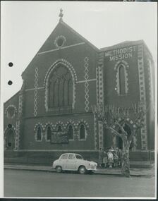
Photograph, undated
... Church. The image is a street view of a group of children... Church. The image is a street view of a group of children ...The Gipps Street Wesleyan Methodist Church of 1874 and the adjoining school hall, were built in the Collingwood Flat area - one of the municipality's poorest areas. In 1903, the Collingwood Methodist Mission was established with its headquarters in the Gipps Street Church. Six Methodist Missions were created in inner Melbourne. Three churches were operated by the Collingwood Mission. They were: Sackville Street Collingwood, Elizabeth Street, North Richmond (demolished), and Gipps Street Collingwood (demolished). The Mission operated until approximately 1930.B & W exterior view of the Gipps St. Collingwood Methodist Church. The image is a street view of a group of children and an adult standing in front of the brick church.gipps st. methodist church, les gorrie, collingwood mission -
 Surrey Hills Historical Society Collection
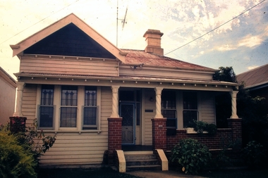
Photograph, 11 York Street, Mont Albert, 1974 (1), 1974
... Black & white photo of the street view of 11 York Street...: "No 11 York St / 1974" Black & white photo of the street view ...This is the home of Ernest Lance Young and Beryl Mair and the childhood home of their children Barbara, Ken and Laurie. Lance was born 24 March 1915 in Surrey Hills, the son of Ernest Augustus Young and Ruby Nichell Whitty. He married Beryl Mair in 1939 and died on 5 October 1999 at Mont Albert. Electoral rolls list him as a manufacturer. His address after marriage was 11 York Street, Mont Albert. He is buried in Box Hill Cemetery (M-*-0867) along with his father. He served in WW2 (Service Number - VX104733 enlisting at St Kilda) and after returning took over his father's business. The Mair family were resident in Barton Street for several generations. Beryl's father Dave Mair was a keen sportsman and founder of the Kangaroo Social Club of cricketers. This is part of a large collection relating to the Mair, Deakin and Young families. Black & white photo of the street view of 11 York Street, Mont Albert. The house is heavily screened by a mature garden with several large trees or shrubs.In red biro on rear: "No 11 York St / 1974" ken young, barbara young, laurie young, laurie newton, beryl mair, ernest lance young, lance young, york street, mont albert -
Canterbury History Group
Photograph - Street view of the Bryson Road side of shop No. 92 Maling Road, Jan Pigot, 1994
... Street view of the Bryson Road side of shop No. 92 Maling...Coloured photograph of the street view of the Bryson Road... The Block Coloured photograph of the street view of the Bryson Road ...Coloured photograph of the street view of the Bryson Road side of Buckley's Supermarket, shop No. 92 Maling Road. This is also the corner of the building named The Block 1907.canterbury, maling road, shops, bryson street, buckley family, the block -
 The Beechworth Burke Museum
Photograph, 1876
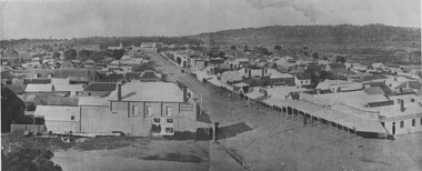
... Obverse: NO INSCRIPTION Reverse: 84-215-1 Panorama Streets... Panorama Streets Beechworth 1876 Town views Black and white ...Taken in Beechworth 1876, this panoramic photograph depicts Ford Street looking North. Black and white rectangular photograph printed on gloss photographic paper. Obverse: NO INSCRIPTION Reverse: 84-215-1 Panorama Streets Beechworth 1876 Town viewsbeechworth, ford street, town views, panorama -
 The Beechworth Burke Museum
Photograph - Postcard
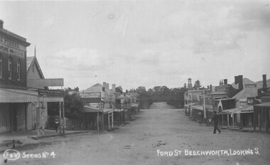
... street town views Obverse: F & V Series No 4 FORD ST BEECHWORTH ...Taken in Beechworth, this photograph was taken from from close to Church Street intersection with Ford.Black and white rectangular post card.Obverse: F & V Series No 4 FORD ST BEECHWORTH, LOOKING.S Reverse: 1997.2753 AO2753 POST CARDbeechworth, ford street, town views -
 Port Melbourne Historical & Preservation Society
Photograph - Raglan Street Housing Commission Flats viewed from Crockford Street, Andrew U'REN, C. 1970s - 1980s
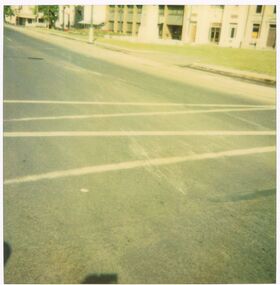
... Commission flats at the corner of Ingles and Crockford Streets viewed... at the corner of Ingles and Crockford Streets viewed from Crockford ...From a box of photographs in Nancy U'REN's papers used during research for her thesis, The Early Growth and Development of Sandridge (1976) and/or her book with Noel TURNBULL, A History of Port Melbourne (1983). The print was probably made by her son, Andrew U'REN, and he may have also taken the photograph. The photograph includes two people on the median strip. It is unclear what they are doing or what has happened just before the photograph was taken. One person is kneeling closely over the other who appears to be lying on their back.Black and white photograph of the Raglan Street Housing Commission flats at the corner of Ingles and Crockford Streets viewed from Crockford Street. Large white border at the bottom.Details of photographic paper type and exposure details in blue ink on the reverse.built environment - public housing, ingles street, crockford street, raglan street housing commission of victoria flats, built environment - domestic, nancy u'ren nee morris -
 Bendigo Historical Society Inc.
Photograph - CASTLEMAINE GAS COMPANY COLLECTION: PHOTO HIGH STREET
... High Street looking toward little View Street - Date... little View Street - Date Unknown Photograph CASTLEMAINE GAS ...High Street looking toward little View Street - Date UnknownPolaroidorganisation, industry, gas and fuel -
 Bendigo Historical Society Inc.
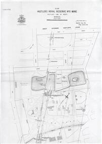
Plan - Hustler's Royal Reserve No. 2 Mine, April, 2014
... , bowling green, Jail (sic) Barnard Street, View Street and Park... (sic) Barnard Street, View Street and Park Road. Whitelaw plan ...One page plan (photocopy) of Hustler's Royal Reserve No. 2 Mine (Park Shaft) showing mine location, dams, tennis courts, bowling green, Jail (sic) Barnard Street, View Street and Park Road. Whitelaw plan, 1913.goldmining, accident, quartz, mining, hustler's royal reserve no. 2 mine, park shaft, hustler's line of reef, gaol, -
 Bendigo Historical Society Inc.
Slide - No 104 Garsed Street Bendigo
... - Could not find on Google Street View; believed demolished... Branch - Could not find on Google Street View; believed ...No 104 Garsed Street Bendigo - Late Edwardian c1925-1930 - Slide from the National Trust of Victoria, Bendigo Branch - Could not find on Google Street View; believed demolishedhistory, bendigo, national trust collection bendigo, 104 garsed street bendigo -
 Surrey Hills Historical Society Collection
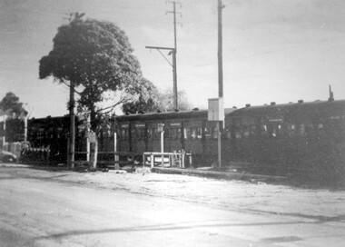
Photograph - Black and White Photograph, Last train to cross the grade level crossing at Elgar Road
... A black and white photo taken from street view of a swing... and white photo taken from street view of a swing door train ...The last swing door train was withdrawn from service in 1973. The third track on this line was commissioned in 1971. The overpass bridge was built at this time. These dates place the photo as pre-1971. More research needed.A black and white photo taken from street view of a swing door train crossing a roadway with a simple boom gate barrier. The bonnet of a car can be seen at the LHS of the photo.elgar road, trains, alfred noack, boom gates, swing door trains -
 Surrey Hills Historical Society Collection
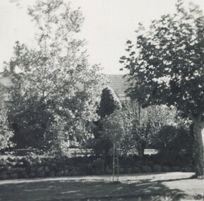
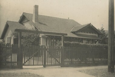
Photograph, Sister Ann Elizabeth Dowsley's home in Elgar Road, Box Hill, c1939
... Black & white photo of the street view of a Californian.... Black & white photo of the street view of a Californian bungalow ...This was the home of Sister Ann Elizabeth Dowsley, daughter of Thomas Dowsley and Mary McKay. She was born in St Arnaud in 1887. She enlisted on 22 August 1916. As a AANS Matron in WW1 she served in India. She was awarded a Royal Red Cross award for conspicuous services. She did not marry. She died in December 1960 at Caulfield. There is a photo of her in Punch, Thursday 31 August, 1916, p 21. REF: Laurie Newton - Ernest Lance Young and Beryl (nee Mair) bought the house from Sister Dowsley for £895 on their marriage in 1939 but sold it when Lance was sent to Darwin during his war service. Beryl purchased 11 York Street in later war years. This property was also significant for Ernest Lance Young and Beryl Mair. It may have been the childhood home of their children Barbara and Ken, but Laurie was probably born after they moved to York Street. Lance was born 24 March 1915 in Surrey Hills, the son of Ernest Augustus Young and Ruby Nichell Whitby. He married Beryl Mair in 1939 and died on 5 October 1999 at Mont Albert. Electoral rolls list him as a manufacturer. He is buried in Box Hill Cemetery (M-*-0867) along with his father. He served in WW2 (Service Number - VX104733 enlisting at St Kilda) and after returning took over his father's business. The Mair family were resident in Barton Street for several generations. Beryl's father Dave Mair was a keen sportsman and founder of the Kangaroo Social Club of cricketers. This is part of a large collection relating to the Mair, Deakin and Young families. Black & white photo of the street view of a Californian bungalow home set behind a picket fence and hedge. The house appears to be weatherboard and render with a terracotta tile roof and a simple chimney.In blue biro on rear: "Our first home", "Sister Dowsleys home at / Elgar Rd B Hill"; "YOUNG" In lead pencil on rear: " 3 (pound symbol) 895" Photographic processing stamps "14" and (?) "GRANVILLE PRINT" within a triangle. ann elizabeth dowsley, world war 1, nurse, elgar road, ernest lance young, beryl young, beryl mair -
Canterbury History Group
Photograph - Street view of the corner of Maling Road and Bryson Street depicting the shop No. 92. Maling Road, Jan Pigot, 1994
... Street view of the corner of Maling Road and Bryson Street...Coloured photograph of the street view of the corner... The Block Coloured photograph of the street view of the corner ...Coloured photograph of the street view of the corner of Maling Road and Bryson Street depicting Buckley's Supermarket at shop No. 92. Maling Road This is also the corner of the building named The Block 1907.canterbury, maling road, shops, bryson street, buckley family, the block -
 Bendigo Historical Society Inc.
Slide - ALLAN BUDGE COLLECTION: SLIDE COBDEN STREEET HOUSE, 1988
... Slide, ALLAN BUDGE COLLECTION, General Views, Cobden Street..., ALLAN BUDGE COLLECTION, General Views, Cobden Street, General ...Slide, ALLAN BUDGE COLLECTION, General Views, Cobden Street, General Views. A simple dwelling with fine chimney detailing.house, public, allan budge collection, allan budge collection -
 City of Ballarat Libraries
Postcard - Card Box Photographs, Eureka Reserve, Ballarat circa 1900
... Located on Stawell Street. View of the lake.... Ballarat East goldfields Located on Stawell Street. View ...Located on Stawell Street. View of the lake.eureka reserve, stawell street, garden, public, eureka gardens -
 City of Kingston
Photograph - Black and white, c. 1960
... at McKinnon railway station. The image also affords a street view... at McKinnon railway station. The image also affords a street view ...This image is part of a larger collection of images from the Public Transport Corporation displaying train stations and streetscapes in what is now the City of Kingston.Black and white photograph of crossed level crossing gates at McKinnon railway station. The image also affords a street view which includes the shopping strip where advertising signs abound.Stamped in blue ink on reverse: COPYRIGHT / Public Transport Corporation / For re-ordering photographs / Please quote negative No PR4764 / Enquiries C/- PTC Photographic Unit / Telephone switchboard 619 111mckinnon, railway station, streetscape, shopping strip, suburbs -
 City of Greater Bendigo - Civic Collection
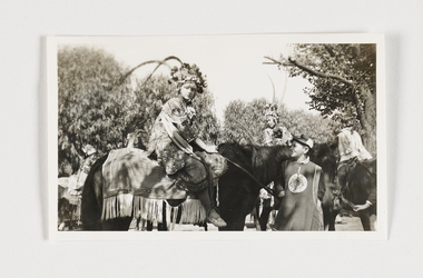
Photograph - Three photographs : Bendigo Easter Fair, 27 April, 1938
... of one of the horses. 0322.2; Exterior; street view... of the horses. 0322.2; Exterior; street view with children in foreground ...The Bendigo Easter Fair was established in 1871 to fundraise for the Bendigo Hospital and the Bendigo Benevolent Asylum. Donated by the Sadner family who were associated with the Bendigo Hospital, these family snap shots capture the regalia and atmosphere that the Chinese community bring to this community event. Set of three black and white photographs. All photograph are taken on the streets of Bendigo during the 1938 Easter fair and parade. 0322.1; Exterior; Three people on horses in traditional chinese costume. Person in the foreground is holding the reins of one of the horses. 0322.2; Exterior; street view with children in foreground and a line of people in costume holding chinese banners. 0322.3 Exterior, street view from balcony of the two cars with people lined up on either side.Verso; 0322.1, 0322.2 27 April, 1938. 0322.3 Handwritten; Late 1930's C/r Mitchell, Garsed Streets from Terminus Hotel Balcony.eugene and mollie sandner collection, bendigo hospital, eugene sandner, mollie sandner, mollie sibson, bendigo easter fair, mayor sandner, mayoress sandner, bendigo chinese dragon -
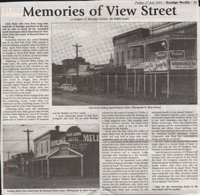 Bendigo Historical Society Inc.
Newspaper - JENNY FOLEY COLLECTION: MEMORIES OF VIEW STREEET
... describing the small businesses that flourished in View Street from... 2001. Memories of View Street - a snippet of Bendigo history ...Bendigo Weekly, Friday 27, July 2001. Memories of View Street - a snippet of Bendigo history, by Edith Lunn - An article describing the small businesses that flourished in View Street from the corner of Barnard Street to View point. The clip is in a folder.newspaper, bendigo, bendigo weekly -
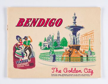 City of Greater Bendigo - Civic Collection
Souvenir - Booklet, City of Bendigo, Bendigo. The Golden City, 1951
... buildings, churches and street views. ... of civic buildings, churches and street views. Bendigo. The Golden ...Promotional publication to promote Bendigo and its year long Centenary Festival. Twenty four page illustrated full colour publication promoting Bendigo's Centenary Festival and calendar of events. Includes full and quarter page colour photographs of civic buildings, churches and street views. city of greater bendigo events, bendigo centenary, making a nation exhibition