Showing 543 items
matching vegetation
-
 Lakes Entrance Regional Historical Society (operating as Lakes Entrance History Centre & Museum)
Photograph, 1930c
This is the before photograph used in the 150 year Lakes Entrance 1858 - 2008 display.Black and white panoramic photograph showing the township, taken from Allens Hill at the top of Myers Street. It shows the town between Cunninghame Arm and North Arm, on the western side Bernies Point. Allens Hill now known as Butchers Paddock. Lakes Entrance Victoriawaterways, vegetation -
 Lakes Entrance Regional Historical Society (operating as Lakes Entrance History Centre & Museum)
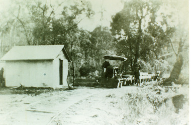
Photograph, 1930c
Black and white photograph of the tramline used to transport red granite from the quarry at Mississippi Creek to the landing at the head of the North Arm, Lakes Entrance, Victoria showing the converted Fordson tractor used to haul the trucks of stone on the 3 foot 6 inch line 105cm approximately 1920 to 1939. Lakes Entrance Victoriawaterways, vegetation -
 Lakes Entrance Regional Historical Society (operating as Lakes Entrance History Centre & Museum)
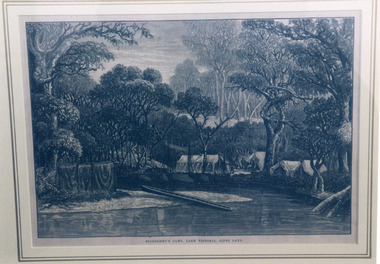
Photograph, Fish, Marie, 1999 c
Photographed from a book illustrationPhotograph of a woodcut depicting an early camp of fishermen on Lake Victoria, Gippsland Lakes, Victoria.Fishermen's Camp, Lake Victoria, Gipps Landvegetation, camping -
 Lakes Entrance Regional Historical Society (operating as Lakes Entrance History Centre & Museum)
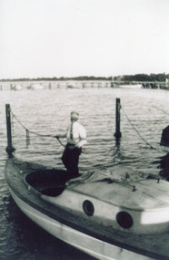
Photograph, Buckland, 1942 c
Man in boat believed to be William BucklandBlack and white photograph of man standing in cockpit of small half cabin sailing type boat tied to mooring poles, jetty with other boats in background. Gippsland Lakes Victoriatransport, vegetation -
 Lakes Entrance Regional Historical Society (operating as Lakes Entrance History Centre & Museum)
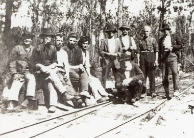
Photograph, 1925 c
Location not identified, may be either Mississippi Creek tramline, or Bairnsdale to Orbost rail line.Black and white photograph of ten men beside a train line, bushland in background. Men appear to be in working clothes. East Gippsland Victoriatransport, vegetation -
Lakes Entrance Regional Historical Society (operating as Lakes Entrance History Centre & Museum)
Photograph, 1927
Black and white copy of postcard taken from Jemmys Point with SS Gippsland in the Narrows passing Rigby Island, Snake Island and outer barrier in distancevegetation, waterfront -
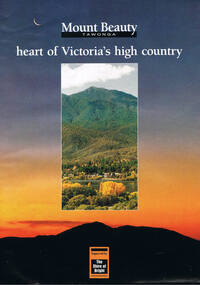 Kiewa Valley Historical Society
Poster Brochure, Mt Beauty Tawonga Heart Of Victoria's High Country, Circa 1995
The Item is a pictorial time piece of the valley and usage, farms,industry,town area, vegetation and winter snow levels Historical and the social-economical development at circa 1995 of land usage and residential buildings style.Major social events e.g. Festival of the Bogong Moth and the Mt Beauty Mardi Gras. It is also a good historical record of tourism campaigns of the Alpine Shire and Mt Beauty Chamber of Commerce. Also see "KVHS 0125"Brochure folds out from a 20.5cm x 29.5cm to 82cm x 29.5cm poster type documentinside panoramic photo of snow tipped alpine mountain range incorporating the Mount Beauty township, farming area of the Kiewa Valley and relevant tourist orientated informationtourism mt beauty tawonga photographs, victorian alps -
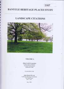 Greensborough Historical Society
Book, Banyule Heritage Places Study. Vol. 3: Landscape Citations, 1999_07
This volume (3) of the Banyule Heritage Places Study: Landscape Citations deals significant vegetation and landscapes within the City of Banyule.127 pages, colour illus., maps. Spiral binding.historic landscapes, city of banyule -
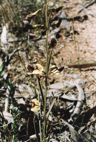 Halls Gap & Grampians Historical Society
Photograph - Coloured
The photo is a close-up of a specimen of a type of native pea growing in the bush. Gum leaves and other vegetation also appear in the photo. The flowers have two main colours; gold and rust brown.natural history, flora -
Bendigo Historical Society Inc.
Document - VICTORIA HILL - LETTER TO MR D ALLEN FROM ALBERT RICHARDSON
Handwritten carbon copy of a letter from Albert Richardson to Mr D. Allen, President of the Rotary Club of Bendigo South thanking the Club for the three weekend working bees clearing the rubbish and vegetation.document, memo, victoria hill, victoria hill, letter to mr d. allen from albert richardson, rotary club of bendigo south, central deborah, albert richardson, bendigo branch of royal historical society, bendigo & district tourist association, bendigo trust -
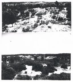 Bendigo Historical Society Inc.
Photograph - LONG GULLY HISTORY GROUP COLLECTION: PHOTO OF MINING AREA
Copy of two black and white photos of a mining area. the top photo shows a hilly area with vegetation and a track and the lower photo shows a bush area with a fence? behind some shrubs in the foreground.bendigo, history, long gully history group, the long gully history group - photo of mining area -
 National Vietnam Veterans Museum (NVVM)
Document, Restricted Intelligence Centre
Yellowing paper Restricted 1: Army Intelligence Ctnre - Revolutionary Warfare - General. Six pages marked Index 2: Intelligence Centre - Topographical Interpretation Vegetation in S.E Asia - eight pagesdocument, restricted intelligence centre -
Whitehorse Historical Society Inc.
Pamphlet, Collina Glen, 2004 - 2007
Collina Glen Bushland Vegetation Action Statement by Parks Wide.Collina Glen Bushland Vegetation Action Statement by Parks Wide stating management recommendations, a sketch of the area, and plant list. Also copies of letters and emails to and from Valda Arrowsmith and Whitehorse Council.Collina Glen Bushland Vegetation Action Statement by Parks Wide. collina glen, mitcham, city of whitehorse, arrowsmith, valda, parks wide, parks and reserves -
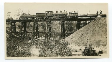
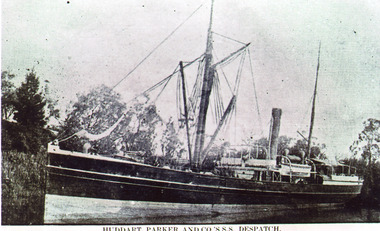 Lakes Entrance Regional Historical Society (operating as Lakes Entrance History Centre & Museum)
Photograph, 1910
Black and white photograph showing SS Despatch, in the Mitchell River, shows beautiful lines of ship, masts and rigging funnel and life boats. Vegetation on river bank behind the vessel. Bairnsdale VictoriaHuddart Parker and Company, SS Despatchships and shipping, islands, waterways -
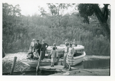 Lakes Entrance Regional Historical Society (operating as Lakes Entrance History Centre & Museum)
Photograph, 1956
Note on back says - Snowy Mountain Tour, M V Loch Ard, North Arm, Lakes Entrance, Tuesday April 17 1956, where we had morning teaBlack and white photograph showing MV Loch Ard in North Arm at tearooms jetty, shows several people on the boat and others on the landing. Thick vegetation on opposite bank. Lakes Entrance Victoriarestaurant, waterways, boats and boating, tourism -
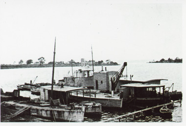 Lakes Entrance Regional Historical Society (operating as Lakes Entrance History Centre & Museum)
Photograph, 1910 c
Photocopy of photograph has names of all the boats, W H Edgar, suction dredge called Paynesville, grab dredge called Priest Man, stores barge called Lady Harriet, a boat used to keep rivers free of snags called Snagger, sand hopper barge from W H Edgar in process of being dismantled. Information provided by Reg Schulz.Black and white photograph showing five boats / barges at slipway, one with crane. Little row boat in foreground at jetty. Point of land in background, Raymond Island, sparse vegetation. Paynesville Victoriaships and shipping, shipwrecks, jetties -
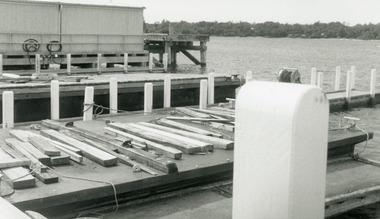
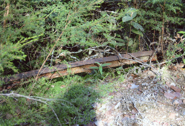 Lakes Entrance Regional Historical Society (operating as Lakes Entrance History Centre & Museum)
Photograph, Davies Judy, 2008
This is the paired after photograph used in the 150 year, Lakes Entrance 1858-2008 display.|The before paired photograph number 01733.3|Also one 12 x 16 framed photograph used in room display.Colour photograph of a remnant of the tramway, beside the walking track, which ran from the Mississippi Creek quarry to the head of the North Arm. It shows one length of ironrail in the vegetation, Lakes Entrance Victoria.waterways, quarries, public works, transport -
 Lakes Entrance Regional Historical Society (operating as Lakes Entrance History Centre & Museum)
Photograph, 1910c
Black and white photograph showing flagstaff and signal baskets on dunes, two women in long dresses on boardwalk, tram track on beach in front of unfinished boardwalk, vegetation on dunes. Lakes Entrance Victoriajetties, waterways -
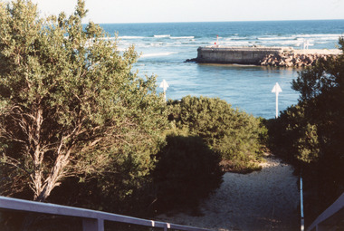 Lakes Entrance Regional Historical Society (operating as Lakes Entrance History Centre & Museum)
Photograph, Holding M, 1997
Date made July 1997Colour photograph of the western pier of the entrance to the Gippsland Lakes from Bass Strait, showing surf breaking on offshore bar, signal triangles, walking path and vegetation in foreground. Lakes Entrance VictoriaEntrance (on back)jetties, topography, waterways -
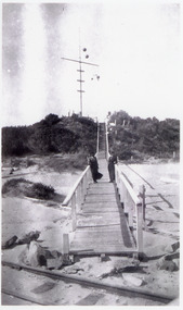
 Lakes Entrance Regional Historical Society (operating as Lakes Entrance History Centre & Museum)
Postcard, Bulmer HD, 1940c
Black and white postcard of the footbridge over the Cunninghame Arm. It shows natural vegetation in the foreground the ramp extension to the bridge, rocks at waters edge town beyond northern shore. Lakes Entrance VictoriaThe Footbridge Lakes Entranceworld war 1914-1918, bridges, waterways, memorials, people -
 Lakes Entrance Regional Historical Society (operating as Lakes Entrance History Centre & Museum)
Photograph, Lakes Post Newspaper, 1995
Date made November 1995Black and white photograph of the Public Works jetty on Bullock Island. It shows the jetty complex built approximately 1970's, Cunninghame Arm and scrubby vegetation on southern shore. Lakes Entrance Victoriaislands, education, topography -
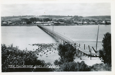
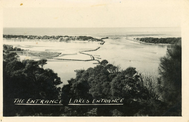 Lakes Entrance Regional Historical Society (operating as Lakes Entrance History Centre & Museum)
Postcard, 1940c
Also one similar images, 7 x 12.5, donated by Pam Cole, Lara VicBlack and white postcard of Bullock Island, and rock groynes, Reeves and Entrance Channels and Carpenter Town at the New Works, taken from Jemmys Point, dense vegetation in foreground. Lakes Entrance VictoriaThe Entrance Lakes Entrancetownship, waterways, topography -
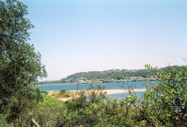 Lakes Entrance Regional Historical Society (operating as Lakes Entrance History Centre & Museum)
Photograph, Davies, Judy, 2005c
Colour photograph of Jemmys Point, Kalimna Heights, and the Western end of the township, taken from the southern shore of Cunninghame Arm. Small sand spit and natural vegetation in foreground. Lakes Entrance Victoriajetties, waterways, topography, township -
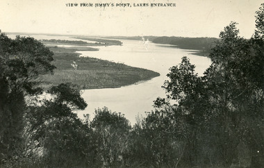 Lakes Entrance Regional Historical Society (operating as Lakes Entrance History Centre & Museum)
Postcard, Bulmer and Segerberg, 1915c
Black and white postcard of the Gippsland lakes, taken from Jemmys Point. It shows Rigby Island, Fraser Island and Flannagan Island, Reeves Channel. Natural vegetation in foreground. Lakes Entrance VictoriaView from Jimmy's Point Lakes Entranceislands, waterways, topography -
 Orbost & District Historical Society
black and white photographs, 20th century
These photographs are probably of bridges on the East Gippsland railway line. 3162.2 is possibly Hospital Creek and 3162.3 possibly Burn Road Newmerella. The Orbost-Bairnsdale railway initially played a crucial role in developing agricultural industries in Gippsland as well as tourism. It opened in 1916 and operated until 1987, principally carrying timber and farming produce. In the early days of the railway's operation dedicated passenger trains ran but these ceased by the 1930s. The line was completely closed to freightage in 1987.The track infrastructure was dismantled in 1994 and has been redeveloped as the East Gippsland Rail Trail.These photographs are associated with the history of the Orbost-Bairnsdale railway line and therefore reflects the role that the rail line played in the social and economic history of Orbost. Three black / white photographs of railway bridges. 3162.1 has a steam train on the bridge. 3162.3 shows three men on the right working at clearing vegetation. 3162.3 has been taken from a height.orbost-bairnsdale-railway east-gippsland-railway bridges-railway -
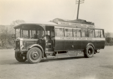 Federation University Historical Collection
Photograph - Black and White, St Hilda's Band bus, 1934, April 1934
Frank Wright was a renown resident of Smeaton, where he was born on 2 August 1901. He lived at Laura Villa, and attended Smeaton State School. His father William was a gold miner and his mother's name was Sarah. Their family won many singing and instrumental awards. Frank was tutored by Percy Code and was awarded a gold medal for the highest marks in the ALCM examinations in the British Colonies at the age of seventeen years. He became the Australian Open Cornet Champion by the age of eighteen. A year later, Frank conducted the City of Ballarat Band, and later the Ballarat Soldiers’ Memorial Band. He formed the Frank Wright Frisco Band and Frank Wright and his Coliseum Orchestra. These bands won many South Street awards, and Frank as conductor won many awards in the Australian Band Championship contest. In 1933 Frank Wright sailed to England to conduct the famous St Hilda’s Band and was later appointed Musical Director of the London County Council, where he organized many amazing concerts in parks, in and around the London district. He was made Professor of Brass and Military Band Scoring and conducted at the Guildhall of Music and Drama. Frank was often invited to adjudicate Brass Band Championships around Europe, in Australia, including South Street and in New Zealand. The Frank Wright Medal at the Royal South Street competition is awarded to an individual recognized as making an outstanding contribution to brass music in Australia.Black and white photograph of a parked 1930's bus. On the far side can be seen a telegraph pole and vegetation. The bus is sign written with 'World's Champion Five Times The Famous St Hildas Band'.Written in pencil on back - Near Hastings, April 1934frank wright, st hildas band, brass band, vintage bus -
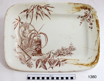 Flagstaff Hill Maritime Museum and Village
Dish
The maker’s initials on the back of the patter, “A.F. & S.” are one of the marks of Alfred Fenton & Sons (& Co) of Brook Street Works (renamed Century Street in 1950’s), Hanley, Staffordshire, Stoke-on-Trent in the United Kingdom. The partners were Alfred Fenton, James Tunstall Fenton, Arthur Fenton and John Fenton. Other initials used are “A F & Co.” The company operated from 1887 to 1901. According to the London Gazette of January 10, 1899, the Earthenware Manufacturers “Alfred Fenton & Sons“ also had a location in Australia at the corner of Elizabeth Street and 314-316 Bourke Street Melbourne Victoria, and Bond Street, Sydney, and in New Zealand at Manse Street, Dunedin. The maker’s mark also includes the word ‘PRAHRAN’, which is an inner suburb of Melbourne. “Prahran” may have been the name of this particular pattern or even the location chosen in preference to the location ‘Melbourne’. The Melbourne address was purchased from a long established drapery business, Wright and Neil, between 1911-1914 by Sidney Myer. Myer constructed his 1914 building in on this site in Bourke Street. This platter is an example of late 19th or early 20th century dinnerware.Dish; white ceramic rectangular platter with picture in brown ink depicting vegetation (including bamboo and blossoms), flower pot, plates and two oriental persons. Made by Alfred Fenton and Sons 1887-1901.Stamped on back, "PRAHRAN / A.F. & S." surrounded by a buckled belt. Number "14" printed in the clay. flagstaff hill, warrnambool, shipwrecked-coast, flagstaff-hill, flagstaff-hill-maritime-museum, maritime-museum, shipwreck-coast, flagstaff-hill-maritime-village, dish, food perparation, dinnerware, catering, a.f. & s., a fenton and son potters of hanley uk, bourke street melbourne, prahran dinnerwear -
 National Vietnam Veterans Museum (NVVM)
Photograph, Enjoying The Shade
A coloured photograph taken in July 1969, An Australian Armoured Personnel (APC) Carrier of B Squadron appears to be swallowed up by the vegetation as it is parked furing a lull in operations. A couple of the crew enjoy the shade of an umbrellaphotograph, apc, 3rd cavalry regiment, gibbons collection catalogue -
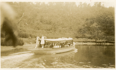 Lakes Entrance Regional Historical Society (operating as Lakes Entrance History Centre & Museum)
Photograph, 1940 c
Sepia photograph showing MV Loch Ard in North Arm. Photo shows vessel approaching landing below Comers Tearooms, with full load of visitors. Thick vegetation on hill. Lakes Entrance Victoriajetties, waterways, boats and boating, tourism -
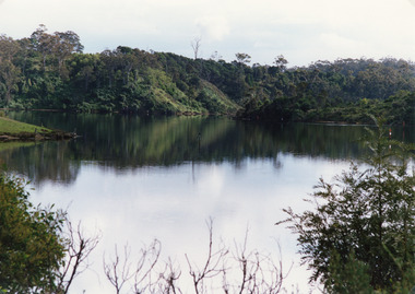 Lakes Entrance Regional Historical Society (operating as Lakes Entrance History Centre & Museum)
Photograph, Tambo Shire, 1990c
Second copy image identical 20.5 x 28.5Colour photograph of a bay in the North Arm. It shows the calm waters of the lake surrounded by steep wooded banks, a grassy point with remains of fence or jetty. Reflections of surrounding vegetation in water. Lakes Entrance Victoriajetties, retail trade, waterways, topography