Showing 519 items
matching architects plans
-
 Glen Eira Historical Society
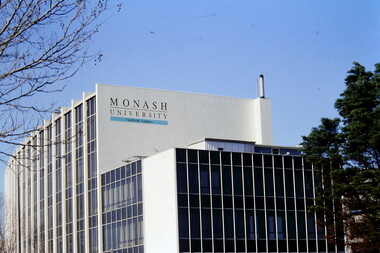
Article - MONASH UNIVERSITY CAULFIELD CAMPUS
This folder contains 6 items about this educational institution: 1/Undated colour slides showing various angles of two different building facades of Monash Caulfield Campus. 2/Article 'Martens Matters' re launch of exhibition of covesr of OASE 33 Magazine by Designer Karel Martens. Date noted as 01/04/2011 in 'The Age'. 3/Collection of 6 separate cards, all Priority Development Panel Submissions, Design Visualization, dated May 2006 (Architectural drafts) dated 31/03/2006 plus 2 identical cards dated 01/05/2006 - all drawings and one plan for NHArchitecture. 4/Collection of 4 colour separate cards, all Priority Development Panel Submissions, Design Visualization for Architect Wojciech Huszek of existing buildingsdated 31/03/2006. 5/Collection of 4 colour separate cards all Priority Development Panel Submissions, Design Visualization of existing buildings by photographer Andrius Lipsys, dated March 2006. (No architect stated.) 6/Article 'Uni rank sign of the Times' from Glen Eira Port Phillip Leader dated 12/03/2013 concerning Monash University’s world ranking in 100 best universities.nharchitecture, altoon and porter (master planner and urban designer ), huczek wojciech (architect), lipsys andrius (photographer), martens karel, station square development, campus map, derby lane, princess lane, post office place, caulfield station, sir john monash drive, derby road, the hub, the mat, post office square, station square, zagame’s hotel, dandenong road, oase 33, art and design building, monash university, caulfield campus, caulfield east, universities, tertiary education -
 Federation University Historical Collection
Booklet - Annual Report, Ballarat School of Mines, Ballarat School of Mines Annual Report, 1969, 1969
This annual report was one year before the opening of the new tertiary division at Mt Helen. Council decided to retain the overall title "The School of Mines and Industries, Ballarat" for the foreseeable future, but to separately name the three divisions as follows: 1. Diploma School - The Ballarat Institute of Advanced Education (A division of the School of Mines and Industries, Ballarat) 2. Trades School - The Ballarat School of Industries (A division of the School of Mines and Industries, Ballarat) 3. Secondary School - The Ballarat Technical School (A division of the School of Mines and Industries, Ballarat). The annual report also foreshadowed the Centenary of the School (and technical education in Australia) in 1970. Speaker at the trade Prize Night and Apprenticeship Week was W.J. Anderson, and Craftsmen Certificates were presented by the Ballarat City Council. A number of quarto pages with stapled inside a brown card cover. The report was for the year ended 30 June 1969, and was delivered by Ballarat School of Mines President M.B. John. Page 5 lists the Diplomas awarded. Page 6 lists the scholarships, prizes and awards, including the Josephine Brelaz Scholarship, Martha Pinkerton Scholarship, Frank Pinkerton Scholarship, Mica Smith/Serjeant/Ironworkers Scholarship, Ballaarat Has Comapny Scholarship, Ballaarat City Council Scholarship, R.W. Richards Medal. Page 8 covers buildings and accommodation. Conditions were cramped at Lydiard Street , with conditions hoped to be improved when the Stage I buildings at Mount Helen were completed in the following year. Mount Helen Master Plan was undertaken by Joint site planners G.J. Harrison, staff architect at the Flinders University of South Australia. and messrs L.H. Vernon and associates, of Ballarat. The following staff members retired: A.L.H. Aldersey; J.V. Crotty; M. Page; J.Ralston; P.J. Smith, P.B. Todd; Derek Wooley; Mr Goldfinch. TRADE DIVISION: F.D. Hamilton, J. Moran, D.Drake The following new lecturing appointments were made during the year: G.I. Boyd; E.W. Butters; D.R. Dowling; P.D. Kelly; G.J. medwell; R.E. Northey; C.A. Pogliani; R.H. Pyke; Roy Schrieke; B.J. Shearer, D.J. Stabb, T.W. Sweatman; A.C. Turner; D.G. Williams; C.M. McGarry. The Computer centre was enlarged when Arch MacKinnon was transferred as Mathematics lecturer to Computer Manager. J.A. Wilson was the computer operator, and R. Kopke, E. Dykstra and V. Gay were Card Punch Operators. Preliminary work on the new Brewing and Malting course was continuing, and plans were being made for the commencement of courses in Librarianship and General Studies. A Halls of Residence Committee had held meetings to explore the type of student accommodation required. ballarat school of mines, library, m.b. john, stohr, robertson, beanland, graeme beanland, arthur nicholson, m.j. brown, anderson, rex hollioake, w.j.c. north, patterson, smail, w.g. smith. sutton, e.j. tippett, webb, white, yandell, mount helen, scholarship, martha pinkerton, josephine brelaz, graham beanland -
 Federation University Historical Collection
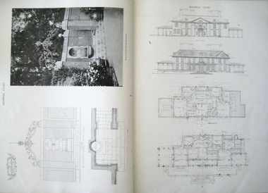
Book, The work of Charles A. Platt, 1913
Charles Platt was born in New York in 1861 and died in 1933. He studied art at the National Academy of Design. In 1880, Charles went to Paris to study landscape painting and, while there, he travelled to Italy with his brother. Though he was influenced by Italian detailing, his designs were not copies of Italian gardens He was known as an architect and illustrator not as a garden designer. In 1880, he trained as an etcher with Stephen Parrish in Gloucester, Massachusetts. He also trained at the National Academy of Design and the Art Students League in New York and later in Paris with Gustave Boulanger and Jules Joseph Lefebvre at the Académie Julian. Charles exhibited his paintings and etchings and gained his first audience in Paris Salon of 1885. Betweem 1880 – 1890 , he made hundreds of etchings of architecture and landscapes. In 1900, Charles received a bronze medal at the Paris Exposition Universelle. In 1907 he designed a townhouse for Sara Delano Roosevelt on East 65th Street in New York. Eleanor Roosevelt called Charles A. Platt "an architect of great taste" who with the townhouse had "made the most of every inch of space." and in 1918, he designed the Freer Art Gallery in Washington. Book, Hard brown Cover. Title on the spine "The work of Charles A. Platt". Manufactural details on spine. Page no. 181. Black & white plates and plans. Stamped on page 43, 93, 123, 135, 161, 171"Picton Hopkins & Sons PTY.LTD"architecture design, domestic architecture, designs and plans, landscape gardening -
 Federation University Historical Collection
Plan, Ballarat School of Mines Building Development, 11/04/1964
With the development of tertiary education in the 1960s and 1970s the Ballarat School of Mines asked Coburn and Associates to design new buildings for the Ballarat School of Mines site, utilising the Ballarat Gaol site. The plans did not proceed, with the Mount Helen Campus being created instead. For information on Herbert L. Coburn go to http://guerin.ballarat.edu.au/curator/honour-roll/honourroll_Coburn,%20H.L.shtmlThree copies of plans by Coburn and Associates, with hand applied colour. The plans relate to a proposed development of the Ballarat School of Mines. .1) - shows the Ballarat School of Mines site, with proposed new buildings. It also shows buildings along Dana Street including the Ballarat Club, as well as White Flat. .2) View of proposed Library and Union Building .3) View of proposed Engineering Buildinguniversity of ballarat, ballarat school of mines, architect, herbert coburn, herbert l coburn, coburn and associates, architectural plans -
 Federation University Historical Collection
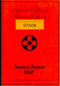
Book, Ballarat College of Advanced Education Annual Report, 1987, 1987
Ian Gordon was the Ballarat College of Advanced Education President in 1988. Orange soft covered annual report. Contents include: Financial Statement, Retirement of Lindsay Hillman, E.J. Barker, Adrian Thomas, Henry Moritz, Brian Lees, Isobel Dowling, Marney Poole, Keith Davison; Staff appointments, Allan Mann, Adrian Mauriks, John Crowe, Max Brooke, Gayle Richards, Kaye Arnel, Ron Keno, George Fong, Berverley Taylor, Alan Donelly, Krystina Antosiewicz, Donna Tiller, Dorothy Lea, Barbara Trudinger, Duc Thac, Susan Parks, Janice Newton, Angus McLachlan, Peter Kirkpatrick, Digma Magsino-Tjoe, Julie King, Mary Walker, Gerry Bushnell, Malcolm Dorricott; Staff obituary, Ron Shaw; Urban Koala Project (Pat Prevett). The Human Studies Building was opened (Architect: Ewan Jones & Associates ), PABX installed, plans were developed for a Creche on campusballarat college of advanced education, bcae, mt helen, mount helen, hillman, barker, prevatt, koalas, barry jones, -
 Flagstaff Hill Maritime Museum and Village
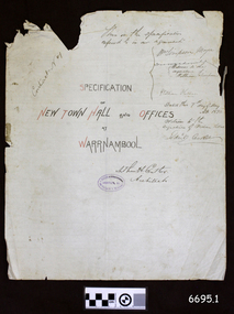
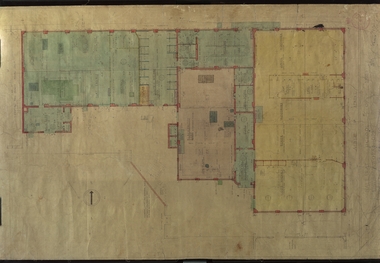
Legal record - Plans and Contract, Arthur H. Cutler, Architect, Warrnambool Town Hall, 1890-1892
This is a set of documents including three sheets of blueprint plans for the New Town Hall and Offices for Warrnambool, created in 1890 by the Architect Mr Arthur H. Cutler of Melbourne. The Contract was signed by the Town Mayor for Warrnambool, Mr William Simpson on May 7th 1890. Also, a Council copy of the Contract dated 26 June 1890, with the signatures and diagram where the two official stamps would be placed. The Foundation Stone was laid the following year by the next Mayor, John Hyland on February 24th 1891. The contractor for the building was granted to W. Kellas (William) of Warrnambool. The Town Hall and Offices were built on the corner of Liebig and Timor Streets in Warrnambool. On March 20th 1983 the new Performing Arts Centre was opened y the Mayor, Councillor R w Andreson, on the same site. The new building incorporates the 1890 Town Hall building. The plans, contracts, documents and various references to people on the documents are significant to the history of the City of Warrnambool and its community. The Warrnambool Town Hall building is also significant for the many community events held there over the decades after it was built. Appreciation for the significance of the almost century-old Town Hall building is demonstrated by its inclusion in the new Performing Arts Centre.Set of five documents that includes Plans for the Warrnambool Town Hall, the Contract cover page and a letter from the Architect to the Council. The Contract cover page and the Letter are hand written on cream-coloured paper with a waxy finish, with watermarks. 1) Contract Cover Page, 5th May 1890, Specification of the New Town Hall and Offices at Warrnambool. 2) Letter, 29th January 1892, from Architect Arthur H. Cutler to Mayor and Councilors, Town of Warrnambool 3) Blueprint Sheet 4, Longitudinal Section, and profiles of Liebig Street and Timor Street, Warrnambool Town Hall, 4) Blueprint Sheet 3, First Floor & Balcony Plan, and Roof Plan 5) Blueprint Sheet 2, Ground Floor Plan, Warrnambool Town Hall 6) Contract, 26 June 1890, marked (Draft Copy Tow Hall Contract), Between Mayor, Councillors and Rate Payers, and William Kellas, ContractorWatermarks on handwritten pages [horizontal lines], "36" "BUSBRIDGE'S / LOFT DRIED" Contract cover page, Oval stamp "CUTLER - 281 COLLINS ST. E. MELBOURNE - ARCHITECT " (other crossed out text) Handwritten script "This is the specifications referred to in our agreement" "Dated this 7th day of May A.D. 1890" Signed "W. Simpson Mayor" "Arthur H. Cutler Architect", [two Witnesses' signatures and others] Letter from Arthur Cutler, handwritten, has his address "472 Chancery Lane, Melbourne" CONTRACT of 26 June 1890: "The Mayor, Councillors and Rate Payers of Warrnambool" "William Kellas of Warrnambool" "Signed William Simpson, Maoyorr" "R F Kennedy, Councillor" "Wm Kellas" with diagrams where the round Common Seal and square Stamp would be applied.warrnambool, flagstaff hill, warrnambool, flagstaff hill maritime museum, maritime village, shipwreck coast, great ocean roaad, warrnamboo town hall, warrnambool council offices, mayor william simpson, arthur h cutler, architect, civic centre, town hall, performing arts centre, mayor john hyland, william kellas, mayor r w anderson, r f kennedy, contract -
Federation University Historical Collection
Plan, Plan of 130 Victoria Street, Ballarat East, 1989, 1989
... photocopy of a plan of the proposed layout of dwelling and Student ...A colour photocopy of a plan of the proposed layout of dwelling and Student Dining / Kitchen Amenity at 130 Victoria Street.student residences, ballarat school of mines, 130 victoria street -
 Federation University Historical Collection
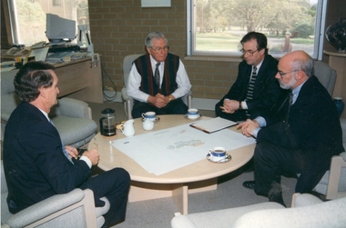
Photograph - Photograph - Colour, Planning Greenhill Enterprise Centre, 1996, 1996
... Crisp (architect). Planning Greenhill Enterprise Centre, 1996 ...At the Ballarat Technology Park (BTP) the spirit of innovation and entrepreneurship enables techno-driven businesses to thrive and prosper, in a dynamic and supportive environment. This fast evolving precinct encourages and supports the development of emerging and existing technology-oriented enterprises. Currently, more than 30 enterprises are located at the Park, including IBM, State Revenue Office, Emergency Services Telecommunications Authority, Primary Health Care and others. The Park's ideal location on the outskirts of Ballarat provides great lifestyle opportunities as well as having the convenience of being close to Melbourne, Geelong, Bendigo and Western Victoria. The BTP is a prestigious 29 hectare site set in a park-like environment, 7km from the thriving regional city of Ballarat. It is easily accessible from Melbourne, Geelong and Bendigo. Adjacent to Federation University's Mt Helen Campus, the BTP is ideally situated to support innovative technology-based enterprises grow and prosper. Enterprises can access skilled graduates through the University, as well as take advantage of the applied, academic and research knowledge available. BTP has been successfully supporting and fostering industry, innovation and job creation since 1995.Colour photograph of four men are seated at a low round table viewing design development drawings of the Greenhill Enterprise Centre prior to commencing documentation for tender purposes. They are Alan Webb (University of Ballarat Director, Buildings and Grounds), Professor David James (University of Ballarat Vice Chancellor), Michael Vincent (architect) and James Crisp (architect).ballarat technology park, university of ballarat., greenhill enterprise centre -
 Federation University Historical Collection
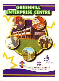
Magazine, Greenhill Enterprise Centre Magazine
This magazine was probably a supplement of the Ballarat Courier at the time of the opening of the Greenhill Enterprise Centre, Ballarat Technology Park. 31 October 1997 - Official opening of Greenhill Enterprise Centre by the Hon. Alan Stockdale, Treasurer and minister for multimedia. Coloured magazine of 18 pages relating to the Greenhill Enterprise Centre. Contents include: * What is an enterprise Centre? * Ballarat well placed to be regional IT leader * Alan Stockdale to open Greenhill Enterprise Centre * Push to create 6000 IT jobs by year 2010 * Internet to bring world to Ballarat * Boost for Remote Schooling * Keeping on track with OZtrack * Ozdate improves methods of data collection * Benefits in university and IBM relationship * Centre for Rural and Regional Information One of first tenants. * IT exchange program to benefit university students * Complementing the environment. * IBM Global first firm to invest in Ballarat Technology Park * University art on show at IBM Images include: * Professor David James and Premier Jeff Kennett planting a tree to mark the State Government's Support for the Greenhill Enterprise Centre * Vincent Chrisp's Architects impression of the completed Greenhill Enterprise Centre * Ballarat City Executive Director of Economic development, David Miller, at the Town Hall. *Greenhill Enterprise Centre floor plan * Associate Professor Gerry Anderson * Paul Kelly * Leanne Woodartgreenhill enterprise centre, ballarat technology park, stockdale, vincent chrisp, david james, geoff kennett, david miller, a.w. nicholson, gerry anderson, peter reid, oztrak, ozdata, centre for rural and regional information, ibm global services centre, michael chrisp, oswego state university, new york, peter biznet, ibm -
Federation University Historical Collection
Drawing - Rubbing, Rubbing on a plaque relating to the Sky High Restaurant
This is thought to be the work of Keith Rash of Ballarat.A number of rubbings from plaques on buildings. .1) Sky High Restaurant .2) Pioneers Tablet (Probably relating to the Pioneers Plot at the Ballaarat Old Cemetery. .3) and .4) Plaque relating to the Pioneers tablet.1) This Skyhigh restaurant was officially opened by The Hon. Vance Dickie M.L.C. Minister for Tourism on the 25th March 1971 This building was planned and constructed for The Ministry of Tourism J. Dale Fisher F.R.A.I.A. Architect W.J. Cody & Quinn Pty Ltd Builders .2) (logo) This tablet was erected by the citizens of Ballarat in honour of the pioneers of this city and district. .3) This MEMORIAL TABLET was unveiled on the 3rd May 1961 by F.W. WRAY, Esq in the company of S.C. HENDERSON, Esq. The only remaining members of the Original Pioneers Memorial Committee.architecture, j. dale, w, j, cody & quinn, skyhigh restaurant, frottage, rubbing, ballarat pioneers, keith rash -
 Federation University Historical Collection
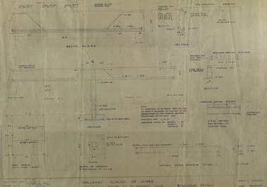
Plans, Ballarat School of Mines New Workshops, 1944, 17/11/1944
Four coloured plans and one copy of the new trades building at the Ballarat School of Mines.ballarat school of mines, architecture, trades, plumbing, percy everett, architectural drawing -
 Federation University Historical Collection
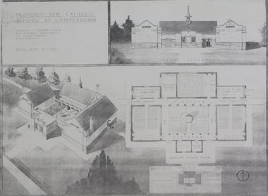
Plan (copy), 'Proposed New Catholic School at Camperdown' by Herbert L. Coburn
Ballarat born Herbert L. Coburn grew up to be a renowned Ballarat architect, practising from 1905 to 1956. He taught Architecture and Building Construction at the Ballarat School of Mines (SMB) from 1918, resigning in 1948 due to ill health. Copy of a plan for a Catholic primary school at Camperdown by H.L. Coburn. The plan includes front elevation, ground floor and block plan.coburn, h.l. coburn, herbert l. coburn, architecture, camperdown, architectural plan -
 Federation University Historical Collection
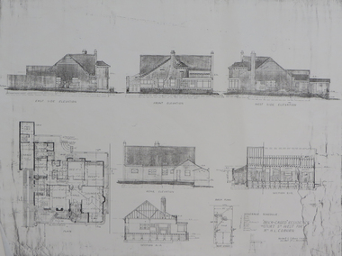
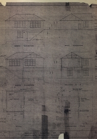
Plan - Plan (copy), 'Brick cased Residence 1515 Sturt Street West for Mrs H.L. Coburn, by H. Leslie Coburn, not dated
Ballarat born Herbert L. Coburn grew up to be a renowned Ballarat architect, practising from 1905 to 1956. He taught Architecture and Building Construction at the Ballarat School of Mines (SMB) from 1918, resigning in 1948 due to ill health.Copy of a plan by H.L. Coburn. It includes a front, west, east and rear elevation; ground plan, block plan; and layout plan. herbert l. coburn, h.l. coburn, coburn, architecture, herbert coburn, architectural plan -
 Federation University Historical Collection
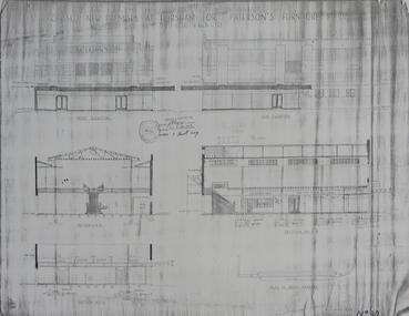
Plans (copy), 'Proposed new Premises at Horsham for Paterson's Furniture Pty Ltd' by Herbert L. Coburn, not dated
Ballarat born Herbert L. Coburn grew up to be a renowned Ballarat architect, practising from 1905 to 1956. He taught Architecture and Building Construction at the Ballarat School of Mines (SMB) from 1918, resigning in 1948 due to ill health.Copy of 2 plans for a proposed double storey building at Horsham for Paterson's Furniture Pty Ltd.: .1) Ground and first floor plans .2) Elevationsherbert l. coburn, h.l. coburn, coburn, architecture, horsham, paterson's furniture pty ltd, architectural plan -
 Federation University Historical Collection
Plans, Plans of the Ballarat School of Mines, Lydiard Street South, Ballarat, 1953
.3) Ballarat School of Mines plan for water supply installation to prefabricated classrooms associated with the Ballarat Girls' Techncial School, April 1953 .4) Ballarat School of Mines plans for three prefabricated classrooms to be used as the Ballarat Girls' Techncial School, Hickman Street, Ballarat by Percy E. Everett, 16 December 1952. Earthworks undertaken by T.G. James. .5) Ballarat Sewerage Authority Plan of Drainage Prefabricated Class Rooms Ballarat School of Mines by Chief Architect Percy E. Everett, 13 April 1953. The plan shows basket ball court and shelter, classrooms, contours, excavations and girls toilet associated with the Ballarat Girls' Techncial School, Hickman Street, Ballarat. ballarat junior girls' technical school, ballarat girls' technical school, ballarat school of mines, hickman street, white flat, t.g. james -
 Federation University Historical Collection
Plan, Ballarat School of Mines Additional Rooms to Plumbing Shop, by Chief architect Percy E. Everett, 1945, 14/01/1945
.1) Copy of structural details for additional rooms for the Ballarat School of Mines Plumbing Building, 1945 .2) Copy of structural details for additional rooms for the Ballarat School of Mines Plumbing Building, 1945 .3) Copy of an engineering plan for additional rooms for the Ballarat School of Mines Plumbing Building, 1948 .4) Copy of a plan for additional rooms for the Ballarat School of Mines Plumbing Building, 1945ballarat school of mines, plumbing, architectural plan -
 Federation University Historical Collection
Plan, Ballarat School of Mines Plumbing Building additions, 1948, 1948
Copy of plans showing elevations for additions to the Ballarat School of Mines Plumbing Shopballarat school of mines, plumbing, architectural plan -
 Federation University Historical Collection
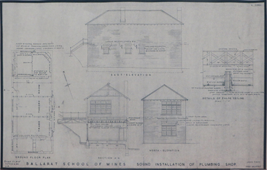
Plan (copy), Ballarat School of Mines Plumbing Building, 1954
.1) Ballarat School of Mines Sound Installation of Plumbing Shop, by architect John Firth, 1954 .2) Plan and sections of the proposed Scheme - conversion of Ballarat School of Mines Clay Mill Building to Fluid Mechanics Laboratory, by architect John E. Dixon, 1962 .3) Plan for Ballarat School of Mines New Sanitary Accomodation, 1967 .4) Plan for Ballarat School of Mines Extension to Existing Workshop by architect Percy E. Everett. The plan includes the former Ballarat Supreme Courtjohn firth, percy everett, john e. dixon, ballarat school of mines, clay, ceramics, plumbing, buildings, architectural plan -
Federation University Historical Collection
Booklet, GIAE Official Opening, 1976, 11/1976
The Gippsland Institute of Advanced Education was established by an Order-in-Council in September 1968. On its establishment, the Institute assumed responsibility for the diploma coursed previously offered at Yallourn Technical College. In 1972 the Institute transferred part of its operations to the first of its permanent buildings on a large campus in rural surrounding near the township of Churchill, ten kilometres south of Morwell, and 160 kilometres east of Melbourne. The campus site plan report prepared in 1970 by the Institute's campus planners, Yuncken Freeman Architects Pty Ltd, provided the conceptual base for the development of a new campus at Churchill. All facilities were planned to converge on a central space; all having the ability to expand outwards. Central to the campus plan was the concept of an internal pedestrian street connecting all academic divisions to the central facilities. The first building was completed in 1972. The Administration Building, Visual Art & Maintenance Workshops, Multi-Purpose Building, and Student residences were designed by Yuncken Freeman Architects. The central Facilities Building (cafeteria and Union) were designed by Chancellor and Patrick, the Education Building and Applied Science Building is designed by Eggleston, McDonald and Secomb.Grey and yellow soft covered booklet prepared for the official opening of Gippsland Institute of Advanced Education.gippsland institute of advanced education, gippsland campus, churchill, m.w. hopper, c.h. ford, lindsay thompson, j.l. carrick, r.w. muncey -
 Federation University Historical Collection
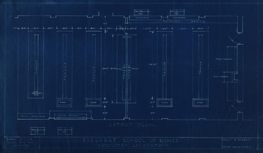
Plan, Ballarat School of Mines Chemistry Laboratory Plan, 10/11/1950
Four blue line plans relating to the Ballarat School of Mines Chemistry Laboratory.ballarat school of mines, chemistry, laboratory, percy everett, old chemistry building -
 Federation University Historical Collection
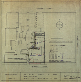
Plan - Plans, Ballarat School of Mines New Workshops, 1944, 17/11/1944
This building has been demolished to make way for new buildings along Albert Street. According to E.J. Barker this was Metal Fabrication.Plans (dyeline) for new building along the Ballarat School of Mines Albert Street frontage .1) Ballarat School of Mines New Workshops .2) as above Scale 1:480 WGS 84 37 degrees 33 feet 54 inches south 143 degrees 50 feet 30 inches eastSheet No 3 F.G.B.ballarat school of mines, metal fabrication, albert street, buildings, plan, heat engines room, model mine, blacksmiths shop, blacksmithing, carpenters shop, engineering shope, percy everett -
 Federation University Historical Collection
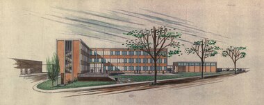
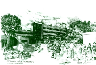
Photograph - Photograph - Black and White, Proposed Ballarat School of Mines Trade Workshops, c1984
A design for a Trade and Art Workshop at the Ballarat School of Mines was prepared by Ewan Jones and Associates on the Albert Street boundary around 1984. The M.B. John Building (Building K), a three storey, face red brick, restrained Late Twentieth Century International styled building with an elongated, cuboid form (defined by the parapeted facades) that is offset by projecting exposed concrete framed, round‐arched entrance and stair wells on the east (Albert Street) elevation (the centrally located entrance breaking the brick façade with glazing). The facades are also characterised by banks of aluminium framed, horizontal ribbon windows, which wrap around the building corners. Metal shades project beyond the windows, while post‐supported bullnosed verandahs and hoods and projecting concrete stairs are other features. On the west elevation, the cuboid façade is punctuated by projecting curved concrete and glazed, elongated bays at first floor level. (David Rowe/Wendy Jacobs) The M.B. John Trade–Art building of SMB was officially opened by the Hon. John Cain, Premier of Victoria, in the presence of Morgan B. John. Programs include 3 Dimensional Art, Painting & Decorating, and Engineering Trades. (SMB Institutional Plan 1989)Black and white photograph of a sketch for the proposed Trade Workshops at the Ballarat School of Mines, from the Albert Street vantage point. This building is known as the M.B. John Building on the SMB Campus.ballarat school of mines, trade workshops, flecknoe, m.b. john, ewan jones and associates pty ltd, albert street, morgan b. john, ewan jones and associates -
 Federation University Historical Collection
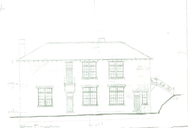
Plan, West Elevation of the Ballarat School of Mines Building Old Plumbing Building
This building was built in 1918-19 to a design by H.J. Kerr, District Architect (Western District), under the design control of the Chief Architect, S.C. Brittingham, Public Works Department. Their initials appear on the attached copy of the original drawing of the building. (Research by David Rowe)Copy of the Plumbing building on the grounds of the Ballarat School of Mines campusballarat school of mines, plans, building o, plumbing, old plumbing building, h.j. kerr, s.c. brittingham -
 Federation University Historical Collection
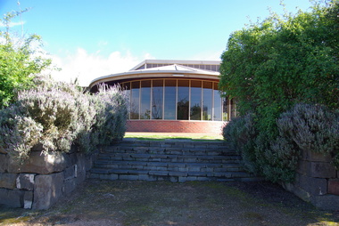
Photograph, Federation University Australia E.J. Tippett Library, 2013, 23/09/2013
The E.J. Tippett Library is named after the late E.J. Tippett who was a long time President of the Ballarat School of Mines Council, and library advocate. In February 1985, the first sod for the new SMB Campus building was turned by the Minister for Planning and the Environment, the Hon. Evan Walker, M.P. The overall responsibility for the building rested with the Public Works Department in association with the SMB Campus architect, Ewan Jones & Associates and the builder, S. J. Weir Pty. Ltd. They put together the facility that is both functional and of a style that merges with the surrounding architecture. The new building was opened on 04 July 1986 by Governor of Victoria, His Excellency Dr Davis McCaughey.Two colour photographs showing the exterior of the E.J. Tippett Library at Federation University Australia SMB Campus, and two taken from inside the library looking over Ballarat East.e.j. tippett library, tippett library, smb library, tippett, e.j. tippett, ewan jones & associates -
Federation University Historical Collection
Document - Conservation Management Plan, Wendy Jacobs et al, Ballarat Municipal Observatory - Conservation Management Plan
A Conservation Management Plan of the Ballarat Municipal Observatory, produced by Dr David Rowe of Authentic Heritage Services Pty Ltd and Wendy Jacobs, Architect & Heritage Consultant for the City of Ballarat and the Ballaarat Astronomical Society in April 2007.astronomy, ballarat observatory, ballarat municipal observatory, conservation management plan, cmp -
 Flagstaff Hill Maritime Museum and Village
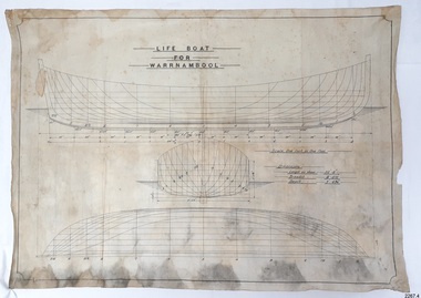
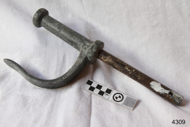
Plan - Vessel Line Drawing, Life Boat for Warrnambool, ca. 1900-1909
The plans were used for the construction of the lifeboat ‘Warrnambool’, which began 15th September 1909 and was completed almost 12 months later 1st September 1910. It was built at the Government Dockyard in Williamstown, Victoria, along the lines designed by Great Britain’s Royal Lifeboat Institution, and included whaleback decks fore and aft, mast and centreboard, and rudder and tiller hung from the sternpost. It could be propelled by both sail and oar. At that time Captain Ferguson was Chief Harbour Master and Mr Beagley was the foreman boat builder. Mr Beagley built the lifeboat with his fellow workmen. The boat was described as “… a fine piece of workmanship and does credit to her builders and designers…” It had all the latest improvements in shape, disposition of weight and watertight compartments, and it had space for a large number of people in addition to the crew. It appears that 'H Meiers' whose signature was on the plaque that was found concealed in the hull, was involved with the building of the lifeboat. His signature and the dates of the start and finish of the boat’s construction are pencilled on the raw timber 'plaque' found in the hull in the early 1990s when the lifeboat was being restored. It is interesting that the ‘Melbourne Directory’ of 1911, published by Sands and MacDougal, lists McAuley and Meiers, boat builders, Nelson Place foreshore, between Pasco and Parker Streets, Williamstown, (Victorian Heritage Database, ‘Contextual History, Maritime Facilities’), It is quite possibly the business of the person whose name is inscribed on the lifeboat plaque. Flagstaff Hill’s documentation also mentions that the keel was laid at ‘Harry Myers, boat builders, Williamstown, Melbourne’ – the name ‘Myers’ can also be spelled ‘Meiers’, which could be the same person as the Meiers in “McAuley and Meiers” (as mentioned in genealogy lines of Myers). The new lifeboat, to be named ‘Warrnambool’ was brought to town by train and launched at the breakwater on 1st March 1911 using the Titan crane (the old lifeboat built in 1858, was then returned to Melbourne in 1911). This new lifeboat was stationed at Warrnambool in a shed located at the base of the Breakwater, adjacent to the slipway. A winch was used to bring it in and out of the water. The lifeboat ‘Warrnambool’ was similar in size to the old lifeboat but far superior in design, build and sea-going qualities such as greater manoeuvrability. The ‘self-righting, self-draining design was “practically non-capsizeable” and even if the boat overturned it would right itself to an even keel and the water would drain away. The hull was built of New Zealand Kauri, using double diagonal planking, laid in two layers at right angles, with a layer of canvas and red lead paint between the timbers to help seal the planking. It has “… plenty of freeboard area, high watertight spaces between the deck and bottom… through which pipes lead…” The backbone timbers were made of Jarrah. The lifeboat Warrnambool was one of several rescue boats used at Port Fairy and Warrnambool in the early 1900s. In late 1914 the Warrnambool lifeboat and crew were used to help find what was left of the tragic wreckage of the Antares and were able to discover the body of one of the crewmen, which they brought back to Warrnambool. Between 1951 and 1954 the lifeboat was manned under the guidance of Captain Carrington. He held lifeboat practice each month on a Sunday morning, to comply with the Ports and Harbour’s request that lifeboats be manned by a strong and competent crew, ready for action in case of emergency. In the early 1960’s it ended its service as a lifeboat and was used in Port Fairy as a barge to help dredge the Moyne River, bolted to the Port Fairy lifeboat. Flagstaff Hill obtained the Warrnambool in 1975. In 1984 it was on display at Flagstaff Hill Maritime Village, Warrnambool. On 23rd May 1990, she was lifted from the water and placed in a cradle for restoration. The name ‘WARRNAMBOOL could be seen faintly on the lifeboat before it was restored. It was during the restoration that Flagstaff Hill's boat builder discovered the 'plaque' inside the hull. A copy of the blueprint plans has the name “V.E.E. Gotch” printed on it. His advertisement in Footscray’s ‘Independent’ newspaper of Saturday 11th May 1901 states he is “Principal and Skilled member (Naval Architect) to the Court of Marine Inquiry of Victoria and holds classes for naval architectural drawing and arithmetic.” The line drawing is significant for its connection with the lifeboat WARRNAMBOOL. The lifeboat is very significant to local and state history for its use in the lifesaving rescues of seafarers, particularly in Lady Bay. It was part of the local rescue equipment. It gave a half-century of service to the local community as a lifesaving vessel, including its involvement in retrieving the body of a shipwrecked crew member of the ANTARES. Line drawing in black ink and pencil on rectangular parchment or waxed linen. Drawing has diagrams of three profiles of a vessel, with measurements and connecting pencil lines on the left quarter. The plan is for the lifeboat named “Warrnambool”, which was built in Melbourne and completed in 1910. Old blue copies of the Lifeboat plan are archived also.“LIFE BOAT / FOR / WARRNAMBOOL” “Scale, One Inch to One Foot” “ “Length as shown 30’ – 8” “ “Breadth “ “ 8’ – 6 ½ “ “ “Depth “ “ 3’ – 4 ¾” “flagstaff hill, warrnambool, shipwrecked-coast, flagstaff-hill, flagstaff-hill-maritime-museum, maritime-museum, shipwreck-coast, flagstaff-hill-maritime-village, lifeboat, warrnambool lifeboat, boat plans, lifeboat plans, boat construction, boat building, line drawing, plan for lifeboat, life boat, life boat 'warrnambool', clinker design, 1910 lifeboat, life saving equipment, shipbuilding -
 Flagstaff Hill Maritime Museum and Village
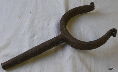
Rowlock, early 20th century
Rowlock from the Lifeboat Warrnambool, which is on site at Flagstaff Hill Maritime Village. The construction of the lifeboat ‘Warrnambool’ began 15th September 1909 and was completed almost 12 months later, 1st September 1910. It was built at the Government Dockyard in Williamstown, Victoria, along the lines designed by the Great Britain’s Royal Lifeboat Institution, and included whaleback decks fore and aft, mast and centreboard, and rudder and tiller hung from the sternpost. It could be propelled by both sail and oar. At that time Captain Ferguson was Chief Harbour Master and Mr Beagley was foreman boat builder. Mr Beagley built the lifeboat with his fellow workmen. The boat was described as “… a fine piece of workmanship and does credit to her builders and designers…” It had all the latest improvements in shape, disposition of weight and watertight compartments, and it had space for a large number of people in addition to the crew. It appears that 'H Meiers' whose signature was on the plaque that was found concealed in the hull, was involved with the building of the lifeboat. His signature and the dates of the start and finish of the boat’s construction are pencilled on the raw timber 'plaque' found in the hull in the early 1990’s when the lifeboat was being restored. It is interesting that the ‘Melbourne Directory’ of 1911, published by Sands and MacDougal, lists McAuley and Meiers, boat builders, Nelson Place foreshore, between Pasco and Parker Streets, Williamstown, (Victorian Heritage Database, ‘Contextual History, Maritime Facilities’), It is quite possibly the business of the person whose name is inscribed on the lifeboat plaque. Flagstaff Hill’s documentation also mentions that the keel was laid at ‘Harry Myers, boat builders, Williamstown, Melbourne’ – the name ‘Myers’ can also be spelled ‘Meiers’, which could be the same person as the Meiers in “McAuley and Meiers” (as mentioned in genealogy lines of Myers). The new lifeboat, to be named ‘Warrnambool’ was brought to town by train and launched at the breakwater on 1st March 1911 using the Titan crane (the old lifeboat built in 1858, was then returned to Melbourne in 1911). This new lifeboat was stationed at Warrnambool in a shed located at the base of the Breakwater, adjacent to the slipway. A winch was used to bring it in and out of the water. The lifeboat ‘Warrnambool’ was similar in size to the old lifeboat but far superior in design, build and sea-going qualities such as greater manoeuvrability. The ‘self-righting, self-draining’ design was “practically non-capsizeable” and even if the boat overturned it would right itself to an even keel and the water would drain away. The hull was built of New Zealand Kauri, using double diagonal planking, laid in two layers at right angles, with a layer of canvas and red lead paint between the timbers to help seal the planking. It has “… plenty of freeboard, high watertight spaces between the deck and bottom… through which pipes lead…” The backbone timbers were made of Jarrah. The lifeboat Warrnambool was one of several rescue boats used at Port Fairy and Warrnambool in early 1900's. In late 1914 the Warrnambool lifeboat and crew were used to help find what was left of the tragic wreckage of the Antares, and were able to discover the body of one of the crewmen, which they brought back to Warrnambool. Between 1951 and 1954 the lifeboat was manned under the guidance of Captain Carrington. He held lifeboat practice each month on a Sunday morning, to comply with the Ports and Harbour’s request that lifeboats be manned by a strong and competent crew, ready for action in case of emergency. In the early 1960’s it ended its service as a lifeboat and was used in Port Fairy as a barge to help dredge the Moyne River, bolted to the Port Fairy lifeboat. Flagstaff Hill obtained the Warrnambool in 1975. In 1984 it was on display at Flagstaff Hill Maritime Village, Warrnambool. On 23rd May 1990 she was lifted from the water and placed in a cradle for restoration. The name ‘WARRNAMBOOL could be seen faintly on the lifeboat before it was restored. It was during the restoration that Flagstaff Hill's boat builder discovered the 'plaque' inside the hull. A copy of the blueprint plans has the name “V.E.E. Gotch” printed on it. His advertisement in Footscray’s ‘Independent’ newspaper of Saturday 11th May 1901 states he is “Principal and Skilled member (Naval Architect) to the Court of Marine Inquiry of Victoria and holds classes for naval architectural drawing and arithmetic.” The rowlock is significant for its association with the lifeboat WARRNAMBOOL, which is significant for its half century service to the local community as a lifesaving vessel. She was also used to help retrieve the body of a shipwrecked crew member of the ANTARES. Rowlock, iron, upper ends scroll over, from the Lifeboat Warrnambool.flagstaff hill, warrnambool, shipwrecked-coast, flagstaff-hill, flagstaff-hill-maritime-museum, maritime-museum, shipwreck-coast, flagstaff-hill-maritime-village, life boat, life saving vessel, 1910 vessel, port fairy, boat builder plaque, rescue boat, beagley, government dockyard, williamstown, v.e.e. gotch, royal lifeboat institution, captain ferguson, non-capsizeable lifeboat, self-righting lifeboat, antares shipwreck, double diagonal planking, captain carrington, rowlock, lifeboat rowlock, lifeboat warrnambool -
 Flagstaff Hill Maritime Museum and Village
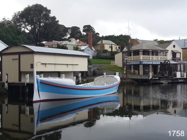
Vehicle - Vessel, Lifeboat Warrnambool, 01/09/1910
The construction of the lifeboat ‘Warrnambool’ began 15th September 1909 and was completed almost 12 months later, 1st September 1910. It was built at the Government Dockyard in Williamstown, Victoria, along the lines designed by the Great Britain’s Royal Lifeboat Institution, and included whaleback decks fore and aft, mast and centreboard, and rudder and tiller hung from the sternpost. It could be propelled by both sail and oar. At that time Captain Ferguson was Chief Harbour Master and Mr Beagley was foreman boat builder when he and his fellow workmen built the boat. The boat was described as “… a fine piece of workmanship and does credit to her builders and designers…” It had all the latest improvements in shape, disposition of weight and watertight compartments, and it had space for a large number of people in addition to the crew. It appears that 'H Meiers' whose signature, along with building dates, is pencilled on a concealed timber 'plaque' in the hull, was involved with the building of the lifeboat. It is interesting that the ‘Melbourne Directory’ of 1911, published by Sands and MacDougal, lists McAuley and Meiers, boat builders, Nelson Place foreshore, between Pasco and Parker Streets, Williamstown, (Victorian Heritage Database, ‘Contextual History, Maritime Facilities’), It is probably the company of the person whose name is inscribed on the lifeboat plaque. Flagstaff Hill’s documentation also mentions that the keel was laid at ‘Harry Myers, boat builders, Williamstown, Melbourne’ – the name ‘Myers’ can also be spelled ‘Meiers’, which could be the same person as the Meiers in “McAuley and Meiers” (as mentioned in genealogy lines of Myers). The new lifeboat, to be named ‘Warrnambool’ was brought to town by train and launched at the breakwater on 1st March 1911 using the Titan crane (the old lifeboat built in 1858, was then returned to Melbourne in 1911). This new lifeboat was stationed at Warrnambool in a shed located at the base of the Breakwater, adjacent to the slipway. A winch was used to bring it in and out of the water. The lifeboat ‘Warrnambool’ was similar in size to the old lifeboat but far superior in design, build and sea-going qualities such as greater manoeuvrability. The ‘self-righting, self-draining’ design was “practically non-capsizeable” and even if the boat overturned it would right itself to an even keel and the water would drain away. The hull was built of New Zealand Kauri, using double diagonal planking, laid in two layers at right angles, with a layer of canvas and red lead paint between the timbers to help seal the planking. It has “… plenty of freeboard, high watertight spaces between the deck and bottom… through which pipes lead…” The backbone timbers were made of Jarrah. The lifeboat Warrnambool was one of several rescue boats used at Port Fairy and Warrnambool in early 1900's. In late 1914 the Warrnambool lifeboat and crew were used to help find what was left of the tragic wreckage of the Antares, and were able to discover the body of one of the crewmen, which they brought back to Warrnambool. Between 1951 and 1954 the lifeboat was manned under the guidance of Captain Carrington. He held lifeboat practice each month on a Sunday morning, to comply with the Ports and Harbour’s request that lifeboats be manned by a strong and competent crew, ready for action in case of emergency. In the early 1960’s it ended its service as a lifeboat and was used in Port Fairy as a barge to help dredge the Moyne River, bolted to the Port Fairy lifeboat. Flagstaff Hill obtained the Warrnambool in 1975. In 1984 it was on display at Flagstaff Hill Maritime Village, Warrnambool. On 23rd May 1990 she was lifted from the water and placed in a cradle for restoration. The name ‘WARRNAMBOOL could be seen faintly on the lifeboat before it was restored. It was during the restoration that Flagstaff Hill's boat builder discovered the 'plaque' inside the hull. A copy of the blueprint plans has the name “V.E.E. Gotch” printed on it. His advertisement in Footscray’s ‘Independent’ newspaper of Saturday 11th May 1901 states he is “Principal and Skilled member (Naval Architect) to the Court of Marine Inquiry of Victoria and holds classes for naval architectural drawing and arithmetic.”The lifeboat WARRNAMBOOL is significant for its half century service to the local community as a lifesaving vessel. She was also used to help retrieve the body of a shipwrecked crew member of the ANTARES. Lifeboat "Warrnambool", a wooden, clinker hull, 'self-righting, self-draining design, single mast, pivoting centreboard. Complete with sail and yardarm. A 'plaque' was found inside the hull of the lifeboat, made of untreated wood, disc-shaped with one straight edge (Diam 15.5cm), inscribed by one of the boat builders in pencil script "Life Boat Start building / 15/9/09 - complete 1/9/10 / (signature looks like H Meiers) / Boat Builder)."'Plaque' inside body of boat is inscribed in pencil, script writing "Life Boat Start building / 15/9/09 - complete 1/9/10 / (signature looks like H Meiels) / Boat Builder)." flagstaff hill, warrnambool, shipwrecked-coast, flagstaff-hill, flagstaff-hill-maritime-museum, maritime-museum, shipwreck-coast, flagstaff-hill-maritime-village, lifeboat, life boat, vessel, life saving, 1910 vessel, port fairy, boat builder plaque, rescue boat, beagley, williamstown, government dockyard, v.e.e. gotch, royal lifeboat institution, captain ferguson, meiers, nelson place, non-capsizeable, self-righting, titan crane, double diagonal planking, captain carrington, barge, antares, self righting, crew of twelve, capacity of 30 survivors -
 Flagstaff Hill Maritime Museum and Village
Functional object - Rowlock, early 20th century
This row lock was fitted onto the Warrnambool Lifeboat, which is also on-site at Flagstaff Hill Maritime Village. The construction of the lifeboat 'Warrnambool' began 15th September 1909 and was completed almost 12 months later 1st September 1910. It was built at the Government Dockyard in Williamstown, Victoria, along the lines designed by Great Britain's Royal Lifeboat Institution, and included whale back decks fore and aft, mast and centre board, and rudder and tiller hung from the stern post. It could be propelled by both sail and oar. At that time Captain Ferguson was Chief Harbour Master and Mr Beagley was a foreman boat builder. Mr Beagley built the lifeboat with his fellow workmen. It had all the latest improvements in shape, disposition of weight with watertight compartments, and it had space for a large number of people in addition to the crew. It appears that 'H Meiers' whose signature was on the plaque that was found concealed in the hull, was involved with the building of the lifeboat. His signature and the dates of the start and finish of the boat's construction are penciled on the raw timber 'plaque' found in the hull in the early 1990s when the lifeboat was being restored. It is interesting that the 'Melbourne Directory' of 1911, published by Sands and MacDougal, lists McAuley and Meiers, boat builders, Nelson Place foreshore, between Pasco and Parker Streets, Williamstown, It is quite possibly the business of the person whose name is inscribed on the lifeboat plaque. Flagstaff Hill's documentation also mentions that the keel was laid at 'Harry Myers, boat builders, Williamstown, Melbourne the name 'Myers' can also be spelled 'Meiers', which could be the same person as the Meiers in "McAuley and Meiers" (as mentioned in genealogy lines of Myers). The new lifeboat, to be named 'Warrnambool' was brought to town by train and launched at the breakwater on 1st March 1911 using the Titan crane (the old lifeboat built-in 1858, was then returned to Melbourne in 1911). This new lifeboat was stationed at Warrnambool in a shed located at the base of the Breakwater, adjacent to the slipway. The lifeboat ‘Warrnambool’ was similar in size to the old lifeboat but far superior in design, with new sea-going qualities such as greater maneuverability. The ‘self-righting, self-draining’ design was made the vessel difficult to capsize and even if the boat overturned it would right itself to an even keel and the water would drain away. The hull was built of New Zealand Kauri, using double diagonal planking, laid in two layers at right angles, with a layer of canvas and red lead paint between the timbers to help seal the planking. It has plenty of free board. The backbone timbers were made of Jarrah. The Warrnambool lifeboat was one of several rescue boats used at Port Fairy and Warrnambool in the early 1900s. In late 1914 the Warrnambool lifeboat and crew were used to help find what was left of the tragic wreckage of the Antares and were able to discover the body of one of the crewmen. Between 1951 and 1954 the lifeboat was manned under the guidance of Captain Carrington. He held lifeboat practice each month on a Sunday morning, to comply with the Ports and Harbour’s request that lifeboats be ready for action in case of an emergency. In the early 1960’s it ended its service as a lifeboat and was used in Port Fairy as a barge to help dredge the Moyne River. Flagstaff Hill obtained the Warrnambool lifeboat in 1975. In 1984 it was on display at Flagstaff Hill Maritime Village, Warrnambool. On 23rd May 1990, she was lifted from the water and placed in a cradle for restoration. The name 'WARRNAMBOOL could be seen faintly on the lifeboat before it was restored. It was during the restoration that Flagstaff Hill's boat builder discovered the 'plaque' inside the hull. A copy of the blueprint plans has the name “V.E.E. Gotch” printed on it. His advertisement in Footscray’s ‘Independent’ newspaper of Saturday 11th May 1901 states he is “Principal and Skilled member (Naval Architect) to the Court of Marine Inquiry of Victoria and holds classes for naval architectural drawing and arithmetic.” The subject row lock is significant due to its association the Warrnambool Lifeboat which was an integral part of an important service to the local community as a lifesaving vessel for a half-century. One of the lifeboats many achievements was when it was used to help retrieve the body of a shipwrecked crew member of the ship Antares. Rowlock from the Warrnambool Lifeboat.Noneflagstaff hill, warrnambool, shipwrecked-coast, flagstaff-hill, flagstaff-hill-maritime-museum, maritime-museum, shipwreck-coast, flagstaff-hill-maritime-village, lifeboat warrnambool, life boat, life saving vessel, 1910 vessel, port fairy, boat builder plaque, rescue boat, beagley, government dockyard, williamstown, v.e.e. gotch, royal lifeboat institution, captain ferguson, non-capsizeable lifeboat, self-righting lifeboat, antares shipwreck, double diagonal planking, captain carrington, rowlock, lifeboat rowlock -
 Federation University Historical Collection
Book, Ballarat Conservation Guidelines, 1981, 1981
The Guidelines were commissioned by the City of Ballarat , Historical Buildings Preservation Council and the Australian Heritage Commission.Cream soft coloured book of 60 pages. Contents include - Contributary Commercial Buildings, New COmmercial Buildings, Contributary residential Buildings, New Residential Development, Public and In stitutiona Buildings, Railways, Cemeteries, Botanic Gardens, Lake Wendouree, Public Open Spaces, Street Works, Fences and Landscaping, Advertising Guidelines, Lydiard/Camp Street Precinct Case Studyballarat, conservation guidelines, lydiard/camp street precinct case study, railway, botanic gardens, guttes, footpaths, signs, signage, fences, robin nuttall, gerald jenzen, ray tonkin, conservation study, architectural styles, verandahs, shopfronts, cast iron, wndy jacobs, miles lewis, gary vines, heritage planning, heritage guidelines