Showing 308 items
matching basses strait
-
 Lakes Entrance Historical Society
Postcard, Bulmer H D, 1950c
... Arm, distant view of the entrance from Bass Strait... and Cunninghame Arm, distant view of the entrance from Bass Strait ...Also one other postcard same donated by M & V Carpenter in spares box.Black and white postcard of the Princes Highway Jemmys Point, showing Bullock Island between North Arm and Cunninghame Arm, distant view of the entrance from Bass Strait to the Gippsland Lakes. Post and rail fence along roadside. Lakes Entrance VictoriaPrinces Highway and a view of the Entrance vegetation, roads and streets -
 Lakes Entrance Historical Society
Postcard - Bullock Island, 1920c
... to the Gippsland Lakes from Bass Strait and part of the township... Island, the entrance to the Gippsland Lakes from Bass Strait ...1 x Faded miniature postcard 6.5 x 8.5|1 x Black and white 9.5 x 12 copied from album in private hands|1 x Sepia toned 10 x 15|1 x Black and white 12 x 17.5Black and white small format postcard of Bullock Island. It shows the approaches to the concrete North Arm Bridge over North Arm, the footbridge to Bullock Island, the entrance to the Gippsland Lakes from Bass Strait and part of the township on the hummocks. Lakes Entrance VictoriaLakes Entrancewaterways, topography, islands, bridges -
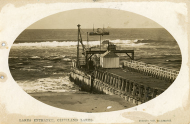 Lakes Entrance Historical Society
Postcard - Eastern Pier, Vogt, Stanley, 1910c
... of eastern pier at the entrance to Gippsland Lakes from ocean - Bass... from ocean - Bass Strait, at Lakes Entrance, Victoria. Photo ...Oval shaped picture. Also other copies, oval shaped 12.5 x 17.5 cm and 17.5 x 25 cm. Also two black and white prints 9 x 13 cm.Sepia postcard in cameo image, showing early view of eastern pier at the entrance to Gippsland Lakes from ocean - Bass Strait, at Lakes Entrance, Victoria. Photo shows work shed and crane at end of wooden eastern pier, SS Wyralla at sea.Lakes Entrance, Gippsland Lakes machinery, waterways, piers, ships and shipping -
 Lakes Entrance Historical Society
Photograph - The Entrance
... ocean - Bass Strait. Concrete extensions completed, kiosk next... photograph showing piers and entrance from ocean - Bass Strait ...Black and white photograph showing piers and entrance from ocean - Bass Strait. Concrete extensions completed, kiosk next to boardwalk. Appears to be cold day, few people about, wearing coats and sheltering behind tussocks, kiosk window half open.boardwalk, restaurant, waterways, beaches -
 Lakes Entrance Historical Society
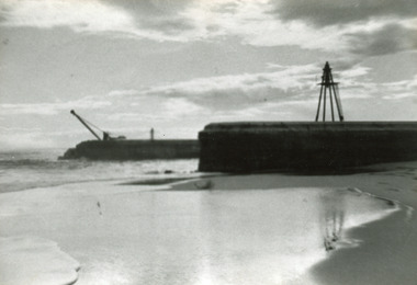
Photograph - Entrance Piers, 1917c
... to original piers at entrance to Gippsland Lakes from ocean Bass... ocean Bass Strait. Eastern pier in foreground finished, western ...Black and white photograph showing concrete extensions to original piers at entrance to Gippsland Lakes from ocean Bass Strait. Eastern pier in foreground finished, western pier in background not finished, crane still in use. Beach in foreground. Lakes Entrance Victoriapiers, waterways -
 Lakes Entrance Historical Society
Photograph - The Entrance, Calvert Barbara, 1960c
... Bass Strait to the Gippsland Lakes taken from Jemmys Point... of the man-made entrance from Bass Strait to the Gippsland Lakes ...Black and white photograph of the man-made entrance from Bass Strait to the Gippsland Lakes taken from Jemmys Point. It also shows the rock groynes at Bullock Island with dredged sand starting to fill the basins to enlarge the island. Lakes Entrance Victoriawaterways, public works -
 Lakes Entrance Historical Society
Photograph - The Entrance, 1920c
... Bass Strait to the Gippsland Lakes, taken from the road... of the man-made entrance from Bass Strait to the Gippsland Lakes ...Black and white photograph of the man-made entrance from Bass Strait to the Gippsland Lakes, taken from the road at Jemmys Point. It also shows the rock groynes at Bullock Island. A steamer is entering the lakes from Cunninghame Arm. Lakes Entrance Victoriawaterways, ships and shipping -
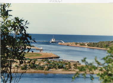
 Lakes Entrance Historical Society
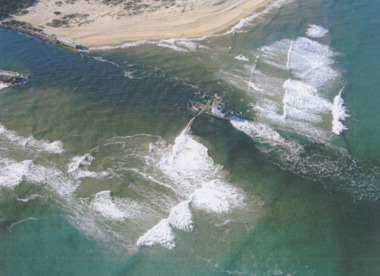
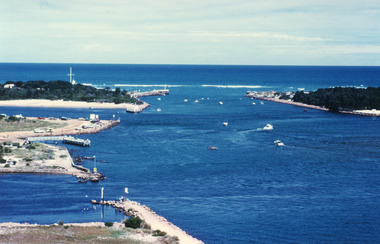
Photograph - Boat Harbour, Gippsland Ports, dredge April Hamer Lakes Entrance, 2006
... Colour aerial photograph of the Entrance from Bass Strait... of the Entrance from Bass Strait to the Gippsland Lakes showing rock ...Colour aerial photograph of the Entrance from Bass Strait to the Gippsland Lakes showing rock entrance groynes, surf on beach, dredge April Hamer working in the channel Lakes Entrance Victoria. Also another copy size 15 x 19.5 cmwaterways, topography, beaches, ocean -
 Orbost & District Historical Society
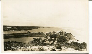
black and white photograph, C 1890s -1910
... to Bass Strait. The entrance changes location but remains open... to Bass Strait. The entrance changes location but remains open ...This is a photograph of the entrance of the Snowy River to Bass Strait. The entrance changes location but remains open for most of the year, although on occasions is closed by the prevailing weather and river water levels. In this photograph the entrance is quite wide and near the Marlo Hotel. This is a pictorial record of the Snowy River entrance at Marlo showing an open entrance.A black / white photograph / postcard of sandhills, river water on left and ocean on right. There is a group of buildings in the background - left. on front - "Snowy River Entrance Marlo"snowy-river-entrance marlo-snowy-river -
 Parks Victoria - Gabo Island Lightstation
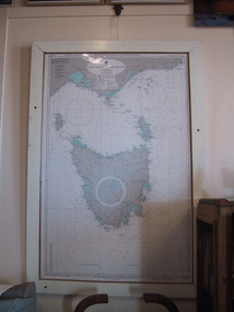
Chart, nautical, "Cape Otway to Gabo Island including Tasmania", April 1071
... in a wooden frame and covers Bass Strait between Cape Otway and Gabo... frame and covers Bass Strait between Cape Otway and Gabo Island ...This mounted chart, dated 21 August 1971 is under glass in a wooden frame and covers Bass Strait between Cape Otway and Gabo Island, showing southern and eastern Victoria and the whole of Tasmania. The frame was possibly handmade locally. The charts are specific to the Gabo Island Lightstation and have second level contributory significance for their historic value and provenance to the lightstation.Blue / grey & white nautical chart of Cape Otway to Gabo Island . It is under glass and in a white painted wooden frame. The frame has three holes at the top left and the base.Top left-hand," AUS 422 DEPTHS IN FATHOMS......." -
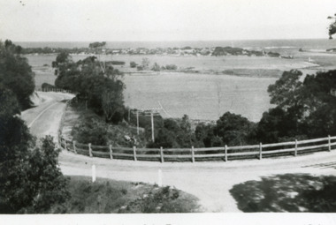
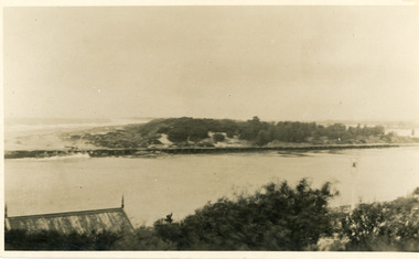
 Lakes Entrance Historical Society
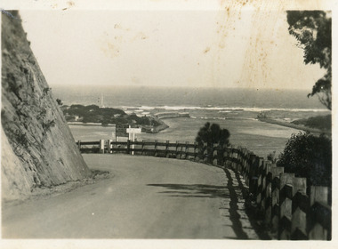
Postcard - The Entrance, Bulmer H.D, 1940c
... entrance from Bass Strait to Lakes system is in view. Lakes... guard fence. The artificial entrance from Bass Strait to Lakes ...Black and white small format postcard showing a bend in the Princes Highway on the Kalimna Hill. The road runs between the steep road cutting and post and rail guard fence. The artificial entrance from Bass Strait to Lakes system is in view. Lakes Entrance Victoriawaterways, islands -
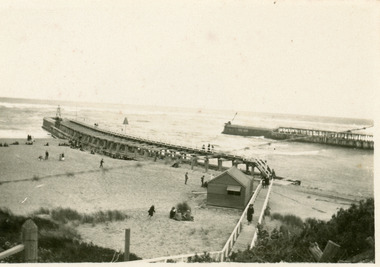
 Lakes Entrance Historical Society
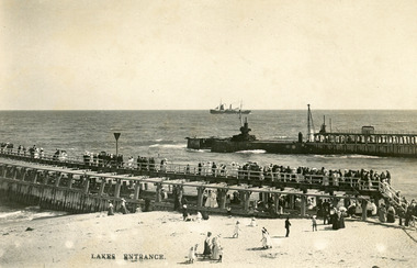
Photograph - Entrance Piers, Bulmer and Segerberg, 1910c
... to Gippsland Lakes from ocean Bass Strait. Crowd of people on eastern... to Gippsland Lakes from ocean Bass Strait. Crowd of people on eastern ...Black and white photograph showing piers and entrance to Gippsland Lakes from ocean Bass Strait. Crowd of people on eastern pier and beach. Concrete extension to western pier in progress, two cranes. Steam ship with sails out at sea. Lakes Entrance VictoriaLakes Entrancewaterways, boardwalk, ships and shipping, piers -
 Lakes Entrance Historical Society
Photograph - The Entrance, 1910c
... Lakes from ocean- Bass Strait, looking west towards Western Pier... showing view of entrance to Gippsland Lakes from ocean- Bass ...also copies|Two black and white 8.5 x 14|Two black and white 16 x 25Sepia photograph showing view of entrance to Gippsland Lakes from ocean- Bass Strait, looking west towards Western Pier and dunes. Foreground on left shows gable roof of rocket shed and shipwreck bell on white post on right. Lakes Entrance Victoriawaterways, sandbar, rocket shed -
 Lakes Entrance Historical Society
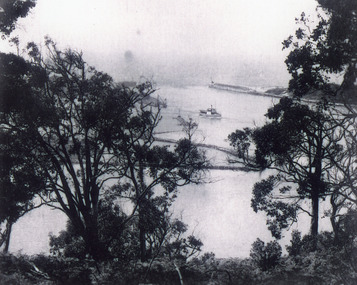
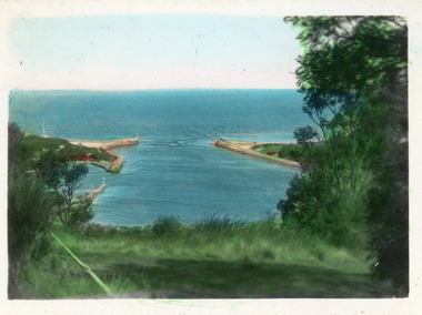
Photograph - The Entrance, 1945c
... Bass Strait to the Gippsland lakes, taken from Jemmys Point...-made entrance from Bass Strait to the Gippsland lakes, taken ...Other copiesHand tinted colour photograph of the man-made entrance from Bass Strait to the Gippsland lakes, taken from Jemmys Point. It also shows the rock groynes at the western end of Bullock Island, and at the entrances to Cunninghame Arm and the North Arm. Lakes Entrance VictoriaThe Entrance, Lakes Entranceislands, waterways, boats and boating -
 Lakes Entrance Historical Society
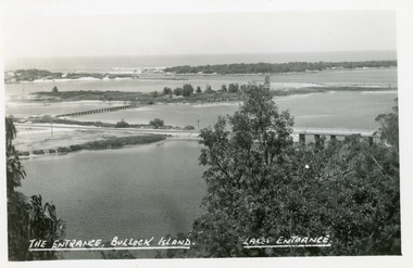
Photograph - The Entrance, Tambo Shire, 1990
... Bass Strait, dredge April Hamer working on the bar. Western... the entrance to the lakes from Bass Strait, dredge April Hamer working ...Colour photograph showing the entrance to the lakes from Bass Strait, dredge April Hamer working on the bar. Western spit on right, eastern spit hidden behind bush, Bullock Island on left centre, mouth of North Arm in foreground, Lakes Entrance, Victoria.waterways, islands, township -
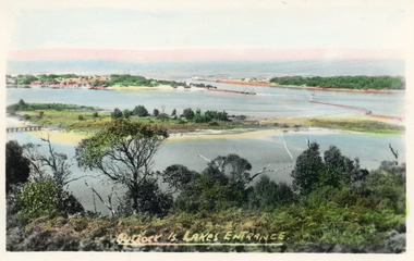 Lakes Entrance Historical Society
Postcard - Bullock Island, Bulmer H D, 1920c
... entrance from Bass Strait to the Gippsland Lakes. Also shown... entrance from Bass Strait to the Gippsland Lakes. Also shown ...Hand coloured postcard of Bullock Island and the man made entrance from Bass Strait to the Gippsland Lakes. Also shown the small township, unofficially known as Carpentertown at the entrance works. Photo taken from Kalimna Hill, shrubbery in foreground. Lakes Entrance VictoriaBullock Island, Lakes Entrancewaterways, bridges, islands, jetties -
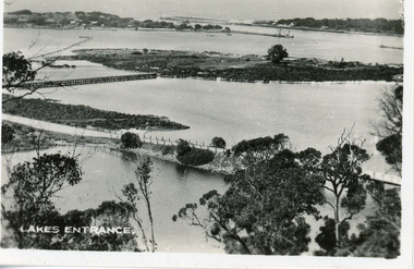
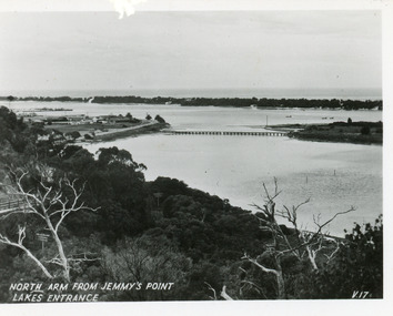 Lakes Entrance Historical Society
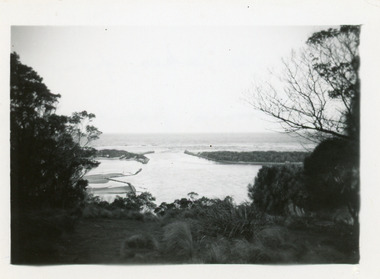
Postcard - North Arm, Valentine Series, 1930c
... covered hummocks and Bass Strait in distance. Lakes Entrance... to Bullock Island, scrub covered hummocks and Bass Strait in distance ...This is the before paired photograph used in the 150 year Lakes Entrance 1858-2008 display.|The after paired photograph number is 01590.1 Also one 12 x 16 framed photograph used in room display.Black and white small format postcard of North Arm and Cunninghame Arm of Gippsland Lakes, taken from Jemmys Point, Club Hotel at western end of town, bridge to Bullock Island, scrub covered hummocks and Bass Strait in distance. Lakes Entrance VictoriaNorth Arm from Jemmys Point Lakes Entrancebridges, islands, waterways, topography -
 Lakes Entrance Historical Society
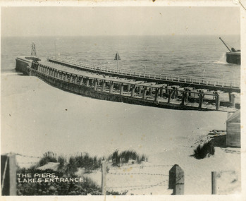
Postcard - The Entrance, Valentine Series, 1920c
... of western pier at entrance to Gippsland Lakes from ocean - Bass... of western pier at entrance to Gippsland Lakes from ocean - Bass ...One sepia copy 7 x 8.5 cm, also black and white copy 9 x 15 cm (Valentine Series)Small format postcard showing eastern pier and tip of western pier at entrance to Gippsland Lakes from ocean - Bass Strait at Lakes Entrance, Victoria. Side of kiosk on right hand side, beach in middle ground, post and barb wire fence lower foreground.The Piers Lakes Entrance waterways, piers -
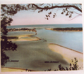
 Lakes Entrance Historical Society
Postcard - The Entrance, 1940
... from Bass Strait to the Gippsland Lakes taken from Jemmys Point... postcard of the man-made entrance from Bass Strait to the Gippsland ...Hand tinted small format postcard of the man-made entrance from Bass Strait to the Gippsland Lakes taken from Jemmys Point. It also shows the rock groynes at the entrance to Cunninghame Arm, and the grassy clearing atop Jemmys Point in the foreground. Lakes Entrance Victoriaislands, topography, waterways -
 Lakes Entrance Historical Society
Photograph - May 1944 rescue in Bass Strait, Lakes Post Newspaper, Kevin Horne, 1/10/1994 12:00:00 AM
... May 1944 rescue in Bass Strait... their plane went down in Bass Strait. Shown here on his visit to thank... in Bass Strait. Shown here on his visit to thank the remaining ...Also in rescue party Harold Broome and Vic CarstairsBlack and white photograph of Kevin Horne one of the four airmen rescued by fisherman Jack Gray and sons in May 1944 when their plane went down in Bass Strait. Shown here on his visit to thank the remaining members of the rescue party at Lakes Entrance Victoriamilitary history, people, r a a f, world war 1939 - 1945 -
 Lakes Entrance Historical Society
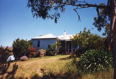
Photograph - Bunga Haven, 1999
... overlooking Lake Bunga and Bass Strait. Set in rustic garden... iron roof overlooking Lake Bunga and Bass Strait. Set in rustic ...Built on site of Northrope's original bark residence (1890c).Colour photograph of a property known as Bunga Haven at 127 Lake Bunga Road. A timber dwelling with corrugated iron roof overlooking Lake Bunga and Bass Strait. Set in rustic garden and native bushland. Dropped log boundary fence and brush gate. Lakes Entrance Victoriaaccommodation, tourism -
 Lakes Entrance Historical Society
Photograph - The Entrance, Fraser Ian, 1995c
... Colour photograph of the entrance from Bass Strait... photograph of the entrance from Bass Strait to the Gippsland Lakes ...Colour photograph of the entrance from Bass Strait to the Gippsland Lakes. It shows the western end of Bullock Island and the entrance to North Arm, cars parked on island and many people fishing. This area built up during dredging operations over many years. Lakes Entrance Victoria topography, fishing industry, boats and boating -
 Lakes Entrance Historical Society
Postcard - Bullock Island, The Lakes Studio, 1920c
... Island and foot bridge northern end of piers at entrance to Bass... bridge northern end of piers at entrance to Bass Strait and sand ...One black and white copy 17 x 25Black and white postcard showing North Arm Bridge, Bullock Island and foot bridge northern end of piers at entrance to Bass Strait and sand dunes. Left foreground shows power pole and water bore and telephone poles along Princes Highway Lakes Entrance Victoria.The Entrance, Bullock Island, Lakes Entranceislands, bridges, waterways, topography -
 Lakes Entrance Historical Society
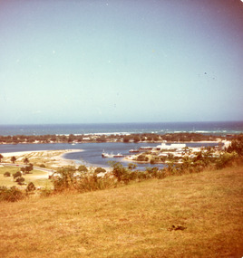
Photograph - Bullock Island, Fraser Ian, 1975c
... and Bass Strait in distance. Taken from Seaview Parade Kalimna... Hotel has been sown with grass, hummocks and Bass Strait ...Color photograph of the eastern part of Bullock Island, showing buildings of Lakes Entrance Fishing Co-Operative and PWD, spit opposite Club Hotel has been sown with grass, hummocks and Bass Strait in distance. Taken from Seaview Parade Kalimna. Lakes Entrance Victoriawaterways, islands, land reclamation, topography -
 Greensborough Historical Society
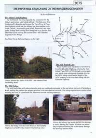
Article, Journal, Keith Patterson, The Paper Mill branch line on the Hurstbridge Railway, by Kevin Patterson, 2012_12
... by Bass Strait oil. ... changed to power by Bass Strait oil. husrstbridge railway line ...A branch line from the Outer Circle Line was built for the delivery of coal and paper pulp to the Australian Paper Mill at Fairfield. It operated as a branch from the Hurstbridge line until the 1970s, when the Australian Paper Mill plant changed to power by Bass Strait oil. 3 p., text , map and coloured photographs, pp. 4-6 of Nillumbik Custodian December (?) 2012husrstbridge railway line, outer circle railway line, australian paper mill -
 Lakes Entrance Historical Society
Photograph - The Entrance
... photograph showing entrance from ocean - Bass Strait... showing entrance from ocean - Bass Strait into Gippsland Lakes ...photograph showing entrance from ocean - Bass Strait into Gippsland Lakes , western pier on left side shows timber structure , tramline and crane . North end of eastern pier on right shows workshed and travelling crane and rubble wall. Mt Barkley in background Lakes Entrance Victoriawaterways, boats and boating, piers, topography -
 Lakes Entrance Historical Society
Photograph - The Entrance, 1920c
... to Gippsland Lakes from ocean - Bass Strait. Eastern pier on left, dune... stone piers at entrance to Gippsland Lakes from ocean - Bass ...Copied from photograph in possession of J WhadcoatBlack and white photograph showing stone piers at entrance to Gippsland Lakes from ocean - Bass Strait. Eastern pier on left, dune and western pier on right. Cranes and some work sheds on left. Navigation light on tip of Bullock Island on extreme right. Lakes Entrance Victoriajetties, waterways, topography, township -
 Orbost & District Historical Society
black and white photograph, late 19th - early 20th century
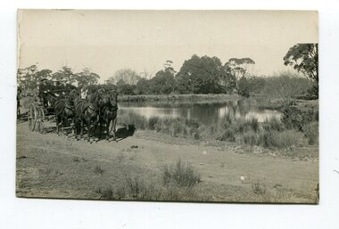
... South Wales. It flows into Bass Strait at Marlo in Victoria... South Wales. It flows into Bass Strait at Marlo in Victoria ...This photograph was taken at the junction of the Snowy and Brodribb Rivers. The Snowy River starts in New South Wales on the slopes of Mt Kosciuszko, Australia’s highest mountain, in New South Wales. It flows into Bass Strait at Marlo in Victoria. The Brodribb River is a tributary of the Snowy which enters the estuary at Marlo. This is a pictorial record of a road in Marlo near Orbost in the late 19th-early 20th centuries. It also depicts the transport used at that time.A black / white photograph of four men in suits seated in a horse - drawn buggy on a dirt road alongside a creek or river. There appears to be another horse - drawn vehicle behind them.on back - "at the Brodribb - Snowy junction. this road was corduroy (packed logs of tea trees?)brodribb-river snowy-river marlo transport-horse-drawn -
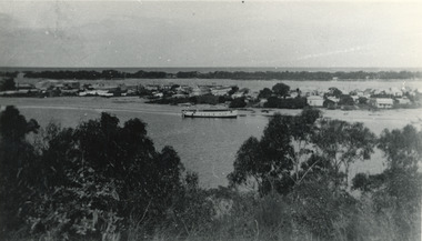 Lakes Entrance Historical Society
Photograph - Lakes Entrance, 1945 c
... to Bass Strait. Hulk of old Baang Yarnda moored in North Arm..., Cunninghame Arm and sand dunes out to Bass Strait. Hulk of old Baang ...The Hulk of the Baang Yarnda on the North Arm foreshore. (Note in album)Black and white photograph showing view from Kalimna cliff overlooking North Arm and township, Cunninghame Arm and sand dunes out to Bass Strait. Hulk of old Baang Yarnda moored in North Arm, towed there in 1939 and left to rot. Thick vegetation in foreground. Lakes Entrance Victoria.township, waterways -
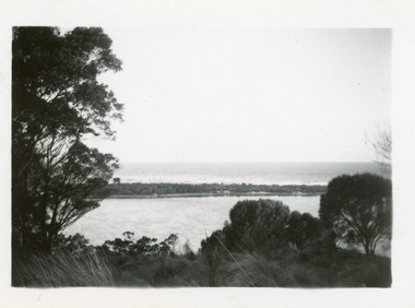 Lakes Entrance Historical Society
Photograph - Hopetoun Channel, 1950c
... on shore. Bass Strait beyond dunes, trees and shrubbery.... Schnapper Cottage just visible on shore. Bass Strait beyond dunes ...Black and white photograph showing sand dunes and Hopetoun Channel, Lakes Entrance, Victoria. Sand dunes near entrance Western Pier, hidden by trees. Schnapper Cottage just visible on shore. Bass Strait beyond dunes, trees and shrubbery in foreground Jemmys Point. Lakes Entrance Victoriaislands, topography, waterways