Showing 17183 items matching "bay-bridge"
-
 Ballarat Heritage Services
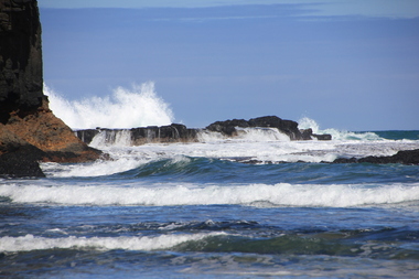
Digital photographs, L.J. Gervasoni, Bushrangers Bay, 2016
coast, coastal, coastal geomorphology, geology, ocean, waves, bushrangers bay -
 Ballarat Heritage Services
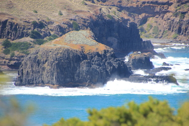
Digital photographs, L.J. Gervasoni, Elephant Rock Bushrangers Bay, 2016
coast, coastal, coastal geomorphology, geology, ocean, waves, bushrangers bay, elephant rock -
 Victorian Railway History Library
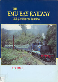
Book, Lou Rae, The Emu Bay Railway VDL Company to Pasminco, 1997
The history of the Emu Bay Railway Company in Tasmania from the Van Diemen's Land Company to the Pasminco company years.Index, bib, ill, maps, p.270.non-fictionThe history of the Emu Bay Railway Company in Tasmania from the Van Diemen's Land Company to the Pasminco company years.emu bay railway company., mineral industries -- tasmania -
 Ballarat Heritage Services
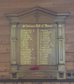
Photograph - Photograph - Colour, Clare Gervasoni, World War One Honour Roll in St Aiden's Anglican Church, Apollo Bay, 2022, 26/01/2020
Colour photograph of a timber war memorial.apollo bay, st aiden's anglican church, honour board, s.n. mitchell, f.j. lang, c.j. lang, w.j. vipont, c.a. telford, l.c. bailey, j. riley, a. wright, t. wright, s.t. gray, j.e. turner, h.j. goodwin, w.h. baldwin, h. mcg wilson, l.g. parker, c.r. mclennan, w.c. turner, w.a. kennedy, a.l. nichols, j. nichols, c.j. kennedy, l.a. cawood, j.j. currue, v.c. cawood, j.b. mcindoe, p.p. telford, s.g. currie, l.t. vipont, a.h. cawood, h. hamilton, m.v. brockfield, l.h. brockfield, r.a> brockfield, w.e. jones, t.t. jones, c. vipont, j. wright, c. varcoe -
 Australian Queer Archives
Magazine - Periodicals, Byronboys, Pink Guide Byron Bay & Tropical NSW, 2005
-
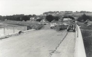 Phillip Island and District Historical Society Inc.
Photograph, Phillip Island Bridge, 1968/9
Construction of 2nd 1969 Bridge which was opened November 1969. From the Jack Jenner CollectionNew Bridge almost completed. San Remo in background with rising hill. Tractor on Bridge.local history, photographs, civil engineering, bridges, phillip island bridges, black & white photograph, jack jenner collection, public construction -
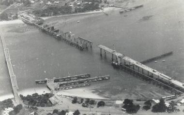
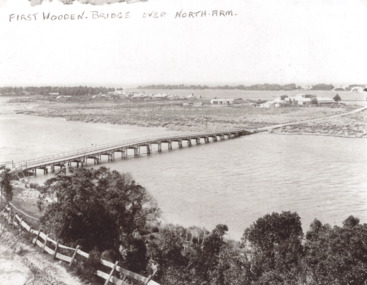 Lakes Entrance Historical Society
Photograph, Timber North Arm bridge, Lakes Entrance Victoria, 1900 c
Black and white photograph of the timber bridge over North Arm showing Club Hotel and guest houses facing front lake Lakes Entrance VictoriaFirst Wooden Bridge over North Armbridges, engineering, gippsland lakes -
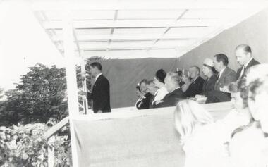 Phillip Island and District Historical Society Inc.
Photograph, Phillip Island Bridge Opening, 1969
Opening of 2nd Bridge. Speaker President Shire of Bass. This Bridge replaced the Suspension Bridge. From the Jack Jenner Collection.Opening of second Bridge 1969. Speaker, President, Shire of Basslocal history, photographs, civil engineering, bridges, opening of phillip island bridge, black & white photograph, jack jenner collection, phillip island bridges, public construction -
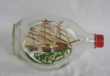 Greensborough Historical Society
Decorative object - Ship model in bottle, Ship models Robin Hood's Bay, "H.M.S. Bounty" 1784, 1950c
Ship model mounted in triangular Haig's whisky bottle. Model is based on "HMS Bounty". Display model, possible a souvenir, although these models can be made as a hobby.Ship model mounted in triangular Haig's whisky bottleShip model, Robin Hood's Bay, England label on screw top; John Haig & Co Ltd moulded on base; label with historical information on the Bounty pasted on bottlemodels, ship models, impossible bottle -
 Phillip Island and District Historical Society Inc.
Photograph, Phillip Island Bridge, 1968/9
Construction of 2nd 1968/69 Bridge connecting San Remo with Newhaven. From the Jack Jenner CollectionPhotograph showing two Bridges. Old Suspension Bridge on left. 1969 Bridge with all pillars in and decking completed only in foreground - taken from San Remolocal history, photographs, civil engineering, bridges, phillip island bridges, black & white photograph, jack jenner collection, public construction -
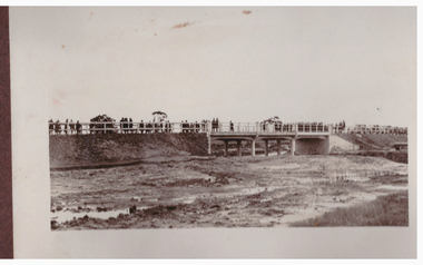 Linton and District Historical Society Inc
Photograph, Bridge Opening
Part of photograph album donated by Mrs Faull. The picture shows the opening of the Glenelg Highway Bridge over the Woady Yaloak Creek between Linton and Scarsdale.Black and white photograph of bridge opening. Bridge in background with people and cars.events, bridge openings, faull collection, woady yaloak creek -
 Falls Creek Historical Society
Photograph - Dick Stericker & Hans Fisher building bridge 1961
This item is from the private collection of George Shirling of Red Onion, Falls Creek. It depicts Dick Stericker & Hans Fisher constructing a wooden bridge. They both arrived in Falls Creek in the early 1960s. Hans worked on the slopes in summer and in winter, including building access bridges over the race-line as shown in this photograph. In 1965 Hans started as the chef Koki Alpine Lodge owned by George Shirling. He later worked as cook at various Falls Creek eating houses, as well as working for the lift company and slope maintenance People like Hans made Falls Creek. He passed away at Noosa, Queensland on 18th January 2022. George Shirling arrived in Falls Creek in 1962. He engaged Phil Nowell to build the original Koki Alpine Lodge which opened in 1965 with 14 beds. George operated the lodge with Michael “Baldy” Blackwell as manager. He also graduated in sport psychology in 1981 and was invited to become team psychologist for the Australian Winter Olympic team which went to Albertville, France, in 1992. He later owned the Red Onion Chalet. George credited the success of Koki to “Baldy” Blackwell. “Baldy” and Phil Nowell started the Trackers Mountain Lodge in partnership during the 1980s. In 1971 George sold Koki Lodge to Sigi Doerr. In 2024 the renamed Koki Alpine resort remains a highly popular destination in Falls Creek. George Shirling passed away on 27th February 2023. He had remained actively involved in Falls Creek and was generous with his time and knowledge, always an amazing supporter of The Falls Creek Museum and Falls Creek Village.This item is significant because it features two prominent members of the Falls Creek community.A black and white photograph of Dick Stericker & Hans Fisher taking a break whilst building a bridge. A typed George Shirling Collection number and description is attached. On label: ITEM NO. 148 Dick Stericker & Hans Fisher - smoko - while building bridge over raceline - Village T-bar, 1961george shirling, red onion, hans fisher -
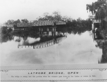 Lakes Entrance Historical Society
Photograph, Caire, Nicholas John, Swing Bridge Sale Victoria c1905, 1905c
Latrobe Bridge - Open. The bridge is swung into this position when the steamers pass down to the Lakes or return to Sale.Black and white photograph of the Latrobe River Bridge over the Latrobe River, shows the bridge open to river traffic, with a good view of the supporting structure. Sale Victoriawaterways, bridges, civil engineering -
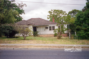 Eltham District Historical Society Inc
Photograph, Margaret Ball, 74 Bridge Street, Eltham, Nov-Dec 1999 now part of units 72-74 Bridge Street, 1999
The Margaret Ball (Pre 1960s Houses) Collection was a personal project initiated to mark the year 2000 and arose as a result of the disappearance of many pre-1960s parts of Eltham due to development. Approximately 200 pre-1960s style houses that were left in Eltham between Main Road and east to Bible Street, between Cecil Street to the north and south to Dalton Street were photographed in late 1999. Not all of the houses could be photographed; some because the garden or trees blocked the view of the house, others because of rubbish or cars were in the way, some because people were working on the house or in the gardens at the time.Roll of 35mm colour negative film, 7 stripsKodak GC 400-6eltham, houses, streets, margaret ball (pre 1960s houses) collection, bridge street -
 Sunbury Family History and Heritage Society Inc.
Photograph, Catanery Bridge, Bulla, c1980s
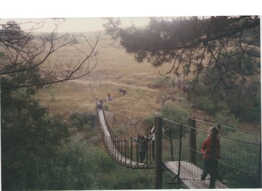
The narrow swing catanery bridge was built behind the school across the Deep Creek downstream from the bluestone Bulla Bridge. It was built so that children who lived on the south side of Bulla Township could access the school more easily and in shorter time than if they had to go by the main roads.The bridge was constructed in the days when most children walked to school. The use of this bridge cut the children's travel time and distance to school quite considerably and was used for many years until the school was closed in 1996.A coloured photograph of the children on a narrow swing bridge and the path they used to approach the bridge over open ground. bulla primary school, swing bridge, bridges, catanery bridge -
 Flagstaff Hill Maritime Museum and Village
Document - Navigation Chart, Admiralty Office, Lady Bay and Warrnambool Harbour, 1893
This navigation cart of Lady Bay and Warrnambool Harbour was originally surveyed in 1870 but this version includes the update for magnetic variation in 1893. Since the printing of the chart several annotations have been added. These include an additional stamp dated 15-8-1910, a handwritten comment across the top of the page dated August 1910, and another handwritten comment regarding the ‘Proposed Extension of Dock’ dated 19-2-1925, plus connected drawings, notes and figures. The 1925 proposal on this chart may have been a reaction to the Royal Commission of 1923, when the damaged stonework on the seaward side of the Warrnambool Breakwater, caused by the action of the sea, was the subject of enquiry. A conference between the Public Works, Water Commission and the Harbour Trust concluded that it would less costly to make repairs to prevent further damage rather than replaced the damage portion of the wall. A contract was raised in late 1924 to deposit rubble on the damaged side of the breakwater to minimise the Southern Ocean’s destructive action and work had started by August 1925. The Breakwater construction had begun in 1874 and was completed in 1890. The Victorian Government had commissioned Sir John Coode, a British harbour engineer, to present a plan to complete the Warrnambool Breakwater but his original plan was too expensive. He prepared a revised plan for a shorter structure. The construction proved to be too short to protect adequately from the weather and didn't allow enough depth for larger vessels to come into port. The decreasing trade was further affected by siltation in the bay due to the breakwater, and the completion of the railway line. The situation of the harbour became a real problem by 1910 and required continuous dredging. In 1914 the Breakwater was extended but proved to be a failure because the work began to subside and by 1920 about two thirds of the harbour was silted up. Alterations made in the 1920's increased the silting problem and by the 1940's the harbour was no longer used. More alterations were made in the 1950's and 1960's. This chart is significant for its strong connection to the maritime history of Warrnambool Harbour and Lady Bay and the Warrnambool Breakwater. The Warrnambool Breakwater is registered as a place of significance on the Victorian Heritage Database (VHR H2024). The Warrnambool Breakwater is one of the most important late 19th century maritime engineering projects in Victoria and significant in the development of Victorian coastal shipping. It is also significant for its connection with British harbour engineer, Sir John Coode. The chart is a historical record of structures existing in 1893; the Warrnambool Jetties, Warrnambool Breakwater in Lady Bay, the leading lights (lighthouses), streets, roads, bridges and many buildings. It also shows the lay of the land and seabed. Navigation Chart: Lady Bay and Warrnambool Harbour, Australia - South Coast - Victoria. Surveyed by Nav. Lieut. H.J. Stanley, R.N., 1870. Updated for Magnetic Variation, 1893. The rectangular chart is printed on heavy cream paper. Stamps are shaped rectangular, oval and round. Around the Breakwater and Jetty area are handwritten notes, dotted and joined lines, numbers and signatures, and shading of red and green. The chart shows the surrounds of Warrnambool Harbour, Lady Bay, the Breakwater and Jetty, roads, bridges and the streets in Warrnambool. It has sounding details, and angles of line from the leading lights.Stamp, rectangular, including "AUG 1910" Stamp, double oval " - - - -CHART" Stamp, hand drawn, red circle, with "B" inside Hand written note "22-8-1910 - - - - - of surveying C. Ca - - - request of 15-8-10 [initials] " Notes and lines in red pen, including a grid of sounding numbers: "1300" "1050" "1200" "Possible Extension of Dock" "19-2-25" "Dock Dredged to 20 Ft" Notes and lines in blue pen "Extension of Dock to accommodate vessels drawing 20 Feet" and "Light not visible south of this line" Red dots (4) with yellow highlight at both leading lights, breakwater and jettyflagstaff hill, warrnambool, flagstaff hill maritime museum & village, maritime museum, maritime village, shipwreck coast, map, chart, navigation chart, plan, lady bay, warrnambool harbour, port of warrnambool, breakwater, jetty, pier, dock extension, proposed extension, vhr h2024, 1870, 1893, 1910, 1925, warrnambool town late 1800s, warrnambool streets late 1800s royal commission, 1923, public works, water commission, harbour trust, victorian harbours, sir jon coode -
 Port Fairy Historical Society Museum and Archives
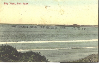
Photograph - Postcard, Bay view
Hand coloured Photograph/postcard of East beach showing ruins of the pier and in the background the lighthouse keeper's residenceBay Viewbeach, sea, seascape, postcard, east beach, light house keepers house, pier -
 Phillip Island and District Historical Society Inc.
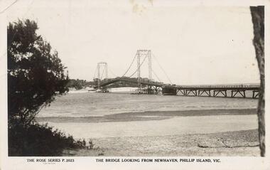
Photograph - Post Card, Suspension Bridge, 1940's
One of a collection of 18 photographs & postcards donated by Jill Yeoman. The Suspension Bridige was built during 1940. Postcard to Mrs Hughes & Lilly from Rita telling of a nice holiday visiting various towns and enjoying New Year's Eve fireworks on the Cowes beach.Black & White postcard of the Suspension Bridge from Newhaven, Phillip Island, to San Remo The Rose Series P. 2023. The bridge looking from Newhaven, Phillip Island, Vic.suspension bridge phillip island, phillip island bridge, jill yeoman -
 Peterborough History Group
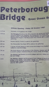
Pamphlet, Road Construction Authority, Peterborough Bridge, 1987
Printed to celebrate the official opening of the new bridge in 1987.The bridge across he river is a major access point and the old bridge had become decrepit and the construction of the new bridge was important. The official opening was a significant event.Pamphlet for the official opening of the new bridge in 1987. 2 A4 pages with a view of the old and new bridges, describing the construction of both.curdies river, great ocean road, bridges, peterborough, peterborough bridge -
 Ringwood and District Historical Society
Photograph, Deep Creek bridge and road c.1935
Black and white photograph of narrow unmade road showing narrow bridge with wooded balustrades. Forested area at edge of roadway.Typed below photograph, "Deep Creek bridge and road. c.1935". -
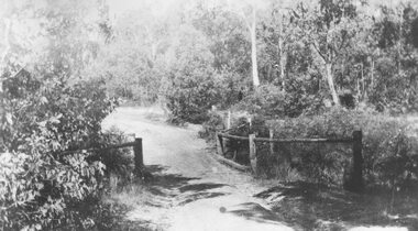
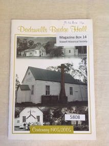 Stawell Historical Society Inc
Book, Rhonda Poholke, Dadswells Bridge Hall Centenary 1905/2005, 2005
A book commemerating the Centenary of the Dadswells Bridge HallWhite Card with lime green print and border enclosing five b/w photos of the Dadswells Brigde Hall.Dadswells Bridge Hall Centenary 1905-2005stawell -
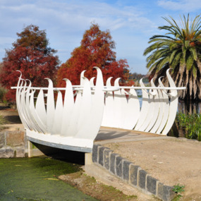 City of Ballarat
Artwork, other - Public Artwork, Swan Pool Bridge By Thomson Hay Landscape Architects, c2013
Swan Pool forms the southern gateway to the ‘Fairyland’ area on the western shore of Lake Wendouree, Ballarat. The new bridge was built c2013 and designed based on the form of water lily flowers. The sculptural form of the bridges enhances the ‘Fairyland’ experience for children and adults alike.white decorative steel bridge edgings -
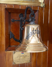 Mission to Seafarers Victoria
Equipment - Ship bell, Vickers, Barrow, SS Moreton Bay, 1920-1921
The Bell was presented to the Mission by the Aberdeen and Commonwealth Line in October 1957, after the ship made her final voyage to Australia in 1956 and it was broken up in Barrow in April 1957 by Thomas W Ward (UK). In the Annual Report 1957, Padre Oliver mentioned "the bell was found unsuited for the chapel belfry, it is to be mounted on a bracket and placed in the Celia Little lounge."Cast brass bell with wrought iron anchor and hook design wall mount: decoratively plaited cord in maritime knot pattern to resemble chain, sealed with a varnish and attached to cast iron clapper. Wrought iron hook secured by metal bolt. Bell is inscribed in upper case capital letters with MORETON BAY. Anchor attached with four flat headed hexagonal bolts with mighted wooden frame. Bell inscribed with upper case capital letters MORETON BAY. / Also brass presentation wall plaque (see image)bell, anchor, brass, ss moreton bay, ship's bell, plaque, celia little room, bracket, p&o, peninsular and oriental steam navigation company, passengers liners, passenger ships, emigrants, emigration -
 Victorian Interpretive Projects Inc.
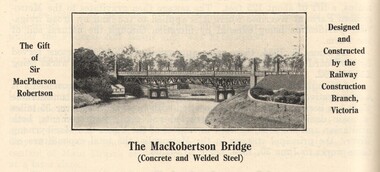
Image, MacRobertson's Bridge, 1934
Confectionery king MacPherson Robertson personally funded the £19 000 cost of the steel arch MacRobertson or Grange Road Bridge (1934) as a gift to Victoria for its centenary. (http://www.emelbourne.net.au/biogs/EM00234b.htm)A steel bridge over the Yarra River, Melbourne. The bridge was funded by MacPherson Robertson.macrobertson, bridge -
 Phillip Island and District Historical Society Inc.
Photograph, Phillip Island Bridge, 1968/9
1969 Bridge construction showing Suspension Bridge in background.Girders on partly built Bridge. Crane in background - close-up at low tide.local history, photographs, civil engineering, bridges, phillip island bridge (1969), black & white photograph, jack jenner collection, phillip island bridges, public construction -
 Kinglake Historical Society
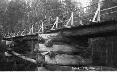
Log Bridge Kinglake
post card depicting horse and cart crossing log bridge at Kinglakeearly post card of Kinglake area including bridge and transportpost card of log bridge Kinglakekinglake, post card, log bridge, horse cart -
 Ballarat Heritage Services
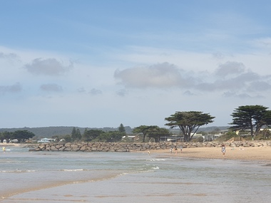
Photograph, Clare Gervasoni, Apollo Bay, Victoria, 24/01/2022
In 2021, the Department of Environment, Land, Water and Planning (DELWP) constructed two new groynes and a section of rock seawall at Apollo Bay to help manage the impacts of coastal erosion. The new 70-meter-long rock groynes run perpendicular to the shoreline and be located just south of the Milford St revetment and to the south of Milford Creek. Sections of rock seawall will be constructed between the two Groynes with an aim to protect the dune, walking path, cypress trees and road from erosion. Colour photograph of a coastal scene at Apollo Bay, featuring new rock groynes to protect the Great Ocean Road from erosion. apollo bay, beach, coast, groyne, rockwall -
 Linton and District Historical Society Inc
Photograph, Dilapidated bridge over Springdallah Creek, Happy Valley/Piggoreet, 2010
This bridge was built in the 1880s. By the 1980s it was in a dilapidated condition and was replaced. The old bridge was further damaged by storms and flooding in November 2010 and January 2011. (The newer bridge was completely washed away when the Springdallah Creek flooded in January 2011.) In 2025, little remains of the old bridge.Colour photograph of a trestle bridge spanning Springdallah Creek, Linton-Piggoreet Road.trestle bridges, old springdallah bridge -
 Ithacan Historical Society
Photograph, View of Exoghi and Afales Bay - Ithaca, c1970s
At an altitude of 340m, the picturesque village of Exogh in northern Ithaca, lies on the Homeric mountain of Neion. The village overlooks Aphales Bay and across the water the neighbouring island of Lefkada. During the Middle Ages and at the beginning of the Venetian rule, it was one of the most populated villages of the island, offering safety from the pirates, and an excellent view of the channel, the sea and the bays around the northern Ithaca.Some of the earliest Ithacan settlers in Melbourne were from the mountain village of Exoghi, including the founding president AJ.J. Lekatsas (Lucas). The village now has very few permanent residents with most having migrated or moved to the cities of Greece. A coloured photograph of a view overlooking the village of Exoghi and Aphales Bay on the island of Ithaca. The photograph was taken from the bell tower of the church of Panagias (the Virgin/Our Lady) sta Pernarakia located at the top of the mountain. The mountains which are visible across the skyline are the neighbouring island of Lefkada. mountain villages, ithaca -
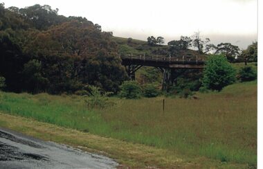
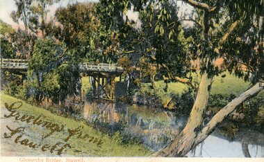 Stawell Historical Society Inc
Photograph, Greetings from Stawell - Glenorchy Bridge -- Postcard
Postcard Front - Glenorchy bridge over water with gums in colourGreetings from Stawell - Gold Pen. Bridge supports. Note from Mother. also gold pen. Also parts of trees