Showing 2120 items
matching bendigo maps
-
 Bendigo Historical Society Inc.
Map - PARISH OF HUNTLY(PART) AND SANDHURST(PART), No date visible
... Map: Part of parish plan of Bendigo, covering Strathdale... Inc. History House 11 Mackenzie Street Bendigo goldfields MAP ...Map: Part of parish plan of Bendigo, covering Strathdale, White Hills, Huntly and North Bendigo ( number 144 in Map Cupboard 1)map, bendigo, city streets, parish of hunlty, parish of sandhurst, strathdale, white hills, huntly, north bendigo -
 Bendigo Historical Society Inc.
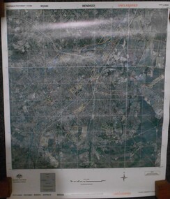
Map - BENDIGO AERIAL MAP 2007
... BENDIGO AERIAL MAP 2007...bendigo map...Aerial map of Bendigo 2007 printed on vinyl. Written...Aerial photo bendigo map Aerial map of Bendigo 2007 printed ...Aerial map of Bendigo 2007 printed on vinyl. Written on bottom of map ' Australian Government Department of Defence photomap Bendigo Australia WGS84.aerial photo, bendigo map -
 Bendigo Historical Society Inc.
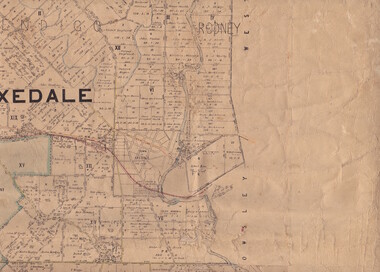
Map - Parish of Strathfieldsaye
... Shire of Strathfieldsaye County of Bendigo canvas backed...Map owned by Henry Thomas (Jack) Qualtrough who worked ...Map owned by Henry Thomas (Jack) Qualtrough who worked for the Victorian Forestry Commission. Shire of Strathfieldsaye County of Bendigo canvas backed map. L5169. Includes Axedale, Kimbolton, Eppalock and Sedgewick. Photographed/Lithographed for the Department of Lands and Survey Melbourne by T E McGauran 24.3.07. Price 1/-.map, axedale, kimbolton, sedgewick, eppalock -
 Bendigo Historical Society Inc.
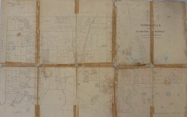
Map - JACK FLYNN MAP COLLECTION: GLADSTONE AND BENDIGO - TARNAGULLA, 13th May 1922
... JACK FLYNN MAP COLLECTION: GLADSTONE AND BENDIGO...Map 388. Counties of Gladstone and Bendigo a Map... Inc. History House 11 Mackenzie Street Bendigo goldfields MAP ...Map 388. Counties of Gladstone and Bendigo a Map of Tarnagulla with Kingower, Glenalbyn, Inglewood, Waanyarra and Laanecoorie boarding. The map is in poor condition and in several pieces. It has been previously taped together. The front page is of red card with white tape along the spine to hold it together, top half Tarnagulla is hand written in black lead on a label with blue trim.By Authority A.J. Mullett, Government Printer, Melbourne. Photo-Lithographed at the Department of Lands and Survey, Melbourne by W.J. Butson. 13.5.22map, bendigo, tarnagulla, tarnagulla, kingower, glenalbyn, laanecoorie, inglewood. -
 Bendigo Historical Society Inc.
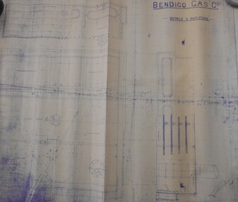
Map - BENDIGO WEEROONA GASWORKS MAP/PLAN COLLECTION: DETAILS FOUR PURIFIERS, 1889
... BENDIGO WEEROONA GASWORKS MAP/PLAN COLLECTION: DETAILS FOUR...Plan/map: Bendigo Weeroona Gaswork, plan showing details... Plan/map: Bendigo Weeroona Gaswork, plan showing details four ...Plan/map: Bendigo Weeroona Gaswork, plan showing details four purifiers. Plan signed by? Thompson engineer, dated 1889. Written on bottom RH: this is one of the drawings referred to in my contract dated ... (undated).plan, bendigo, bendigo weeroona gas works, gasworks, thompson -
Bendigo Historical Society Inc.
Map - SANDHURST (PART), Circa 1880's
... , Northwards from Lloyd St. East bendigo. ( number 212 in Map Cupboard... Inc. History House 11 Mackenzie Street Bendigo goldfields MAP ...Map: Parish plan showing a section of the city of Sandhurst, Northwards from Lloyd St. East bendigo. ( number 212 in Map Cupboard 1)map, bendigo, parish plan, lloyd st. sandhurst, bendigo -
 Bendigo Historical Society Inc.
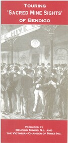
Book - TOURING 'SACRED MINE SIGHTS' OF BENDIGO, c1994
... of publication: Bendigo. 16 pages. Maps..... Maps. Book TOURING 'SACRED MINE SIGHTS' OF BENDIGO ...Touring 'Sacred Mine Sights' of Bendigo. Gold was discovered in 1851 and the mining era continued until 1954. Produced by Bendigo Mining NL and The Victorian Chamber of Mines Inc. Place of publication: Bendigo. 16 pages. Maps.David G Horsfallbendigo, mining, mining history guide for toursts, history bendigo mines locations -
 Bendigo Historical Society Inc.
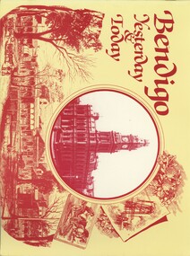
Book - BENDIGO YESTERDAY & TODAY, 1990
... Bendigo Yesterday & Today, 56 pages, published by Crown... maps & illustrations. Softcover. Book BENDIGO YESTERDAY & TODAY. ...Bendigo Yesterday & Today, 56 pages, published by Crown Castleton, containing black & white photographs of Bendigo, past & present plus maps & illustrations. Softcover.Ken Arnoldbendigo, buildings, heritage buildings, signed by author. -
 Bendigo Historical Society Inc.
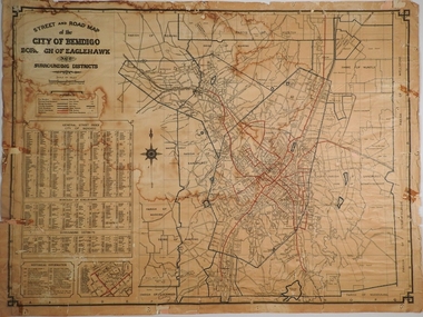
Map - CITY OF BENDIGO STREET AND ROAD MAP, 1946
... CITY OF BENDIGO STREET AND ROAD MAP...Map: City of Bendigo Street and road map, Incorporating...MAP Bendigo city streets Bendigo Streets Map: City ...Map: City of Bendigo Street and road map, Incorporating the Borough of Eaglehawk and surrounding Districts. Compiled by W.C Harry 1946, Examined by J. Harry 1946.map, bendigo, city streets, bendigo streets -
 Bendigo Historical Society Inc.
Map - FRIENDS OF WHITE HILLS CEMETERY COLLECTION: TWO MAPS
... Maps. Two maps of Bendigo Cemetery. (a) Bendigo Cemetery... Inc. History House 11 Mackenzie Street Bendigo goldfields MAP ...Maps. Two maps of Bendigo Cemetery. (a) Bendigo Cemetery produced by Bendigo Cemeteries Trust. (b) Bendigo Remembrance Park produced by Remembrance Parks Central Victoria.map, bendigo, bendigo cemetery and remembrance park -
Bendigo Historical Society Inc.
Map - BEAR'S LAGOON, 2/10/1931
... Map: Town of Munica ( name crossed out and Bear's Lagoon... Inc. History House 11 Mackenzie Street Bendigo goldfields MAP ...Map: Town of Munica ( name crossed out and Bear's Lagoon hand written in), Parish of Janiember east, County of Bendigo ( number 151 in Map Cupboard 1)map, bendigo, township, bear's lagoon, munica, janiember east, county of bendigo -
Bendigo Historical Society Inc.
Map - BENDIGO, issued 1st January 1906
... Map of Bendigo...Map: Sketch map of Bendigo, including Eaglehawk... Inc. History House 11 Mackenzie Street Bendigo goldfields MAP ...Map: Sketch map of Bendigo, including Eaglehawk and the Parish of Sandhurst. Issued by the Fire Underwriters Association of Victoria. Revised copy (number 317 in map cupboard 1)map, bendigo, city streets, map of bendigo, fire underwriters association of victoria -
 Bendigo Historical Society Inc.
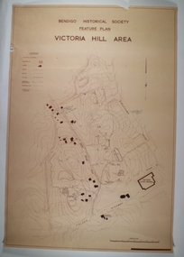
Map - VICTORIA HILL AREA, May 1971
... Map: Bendigo Historical Society feature plan. There are 3...MAP Bendigo mining plan Victoria Hill Bendigo Historical ...Map: Bendigo Historical Society feature plan. There are 3 of these plans, one is without feature names and one has several places highlighted in pencil. Compiled by AHQ Survey Regiment, CMF Increment ( number 181 in Map Cupboard 1)map, bendigo, mining plan, victoria hill, bendigo historical society, conrad heinze butchers -
 Bendigo Historical Society Inc.
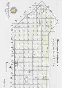
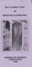
Document - BENDIGO CEMETERIES COLLECTION: SELF GUIDED TOUR WHITE HILLS CEMETERY DOCUMENT
... Hills Cemetery, Friends of Bendigo Cemeteries 1995. Map... of Bendigo Cemeteries 1995. Map with numbered grave sites e.g. Large ...BHS CollectionLilac coloured trifold document: Self guided tour of White Hills Cemetery, Friends of Bendigo Cemeteries 1995. Map with numbered grave sites e.g. Large Jewish section with over 80 known burials. Graves of Afghan traders,Friends of Bendigo Cemeteries, 1995bendigo, cemetery, white hills cemetery tour -
 Bendigo Historical Society Inc.
Book - JOAN O'SHEA COLLECTION: 150TH ANNIVERSARY OF BENDIGO BOOKLET, 1850 - 1950's
... of Bendigo: From Sheep Run to Provincial City in 100 years. Map... of Bendigo: From Sheep Run to Provincial City in 100 years. Map ...Joan O'Shea Collection. Buff Coloured Booklet City of Bendigo. 150th anniversary of Bendigo 1850s to 1950s. Image on cover coat of arms for City of Bendigo underneath word progress, left hand side horse, right hand side bullock. History of Bendigo: From Sheep Run to Provincial City in 100 years. Map of Bendigo and Surrounds Railways, Water Courses & Storage, Power, Municipal Boundaries & Land Available for Industry. Municipal District Creation 1855, Borough Proclamation 1863, Proclaimed City 1871, Area: 7992 Acres Population as of last census City of Bendigo 28,722, City of Bendigo and adjacent Urban Areas 36,909. City of Bendigo Map, The Past Prior to 1850. Icons of Bendigo The Bendigo base Hospital,Law Courts & Post Office, Primary Schools, Housing, Industry including Butter Production, Poultry Farming, Livestock Sales & Tomato Growing, Slaughter House & ordnance factory. The Present Recreation Photos: Bendigo Bowling Club, Queen Elizabeth Oval, Municipal Lawn Tennis Courts The Future of Bendigo, Bendigo Photographs From The 1950s,Cambridge Press Bendigobendigo, history, progress of bendigo 1850s on. -
Bendigo Historical Society Inc.
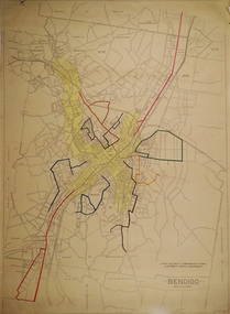
Map - GEOLOGICAL MAP: BENDIGO GOLD FIELDS
... GEOLOGICAL MAP: BENDIGO GOLD FIELDS...GEOLOGICAL MAP - BENDIGO GOLD FIELDS - Donated by JOHN... GOLDFIELDS Victorian Minister of Mines GEOLOGICAL MAP - BENDIGO GOLD ...GEOLOGICAL MAP - BENDIGO GOLD FIELDS - Donated by JOHN HORWOOD. Two geological maps of the Bendigo Gold fields. The maps display , reef lines, Hills, Dams and mine locations. Also Anticlines, sinclines, shafts, alluvial deposits, contours and gullys. All items are superimposed on a map of the major roads and streets of Bendigo. The maps were printed by The Victorian Minister for Mines in 1923 and re-issued in 1936. The maps have been specifically framed and donated to The Bendigo Historical Society Inc. in May 2015 for display at Specimen Cottage. John had been a student at The School of Mines- Bendigo and found them useful as a student living in Bendigo. Prior to being framed , the maps have been kept rolled up in his home. Accession Number 309/15 Were on Display at Specimen Cottage 2015 - 2020. After all items removed from SC to the BRAC in 2021 the framed maps could not be located. Search ongoing. BP 2.3.2023Victorian Minister of Minesgoldfields -
 Bendigo Military Museum
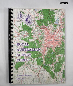
Administrative record - Royal Australian Survey Corps - Annual Report 1991 - 1992, Army Survey Regiment, 30 June 1992
... A4 Report, Part of Bendigo 1:100,000 map on the cover... Report, Part of Bendigo 1:100,000 map on the cover, Plastic ring ...This is a report on the status of Royal Australian Survey Corps mapping and charting and geodesy for the period 1 July 1991 to 30 June 1992A4 Report, Part of Bendigo 1:100,000 map on the cover, Plastic ring binder., gloss paper pages, plastic folders inside back cover containing Indexes of Mapping production and a momento of 50th Anniversary Army Survey Regiment ParadeSigned by Simon Lemon, Director of the Royal Australian Survey Corps - Armyroyal australian survey corps, rasvy, fortuna, army survey regiment, army svy regt, asr -
 Bendigo Historical Society Inc.
Map - FORTUNA HUSTLER'S MINE - PLAN OF THE FORTUNA HUSTLER'S MINE
... , Underground Survey Office Bendigo, September 1913. Map shows levels...MINING Parish Map Fortuna Hustler's Mine Plan ...Plan of the Fortuna Hustler's Mine, Bulletin No 33, Plate No II. Geological Survey of Victoria. Signed by H A Whitelaw, Underground Survey Office Bendigo, September 1913. Map shows levels and depths. There are smaller drawings of some sections of some levels. mining, parish map, fortuna hustler's mine, plan of the fortuna hustler's mine, geological survey of victoria, h a whitelaw, underground survey office bendigo -
 Bendigo Historical Society Inc.
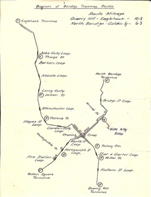
Document - BASIL MILLER COLLECTION: TRAMS - DIAGRAM BENDIGO TRAMWAY ROUTES
... Hand drawn map of Bendigo tramway Routes indicating... PERSON Individual basil miller Hand drawn map of Bendigo tramway ...Hand drawn map of Bendigo tramway Routes indicating location of loops and where lines terminated. Reverse: Bottom left corner 31/2 handwritten in blue ink.person, individual, basil miller -
Bendigo Historical Society Inc.
Map - SERPENTINE, No date Visible
... , County of Bendigo ( number 156 in Map Cupboard 1)... Inc. History House 11 Mackenzie Street Bendigo goldfields MAP ...Map: Township of Janiember (name crossed out and 'Serpentine' hand written in its place, Parish of Janiember east, County of Bendigo ( number 156 in Map Cupboard 1)map, bendigo, township, serpentine, janiember, parish of janiember east, county of bendigo -
 Bendigo Historical Society Inc.
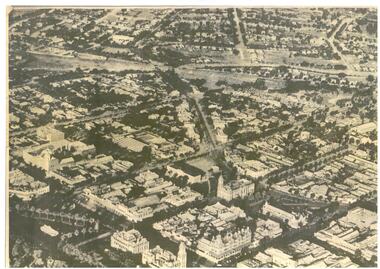
Map - BENDIGO MAP AERIAL VIEW, 1890s
... BENDIGO MAP AERIAL VIEW...Map of Bendigo. Aerial View of Bendigo. This aerial... PHOTOGRAPH Aerial bendigo Map of Bendigo. Aerial View of Bendigo ...Map of Bendigo. Aerial View of Bendigo. This aerial photograph was taken specially to mark the pccasion of the United Country party conference of 1936. Issued with the complements of 'The Argus' April 1936.photograph, aerial, bendigo -
 Bendigo Historical Society Inc.
Document - MCCOLL, RANKIN AND STANISTREET COLLECTION: INDENTURE, GOLD MINING LEASE CROWN AND RONALD ALEXANDER RANKIN, BENDIGO, 24th June 1941
... of Bendigo, dated 24th June, 1941. Map No. 11166 Bendigo, Mining... of Bendigo, dated 24th June, 1941. Map No. 11166 Bendigo, Mining ...6 page document, Gold Mining Lease 11166, plus map. Indenture between Crown (King George VI) and Ronald Alexander Rankin of Bendigo, dated 24th June, 1941. Map No. 11166 Bendigo, Mining District of Bendigo, Parish of Sandhurst, County of Bendigo. Map shows lease 11166 marked in yellow with shaft, ore bins and tramway marked. Belle Vue Road , Adam Street and Griston Street shown on map. ( Golden Gully area) Dams indicated on lease holdings. Other lease holdings: 1675 T.L.9858, 10990, 11013, 11062, 11165, 11063 (void) 1172 W.R. (dam thereon) 9882 (void). Some residential lots marked along Belle Vue Road, and Adam Street. On bottom of map 21.8.41 in pencil. On last page of document : North Deborah Mining Company now the proprietor of the within described estate by transfer registered on 11th November 1914.bendigo, mining, north deborah lease, belle vue road, adams street, griston street, golden gully, ronald alexander rankin, north deborah mine. -
 Bendigo Historical Society Inc.
Map - BENDIGO BUS ROUTES, 1934 - 1958 ?
... Map: Bendigo bus Routes, State Electricity Commission...MAP Bendigo transport State Electricity Commission Bendigo ...Map: Bendigo bus Routes, State Electricity Commission of Victoria, Electricity Supply Department. Printed on the bottom right hand corner F.E.B 23-12-47 , R.L.A. 5-9-58, 19-9-34, 27-11-37. 4 Mapsmap, bendigo, transport, state electricity commission, bendigo bus routes -
 Ballarat Tramway Museum
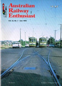
Magazine, William. F. Scott, "Australian Railway Enthusiast - Vol 32, No. 2, June 1994", Jun. 1994
... by the Bendigo Trust, maps and a list of the Bendigo Trust fleet. Front..., SEC takeover, closure, operation by the Bendigo Trust, maps ...Copy of the Australian Railway Enthusiast - Vol 32, No. 2, June 1994 which has an extensive photographic article on the Bendigo Tramways written by William F. Scott. Gives the origin of the city, first tramway, battery trams, steam trams, electrification, operation by ESCo, SEC takeover, closure, operation by the Bendigo Trust, maps and a list of the Bendigo Trust fleet. Front cover photograph of SEC cars 24 and 26 crossing on the Eaglehawk line.trams, tramways, bendigo, steam trams, battery trams, esco, sec, bendigo trust -
 Bendigo Historical Society Inc.
Document - MCCOLL, RANKIN AND STANISTREET COLLECTION: LEASE CONSENTS
... Virginia Gold Mining Co.);, 10370 Great Eastern (Bendigo), includes... Mining Co.);, 10370 Great Eastern (Bendigo), includes map; 10014 ...Manilla Folder containing correspondence and consents relating to the following Gold Mining Leases; 10819, 10027 (North Virginia Gold Mining Co.);, 10370 Great Eastern (Bendigo), includes map; 10014, South monument; 10059 North Neanger, with map; 10072 ; 10104; North Virginia; 10068 New Don Company with Map; 10032 New Balaclava, Whroo; 10026 East Clarence Gold M/C. Dated 1933 - 34gold mines, bendigo, gold mines, north virginia, great eastern, south monument, north neanger, new don, east clarence, new balaclava -
 Bendigo Historical Society Inc.
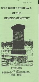
Document - BENDIGO CEMETERIES COLLECTION: SELF GUIDED TOUR NO. 5 DOCUMENT
... of the Bendigo Cemetery, Friends of the Bendigo Cemeteries 1998 - 1999...BHS Collection BENDIGO Cemetery bendigo cemetery tour ...BHS CollectionGreen trifold document: Self guided tour No. 5 of the Bendigo Cemetery, Friends of the Bendigo Cemeteries 1998 - 1999' Map of cemetery with numbered graves. Theme 'Heritage all around us'Friends of the Bendigo Cemetery 1998bendigo, cemetery, bendigo cemetery tour -
 Bendigo Historical Society Inc.
Document - INDENTURE, GOLD MINING LEASE 11081 CROWN AND HERBERT JACKSON LEED OF BENDIGO, MCCOLL, RANKIN AND STANISTREET COLLECTION, 21st September, 1940
... document. On map: Mining District of Bendigo, County of Bendigo... and ?Walsh, Warden Clerk, Bendigo. Map shows lease holding 11081 ...Six page document plus map, dated 21st September 1940, between the Crown and Herbert Jackson Leed, for the land shown on the accompanying map 'indicated by yellow colour' Depths indicated on lease document. On map: Mining District of Bendigo, County of Bendigo, Parish of Sandhurst. No. 11081. Net Area 24 acres, 3 roods, 3 perches. Signed by Herbert Leed and ?Walsh, Warden Clerk, Bendigo. Map shows lease holding 11081 coloured yellow. Other leases: no's. 9882 11081, 11034, 11080. Streets: Fletcher Street, and Belle Vue Road. Gullies: Derwenters Mistake Bully and Pig Face Gully on lease 11081. Quarry Hill Recreation Reserve marked and some residential allotments. Water race indicated on map. On back of document: ; Deborah United Gold Mining Company No Liability of Charing Cross Bendigo is now the proprietor of the within described estate by transfer registered on 21st November 1940 and numbered 1795202.bendigo, mining, deborah united gold mine, herbert jackson leed, deborah united gold mining. major general sir winston joseph dugan -
 Bendigo Historical Society Inc.
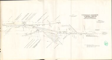
Document - BADHAM COLLECTION: VICTORIAN RAILWAYS MAP - NTH BENDIGO JUNCTION SIGNALLING DIAGRAM NO 4'80
... BADHAM COLLECTION: VICTORIAN RAILWAYS MAP - NTH BENDIGO...Victorian railways map: Nth Bendigo junction signalling... no 4'80 Victorian railways map: Nth Bendigo junction signalling ...Victorian railways map: Nth Bendigo junction signalling diagram no 480 showing signal and interlocking arrangements. Large paper map, A F chief electrical engineer 9.1.1980. Black ink diagram and writing.document, memo, railway, nth bendigo junction signalling diagram no 4'80 -
 Bendigo Historical Society Inc.
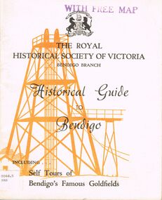
Book - HISTORICAL GUIDE TO BENDIGO
... Press, Bendigo 1968. photos, maps, illustrations. Two copies... Edition. Printed by Cambridge Press, Bendigo 1968. photos, maps ...Five copies of 'The Royal Historical Society of Victoria Bendigo Branch Historical Guide to Bendigo. Including Self Tours of Bendigo's Famous Goldfields.' Revised Edition. Printed by Cambridge Press, Bendigo 1968. photos, maps, illustrations. Two copies only have WITH FREE MAP stamped on the front cover.bendigo, history, gold mining, book, books, bendigo, history, royal historical society of victoria bendigo branch, gold, goldfields, victoria, victorian history, gold mines, gold, australian history, gold discoveries, mining. sticker bottom left front cover of two copies only 0064.5 par. 0064.6 par -
Bendigo Historical Society Inc.
Map - BENDIGO GOLD FIELD LONGITUDINAL VERTICAL PROJECTIONS
... Bendigo gold field map showing vertical projections... Survey Victoria Bendigo gold field map showing vertical ...Bendigo gold field map showing vertical projections of portions of three anticlinal axial planes showing stratigraphical zones and caps of known saddle reefs. This map forms part of the Geological Survey of Victoria, Structure of Bendigo Goldfield report, No. 47, 1923. H.Herman, late Director of Geological Survey.Geological Survey Victoriabendigo, gold mining, vertical projections, bendigo, goldfield, gold mining, reef lines, mining companies, geological survey