Showing 174 items
matching block court
-
 Surrey Hills Historical Society Collection
Photograph - 6 North Court, Surrey Hills, On The Street Where You Live Project
Photos documenting this address as part of a photographic series undertaken by volunteer photographers during 2013 and 2014 for The Street Where You Live Project. This was organised through the Surrey Hills Neighbourhood Centre and covered the postcode 3127 in the cities of Boroondara and Whitehorse.These photos provide a snapshot of real estate in the suburbs of Mont Albert and Surrey Hills during a period of rapid change with many properties on large blocks demolished to create higher density residential development or renewal of single dwellings. At particular risk were properties not covered by heritage overlays, especially interwar housing and post 1950's housing. -
 Surrey Hills Historical Society Collection
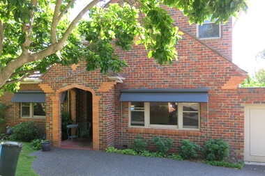
Photograph - 7 North Court, Surrey Hills, On The Street Where You Live Project
Photos documenting this address as part of a photographic series undertaken by volunteer photographers during 2013 and 2014 for The Street Where You Live Project. This was organised through the Surrey Hills Neighbourhood Centre and covered the postcode 3127 in the cities of Boroondara and Whitehorse.These photos provide a snapshot of real estate in the suburbs of Mont Albert and Surrey Hills during a period of rapid change with many properties on large blocks demolished to create higher density residential development or renewal of single dwellings. At particular risk were properties not covered by heritage overlays, especially interwar housing and post 1950's housing. -
 Surrey Hills Historical Society Collection
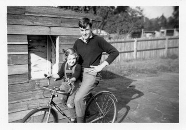
Digital photo, George Lister Coop with his sister Alison, c1950, c1950
The photo was taken at 688 Whitehorse Road, Mont Albert. It is of George Lister Coop (b1937) and his sister Alison (b1945). This was the home of 3 generations of the Coop family: 1. Josephine and George Frank Coop (noted in Box Hill Rate Books for 1947-1954). 2. George Burton Coop (1906-1960) and his family. He was Assistant Chief Architect of Victoria in the Public Works Department (P.W.D.) George Burton Coop was born in c1906 in Williamstown, the son of Josephine Vistarini and George Frank Coop. He married Winifred Alice Trewartha in 1936 and they are listed in the electoral rolls at 688 Whitehorse Road in 1937. George died 3/4/1960, aged 54 years at Mont Albert; Alice died in 1980. 3. George Burton and Alice Coop had 2 children: The donor George Lister Coop informed that the wooden shed was a cubby house built upon a degraded tennis court. He recalled that in his youth there were many private tennis courts in the area made possible by the generous size of the blocks of land. George initially attended Chatham State School because his first home was the Spanish Mission style flats at 346 Whitehorse Road, opposite Brenbeal Street, Balwyn. When his grandparents died, the family moved to 688 Whitehorse Road and he then attended Mont Albert Central School. Alison being younger did not go to Chatham Primary. A black & white photo of a teen-aged boy with a young girl on a bicycle in front of a timber shed on a degraded paved area. In the background is a paling fence with a strip of un-mown grass. Beyond the fence the outbuildings of the adjacent property can be seen. george lister coop, alison coop, bicycles, whitehorse road, surrey hills, children -
 Surrey Hills Historical Society Collection
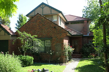
Photograph - 1 Laurencia Court, Mont Albert, The Street Where You Live Project
Photos documenting this address as part of a photographic series undertaken by volunteer photographers during 2013 and 2014 for The Street Where You Live Project. This was organised through the Surrey Hills Neighbourhood Centre and covered the postcode 3127 in the cities of Boroondara and Whitehorse.These photos provide a snapshot of real estate in the suburbs of Mont Albert and Surrey Hills during a period of rapid change with many properties on large blocks demolished to create higher density residential development or renewal of single dwellings. At particular risk were properties not covered by heritage overlays, especially interwar housing and post 1950's housing. -
 Surrey Hills Historical Society Collection
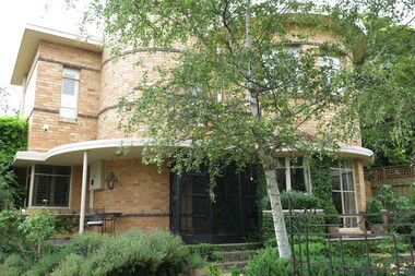
Photograph - 3A Laurencia Court, Mont Albert, The Street Where You Live Project
Photos documenting this address as part of a photographic series undertaken by volunteer photographers during 2013 and 2014 for The Street Where You Live Project. This was organised through the Surrey Hills Neighbourhood Centre and covered the postcode 3127 in the cities of Boroondara and Whitehorse.These photos provide a snapshot of real estate in the suburbs of Mont Albert and Surrey Hills during a period of rapid change with many properties on large blocks demolished to create higher density residential development or renewal of single dwellings. At particular risk were properties not covered by heritage overlays, especially interwar housing and post 1950's housing. -
 Surrey Hills Historical Society Collection
Photograph - 5 Laurencia Court, Mont Albert, The Street Where You Live Project
Photos documenting this address as part of a photographic series undertaken by volunteer photographers during 2013 and 2014 for The Street Where You Live Project. This was organised through the Surrey Hills Neighbourhood Centre and covered the postcode 3127 in the cities of Boroondara and Whitehorse.These photos provide a snapshot of real estate in the suburbs of Mont Albert and Surrey Hills during a period of rapid change with many properties on large blocks demolished to create higher density residential development or renewal of single dwellings. At particular risk were properties not covered by heritage overlays, especially interwar housing and post 1950's housing. -
 Surrey Hills Historical Society Collection
Photograph - 7 Laurencia Court, Mont Albert, The Street Where You Live Project
Photos documenting this address as part of a photographic series undertaken by volunteer photographers during 2013 and 2014 for The Street Where You Live Project. This was organised through the Surrey Hills Neighbourhood Centre and covered the postcode 3127 in the cities of Boroondara and Whitehorse.These photos provide a snapshot of real estate in the suburbs of Mont Albert and Surrey Hills during a period of rapid change with many properties on large blocks demolished to create higher density residential development or renewal of single dwellings. At particular risk were properties not covered by heritage overlays, especially interwar housing and post 1950's housing. -
 City of Greater Bendigo - Civic Collection
Newspaper, Shire of Marong, Upfront, c 1989
Marong was first incorporated as a road district on 27 August 1861, and became a shire on 23 December 1864. On 1 October 1915, the Borough of Raywood, which was gazetted on 17 January 1865 on 23.31 square kilometres of land 28 kilometres north of Bendigo was united with Marong. On 1 October 1990, the Shire of Marong became a rural city, under the Local Government Act 1989. In a report on 17 February 1994, the Local Government Board recommended that the five councils in the Bendigo region merge to form a "super city", with a population of about 81,000. Marong, Eaglehawk and Huntly had earlier objected to the proposal, and the Board noted a weak no vote against the merger proposal in a referendum in the region; about 70% had voted against, but with a turnout of between 30% and 40% of eligible voters. The three councils filed a writ in the Supreme Court, alleging failure to follow process by the Minister for Local Government, Roger Hallam, but by the time the new "super city" was announced, the writ had not yet been heard, and on 24 March 1994, the Rural City of Marong successfully applied for an injunction blocking the publication of the gazette the following day abolishing the five councils and appointing three commissioners. The government responded by introducing legislation, the City of Greater Bendigo Bill 1994, to Parliament, to effectively override the Supreme Court action, with Hallam saying "the bill would make clear that the Government is determined to achieve its objective for a more efficient municipal structure for the Bendigo region." Marong mayor Robert Hynes described the action as "terribly disappointing", adding, "One way or another, I believe it does mean an end to our fight... it seems the Government are above the law to me." On 6 April 1994, Marong voted to drop the Supreme Court action, effectively in doing so voting itself out of existence, and on 7 April 1994, the Rural City of Marong was abolished, and along with the City of Bendigo, the Borough of Eaglehawk and the Shires of Huntly and Strathfieldsaye, was merged into the newly created City of Greater Bendigo. On 29 April 1994, the Minister confirmed the Bill was not being proceeded with. https://en.wikipedia.org/wiki/Rural_City_of_MarongEight page newspaper style council newsletter providing community updates, news and information. shire of marong, city of greater bendigo amalgamation, councillor phillip eddy, rural city of marong -
 Melton City Libraries
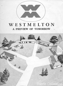
Document, West Melton: A preview of tomorrow, c.1969
"In April 1969, the first major residential development in Melton began with the release of 148 homes for purchase. This was the first stage of a staggered release of a planned 30,000 homes for 100,000 people by 1990. The development, called Westmelton Satellite City, was described as ‘a preview of tomorrow’.101 It was the first estate built in a ‘modern’ style, with curved streets, and dozens of culs de sac. Westmelton was also the first major development in Victoria to build all the supply lines to the houses – including electricity and telephone lines – underground. The six different home designs in Westmelton were ‘specially designed for the future’, and with allotments ten feet wider than regulations required, there was plenty of ‘space for gracious living’ and for a family swimming pool. The developers of this new estate were active in promoting Westmelton as a new community within the Shire of Melton. By 1971, the Westmelton City News reported that Ian McIntosh, General Manager of Westmelton, had given away $100,000 on behalf of the company ‘to aid community projects’. This included a $72,000 donation towards building a community centre in Westmelton, and $25,000 for the shire’s Olympic-sized swimming pool. Ian McIntosh and his family moved to Melton and Ian said he was ‘very much aware of the needs of [the] Westmelton community’. By the end of 1971, Westmelton was home to 100 new families. The modern residences were obviously an appealing drawcard, but so was the country feel that characterised Melton. Mrs C. Allen, described as a ‘housewife’, said she and her husband chose to move to Westmelton because of ‘the quality homes ... and we both love the clean, fresh, natural environment that surrounds us’. Similarly, Mr W. Coxhead, insurance consultant, moved to Westmelton because of the ‘clean, fresh country air’. Accountant Mr B. Swanton echoed their sentiments, describing Westmelton as ‘far enough away from the industrial pollution carried over Melbourne suburbs by prevailing westerly winds’. The new development attracted an increasing number of young, professional couples and families, representing the beginning of a significant shift from the predominantly rural and farming community of the district’s past. The Westmelton development had four different ‘neighbourhoods’ designed to cater to a variety of different lifestyle needs. Westmelton was the first to be established, followed by Brookfield, which offered ‘superb land in a rustic setting’. Brookfield Acres offered ‘wide open spaces with lots of room for a pool and even a tennis court’ on huge one-acre blocks, while Westlake was an innovative development with ‘different sized homesites’ and ‘lakeside living’.Westmelton was the first of many residential developments that would come to play a huge role in shaping the shire in the decades to follow".A marketing brochure for the Westmelton Satellite City developmentlocal significant events, council -
 Wodonga & District Historical Society Inc
Photograph - Codling Collection 01 - Wodonga's Second Police Station
Miss Olive Codling was a Foundation Member and a Life Member of the Wodonga Historical Society. Many of her prize-winning photos are held in the Society Collection. She also held a range of roles and committee positions in a wide range of Wodonga community organisations. WODONGA'S SECOND POLICE STATION - This building was located on the west side of High Street near the railway line at the corner of High Street and Bond Street. The building in the background was the Bond Store which was later repurposed to become the Court House. This Police Station, which began operation on this site c1905, had originally been the house of the customs officer. It had a front office and a Sergeant's and an Inspector's office as well as 2 barrack rooms and a laundry at the rear. In the backyard was a blue stone cell block and a night soil toilet, as well as a stable used previously for horse and carriage. Opposite the police station was a boarding house which supplied meals to prisoners. This police station was in use until its move to Elgin Street, Wodonga in December 1967.This photo collection is significant as it documents how the businesses and buildings in Wodonga have evolved and contributed to community throughout the 20th century.Two black and white photos of the 2nd Police Station built in Wodonga with the former Bond Store in the background.high st wodonga, police stations wodonga -
 Wodonga & District Historical Society Inc
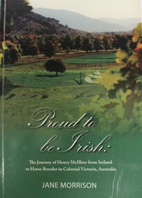
Book - Proud to be Irish: The Journey of Henry McIllree from Ireland to Horse Breeder in Colonial Victoria, Australia, Jane Morrison, 2019
Born in Belturbet, County Cavan, Ireland in 1824, McIllree was the youngest son of a large family. He achieved much after running away from home, aged just 14, to escape being sent into penury as a clergyman. By the time of his untimely death at Wodonga in 1882, McIllree had packed a lot into his life. He had sailed the high seas as an Able Seaman, toiled as a miner, run the Wodonga pound for 19 years, bought town blocks, set up a farm, a vineyard and a short- lived butchery business, served on local boards, appeared in court, leased and bought Upper Murray grazing lands, established a horse and cattle breeding enterprise at Biggara, taken horses to India for sale, and visited Aotearoa/ New Zealand’s Rotorua spas for a heart disease cure. Perhaps the most important even in his life was marrying a young Irish girl, Isabella Johnston from Belfast, at Wodonga in 1855. Their marriage produced 11 children, seven of whom have descendants living in Australia, Europe, Indonesia, Kiribati, the Philippines, and the United States of America.non-fictionBorn in Belturbet, County Cavan, Ireland in 1824, McIllree was the youngest son of a large family. He achieved much after running away from home, aged just 14, to escape being sent into penury as a clergyman. By the time of his untimely death at Wodonga in 1882, McIllree had packed a lot into his life. He had sailed the high seas as an Able Seaman, toiled as a miner, run the Wodonga pound for 19 years, bought town blocks, set up a farm, a vineyard and a short- lived butchery business, served on local boards, appeared in court, leased and bought Upper Murray grazing lands, established a horse and cattle breeding enterprise at Biggara, taken horses to India for sale, and visited Aotearoa/ New Zealand’s Rotorua spas for a heart disease cure. Perhaps the most important even in his life was marrying a young Irish girl, Isabella Johnston from Belfast, at Wodonga in 1855. Their marriage produced 11 children, seven of whom have descendants living in Australia, Europe, Indonesia, Kiribati, the Philippines, and the United States of America.henry mcillree, irish immigration, mcillree genealogy, wodonga pioneers -
 City of Kingston
Photograph - Colour, 6 March 1993
Edithvale is a suburb in the City of Kingston. It is located between Aspendale and Chelsea on the Port Phillip Bay and built within remnant areas of the Carrum Carrum swamp. The foreshore precinct comprises a wide sandy beach, with low sand dunes and numerous historic boat sheds. The suburb consists of older style dwellings and former holiday houses, combined with mid-century housing and newer homes. The large blocks are increasingly subdivided and the existing dwellings demolished to accommodate units and townhouses, thus changing the landscape of the area and reducing the tree canopy.The beachside suburb of Edithvale was previously part of the extensive Carrum Carrum Swamp. The area was once a source of fish and eels for the Mayone-Bulluk clan of the Bunurong people. Over time the area was drained and predominantly devoted to dairy farming and holiday houses. The farms were gradually sold and subdivided with a large number of homes built after World War II and in the 1960s. Edithvale is mainly residential with a shopping strip along Nepean Highway but little significant industry was ever established in the area apart from a plaster works and confectionary factory, both now closed.Laminated aerial colour photograph of Edithvale as viewed from Alexandra Avenue in the north to Ella Grove Chelsea/Edithvale in the south. regents Park Aspendale can be seen in the top left. The area is built-up with residential housing and facilities including Edithvale Primary School, numerous churches and the Edithvale Railway station. Large sections depict the remnant Carrum Carrum swamp. Edithvale Common and the former "Duck Inn" (Melbourne Water/Friends of Edithvale Seaford Wetlands) can be seen. Edithvale Recreational reserve, the valodrome and Edithvale Public Golf Course are prominent. The image shows vacant land in the area now known as Aspendale Gardens and the newer residential section of Chelsea Heights is not developed. A bike path has been established to cover the secondary drain. The Golf Links Court residential development located off Hughes Avenue is a large vacant block.Black type on white adhesive label: 6-3-93 Black type on white adhesive label: 25/9211, 6/3/93, 11.20 am Black type on white adhesive label: 9211 Yellow circular adhesive sticker Black pencil: 9211 6-3-93 arrow pointing Nedthvale, carrum carrum swamp, aspendale, chelsea -
 Melbourne Tram Museum
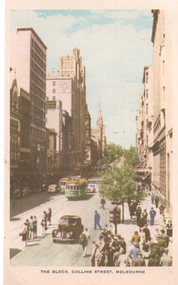
Postcard, Nucolorvue Publishing, "The Block Collins Street Melbourne", 1930s
Niucolorvue postcard titled "The Block Collins Street Melbourne", looking east from Elizabeth St. Has two W2 class trams in the view. As well as Kodak House, Howey Court, Manchester Unity building, and the Town Hall are in the background.Yields information about Collins St, during the 1930s.Postcard - printed, unused, coloured, by Nucolorvue Productions, Mentone Victoria.trams, tramways, w2 class, collins st -
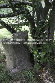 Eltham District Historical Society Inc
Photograph - Digital Photograph, Alan King, Heritage apple tree, 24 January 2008
This old apple tree situated beside the Plenty River Trail at Greensborough has been associated with Melbourne Founder John Batman. The concrete block is inscribed with the date 1841, when the tree was thought to have been planted. Known as Batman's Tree, this apple tree is on the bank of the Plenty River near Leischa Court, Greensborough. It is said that Melbourne Founder John Batman may have planted the tree and later signed his treaty here with the Aboriginal people. It still bears fruit and its recorded on the National Trust's Register of Significant Trees, as the oldest apple tree in Victoria. Published: Nillumbik Now and Then / Marguerite Marshall 2008; photographs Alan King with Marguerite Marshall.; p7This collection of almost 130 photos about places and people within the Shire of Nillumbik, an urban and rural municipality in Melbourne's north, contributes to an understanding of the history of the Shire. Published in 2008 immediately prior to the Black Saturday bushfires of February 7, 2009, it documents sites that were impacted, and in some cases destroyed by the fires. It includes photographs taken especially for the publication, creating a unique time capsule representing the Shire in the early 21st century. It remains the most recent comprehenesive publication devoted to the Shire's history connecting local residents to the past. nillumbik now and then (marshall-king) collection, greensborough, john batman tree, plenty river trail -
 Vision Australia
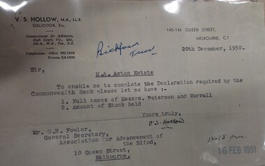
Letter - Text, Letter from V.S. Hollow to the Association for the Advancement of the Blind and reply, 20/12/1950
Letter reads as follows: Sir, M.A. Aston Estate To enable me to completed the Declaration required by the Commonwealth Bank please let me have: - 1. Full names of Messrs, Paterson and Worrall 2. Amount of stock held Yours truly, V.S. Hollow Handwritten in blue pen at top: Bickford Trust Handwritten in black pen at base: 12.15pm Stamped at base: 16 Feb 1951 A carbon copy of the response reads: 16th February 1951 Mr V.S. Hollow, M.A., LL.B., Solicitor 140 Queen Street Melbourne C1 Dear Sir, M.A. Aston Estate Your letter dated 20th December was hand delivered to me at 12.15 today. In answer thereto, I have to advise: 1. Mr Paterson is William Henry Paterson. Mr Worrall is Albert Victor Worrall. 2. The stock comprises two blocks 300 (pounds) and 200 (pounds) totalling 500 (pounds). Yours faithfully, General Secretary1 white page and 1 blue page (cc)In top left hand corner: V.S. Hollow, M.A., LL.B. Solicitor, etc. Commissioner for Affidavits, High Court, Vic., Qld., Sth A., W.A., Tas., NZ. Telephones: Office MU 1926, Private XA 1933 On the right hand corner: 140-146 Queen Street, Melbourne, C1association for the advancement of the blind, tilly aston -
 Southern Sherbrooke Historical Society Inc.
Photograph - Bert and Minnie Sutton c.mid 1940s
B&W photo of Bert (Gilbert William) and Minnie (Williamina Wilson) Sutton (daughter of Charles Macauley and Minnie Gray) standing outside their original home in Belgrave Heights. The photo shows the couple standing at their post-and-wire front fence at their property in Lockwood Road. The house was next door to Edward's store. Bert is in shirtsleeves and Minnie is wearing a cardigan over a dress. Their house is a single gabled house of weatherboard and fibro sheeting with an L-shaped open verandah. After purchasing the house Bert altered it, eventually enclosing the verandah and turning it into a sleepout. The house has been extensively altered since but is still standing in Lockwood Rd. The block is treed and the garden appears to be rather wild. A tiled roofed building is behind the house and to the left, possibly a garage. On the nature strip in front of the Suttons' house is a wooden bench, and attached to a tree are the signs, "Lockwood House" (with a hand pointing right), "To golf links" (with an arrow pointing right) and "Central Park Tennis Courts" (with an arrow pointing left). The sun is shining. Bert, who was a carpenter, died in 1969 and Minnie died in 1977. Copy of original photo donated to our society by Kath Oram, a founding member. -
 Bendigo Historical Society Inc.
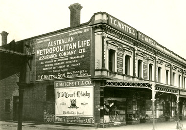
Photograph - MATCHETT'S CORNER
John Matchett was born in Corbrackey, Ireland in 1828. His Wholesale and Family Grocers started in 1857. It was on the Corner of Hargreaves and Edward Streets, Bendigo. It was known as the BELFAST STORES, HARGREAVES-STREET WEST SANDHURST. After his death in1903, Robert Matchett carried on the Grocery and Produce Business.Black and white photograph on grey board. Row of brick 2 storey shops with verandas over footpath. Windows on second story have columns each side and curved and painted pediments over. On back of photograph is written: Matchett's Corner at Bath Lane end of City Club Hotel. Block of buildings at Charing Cross. Demolished - replaced by Fountain Plaza block. In image, many advertisements. On F BR 'Frank A Jeffrey Photo - Bendigo'. Circular stamp 'Royal Historical Society of Victoria - Bendigo Branch'. In image 'TC Watts and Son' , 'Property and Furniture Auction Rooms', Australian - Metropolitan Life Assurance Company Ltd', R Matchett and Co - Grocers - Wine and Spirit Merchants', 'Old Court Whisky'. Pin hole in each corner, brown stain (spilled liquid) on image.Frank A Jeffreybendigo matchetts, john mattchett -
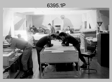 Bendigo Military Museum
Photograph - Army Survey Regiment – Map Production, Fortuna, Bendigo, 1986
These 17 photographs of the Army Survey Regiment’s map production and facilities were taken at Fortuna Villa, Bendigo, April 1986. Photos .1P to .3P were taken in Cartographic Squadron’s Correcting Section in the Attic. located on the top floor of Fortuna Photos .4P to .5P were taken in Cartographic Squadron’s Proving Section, located in the Ballroom also on the top floor facing the lake. The technicians were probably involved in a rapid response map production, as they all were wearing field uniforms. As ‘Regiment Overcrowding’ is annotated on the plastic sleeve holding the negatives, it seems the photos were taken when the unit was at its capacity to demonstrate the lack of suitable work areas. The Army Survey Regiment’s Duty Room, RAP and Carpark appearing in Photo .10P was probably taken from the top steps near the SGT’s accommodation block. Two of the photos in this set are also published in item 6096.5P.This is a set of 17 photograph of Map Production and car park was taken at the Army Survey Regiment, Fortuna, Bendigo, in April 1986. The black & white photographs are on 35mm negative film and are part of the Army Survey Regiment’s Collection. The photographs were scanned at 96 dpi. .1) - Photo, black & white, 1986. Correcting Section, Attic: L to R: CPL Andy Lucas, SPR Chris Gordon, unidentified, SPR Jan (Crighton) Minchin, CPL Robin Marshall, CPL Frank Downie, SPR Gayle Humphrey, unidentified (x2), Jason Wells at rear. .2) - Photo, black & white, 1986. Correcting Section, Attic: L to R: CPL Andy Lucas, SPR Chris Gordon, unidentified, SPR Jan (Crighton) Minchin, CPL Robin Marshall, CPL Frank Downie, SPR Gayle Humphrey, unidentified, Jason Wells, unidentified. .3) - Photo, black & white, 1986. Correcting Section, Attic: L to R: CPL Andy Lucas, CPL Robin Marshall, SPR Chris Gordon, unidentified, CPL Frank Downie, SPR Gayle Humphrey, unidentified, SPR Jan (Crighton) Minchin at rear., Jason Wells on phone. .4) & .5) - Photo, black & white, 1986. Proving Section, Ballroom: On left front to back: SGT Alan Staley, SGT Roger Rees, SGT Greg Anderson. On right front to back: SGT Denis McCarthy, SGT Tim Allanson, SSGT Adrian ‘Charlie’ Creedy. .6) - Photo, black & white, 1986. Records & Proofing buildings. .7) - Photo, black & white, 1986. Technical Services temporary buildings. .8) - Photo, black & white, 1986. Q-store and transport buildings. .9) - Photo, black & white, 1986. Technical Services temporary buildings in front of transport compound. .10) - Photo, black & white, 1986. Army Survey Regiment Duty Room, RAP and Carpark at Fortuna. .11) - Photo, black & white, 1986. Records & Proofing buildings. .12) - Photo, black & white, 1986. Other Ranks (OR’s) car park and barracks with kitchen in background. .13) - Photo, black & white, 1986. Other Ranks kitchen, parade ground and SGT’s/Officers barracks in background. .14) - Photo, black & white, 1986. Fortuna Villa taken from the steps near the SGT’s accommodation block. .15) - Photo, black & white, 1986. Fortuna Villa taken from the steps near the OR’s s accommodation block. .16) - Photo, black & white, 1986. Fortuna Villa taken from the roadway near the OR’s accommodation block. .17) - Photo, black & white, 1986. 20’ x 30’ Army tents set up on the basketball court..1P to .17P – ‘Regiment Overcrowding’ and the date are annotated on the plastic sleeve.royal australian survey corps, rasvy, army survey regiment, army svy regt, fortuna, asr -
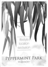 Ringwood and District Historical Society
Flyer, Residential Land Sale Brochure, Peppermint Park, Heathmont, Vic. - 2010
Double-sided A3 size advertisement for Peppermint Park, Heathmont, Victoria, advertising sale of ten homesites with diagram showing locality map, size of blocks and layout of streets within and around the subdivision.Subdivision layout includes Pleasant Drive, Swain Court and Barbara Court off Culverlands Road and Armstrong Road in Heathmont. Agents - Carter Real Estate Agency, 90 Maroondah Highway, Ringwood Vic 3134 (Telephone) 98706211. Auctioneers - Richard Carter & William Lyall - 0411823337. Handwritten price list notations included, and Stage 2 Plan digitally signed by Michael Herwald Hipfel, Licensed Surveyor, 10/2/1916. -
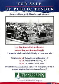 Port Melbourne Historical & Preservation Society
Flyer - Port Melbourne Courthouse, Frank Gordon and Co, For Sale by Public tender, 1998
... Police Police Station Court House Lockup Cell Block Frank Gordon ...A for Sale notice of 4 pages. Dark blue background. Header and photo of Port Melbourne Courthouse, Police Station and residence at 111 Bay Street. Inside pages have a map and pictures of the buidings, identified by Lots.built environment - civic, bay street, architecture, law, police, police station, court house, lockup, cell block, frank gordon & co -
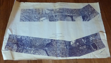 Melbourne Tram Museum
Drawing, Melbourne & Metropolitan Tramways Board (MMTB), Aerial photographs Bundoora Tram Extensions, Plenty Road – MMTB Drawings – 12/1979, Bundoora Extension – Metropolitan Transit Authority – 2/1983, John-Connell – Mott Hay and Anderson – Preliminary drawings for the Latrobe Modal Interchange – August 1984, 1979 to 1984
Set of drawings for the MMTB Plenty Road extension in 1979, MTA extension to Bundoora in 1983 and the Latrobe Uni Modal Interchange - 1984. Large print – Aerial photographs Bundoora Tram Extensions Stage 2 – Albert St to Kingsbury Drive Stage 3 – Kingsbury Drive to Settlement Road Has been rolled, left hand edge damaged, right hand edge torn Compiled by the ROW Division – 2/1981. Has written on rear at right hand end “Bundoora Tram Extension – Official MMTB Plans” 760H x 1190W Plenty Road – MMTB Drawings – 12/1979 P15123 Tyler St to Walsal Avenue P15124 Walsal Ave t McColl St P15125 McColl St to Dorrington Avenue Bundoora Extension – Metropolitan Transit Authority – 2/1983 P15400 Dorrington Avenue to Barwon Avenue P15401 Barwon Avenue to Nicholson Ave P15402 Nicholson St to Barling Park P15403 Barling Park to Darebin Creek P15404 Darebin Creek to Scott Grove P15405 Scott Grove to Clunes Street P15406 Clunes St to Cash St P15408 Cash St to Bundoora Park P15409 Bundoora Park to Larundel Hospital P15410 At Larundel Hospital P15411 Larundel Hospital to Marne Court P15412 Marne Court to Cherrywood Court P15413 Cherrywood Court to Morwell Ave P15414 Morwell Ave to Grimshaw St P15415 Grimshaw St to Nickson Street P15416 Nickson St to McLeans Road John-Connell – Mott Hay and Anderson – Preliminary drawings for the Latrobe Modal Interchange – August 1984. 8094-A-20 Set Out Plan and Paving Details 8094-A-21 Elevations 8094-A-22 Sections 8094-A-23 Roof Plan and Stormwater Layout 8094-A-24 Canopy Details 8094-A-25 Toilet Block and Waiting Room 8094-A-28 Miscellaneous DetailsOn rear of aerial photograph sheet - at right hand end “Bundoora Tram Extension – Official MMTB Plans” in felt pen.trams, tramways, plenty rd, bundoora, latrobe university, mmtb, construction, mta -
City of Kingston
Photograph - Colour, Circa 1993
Edithvale is a suburb in the City of Kingston. It is located between Aspendale and Chelsea on the Port Phillip Bay and built within remnant areas of the Carrum Carrum swamp. The foreshore precinct comprises a wide sandy beach, with low sand dunes and numerous historic boat sheds. The suburb consists of older style dwellings and former holiday houses, combined with mid-century housing and newer homes. The large blocks are increasingly subdivided and the existing dwellings demolished to accommodate units and townhouses, thus changing the landscape of the area and reducing the tree canopy.The beachside suburb of Edithvale was previously part of the extensive Carrum Carrum Swamp. The area was once a source of fish and eels for the Mayone-Bulluk clan of the Bunurong people. Over time the area was drained and predominantly devoted to dairy farming and holiday houses. The farms were gradually sold and subdivided with a large number of homes built after World War II and in the 1960s. Edithvale is mainly residential with a shopping strip along Nepean Highway but little significant industry was ever established in the area apart from a plaster works and confectionary factory, both now closed.Aerial colour photograph of Edithvale as viewed from Alexandra Avenue in the north to Ella Grove Chelsea/Edithvale in the south. The area is built-up with residential housing and facilities including Edithvale Primary School, numerous churches and the Edithvale Railway station. Large sections depict the remnant Carrum Carrum swamp. Edithvale Common and the former "Duck Inn" (Melbourne Water/Friends of Edithvale Seaford Wetlands) can be seen. Edithvale Recreational reserve, the velodrome and Edithvale Public Golf Course are prominent. The image shows vacant land in the area now known as Aspendale Gardens and the newer residential section of Chelsea Heights is not developed. A bike path has been established to cover the secondary drain. The Golf Links Court residential development located off Hughes Avenue is a large vacant block.Yellow circular adhesive sticker on plastic Black ink (marker): * (asterisk) Black type on white adhesive sticker: P000108edithvale, aspendale, chelsea, carrum carrum swamp -
Ballarat Heritage Services
Magazine - digital copy, Ballarat East high School Magazine 1959, 1959
Ballarat East High School was established in the early 1950s. This is one of the earliest magazines produced. School History: In February, 1955, Ballarat East High School opened in Hopetoun Street, in the vacated weatherboard buildings of the Girls’ Secondary School. In 1956, however, the School moved to its present site in Fussell Street, but because of the lack of space, Woodwork and Cookery classes were still held at Hopetoun Street. Since then there has been steady progress. The original building was extended, more classrooms and a library being built. A Domestic Science block was completed in 1957. Later, as mentioned elsewhere, sheltersheds, basketball courts, a bidycle shed and a canteen were provided for the pupils from funds raised by the Parents’ Association. Where there were previously bare areas of clayey soil we now have asphalt paths and neat gardens. Shrubs were planted, and seats, painted in the School colours, were places around the asphalted areas. (Page 5, 1959 BEHS School Magazine) 3 pdf files holding multiple pages of 1959 School Magazinebehs, ballarat east high school, ballarat east, magazine, 1959 -
 Bendigo Historical Society Inc.
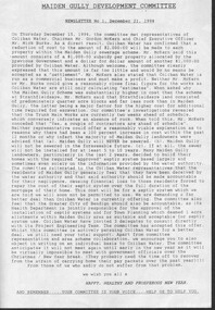
Document - Michele Matthews collection - paperwork and reports for re-zoning of Maiden Gully (1993 - 1996). Residents opposed the re-zoning as they had purchased land as "bush blocks", 25/02/2025
documents for Maiden Gully Sewerage SchemeMichele Matthews collection - paperwork and reports for re-zoning of Maiden Gully (1993 - 1996). Residents opposed the re-zoning as they had purchased land as "bush blocks" Coliban water Annual report 1993/94 21/12/1994 Maiden Gully Development Committee - newsletter No 1 - cttee met with representatives of Coliban Water Caliban Water information Bulletin January 1995 - Maiden Gully Sewerage Scheme 22/02/1995 Maiden Gully Development Committee - newsletter No 2 - cttee activities re the planned sewerage scheme 27/03/1995 - Coliban Water letter to WR & MS Matthews, owners 3 Clay Gully Court (Lot 56 LP 212245) undated - Maiden Gully Neighborhood Sewerage Schemes - Robin Hill Estate Scheme (cost allocation to property owners 21/04/1995 five-page letter of objection/complaint from WR & MS Matthews, owners 3 Clay Gully Court, re costs allocated against their property (Lot 56 LP 212245) 16/06/1995 five-page response from Coliban Water to WR & MS Matthews, owners 3 Clay Gully Court; regarding the outcome of their objection to the sewerage scheme 22/08/1995 letter from WR & MS Matthews, to resident re the results of their objections (and consequent concessions) from Coliban Water re the Robin Hill Estate Sept 1995 Maiden Gully Structure Plan, prepared by TEA planners & Planning Australia Consultants; provides a structure plan, for the Rural City of Marong, the propose future development of the Maiden Gully area Greater Bendigo Planning Scheme - Amendment L43 - Maiden Gully Township: * undated and author unstated - Maiden Gully questions sheet for residents re the proposed Maiden Gully Structure Plan - seven questions and answers * Fauna species - observed /recorded site 6; Maiden Gully (off Pioneer drive) * Explanatory report, three pages * 1/11/1995 Notice of Amendment to a Planning Scheme * Greater Bendigo Planning Scheme, Chapter 6, Amendment L43 (five pages) December 1995 Coliban Water "In the Pipe line", Maiden Gully Region Community Newsletter No 2 - Halfway mark for Sewerage Scheme March 1996 Coliban Water "In the Pipe line", Maiden Gully Region Community Newsletter No 3 - Home stretch for new sewer scheme May 1996 Coliban Water "In the Pipe line", Maiden Gully Region Community Newsletter No 4 - New sewerage scheme comes in well under budget Undated - Maiden Gully Township - Amendment L43 - Panel Hearing report (31 pages) maiden gully, sewerage scheme