Showing 301 items matching "bridge section"
-
 Bendigo Historical Society Inc.
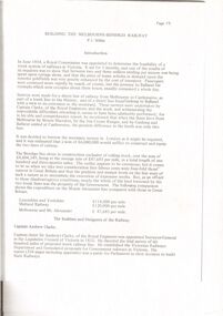
Document - BUILDING THE MELBOURNE TO BENDIGO RAILWAY
'BUILDING THE MELBOURNE-BENDIGO RAILWAY'' ( P J MILLAR). Copied from ??? With pages numbered from 19 to 42. Detailed coverage under sections: The builders and designers of the Railway; Some of the bridges along the line (viaducts and tunnels); Ordering of materials and plant; Transport of material; The strikes along the line; Riots on the line; Darbyshire's resignation; Conclusion. Includes 12 figures (poor quality reproduction photos and one map (Contracts for the Main Trunk Lines). One copy without stapling; oneP. J. Millarbendigo, history, bendigo railway, bendigo railway, j. p. millar, captain andrew clarke. -
 Bendigo Historical Society Inc.
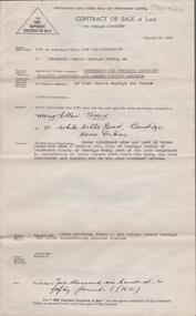
Document - H. A. & S. R. WILKINSON COLLECTION: CONTRACT OF SALE
Contract of sale of land dated 20th January, 1956 between Sandhurst & Northern District Trustees Executors& Agency (vendor) and Mrs. M. E. Taylor (purchaser). Property: land being Crown allotment 9 and part of Crown allotment 9A section 55C Parish of Sandhurst city of Bendigo, land described in certificate of title volume 4258 folio 516 land coloured red on the plan endorsed hereon, together with brick dwelling known as 199 Bridge Street, Bendigo. Price: 2,650 Pounds.organization, business, h.a. & s.r wilkinson real estate -
 Bendigo Historical Society Inc.
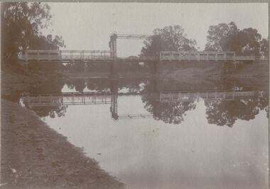
Photograph - BRIDGE - SINGLE SPAN
sepia photo on grey board: single span lift bridge across river. Long truss spans each side of lift section. Probably over Murray River ? On front rop right corner Mp 107. On back written ' copies obtainable from M. Clifton, Koondrook'M. Clifton ?bridge, construction, single span lift bridge -
 Port Melbourne Historical & Preservation Society
Plan - Pickles Street, Town of Emerald Hill and Borough of Sandridge, Sep 1881
Town of Emerald Hill and Borough of Sandridge plan for Pickles Street, including transverse and longitudinal sections - Spring to Graham. NB "bridge" near Liardet Street.Signed by Charles Clayengineering - roads streets lanes and footpaths, charles clay -
 Port Melbourne Historical & Preservation Society
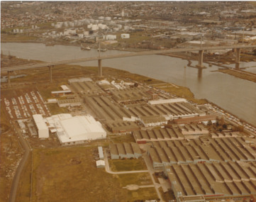
Photograph - Aerial view of West Gate Bridge under construction, 1970 - 1979
Colour aerial photograph of West Gate Bridge completed. Aircraft factory and other industry in foreground. Williamstown and fuel storage tanks in background (Coode Island)"Gov't A/C Factories Photographic Section Neg No N2841/3" stamped on backtransport, engineering, engineering - bridges, fishermans bend, industry, west gate bridge, rotten row, williamstown, yarra river -
Port Melbourne Historical & Preservation Society
Plan - Annotated and handcoloured by Peter Libbis to indicate his research into Libbis family residences and hotels on copy of a section of an MMBW map, Melbourne and Metropolitan Board of Works, c. 1980s
Peter LIBBIS obtained these copies from the MMBW when he researched his family history in the 1980s. He has annotated them, colour in hotels etc. Donated to Society in 1997.One of a group of 19 photocopies of various 20th century MMBW plans, annotated/coloured in to indicate residences of Libbis family and local hotels, by Peter LIBBIS in family and hotel research - Cricket ground, Bridge to Ingles - 1950s?business and traders - hotels, built environment - domestic, transport - railways, melbourne and metropolitan board of works, libbis family -
Port Melbourne Historical & Preservation Society
Plan - Heath Street, Bridge Street and Spring Street, Sandridge, 16 Mar 1868
Plan of Heath, Bridge, North and South Spring Streets 1868 showing Bay St, Raglan St,Spring St, and Nott St, labelled. Spring St North, Spring St South, Bridge St and Heath St unlabelled; and transverse sections of the streets with measurements.Signed "Peter Mackey, Nicholas Mackey 16/5/68" Other names have been crossed out with pencil.built environment - civic, engineering department - borough of sandridge, engineering - roads streets lanes and footpaths, heath street, bridge street, borough of sandridge -
Port Melbourne Historical & Preservation Society
Plan, J W Banks, Plans and Sections of Tramsway, Apr 1889
Large book of 9 pages, incl. title page, bound on left with black tape, wih plans and typeset descriptions of a proposal to run a cable tram under the Yarra from Williamstown to Melbourne (Falls Bridge) via Port Melbourne. Submitted to Victorian Legislative Assembly 1889Signed p. 2 by J.W. Banks, C.E.transport - tramways, town planning - proposals shelved, williamstown, j w banks -
Port Melbourne Historical & Preservation Society
Plan, A J Duncan, Draughtsman, Plans and Sections of Tramsway, May 1891
Plans and typeset descriptions of a proposal to run a cable tram under the Yarra from Williamstown to Melbourne (Falls Bridge) via Port Melbourne. Oriniginally submitted to Victorian Legislative Assembly 1889; this updated 1891 version has 10 pages, and includes an added section to take tramway to Sandridge Road as far as St. Kilda Road. A company has now formed to back the proposal being re-presented to the Legislative Assembly.Signed by Edward Clark 2-6-1891, with Borough stamp on cover; initialed, ditto, on page 2; signed by A.J. Duncan page 2.transport - tramways, town planning - proposals shelved, williamstown, edward clark, town clerks, mr jennings, austral - anglo tramway and general agency co ltd, a j duncan -
Port Melbourne Historical & Preservation Society
Plan, A J Duncan, Draughtsman, Plans and Sections of Tramsway, May 1891
Plans and typeset descriptions of a proposal to run a cable tram under the Yarra from Williamstown to Melbourne (Falls Bridge) via Port Melbourne. Oriniginally submitted to Victorian Legislative Assembly 1889; this updated 1891 version has 10 pages, and includes an added section to take tramway to Sandridge Road as far as St. Kilda Road. A company has now formed to back the proposal being re-presented to the Legislative Assembly. (Copy of 46.2)Signed by Edward Clark 2-6-1891, with Borough stamp on cover; initialed, ditto, on page 2; signed by A.J. Duncan page 2.transport - tramways, town planning - proposals shelved, williamstown, edward clark, town clerks, mr jennings, austral - anglo tramway and general agency co ltd, a j duncan -
Port Melbourne Historical & Preservation Society
Plan - Rouse Street footbridge, Borough of Sandridge, 6 Oct 1877
Elevation, ground plan and traverse section of Rouse Street footbridge. 1877.Samuel Carter (?) 6/10/1877. Edward Clark (Town Clerk) 6/10/1877.engineering - bridges, sandridge lagoon, edward clark, town clerks -
Port Melbourne Historical & Preservation Society
Photograph - Aerial view of Port Melbourne, 1931
Section of aerial photograph of Port Melbourne c1931 (refer item 574), covering Beach almost to Bridge Street and Lagoon to Bay Streetsandridge lagoon, built environment -
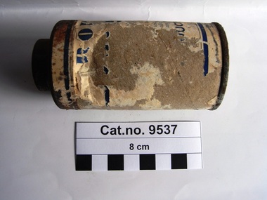 Coal Creek Community Park & Museum
Container, powder
Cardboard cylinder with metal base and metal shaker top. Remnants of paper label blue text on white on sides of cylinder. Still contains powder.Indistinct sections of text on side of cardboard. Powder in container.. '...cuts, wounds,........ to .... pint.......... twice this............... ....o large... ....s nor.... Registered Office ....inces Bridge.....'powder -
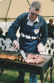 Port Melbourne Historical & Preservation Society
Photograph - Launch of History of a Street Precinct, 25 Sep
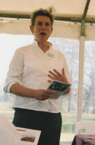
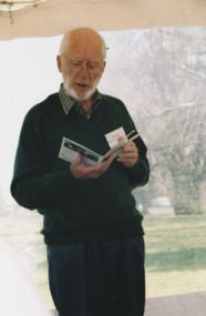
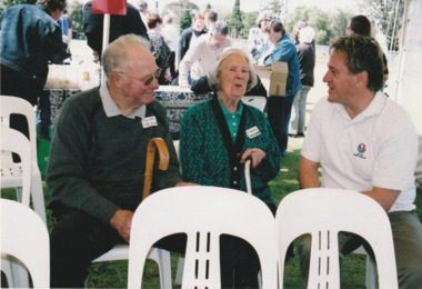
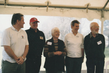
In 2005, members of the PMH&PS undertook a study of the residents of the houses in a Port Melbourne street precinct from the 1880s to 1960. The area is bounded by Evans Street, the E side of Bridge Street, S side of Williamstown Road, Farrell Street both the E & W sides plus the section of Ross Street between Farrell and Bridge and the part of Derham Street between Farrell and Bridge. The resulting map and an interactive CD won the Best Community Research, Registers & Records project at the 2007 Victorian Community History Awards. The project was launched on the railway reserve near the corner of Evans & Farrell streets. Jack BOLT is cooking with Ken TURNER in the background.Jack Bolt cooking sausages at the launch of the History of a Street Precinct25/9/05 Jack Bolt 11jack bolt, ken turner, history of a street precinct -
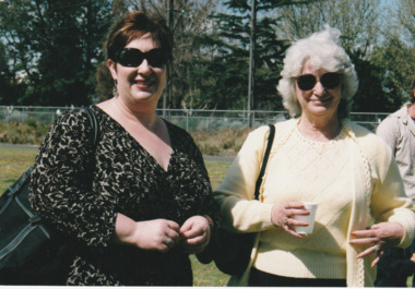 Port Melbourne Historical & Preservation Society
Photograph - Launch of History of a Street Precinct, 25 Sep
In 2005, members of the PMH&PS undertook a study of the residents of the houses in a Port Melbourne street precinct from the 1880s to 1960. The area is bounded by Evans Street, the E side of Bridge Street, S side of Williamstown Road, Farrell Street both the E & W sides plus the section of Ross Street between Farrell and Bridge and the part of Derham Street between Farrell and Bridge. The resulting map and an interactive CD won the Best Community Research, Registers & Records project at the 2007 Victorian Community History Awards. The project was launched on the railway reserve near the corner of Evans & Farrell streets. Liana ThOMPSON is with her mother , Fay BATES/ SHAW nee DEVINE.Liana Thompson & Fay Bates the launch of the History of a Street Precinct. 25/9/05 Liana Thompson, Fay Bates (previously Shaw nee Devine)liana thompson, fay bates, history of a street precinct -
 Port Melbourne Historical & Preservation Society
Photograph - Launch of History of a Street Precinct, 25 Sep
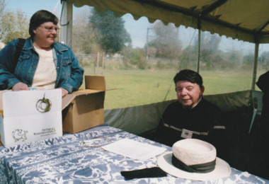
In 2005, members of the PMH&PS undertook a study of the residents of the houses in a Port Melbourne street precinct from the 1880s to 1960. The area is bounded by Evans Street, the E side of Bridge Street, S side of Williamstown Road, Farrell Street both the E & W sides plus the section of Ross Street between Farrell and Bridge and the part of Derham Street between Farrell and Bridge. The resulting map and an interactive CD won the Best Community Research, Registers & Records project at the 2007 Victorian Community History Awards. The project was launched on the railway reserve near the corner of Evans & Farrell streets. LL - R - unknown, Pat GRAINGER, Graham BRIDE.Pat GRAINGER, Graham BRIDE at the launch of the History of a Street Precinct project. 25/9/05 Not Known, Pat Grainger, Graham Bridepat grainger, graham bride, history of a street precinct -
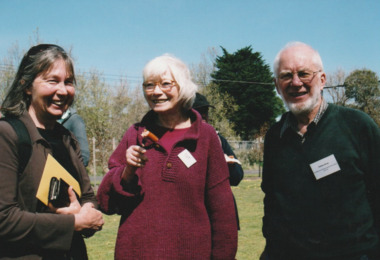
 Port Melbourne Historical & Preservation Society
Photograph - Launch of History of a Street Precinct, 25 Sep
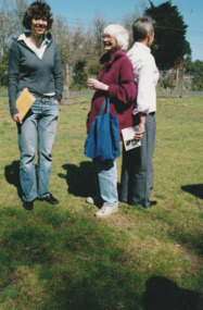
In 2005, members of the PMH&PS undertook a study of the residents of the houses in a Port Melbourne street precinct from the 1880s to 1960. The area is bounded by Evans Street, the E side of Bridge Street, S side of Williamstown Road, Farrell Street both the E & W sides plus the section of Ross Street between Farrell and Bridge and the part of Derham Street between Farrell and Bridge. The resulting map and an interactive CD won the Best Community Research, Registers & Records project at the 2007 Victorian Community History Awards. The project was launched on the railway reserve near the corner of Evans & Farrell streets. L- R - Natica SCHROEDER, Pat GRAINGER, Janet BOLITHO.Three members of the PMHPS the launch of the History of a Street Precinct25/9/05 Natica Schroeder, Pat Grainger, Janet Bolithohistory of a street precinct, pat grainger, natica schroeder, janet bolitho -
 Port Melbourne Historical & Preservation Society
Photograph - Launch of History of a Street Precinct, 25 Sep
In 2005, members of the PMH&PS undertook a study of the residents of the houses in a Port Melbourne street precinct from the 1880s to 1960. The area is bounded by Evans Street, the E side of Bridge Street, S side of Williamstown Road, Farrell Street both the E & W sides plus the section of Ross Street between Farrell and Bridge and the part of Derham Street between Farrell and Bridge. The resulting map and an interactive CD won the Best Community Research, Registers & Records project at the 2007 Victorian Community History Awards. The project was launched on the railway reserve near the corner of Evans & Farrell streets. L- R - Val POWER, Jim POWER.Two members of the PMHPS the launch of the History of a Street Precinct25/9/05 Val Power, Jim Powerhistory of a street precinct, val power, jim power -
 Port Melbourne Historical & Preservation Society
Photograph - Launch of History of a Street Precinct, 25 Sep
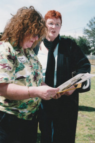
In 2005, members of the PMH&PS undertook a study of the residents of the houses in a Port Melbourne street precinct from the 1880s to 1960. The area is bounded by Evans Street, the E side of Bridge Street, S side of Williamstown Road, Farrell Street both the E & W sides plus the section of Ross Street between Farrell and Bridge and the part of Derham Street between Farrell and Bridge. The resulting map and an interactive CD won the Best Community Research, Registers & Records project at the 2007 Victorian Community History Awards. The project was launched on the railway reserve near the corner of Evans & Farrell streets. L- R - Robyn ?, Maralyn KOBELTMaralyn & Robin at the launch of the History of a Street Precinct25/9/05 Robyn ?, Maralyn Kobelthistory of a street precinct, maralyn kobelt -
 Port Melbourne Historical & Preservation Society
Photograph - Launch of History of a Street Precinct, 25 Sep
In 2005, members of the PMH&PS undertook a study of the residents of the houses in a Port Melbourne street precinct from the 1880s to 1960. The area is bounded by Evans Street, the E side of Bridge Street, S side of Williamstown Road, Farrell Street both the E & W sides plus the section of Ross Street between Farrell and Bridge and the part of Derham Street between Farrell and Bridge. The resulting map and an interactive CD won the Best Community Research, Registers & Records project at the 2007 Victorian Community History Awards. The project was launched on the railway reserve near the corner of Evans & Farrell streets. Darren Ray, Mayor of City of Port Phillip.City of Port Phillip mayor, Cr Darren Ray at the launch of the History of a Street Precinct25/9/05 Darren Ray Mayor CoPPhistory of a street precinct, darren ray -
 Port Melbourne Historical & Preservation Society
Photograph - Launch of History of a Street Precinct, 25 Sep
In 2005, members of the PMH&PS undertook a study of the residents of the houses in a Port Melbourne street precinct from the 1880s to 1960. The area is bounded by Evans Street, the E side of Bridge Street, S side of Williamstown Road, Farrell Street both the E & W sides plus the section of Ross Street between Farrell and Bridge and the part of Derham Street between Farrell and Bridge. The resulting map and an interactive CD won the Best Community Research, Registers & Records project at the 2007 Victorian Community History Awards. The project was launched on the railway reserve near the corner of Evans & Farrell streets. Janet BOLITHO, former mayor of City of Port Phillip.Former City of Port Phillip mayor, Janet Bolitho, at the launch of the History of a Street Precinct25/9/05 Janet Bolithohistory of a street precinct, janet bolitho -
 Port Melbourne Historical & Preservation Society
Photograph - Launch of History of a Street Precinct, 25 Sep
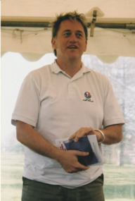
In 2005, members of the PMH&PS undertook a study of the residents of the houses in a Port Melbourne street precinct from the 1880s to 1960. The area is bounded by Evans Street, the E side of Bridge Street, S side of Williamstown Road, Farrell Street both the E & W sides plus the section of Ross Street between Farrell and Bridge and the part of Derham Street between Farrell and Bridge. The resulting map and an interactive CD won the Best Community Research, Registers & Records project at the 2007 Victorian Community History Awards. The project was launched on the railway reserve near the corner of Evans & Farrell streets. Co-author Graham BRIDE.Co-author, Graham Bride, at the launch of the History of a Street Precinct25/9/05 Graham Bridehistory of a street precinct, graham bride -
 Port Melbourne Historical & Preservation Society
Photograph - Launch of History of a Street Precinct, 25 Sep
In 2005, members of the PMH&PS undertook a study of the residents of the houses in a Port Melbourne street precinct from the 1880s to 1960. The area is bounded by Evans Street, the E side of Bridge Street, S side of Williamstown Road, Farrell Street both the E & W sides plus the section of Ross Street between Farrell and Bridge and the part of Derham Street between Farrell and Bridge. The resulting map and an interactive CD won the Best Community Research, Registers & Records project at the 2007 Victorian Community History Awards. The project was launched on the railway reserve near the corner of Evans & Farrell streets. L - R - Unknown, Norah HOWARD, Mayor Darren RAY.CoPP mayor and PMHPS members at the launch of the History of a Street Precinct25/9/05 Not known, Norah Howard, Darren Ray, Mayorhistory of a street precinct, darren ray, norma howard -
 Port Melbourne Historical & Preservation Society
Photograph - Launch of History of a Street Precinct, 25 Sep
In 2005, members of the PMH&PS undertook a study of the residents of the houses in a Port Melbourne street precinct from the 1880s to 1960. The area is bounded by Evans Street, the E side of Bridge Street, S side of Williamstown Road, Farrell Street both the E & W sides plus the section of Ross Street between Farrell and Bridge and the part of Derham Street between Farrell and Bridge. The resulting map and an interactive CD won the Best Community Research, Registers & Records project at the 2007 Victorian Community History Awards. The project was launched on the railway reserve near the corner of Evans & Farrell streets. l - R - Mayor Darren RAY, David THOMPSON, Margaret BRIDE, Janet BOLITHO, Graham BRIDE.CoPP mayor and PMHPS members involved in the production at the launch of the History of a Street Precinct25/9/05 Mayor, David Thompson, Margaret Bride, Janet Bolitho, Graham Bridehistory of a street precinct, darren ray, graham bride, margaret bride, janet bolitho, david thompson -
 Port Melbourne Historical & Preservation Society
Photograph - Launch of History of a Street Precinct, 25 Sep
In 2005, members of the PMH&PS undertook a study of the residents of the houses in a Port Melbourne street precinct from the 1880s to 1960. The area is bounded by Evans Street, the E side of Bridge Street, S side of Williamstown Road, Farrell Street both the E & W sides plus the section of Ross Street between Farrell and Bridge and the part of Derham Street between Farrell and Bridge. The resulting map and an interactive CD won the Best Community Research, Registers & Records project at the 2007 Victorian Community History Awards. The project was launched on the railway reserve near the corner of Evans & Farrell streets. L - R - Unknown, Janet BOLITHO, Glen STUART.CoPP mayor and PMHPS members at the launch of the History of a Street Precinct25/9/05 Not known, Janet Bolitho, Glen Stuarthistory of a street precinct, janet bolitho, glen stuart -
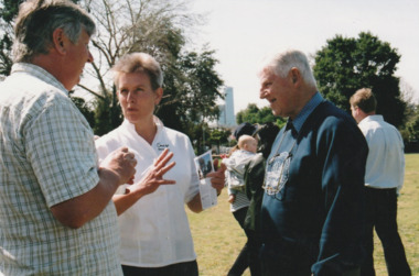
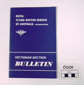 Royal Flying Doctor Service of Australia, Victorian Section
Newsletter, The Ruskin Press, Victorian Section Bulletin Vol 1, No 1, 03/1970
... Royal Flying Doctor Service of Australia, Victorian Section ...1st Quarterly Bulletin produced of Kimberley Region stories and events in Victoria of the time. Bulletins produced until Distribution to This is the 1st Bulletin produced by Victorian Section relating to Corporate and historical significanceSmall 12 page A5 printed book. Journal articles from President, Annual meeting, Obitiuary Malcolm Moore,Guest Speaker W. A. Minister, Admiralty Gulf - Mitchell Plateau, Wyndham-Kununurra, RFDS Operations in the Kimberley,Man Lost on Drysdale River, Profile A.S. McLaughlan, Country Women's Association/ West Kimberley Air Branch, Donations 01/10/69-31/01/70 bulletin, newsletter, rfds victorian section, kimberley region, donations -
Port Melbourne Historical & Preservation Society
Plan - Proposed footbridge over the Lagoon, Bridge Street, Port Melbourne, 1863
Plan of proposed footbridge over the Lagoon in line of Bridge StreetIn ink on reverse, two small drawings: elevation land view over a distance of 25.00 chains (colour tinted), and Plan view, section of an unidentified street:In pencil on reverse, notation '107 Albert Street'sandridge lagoon, robert h morgan -
Port Melbourne Historical & Preservation Society
Plan - Annotated and handcoloured by Peter Libbis to indicate his research into Libbis family residences and hotels on copy of a section of an MMBW map, Melbourne and Metropolitan Board of Works, c. 1980s
Peter LIBBIS obtained these copies from the MMBW when he researched his family history in the 1980s. He has annotated them, colour in hotels etc. Donated to Society in 1997.One of a group of 19 photocopies of various 20th century MMBW plans, annotated/coloured in to indicate residences of Libbis family and local hotels, by Peter LIBBIS in family and hotel research - Ross to Clark, Graham to Bridge, date unknownbusiness and traders - hotels, built environment - domestic, transport - railways, melbourne and metropolitan board of works, libbis family, caroline libbis, thomas libbis -
Port Melbourne Historical & Preservation Society
Plan - Annotated and handcoloured by Peter Libbis to indicate his research into Libbis family residences and hotels on copy of a section of an MMBW map, Melbourne and Metropolitan Board of Works, c. 1980s
Peter LIBBIS obtained these copies from the MMBW when he researched his family history in the 1980s. He has annotated them, colour in hotels etc. Donated to Society in 1997.One of a group of 19 photocopies of various 20th century MMBW plans, annotated/coloured in to indicate residences of Libbis family and local hotels, by Peter LIBBIS in family and hotel research - Nott to Dow, Graham to Bridge, post 1938business and traders - hotels, built environment - domestic, transport - railways, melbourne and metropolitan board of works, libbis family -
Port Melbourne Historical & Preservation Society
Plan - Annotated and handcoloured by Peter Libbis to indicate his research into Libbis family residences and hotels on copy of a section of an MMBW map, Melbourne and Metropolitan Board of Works, c. 1980s
Peter LIBBIS obtained these copies from the MMBW when he researched his family history in the 1980s. He has annotated them, colour in hotels etc. Donated to Society in 1997.One of a group of 19 photocopies of various 20th century MMBW plans, annotated/coloured in to indicate residences of Libbis family and local hotels, by Peter LIBBIS in family and hotel research - Pickles Street, Bridge to Liardet - date unknownbusiness and traders - hotels, built environment - domestic, transport - railways, melbourne and metropolitan board of works, libbis family