Showing 391 items
matching bridges -- yarra river
-
 Eltham District Historical Society Inc
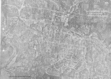
Work on paper (Sub-Item) - Aerial Photograph, Diamond Creek from Yarra River to Wattletree Road, Eltham
... the central place of Eltham township marked inluding Yarra River, Main... River, Main Road, Bridge Street and Ryans Road, Eltham North ...Black and white aerial photograph witrh key features around the central place of Eltham township marked inluding Yarra River, Main Road, Bridge Street and Ryans Road, Eltham North land development, real estate, aerial view, eltham, eltham north -
 Eltham District Historical Society Inc
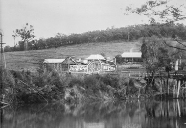
Photograph, Henley Bridge, c.1928
Situated on the Yarra River, 5.5 kms south of Christmas Hills on private property. This timber trestle bridge is said to have been built some time after 1907 by Melbourne master-builder, David Mitchell (the father of Dame Nellie Melba), to connect his two "Henley Farm" properties with Lilydale. In earlier days, when the McPhersons owned the property, their children used a punt to cross the river to attend Yering Primary School. This private bridge is best viewed from the end of Wendy Way. - Source: Christmas Hills Past and Present, Yarra Glen & District Historical Society, 2004.This photo forms part of a collection of photographs gathered by the Shire of Eltham for their centenary project book,"Pioneers and Painters: 100 years of the Shire of Eltham" by Alan Marshall (1971). The collection of over 500 images is held in partnership between Eltham District Historical Society and Yarra Plenty Regional Library (Eltham Library) and is now formally known as the 'The Shire of Eltham Pioneers Photograph Collection.' It is significant in being the first community sourced collection representing the places and people of the Shire's first one hundred years.9 x 12.5 cm printshire of eltham pioneers photograph collection, warrandyte, henley bridge -
 Eltham District Historical Society Inc
Book, Diamond Creek Basin Study. Part 1, A Compendium of Factors Relevant to Stormwater Flows, 1980
Basin Studies are studies to evaluate water supply and demand and help ensure reliable water supplies by identifying strategies to address imbalances in water supply and demand.Spiral Bound. 157 leaves in various foliations (some folded) : illustrated. (some colour.), maps (some colour.)aerial photographs, allendale road, arthurs creek mine, arthurs creek road bridge, arthurs creek, bald spur look-out, bank protection, bolton steet, bridge street bridge, bridge street, bridges, challenger street, chute street, construction, coolaroo drive, culvert, deep creek, diamond creek basin, diamond creek region, diamond creek, diamond street bridge, drainage works, eltham lower park, eltham town park, eltham trestle bridge, eltham west drains, eltham, erosion, flood management, floods, footbridge, glen katherine estate, gold mining, gum glade, hurstbridge, kangaroo ground, kinglake escarpment, kinglake national park, latiners hat factory, main road bridge, main road, masons falls, melbourne metropolitan board of works, monash bridge, mount sugarloaf, nillumbik park, orchards, railway culvert, railway line, ramptons road, real estate advertisement, research creek, st helena east drain, st helena road, st helena, storm sewers, stormwater, sugarloaf-preston transfer main crossing, susan street, union mine, village pond, water flow, watkins street, wattletree road, weidlich road, wingrove park, yarra river, zig zag road, water supply, basin study -
 Eltham District Historical Society Inc
Photograph, George Coop, A day in Melbourne, Morell Bridge, South Yarra, November 1962, 1962
... Melbourne, Morell Bridge, South Yarra, Yarra River... melbourne Melbourne, Morell Bridge, South Yarra, Yarra River Digital ...Digital TIFF file Scan of 35mm Ilford FP3 black and white transparencymelbourne, morell bridge, south yarra, yarra river -
 Eltham District Historical Society Inc
Photograph, George Coop, A day in Melbourne, Morell Bridge, South Yarra, November 1962, 1962
... melbourne, morell bridge, south yarra, yarra river... melbourne melbourne, morell bridge, south yarra, yarra river Digital ...Digital TIFF file Scan of 35mm Ilford FP3 black and white transparencymelbourne, morell bridge, south yarra, yarra river -
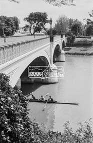 Eltham District Historical Society Inc
Photograph, George Coop, A day in Melbourne, Morell Bridge, South Yarra, November 1962, 1962
... melbourne, morell bridge, rowing, south yarra, yarra river... melbourne melbourne, morell bridge, rowing, south yarra, yarra river ...Digital TIFF file Scan of 35mm Ilford FP3 black and white transparencymelbourne, morell bridge, rowing, south yarra, yarra river -
 Eltham District Historical Society Inc
Photograph, George Coop, A day in Melbourne, Morell Bridge, South Yarra, November 1962, 1962
... melbourne, morell bridge, south yarra, yarra river... melbourne melbourne, morell bridge, south yarra, yarra river Digital ...Digital TIFF file Scan of 35mm Ilford FP3 black and white transparencymelbourne, morell bridge, south yarra, yarra river -
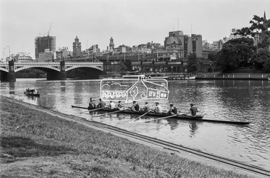 Eltham District Historical Society Inc
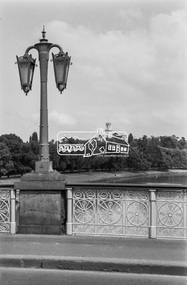
Photograph, George Coop, A day in Melbourne, November 1962, 1962
... , Swanston Street, Yarra River..., Swanston Street, Yarra River Digital TIFF file Scan of 35mm Ilford ...Princes Bridge, Flinders Street Station in background.Digital TIFF file Scan of 35mm Ilford FP3 black and white transparencyflinders street station, melbourne, princes bridge, rowing, swanston street, yarra river -
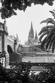 Eltham District Historical Society Inc
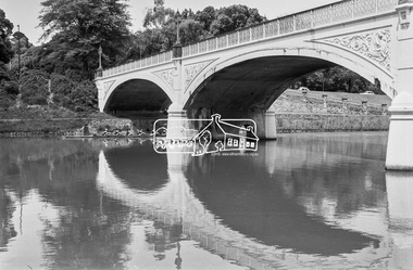
Photograph, George Coop, A day in Melbourne, Princes Bridge, November 1962, 1962
... Melbourne, Princes Bridge, Yarra River... melbourne Melbourne, Princes Bridge, Yarra River Digital TIFF file ...Digital TIFF file Scan of 35mm Ilford FP3 black and white transparencymelbourne, princes bridge, yarra river -
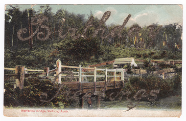 Marysville & District Historical Society
Postcard (item) - Colour tinted postcard, Nicholas John Caire, Marysville Bridge, Victoria, Austr, 1878-1904
One of a series of postcards of photographs taken by socialite photographer Nicholas John Caire.One of a series of postcards of photographs taken by socialite photographer Nicholas John Caire. N.J. Caire had a great love for the area in and surrounding Marysville and in the late 1800's took many photographs of Marysville and its surrounds. N.J. Caire was born in 1837 in Guernsey. He arrived in Adelaide about 1860 along with his parents who encouraged his early interest in photography. He opened a studio in Adelaide in 1867 after traveling extensively throughout the Gippsland taking photographs. After marrying in 1870 he moved to Talbot in Victoria until 1876 when he opened a studio in the Royal Arcade in Melbourne. After 1885 N.J. Caire gave up his city work and made his home in South Yarra and devoted the rest of his life to outdoor photography, specializing in the bush, the gullies and the mountains of south-eastern Victoria.Birthday/ Greetings POST CARD This Space may be Used/ for Correspondence The Address Only to be/ Written Here. 88421 Dear Ivy/ Wishing you/ many happy/ returns of/ the day/ from Reggie Miss Ivy Bastian/ Helston/ Fenwick Street/ Nth Carlton c1918 2nd Bridge The postage stamp has been removed. Helen Boach?marysville, victoria, nicholas john caire, bridge scene, 88421, postcard, souvenir -
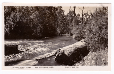 Marysville & District Historical Society
Postcard (item) - Black and white postcard, Rose Stereograph Company, The Stevenson River, Marysville, Vic, 1913-1967
A postcard in a series produced by the Rose Stereograph Company in Victoria, Australia as a souvenir of Marysville.A black and white photograph of the Stevenson (Steavenson) River that runs through Marysville in Victoria. The Steavenson River is named after the Victorian Assistant Commissioner of Roads and Bridges, John Steavenson who arrived here in the early 1860s.POST CARD The "Rose" Series/ De Luxe A Real Photograph/ Produced in Australia Published by the Rose Stereograph Co.,/ Armadale, Victoriastevenson river, steavenson river, marysville, victoria, p. 4945, rose series postcard, postcard, souvenir, john steavenson -
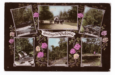 Marysville & District Historical Society
Postcard (item) - Colour postcard, Stanley Mullen Pty Ltd, Greetings from Victoria, Early 1900's
A colour postcard with six colour photographs of attractions in an around Marysville in Victoria. This postcard was produced by Stanley Mullen Pty Ltd. of Melbourne as a souvenir of Marysville.A colour postcard with four colour photographs of attractions in an around Marysville in Victoria.Greetings from Victoria The Yea River, Tallangi/ Resting, Fernshaw/ The Rapids, Watts River/ Waterfalls, Sylvia Creek/ Tram Track, Warburton/ Bush Bridge POST CARD Stanley Mullen Pty Ltd., Melbourne Printed in Germany Date Stamp-CARLTON NORTH-VICTORIA/ -2FE10 French stamp Ma soer voudrait favie/ les memes exchanges/ que moi. Son/ addresse est./ Miss. B. Coleman/ 95 Richardson St/ N. Carlton/ Avee mes meilleurs/ souhaits/ Votre tres devouee/ R. Coleman STAMP/ ON/ BACK Monsieur A. Rochet/ 22 Rue Longue,/ Lyon/ Rhone/ Francemarysville, victoria, yea river, tallangi, fernshaw, watts river, waterfall, sylvia creek, warburton, bridge, stanley mullen, postcard, souvenir, tram track -
 Marysville & District Historical Society
Flyer (item) - Brochure, Artworkz Tourism, Marysville-Steavenson Falls, 2018
A brochure including photographs and a tourist map of Marysville and some of the area's attractions focusing on Steavenson Falls. A brochure including photographs and a tourist map of Marysville and some of the area's attractions focusing on Steavenson Falls. The Steavenson Falls is named after the Victorian Assistant Commissioner of Roads and Bridges, John Steavenson who arrived in Victoria in the early 1860s.Shadowed by over 30 Mountains and/ on the banks of the beautiful Goulburn River/ and Lake Eildon. This is our playground.marysville, steavenson falls, victoria, waterfalls, john steavenson -
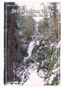 Marysville & District Historical Society
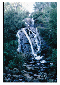
Postcard (item) - Colour postcard, Graphic in Print, Steavenson Falls-Marysville, Vic, 2004
A colour photograph of Steavenson Falls in Marysville in Victoria.A colour photograph of Steavenson Falls in Marysville in Victoria during winter. The information on the reverse of the postcard that states that the Steavenson River was named after John Steavenson who surveyed Marysville in 1863 is incorrect. The Steavenson Falls and River are named after the Victorian Assistant Commissioner of Roads and Bridges, John Steavenson who arrived in Victoria in the early 1860s. This postcard was produced by Graphic in Print as a souvenir of Marysville.Steavenson Falls after a low snowfall. The spectacular Steavenson Falls is just 5 minutes drive/ from Marysville, Victoria. They are claimed to be the/ tallest falls in the state, dropping 82 metres in three/ stages. The falls are fed by the Steavenson River, named/ after John Steavenson who surveyed Marysville in 1863. Graphic in Print/ Postcards Place/ Stamp/ Here Graphic in Print/ Waterfall Collection/ Classic 1/ c2004steavenson falls, marysville, victoria, waterfalls, winter, snow, graphic in print, postcard, souvenir, john steavenson -
 Marysville & District Historical Society
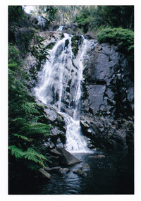
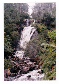
Photograph (item) - Colour photograph, Pre 2009
A colour photograph of Steavenson Falls in Marysville in Victoria.A colour photograph of Steavenson Falls in Marysville in Victoria. The Steavenson Falls is named after the Victorian Assistant Commissioner of Roads and Bridges, John Steavenson who arrived in Victoria in the early 1860s.steavenson falls, waterfalls, marysville, victoria, john steavenson -
 Marysville & District Historical Society
Photograph (item) - Colour photograph, 2002
A colour photograph of Steavenson Falls in Marysville in Victoria.A colour photograph of Steavenson Falls in Marysville in Victoria. The Steavenson Falls is named after the Victorian Assistant Commissioner of Roads and Bridges, John Steavenson who arrived in Victoria in the early 1860s.Marysville 2002steavenson falls, waterfalls, marysville, victoria, john steavenson -
 Marysville & District Historical Society
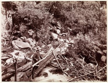
Photograph (item) - Black and white photograph, Unknown
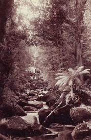
An early black and white photograph of a man attempting to repair the tree bridge which once traversed the Steavenson River at the base of Steavenson Falls.An early black and white photograph of a man attempting to repair the tree bridge which once traversed the Steavenson River at the base of Steavenson Falls. The Steavenson Falls is named after the Victorian Assistant Commissioner of Roads and Bridges, John Steavenson who arrived in Victoria in the early 1860s.steavenson falls, steavenson river, marysville, victoria, waterfalls, john steavenson -
 Marysville & District Historical Society
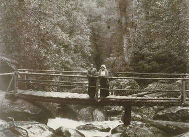
Photograph (item) - Black and white photograph, Unknown
An early black and white photograph which shows a man and a woman standing on the bridge that crosses the Steavenson River at the base of the Steavenson Falls in Marysville in Victoria.An early black and white photograph which shows a man and a woman standing on the bridge that crosses the Steavenson River at the base of the Steavenson Falls in Marysville in Victoria. The Steavenson Falls are named after the Victorian Assistant Commissioner of Roads and Bridges, John Steavenson who arrived in Victoria in the early 1860s.steavenson river, steavenson falls, marysville, victoria, waterfalls, john steavenson -
 Marysville & District Historical Society
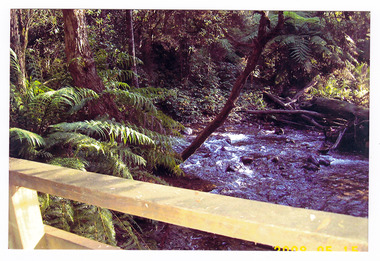
Photograph (item) - Colour photograph, Pre 2009
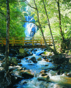
A colour photograph of the wooden bridge over the Steavenson River at the base of the Steavenson Falls in Marysville in Victoria.A colour photograph of the wooden bridge over the Steavenson River at the base of the Steavenson Falls in Marysville in Victoria. This bridge was destroyed in the 2009 Black Saturday bushfires. The Steavenson Falls are named after the Victorian Assistant Commissioner of Roads and Bridges, John Steavenson who arrived in Victoria in the early 1860s.steavenson river, steavenson falls, marysville, victoria, waterfalls, john steavenson, 2009 black saturday bushfires -
 Marysville & District Historical Society
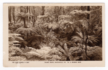
Postcard (item) - Black and white postcard, Rose Stereograph Company, Talbot Drive, Marysville, Vic. No. 2, Michael Dene, 1913-1967
A postcard in a series produced by the Rose Stereograph Company in Victoria, Australia as a souvenir of Marysville.A black and white photograph showing trees and tree ferns, taken along the Michaeldene Trail near Lady Talbot Drive in Marysville in Victoria. The Michaeldene Trail is a level two loop that leads to the Taggerty River Lookout and may be undertaken as either as a Short (2.7 km) Loop, or a Long (4.3 km) Loop - 30 minutes to one hour and a half. The attractive bushland linking the Steavenson and Taggerty Rivers allows walkers and cyclists to step back in time to Marysville’s historic logging past. Sections of this mostly flat circuit follow old tramline alignments, which in places reveal the original timber sleepers on which the big logs were transported to the nearby sawmill.The Taggerty River Lookout offers views over the Taggerty River. The Trestle Bridge was built to span a small gully and provide access to the timber on Red Hill. Lady Talbot Drive is a 24 kilometer scenic rainforest car journey which passes a number of walks and waterfalls in the Yarra Ranges National Park. Lady Talbot Drive is named after Lady Sarah Elizabeth, the wife of Sir Reginald Talbot, who was the Governor of Victoria from 25th April, 1904 to 6th July 1908. This postcard was produced by the Rose Stereograph Company as a souvenir of Marysville.REAL PHOTO POST CARD THE "ROSE"SERIES DE LUXE PRODUCED IN AUSTRALIA Published by "The Rose Stereographs" Armadale, Victoria.marysville, victoria, michael dene, michael dene track, p. 2307, walking track, rose series postcard, postcard, souvenir, lady talbot drive, sarah elizabeth talbot, sir reginald talbot -
 Marysville & District Historical Society
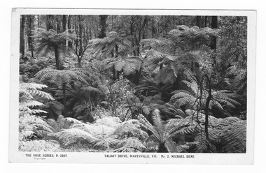
Postcard (item) - Black and white postcard, Rose Stereograph Company, Talbot Drive, Marysville, Vic. No. 2, Michael Dene, 1913-1967
A postcard in a series produced by the Rose Stereograph Company in Victoria, Australia as a souvenir of Marysville.A black and white photograph showing trees and tree ferns, taken along the Michaeldene Trail near Lady Talbot Drive in Marysville in Victoria. The Michaeldene Trail is a level two loop that leads to the Taggerty River Lookout and may be undertaken as either as a Short (2.7 km) Loop, or a Long (4.3 km) Loop - 30 minutes to one hour and a half. The attractive bushland linking the Steavenson and Taggerty Rivers allows walkers and cyclists to step back in time to Marysville’s historic logging past. Sections of this mostly flat circuit follow old tramline alignments, which in places reveal the original timber sleepers on which the big logs were transported to the nearby sawmill.The Taggerty River Lookout offers views over the Taggerty River. The Trestle Bridge was built to span a small gully and provide access to the timber on Red Hill. Lady Talbot Drive is a 24 kilometer scenic rainforest car journey which passes a number of walks and waterfalls in the Yarra Ranges National Park. Lady Talbot Drive is named after Lady Sarah Elizabeth, the wife of Sir Reginald Talbot, who was the Governor of Victoria from 25th April, 1904 to 6th July 1908.REAL PHOTO POST CARD THE "ROSE"SERIES DE LUXE PRODUCED IN AUSTRALIA Published by the Rose Stereographs Armadale, Victoria. Tomorrow is your Official day/ I believe. So Very Very many happy/ returns, & best of luck & good/ wishes from/ your May I rec'd this on/ 1st. (illegible)/ thought it a good snap of our ferns.marysville, victoria, michael dene, michael dene track, p. 2307, walking track, rose series postcard, postcard, souvenir, lady talbot drive, sarah elizabeth talbot, sir reginald talbot -
 Marysville & District Historical Society
Photograph (item) - Black and white photograph, Unknown
A black and white photograph of two ladies standing on a timber bridge crossing the Taggerty River.A black and white photograph of two ladies standing on a timber bridge crossing the Taggerty River.taggerty river, timber bridge -
 Marysville & District Historical Society
Photograph (item) - Colour photograph, 15-05-2008
A colour photograph of a wooden bridge crossing over the Taggerty River.A colour photograph of a wooden bridge crossing over the Taggerty River.2008 05 15taggerty river, wooden bridge -
 Marysville & District Historical Society
Photograph (item) - Colour photograph, 15-05-2008
A colour photograph of the wooden bridge crossing the Taggerty River. A colour photograph of the wooden bridge crossing the Taggerty River. 2008 05 15taggerty river, wooden bridge -
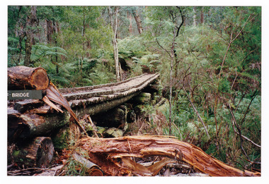
 Marysville & District Historical Society
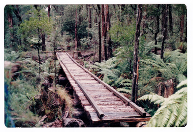
Photograph (item) - Colour photograph, Doug Orford, Unknown
A colour photograph of the timber tramway bridge along the Michaeldene Walking Track near Marysville in Victoria.A colour photograph of the timber tramway bridge along the Michaeldene Walking Track near Marysville in Victoria. The Michaeldene Trail to Taggerty River Lookout is a 4.3 kilometer lightly trafficked loop trail located near Marysville, Victoria. The track is one of several walking tracks located in and around Marysville in Victoria.Doug ORFORDtimber tramway, michaeldene walking track, marysville, victoria, walking track -
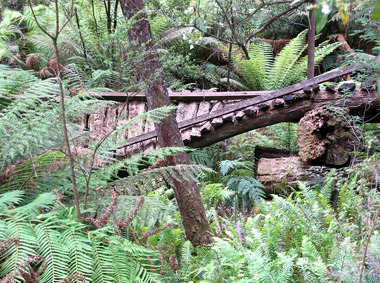
 Marysville & District Historical Society
Photograph (item) - Colour photograph, 1996
A colour photograph of the timber tramway bridge along the Michaeldene Walking Track near Marysville in Victoria.A colour photograph of the timber tramway bridge along the Michaeldene Walking Track near Marysville in Victoria. The Michaeldene Trail to Taggerty River Lookout is a 4.3 kilometer lightly trafficked loop trail located near Marysville, Victoria. The track is one of several walking tracks located in and around Marysville in Victoria.1996timber tramway, michaeldene walking track, marysville, victoria, walking track -
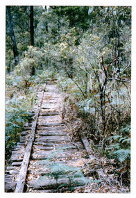 Marysville & District Historical Society
Photograph (item) - Colour photograph, 01-1964
A colour photograph of the timber tramway bridge along the Michaeldene Walking Track near Marysville in Victoria.A colour photograph of the timber tramway bridge along the Michaeldene Walking Track near Marysville in Victoria. The Michaeldene Trail to Taggerty River Lookout is a 4.3 kilometer lightly trafficked loop trail located near Marysville, Victoria. The track is one of several walking tracks located in and around Marysville in Victoria.MARYSVILLE JANUARY 1964timber tramway, michaeldene walking track, marysville, victoria, walking track -
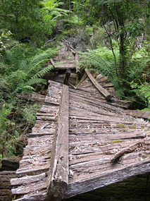 Marysville & District Historical Society
Photograph (item) - Colour photograph, 31-12-2008
A digital copy of a colour photograph of the timber tramway bridge along the Michaeldene Walking Track near Marysville in Victoria.A digital copy of a colour photograph of the timber tramway bridge along the Michaeldene Walking Track near Marysville in Victoria. The Michaeldene Trail to Taggerty River Lookout is a 4.3 kilometer lightly trafficked loop trail located near Marysville, Victoria. The track is one of several walking tracks located in and around Marysville in Victoria.timber tramway, michaeldene walking track, marysville, victoria, walking track -
 Marysville & District Historical Society
Photograph (item) - Colour photograph, 31-12-2008
A digital copy of a colour photograph of the timber tramway bridge along the Michaeldene Walking Track near Marysville in Victoria.A digital copy of a colour photograph of the timber tramway bridge along the Michaeldene Walking Track near Marysville in Victoria. The Michaeldene Trail to Taggerty River Lookout is a 4.3 kilometer lightly trafficked loop trail located near Marysville, Victoria. The track is one of several walking tracks located in and around Marysville in Victoria.timber tramway, michaeldene walking track, marysville, victoria, walking track