Showing 2036 items
matching building plan
-
 Bendigo Historical Society Inc.
Book - HISTORIC BUILDINGS COUNCIL - VICTORIA, 1990s (?)
... , building registers, heritage planning and education and sketches...COTTAGE Miners Historic Buildings Council of Victoria 12 ...12 page booklet about the Historic Buildings Council of Victoria. Includes background and aims of the council, membership, building registers, heritage planning and education and sketches of various buildings. Blank inserts. 2 copies of pink form 'Application to add building to Register' and 2 copies of white form 'Application for Financial Assistance'Historic Buildings Council of Victoriacottage, miners -
 Greensborough Historical Society
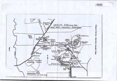
Map, Mont Park buildings still existing, 1946_
... Locality Plan indicates buildings still existing within... Plenty Lower Plenty melbourne Locality Plan indicates buildings ...Locality Plan indicates buildings still existing within the Mont Park - Larundel mental health complex; Table lists 16 buildings by year built, initial purpose, subsequent uses and current address2 pages,one map, one table larundel, mont park -
 Kiewa Valley Historical Society
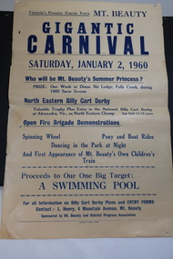
Poster - Mt Beauty Gigantic Carnival, 1960
... in the local East and West Kiewa Rivers. The community began planning... and West Kiewa Rivers. The community began planning the building ...The residents of Mt Beauty and the Kiewa Valley swam in the local East and West Kiewa Rivers. The community began planning the building of a swimming pool at Mt Beauty in the early 1960s and held events to raise money for it. The building of a swimming pool in Mt Beauty is part of the construction town's development and demonstrates the support of the community, especially the Mt Beauty and District Progress Association, and the SECV.Yellowed paper with black print dated Saturday, January 2, 1960 advertising the events for the day at Mt Beauty. Proceeds to the Swimming Pool.mt beauty swimming pool, carnival, mt beauty and district progress association -
 University of Melbourne, Burnley Campus Archives
Plan, C.E. Richardson, Burnley Gardens, 1965
... 5 printed plans with buildings marked in black. Drawn... school of horticulture 5 printed plans with buildings marked ...5 printed plans with buildings marked in black. Drawn by C.E. Richardson, P.R.L. 6th August, 1965, amended 1st December, 1965. Marked: Project No 1 (Engineering Building) and Project No 2 (Plant Sciences Building.) burnley gardens, buildings, burnley school of horticulture -
 Bendigo Historical Society Inc.
Document - MERLE HALL COLLECTION: DOCUMENTS RELATING TO FEASIBILITY OF BENDIGO ARTS CENTRE 1970 TO1977
... Centre) - attached are a site plan, building plans(convention... Centre) - attached are a site plan, building plans(convention ...Various documents relating to feasibility of Bendigo Arts Centre 1970-1977 - Correspondence; various notes (some handwritten); large plan of Crestknit factory layout; information re Public Meeting 12/10/1976; Address to Bendigo City Council by Dr Westbrook 15/9/1975; Bendigo Arts Activity Centre - Draft Brief; Bendigo Arts Council Minutes (50th meeting held 6y/4/1976); Performing Arts Centre Study - Sub-Committee Meeting 6/9/1976; Public Notice in Bendigo Advertiser for a Proposed Community Arts Activity Centre (16/10/197?); Statement fro Bendigo Arts Council re a Performing Arts Centre for Bendigo - what the Council knows & what the Council recommends; letter from The Bendigo Trust 29th March 1976 with details of the proposed Convention Centre to be part of the Dai Gum San project on Danger Hill (the Trust believing that a Cultural Centre should be incorporated into the proposed Convention Centre) - attached are a site plan, building plans(convention hall, proposed ground floor theatre and two architectural elevations of the proposed convention centre, -
 St Kilda Historical Society
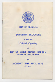
Souvenir - Brochure, Souvenir Brochure to mark the Official Opening of the St. Kilda Public Library, 1973
... and fitout of the building; a floor plan; and members of the Council... and fitout of the building; a floor plan; and members of the Council ...Souvenir brochure to mark the official opening of St Kilda Public Library on 14 May 1973 by Sir Rohan Delacombe, State Governor. Includes information about the the establishment of the library, its holdings and services; details about the construction and fitout of the building; a floor plan; and members of the Council, Library Sub-Committee and library staff.Eight-page brochure with a white card cover, discoloured with age, printed in blue.st kilda public library -
Federation University Historical Collection
Drawing - Rubbing, Rubbing on a plaque relating to the Sky High Restaurant
... March 1971 This building was planned and constructed... for Tourism on the 25th March 1971 This building was planned ...This is thought to be the work of Keith Rash of Ballarat.A number of rubbings from plaques on buildings. .1) Sky High Restaurant .2) Pioneers Tablet (Probably relating to the Pioneers Plot at the Ballaarat Old Cemetery. .3) and .4) Plaque relating to the Pioneers tablet.1) This Skyhigh restaurant was officially opened by The Hon. Vance Dickie M.L.C. Minister for Tourism on the 25th March 1971 This building was planned and constructed for The Ministry of Tourism J. Dale Fisher F.R.A.I.A. Architect W.J. Cody & Quinn Pty Ltd Builders .2) (logo) This tablet was erected by the citizens of Ballarat in honour of the pioneers of this city and district. .3) This MEMORIAL TABLET was unveiled on the 3rd May 1961 by F.W. WRAY, Esq in the company of S.C. HENDERSON, Esq. The only remaining members of the Original Pioneers Memorial Committee.architecture, j. dale, w, j, cody & quinn, skyhigh restaurant, frottage, rubbing, ballarat pioneers, keith rash -
 Robin Boyd Foundation
Drawing - Architectural, Robin Boyd, 290 Walsh Street, South Yarra, 14-Jan-58
... . The finished building differs from these plans in some interesting ways.... The finished building differs from these plans in some interesting ways ...This reproduction of the 1958 architectural drawings for 290 Walsh Street gives insight into Boyd's design. The finished building differs from these plans in some interesting ways - for example, the upstairs balcony cantilevers twice as far as originally drawn.Working Drawing, Colour copy, Paper type A1 -
Glenelg Shire Council Cultural Collection
Certificate - Certificate - Historic Buildings, Portland Town Hall, 1974
... for planning & Historic Buildings Council Chairperson. Red seal... for planning & Historic Buildings Council Chairperson. Red seal ...From the Victorian Heritage Register: The foundation stone of the original Portland Town Hall was laid by William Learmonth on 21st September, 1863 following a competition and subsequent public controversy over the permitted entry of architect John Barrow. The conservative classical design of municipal surveyor Alexander Ross was preferred and this axially planned design with central council chamber and side offices fronted by a fine axed pedimented gable entablature of basalt and Tuscan Doric pilasters was completed by 24th may 1864. The old Town Hall is one of a distinguished group of public buildings in Portland and an interesting example of conservative classical architecture of the first years of settlement in western Victoria. The basalt structure was partially erected of stone from the Portland stockade and has significant historical associations with local Government administration in the district. The Town Hall is the most impressive work of Alexander Ross, a surveyor architect whose career remains largely undocumented. The old Town Hall at Portland has been discreetly extended at the rear to provide additional meeting room accommodation. The premises are no longer used for local government administration.A4 sized certificate demonstrating Portland Town Hall's special significance to the state of Victoria & inclusion on the Historic Building Register. Singed by Robert Maclellan, Minister for planning & Historic Buildings Council Chairperson. Red seal attached, bottom right.portland town hall, history house, heritage register, historic buildings, certificate -
 Melbourne Tram Museum
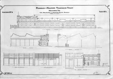
Drawing - Set of 3, Prahran & Malvern Tramway Trust (PMTT), "PMTT Malvern Depot", 1909 to 1920
... - showing additional buildings, floor plans, extensions... - showing additional buildings, floor plans, extensions ...Set of the three drawings of the Prahran and Malvern Tramways Trust (PMTT) Depot in Glenferrie Road, Malvern. 1 - Drawing No. 22 - Sheet No. 1 - Contract No. 8 - "Car shed offices and converter station buildings" - by Noyes Bros, dated 10/10/1909 2 - Drawing No. 23 - Sheet No. 2 - Contract No. 8 - Plan view of above - shows the first three roads or tracks within a larger building. Shows the room layout of the first depot building. 3 - Drawing No. 156 - Layout of Offices, car depot, and substation - c1920 - showing additional buildings, floor plans, extensions and the small four road workshop on the northside of Coldblo Road.Yields information about Malvern tram depot by the PMTT.Set of three prints on paper from a larger drawing reduced to A3 size.trams, tramways, depots, pmtt, malvern depot, drawings, noyes bros -
 Kew Historical Society Inc
Plan, Melbourne & Metropolitan Board of Works : Borough of Kew : Detail Plan No.1571, 1904
... Original survey plan, issued by the MMBW to a contractor... sections of buildings on the plan were used to denote masonry ...The Melbourne and Metropolitan Board of Works (MMBW) plans were produced from the 1890s to the 1950s. They were crucial to the design and development of Melbourne's sewerage and drainage system. The plans, at a scale of 40 feet to 1 inch (1:480), provide a detailed historical record of Melbourne streetscapes and environmental features. Each plan covers one or two street blocks (roughly six streets), showing details of buildings, including garden layouts and ownership boundaries, and features such as laneways, drains, bridges, parks, municipal boundaries and other prominent landmarks as they existed at the time each plan was produced. (Source: State Library of Victoria)This plan forms part of a large group of MMBW plans and maps that was donated to the Society by the Mr Poulter, City Engineer of the City of Kew in 1989. Within this collection, thirty-five hand-coloured plans, backed with linen, are of statewide significance as they include annotations that provide details of construction materials used in buildings in the first decade of the 20th century as well as additional information about land ownership and usage. The copies in the Public Record Office Victoria and the State Library of Victoria are monochrome versions which do not denote building materials so that the maps in this collection are invaluable and unique tools for researchers and heritage consultants. A number of the plans are not held in the collection of the State Library of Victoria so they have the additional attribute of rarity.Original survey plan, issued by the MMBW to a contractor with responsibility for constructing sewers in the area identified on the plan within the Borough of Kew. The plan was at some stage hand-coloured, possibly by the contractor, but more likely by officers working in the Engineering Department of the Borough and later Town, then City of Kew. The hand-coloured sections of buildings on the plan were used to denote masonry or brick constructions (pink), weatherboard constructions (yellow), and public buildings (grey). This plan is the other half of Plan No.1571 representing the constructions to the west of Wellington Street before and in 1903/4. This plan represents the built environment in Edgevale Road, Wellington Street, Atkins Street, Annadale Street, Mortimer Street, and Cotham Road. Whereas there are smaller allotments and more modest housing stock facing Edgevale Road, larger blocks and more substantial houses are represented facing Cotham Road.melbourne and metropolitan board of works, detail plans, mmbw 1571, cartography -
 National Wool Museum
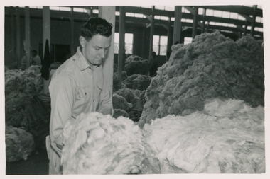
Photograph - Denny Lecelles Photographs, c1950
... was the first building in Victorian planned to facilitate storage... Warehouse was the first building in Victorian planned to facilitate ...Father of the donor, Mervyn Graham, worked for Denny Lascelles for many years as a wool classer in Geelong and later as a representative in Hamilton. The Denny Lascelles Wool Warehouse was the first building in Victorian planned to facilitate storage, inspection and marketing of wool in one operation, and upon completion was the second largest store in the colony. CJ Denny's was largely responsible for establishment and development of the wool marketing industry in Geelong and is a figure of significance in the history of settlement in Geelong.Black and white photos showcase different rooms of the Denny Lascelles building and the process of classing the wool within the store, from classing the wool to packaging and transportation.8080.7 - On wool press - Made by Johns & Waygood LTD. Melbourne Australia 8080.10 - On truck - Blackiston & Co PTY. LTD. Road transporters. Geelong & Melb.denny lascelles, geelong, wool, wool class, transportation -
 Vision Australia
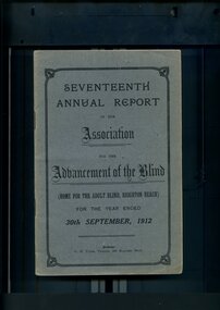
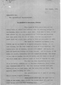
Administrative record - Text, Seventeenth Annual Report of the Association for the Advancement of the Blind 1912, 1912
... sufficient funds to reconstruct a wing to the present brick building... to reconstruct a wing to the present brick building, and plans are being ...Annual report of the Association for the Advancement of the Blind outlined activities and events over the year, including membership of 333, with the support of Mrs W.H. Edgar and the Lady Mayoress of Melbourne, 'Woodburn' was purchased and there were sufficient funds to reconstruct a wing to the present brick building, and plans are being drawn up under the supervision of Mr Paterson for some necessary extensions, the North Melbourne and Essendon Electric Tramway and Northcote Cable Tramway were added to the Railway Pass concession scheme, a successful concert tour was made of the Goulburn Valley from Alexandra down to the Murray, the loss of Mr Bacon - who was the first Blind Collector appointed by the Association - and Mrs May Harrison, VABW secretary who tirelessly promoted the welfare of the blind.1 volume of printed material with some illustrationsassociation for the advancement of the blind, annual reports -
 Kew Historical Society Inc
Plan, Melbourne & Metropolitan Board of Works : Borough of Kew : Detail Plan No.1592, 1905
... Original survey plan, issued by the MMBW to a contractor... The Melbourne and Metropolitan Board of Works (MMBW) plans were produced ...The Melbourne and Metropolitan Board of Works (MMBW) plans were produced from the 1890s to the 1950s. They were crucial to the design and development of Melbourne's sewerage and drainage system. The plans, at a scale of 40 feet to 1 inch (1:480), provide a detailed historical record of Melbourne streetscapes and environmental features. Each plan covers one or two street blocks (roughly six streets), showing details of buildings, including garden layouts and ownership boundaries, and features such as laneways, drains, bridges, parks, municipal boundaries and other prominent landmarks as they existed at the time each plan was produced. (Source: State Library of Victoria). This plan forms part of a large group of MMBW plans and maps that was donated to the Society by the Mr Poulter, City Engineer of the City of Kew in 1989. Within this collection, thirty-five hand-coloured plans, backed with linen, are of statewide significance as they include annotations that provide details of construction materials used in buildings in the first decade of the 20th century as well as additional information about land ownership and usage. The copies in the Public Record Office Victoria and the State Library of Victoria are monochrome versions which do not denote building materials so that the maps in this collection are invaluable and unique tools for researchers and heritage consultants. A number of the plans are not held in the collection of the State Library of Victoria so they have the additional attribute of rarity.Original survey plan, issued by the MMBW to a contractor with responsibility for constructing sewers in the area identified on the plan within the Borough of Kew. The plan was at some stage hand-coloured, possibly by the contractor, but more likely by officers working in the Engineering Department of the Borough and later Town, then City of Kew. The hand-coloured sections of buildings on the plan were used to denote masonry or brick constructions (pink), weatherboard constructions (yellow), and public buildings (grey). In MMBW Plan No.1592, the pink line indicates that area of the plan for which the contracting engineer was responsible. Included in the Plan are a number of primarily brick villas in a section of Belmont Avenue off Cotham Road. The house ‘Uvadale’ north of Belmont Avenue, and facing Cotham Road is also included in the contract. Excluded from the contract but shown on the Plan are ‘Glendonald’, ‘Mont Belmont’ and ‘Gilden’.melbourne and metropolitan board of works, detail plans, survey plans - borough of kew, mmbw 1592, cartography -
 Kew Historical Society Inc
Plan, Melbourne & Metropolitan Board of Works : Borough of Kew : Detail Plan No.1561, 1905
... Original survey plan, issued by the MMBW to a contractor... sections of buildings on the plan were used to denote masonry ...The Melbourne and Metropolitan Board of Works (MMBW) plans were produced from the 1890s to the 1950s. They were crucial to the design and development of Melbourne's sewerage and drainage system. The plans, at a scale of 40 feet to 1 inch (1:480), provide a detailed historical record of Melbourne streetscapes and environmental features. Each plan covers one or two street blocks (roughly six streets), showing details of buildings, including garden layouts and ownership boundaries, and features such as laneways, drains, bridges, parks, municipal boundaries and other prominent landmarks as they existed at the time each plan was produced. (Source: State Library of Victoria). This plan forms part of a large group of MMBW plans and maps that was donated to the Society by Mr Poulter, City Engineer of the City of Kew in 1989. Within this collection, thirty-five hand-coloured plans, backed with linen, are of statewide significance as they include annotations that provide details of construction materials used in buildings in the first decade of the 20th century as well as additional information about land ownership and usage. The copies in the Public Record Office Victoria and the State Library of Victoria are monochrome versions which do not denote building materials so that the maps in this collection are invaluable and unique tools for researchers and heritage consultants. A number of the plans are not held in the collection of the State Library of Victoria so they have the additional attribute of rarity.Original survey plan, issued by the MMBW to a contractor with responsibility for constructing sewers in the area identified on the plan within the Borough of Kew. The plan was at some stage hand-coloured, possibly by the contractor, but more likely by officers working in the Engineering Department of the Borough and later Town, then City of Kew. The hand-coloured sections of buildings on the plan were used to denote masonry or brick constructions (pink), weatherboard constructions (yellow), and public buildings (grey). MMBW Detail Plan 1561 outlines those residences in the area bordered by Burke Road, Loxton Street, Mount Street and Barkers Road that had been constructed by 1905 when the land was surveyed. At this time, the area nearest Burke Road had been subdivided and developed whereas the lands to the west were as yet undeveloped. The houses represented are not named on the Plan.melbourne and metropolitan board of works, detail plans, mmbw 1561, cartography -
 National Wool Museum
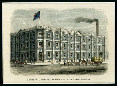
Newspaper Cutting, Messrs. C. J. Dennys and Co.'s New Wool Store Geelong, 10/9/1872
... The Denny Lascelles Wool Warehouse was the first building... building in Victorian planned to facilitate storage, inspection ...The Denny Lascelles Wool Warehouse was the first building in Victorian planned to facilitate storage, inspection and marketing of wool in one operation, and upon completion was the second largest store in the colony. CJ Denny's was largely responsible for establishment and development of the wool marketing industry in Geelong and is a figure of significance in the history of settlement in Geelong. The wool store, a basalt structure with cement rendered ornamentation, was erected for CJ Denny's and Co, in 1872 to the design of Jacob Pitman, Architect.Wood cut engraving of the Mesrs. C. J. Dennys and Co.'s New Wool Store Geelong, published in The Illustrated Australian News, 1872. The half page full colour illustration shows the newly constructed Wool Store with a bull drawn cart carrying full wool bales situated out the front of the store.Top margin: THE ILLUSTRATED AUSTRALIAN NEWS 201 Below image: Mesrs. C. J. Dennys and Co.'s New Wool Store Geelong Image signed, lower mid edge: WINSTON Image, on building: C.J. Dennys Wool Brokers 1872 C.J. Dennys & Co. Wool & Produce Warehousedenny lascelles wool warehouse, wool, dennys, wool store -
 Bendigo Historical Society Inc.
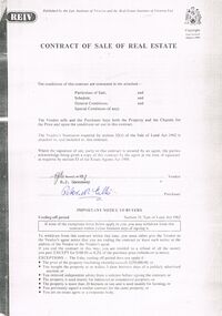
Document - PETER ELLIS COLLECTION: CONTRACT OF SALE
... , Planning Certificate Request for Building Approval Particulars... Information Certificate, Planning Certificate Request for Building ...Copy of Contract of Sale of Real Estate and associated papers for property located in Flora Lane, Flora Hill which was purchased by Peter Ellis on 26 May 1993. Contract is in booklet with other loose papers. Contract includes General Conditions, Particulars of Sale, Special Conditions, Guarantee, Vendors Statement to the Purchaser, Shire of Strathfieldsaye Land Information Certificate, Planning Certificate Request for Building Approval Particulars, Coliban Region Water Authority Information Statement, Property Inquiry Application Form, Request for Property Information from Vic roads, Advice on Mine Subsidence Hazard (Department of Energy & Minerals), Map, Copy of Certificate of Title and Folder Numbers. Loose pages include Building Control Act 1981 Inspection Notice, two plans of building, Three plans (Coliban Water Asset Location) of Flora Lane where property is situated, 2 dated 13/11/2007 (have New Carport drawn beside house) and 1 dated 22/11/2007. Last page has specifications for car port.bendigo, house, peter ellis oam, peter ellis collection, reiv, law institute of victoria, real estate institute of victoria ltd, e j gannaway, peter n ellis, ray white bendigo pty ltd, e m monotti & son, rogers and every, craig watts, shire of strathfieldsaye, coliban region water authority, sec, g & fc of vic, telecom, vicroads, bruce l phillips, k deps?, department of energy and minerals, robert james sanderson, t flanagan, land titles office victoria, harston partridge & co pty ltd -
University of Melbourne, Burnley Campus Archives
Plan (item) - Plans Burnley Gardens, Department of Agriculture - Victoria Burnley Gardens
... 1. Plan showing buildings labelled Projects No. 1 and 2...1. Plan showing buildings labelled Projects No. 1 and 2 ... -
 Kew Historical Society Inc
Plan, Melbourne & Metropolitan Board of Works : Borough of Kew : Detail Plan No.1570, 1905
... Original survey plan, issued by the MMBW to a contractor... sections of buildings on the plan were used to denote masonry ...The Melbourne and Metropolitan Board of Works (MMBW) plans were produced from the 1890s to the 1950s. They were crucial to the design and development of Melbourne's sewerage and drainage system. The plans, at a scale of 40 feet to 1 inch (1:480), provide a detailed historical record of Melbourne streetscapes and environmental features. Each plan covers one or two street blocks (roughly six streets), showing details of buildings, including garden layouts and ownership boundaries, and features such as laneways, drains, bridges, parks, municipal boundaries and other prominent landmarks as they existed at the time each plan was produced. (Source: State Library of Victoria)This plan forms part of a large group of MMBW plans and maps that was donated to the Society by the Mr Poulter, City Engineer of the City of Kew in 1989. Within this collection, thirty-five hand-coloured plans, backed with linen, are of statewide significance as they include annotations that provide details of construction materials used in buildings in the first decade of the 20th century as well as additional information about land ownership and usage. The copies in the Public Record Office Victoria and the State Library of Victoria are monochrome versions which do not denote building materials so that the maps in this collection are invaluable and unique tools for researchers and heritage consultants. A number of the plans are not held in the collection of the State Library of Victoria so they have the additional attribute of rarity.Original survey plan, issued by the MMBW to a contractor with responsibility for constructing sewers in the area identified on the plan within the Borough of Kew. The plan was at some stage hand-coloured, possibly by the contractor, but more likely by officers working in the Engineering Department of the Borough and later Town, then City of Kew. The hand-coloured sections of buildings on the plan were used to denote masonry or brick constructions (pink), weatherboard constructions (yellow), and public buildings (grey). Plan No.1570 shows the layout of gardens and houses in Sackville Street, Davis Street, Wrixon Street, and Fitzwilliam Street in 1904. While Thomas Street is included on the map, at this stage no houses had been built. The plan identifies two named houses: ‘Fairview’ and ‘Kylemore’. Fairview is more fully delineated in Plan No.1563. Kylemore is one of the few houses in Kew designed by John Beswicke. The most notable owner of Kylemore was William Whitehead, who owned the house between 1895 and 1900. In 1894, Australian newspapers reported the marriage of Whitehead’s daughter to Dr. Gerald Eugene Cussen, the brother of Sir Leo Cussen, the Supreme Court Judge. The married couple was to live at ‘Wilton’ (now the Kew RSL) from 1911-15.melbourne and metropolitan board of works, detail plans, mmbw 1570, cartography -
 Kew Historical Society Inc
Plan, Melbourne & Metropolitan Board of Works : Borough of Kew : Detail Plan No.1572, 1905
... Original survey plan, issued by the MMBW to a contractor... sections of buildings on the plan were used to denote masonry ...The Melbourne and Metropolitan Board of Works (MMBW) plans were produced from the 1890s to the 1950s. They were crucial to the design and development of Melbourne's sewerage and drainage system. The plans, at a scale of 40 feet to 1 inch (1:480), provide a detailed historical record of Melbourne streetscapes and environmental features. Each plan covers one or two street blocks (roughly six streets), showing details of buildings, including garden layouts and ownership boundaries, and features such as laneways, drains, bridges, parks, municipal boundaries and other prominent landmarks as they existed at the time each plan was produced. (Source: State Library of Victoria)This plan forms part of a large group of MMBW plans and maps that was donated to the Society by the Mr Poulter, City Engineer of the City of Kew in 1989. Within this collection, thirty-five hand-coloured plans, backed with linen, are of statewide significance as they include annotations that provide details of construction materials used in buildings in the first decade of the 20th century as well as additional information about land ownership and usage. The copies in the Public Record Office Victoria and the State Library of Victoria are monochrome versions which do not denote building materials so that the maps in this collection are invaluable and unique tools for researchers and heritage consultants. A number of the plans are not held in the collection of the State Library of Victoria so they have the additional attribute of rarity.Original survey plan, issued by the MMBW to a contractor with responsibility for constructing sewers in the area identified on the plan within the Borough of Kew. The plan was at some stage hand-coloured, possibly by the contractor, but more likely by officers working in the Engineering Department of the Borough and later Town, then City of Kew. The hand-coloured sections of buildings on the plan were used to denote masonry or brick constructions (pink), weatherboard constructions (yellow), and public buildings (grey). Plan No. 1572 represents the built environment bordered by Barkers Road, Wrixon Street, Edgevale Road and Fitzwilliam Street. Other streets identified on the plan include Stansell Street. Plan 1572 shows that by 1903-05, there was only patchy development in this area of Kew, mainly on Edgevale Road and Fitzwilliam Street. Only two named houses are identified: the quaintly named ‘Tweed Cottage’, and ‘Mendip’. The earliest reference to Treed Cottage in Australian newspapers is to the death of Walter Thompson, aged 74 who was a resident there in 1885. His youngest daughter was to die there in 1908. Mendip to the north of Tweed Cottage was owned by Henry Thompson; he was to die in 1901; his wife in 1932. At this period of time, Malin Street and Clivedon Court did not extend to Barkers Road.melbourne and metropolitan board of works, detail plans, mmbw 1572, cartography -
 Bendigo Historical Society Inc.
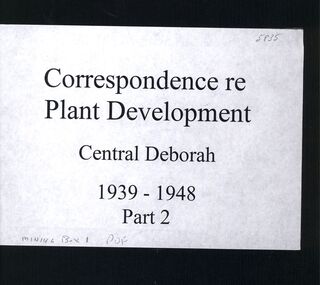
Book - CENTRAL DEBORAH MINE CORRESPONDENCE RE PLANT DEVELOPMENT PART 2
... . Building Site Plan. Abbott Supply Co. F.W. Milne & Son. The Golden... Exchange. Building Site Plan. Abbott Supply Co. F.W. Milne & Son ...Black folder containing photocopied documents pertaining to the setting up and running of the Central Deborah Mine, Bendigo. 1939 - 1948. Original copies held in McColl,Rankin & Stanistreet Collection. Application for Permit. Ministry of Post War Reconstruction. War Organisation of Industry. Quotes, Tenders. Hume & Iser. T.J Jorgensen. Electricity Supply Department. Saunders & Ross. District Telephone Office. R Toma. Stock Exchange. Building Site Plan. Abbott Supply Co. F.W. Milne & Son. The Golden City Agricultural Implements. Department of Labour and National Service.Miller & Co. Thompson Engineering and Pipe Co. Gold Boring and Prospecting. Costs. J.l. Howard. A.J. William Electrical Instruments.bendigo, mining, central deborah gold mine -
 University of Melbourne, Burnley Campus Archives
Work on paper (Item), Stockman's Residence
... enclosing 2 rough plans of proposed building (1940). Blueprint... building (1940). Blueprint of plan by Chief Architect of Stockman's ...Handwritten note on back of government form stating that plans were found in a plan press in PWDstockman's residence, plans, a.w. jessep -
 Kew Historical Society Inc
Plan, Melbourne & Metropolitan Board of Works : Borough of Kew : Detail Plan No.1578, 1904
... , the plan clarifies which buildings the High School operated from...-coloured sections of buildings on the plan were used to denote ...The Melbourne and Metropolitan Board of Works (MMBW) plans were produced from the 1890s to the 1950s. They were crucial to the design and development of Melbourne's sewerage and drainage system. The plans, at a scale of 40 feet to 1 inch (1:480), provide a detailed historical record of Melbourne streetscapes and environmental features. Each plan covers one or two street blocks (roughly six streets), showing details of buildings, including garden layouts and ownership boundaries, and features such as laneways, drains, bridges, parks, municipal boundaries and other prominent landmarks as they existed at the time each plan was produced. (Source: State Library of Victoria). This plan forms part of a large group of MMBW plans and maps that was donated to the Society by the Mr Poulter, City Engineer of the City of Kew in 1989. Within this collection, thirty-five hand-coloured plans, backed with linen, are of statewide significance as they include annotations that provide details of construction materials used in buildings in the first decade of the 20th century as well as additional information about land ownership and usage. The copies in the Public Record Office Victoria and the State Library of Victoria are monochrome versions which do not denote building materials so that the maps in this collection are invaluable and unique tools for researchers and heritage consultants. A number of the plans are not held in the collection of the State Library of Victoria so they have the additional attribute of rarity.Original survey plan, issued by the MMBW to a contractor with responsibility for constructing sewers in the area identified on the plan within the Borough of Kew. The plan was at some stage hand-coloured, possibly by the contractor, but more likely by officers working in the Engineering Department of the Borough and later Town, then City of Kew. The hand-coloured sections of buildings on the plan were used to denote masonry or brick constructions (pink), weatherboard constructions (yellow), and public buildings (grey). MMBW Plan No.1578 is significant in that it defines the extent of two private schools: Xavier College and Kew High School (now part of Trinity Grammar) by 1904. In relation to the latter, the plan clarifies which buildings the High School operated from behind the mansion ‘Molina’. Established in 1902, Trinity Grammar was to later lease and subsequently buy Molina (now ‘Merritt House’) and ‘Elsinore’ (now ‘Roberts House’). Xavier College had been established in 1872. This 1904 plan delineates the West Wing and the Great Hall (built in 1890).melbourne and metropolitan board of works, detail plans, maps - borough of kew, mmbw 1578, cartography -
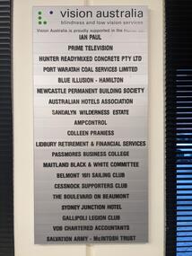 Vision Australia
Photograph - Image, Mel Robbins, Plaques at Newcastle office
... Drayton Building & Construction The Plan Centre Hunter Land... Advisors Corporation Drayton Building & Construction The Plan... Drayton Building & Construction The Plan Centre Hunter Land Vision ...Silver plaque with black writing mounted on board inside black frame, and silver plaque with black writing. Both list the companies that financially supported the Newcastle office for Vision Australia (formerly the Royal Blind Society of New South Wales). The first plaque reads: Vision Australia Blindness and low vision services Vision Australia is proudly supported in the Hunter by: Ian Paul Prime Television Hunter Readymixed Concrete Pty Ltd Port Waratah Coal Services Limited Blue Illusion - Hamilton Newcastle Permanent Building Society Australian Hotels Association Sandalyn Wilderness Estate AmpControl Colleen Praniess Lidbury Retirement & Financial Services Passmores Business College Maitland Black & White Committee Belmont 16ft Sailing Club Cessnock Supporters Club The Boulevard on Beaumont Sydney Junction Hotel Gallipoli Legion Club VDB Chartered Accountants Salvation Army - McIntosh Trust The second plaque reads: Royal Blind Society vision to share This Client Service Centre was made possible thanks to generous support from Ian Paul as well as the following organisations Prime Television Newcastle Knights Hunter Water Western Suburbs (Newcastle) Leagues Club Management Advisors Corporation Drayton Building & Construction The Plan Centre Hunter Land2 images of plaques displayed at the Newcastle officeVision Australia Blindness and low vision services Vision Australia is proudly supported in the Hunter by: Ian Paul Prime Television Hunter Readymixed Concrete Pty Ltd Port Waratah Coal Services Limited Blue Illusion - Hamilton Newcastle Permanent Building Society Australian Hotels Association Sandalyn Wilderness Estate AmpControl Colleen Praniess Lidbury Retirement & Financial Services Passmores Business College Maitland Black & White Committee Belmont 16ft Sailing Club Cessnock Supporters Club The Boulevard on Beaumont Sydney Junction Hotel Gallipoli Legion Club VDB Chartered Accountants Salvation Army - McIntosh Trust Royal Blind Society vision to share This Client Service Centre was made possible thanks to generous support from Ian Paul as well as the following organisations Prime Television Newcastle Knights Hunter Water Western Suburbs (Newcastle) Leagues Club Management Advisors Corporation Drayton Building & Construction The Plan Centre Hunter Landvision australia, royal blind society of nsw, plaques -
Bialik College
Mixed media (series) - Early Learning Centre
... Centre building, including slides of plans, an album... Centre building, including slides of plans, an album ...elc, 1990s, 2000selc, 1990s, 2000s -
 Federation University Historical Collection
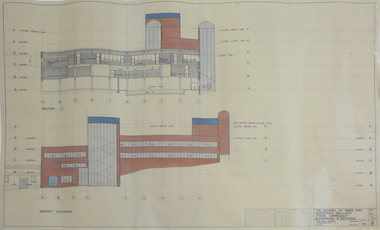
Plan - Plans, Ballarat School of Mines Albert Street Buildings, 1979
... buildings: .1) Locality Plan .2) Trade Workshop Site Plan .3) Trade..., and later housed Ballarat Tech. building plans smb trade workshops ...The Trade Workshops became known as the M.B. John Building, and later housed Ballarat Tech.Eight printed plans with coloured shading of SMB Albert St buildings: .1) Locality Plan .2) Trade Workshop Site Plan .3) Trade Workshop Floor Plan Level A & B .4) Trade Workshop Floor Plan Level C .5) Trade Workshop Floor Plan Level D .6) Trade Workshop Floor Plan Level E .7) Trade Workshop West Elevation and Sections .8) Trade Workshop North Elevations and Sections building plans, smb trade workshops, ewan jones and associates pty ltd, architectural plan, m.b. john building, albert street -
 Melbourne Tram Museum
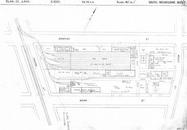
Drawing, Melbourne & Metropolitan Tramways Board (MMTB), "South Melbourne Depot", c1937
... detail of tram shed and adjacent buildings .4 - P8348 - Plan... detail of tram shed and adjacent buildings .4 - P8348 - Plan ...Set of five photocopied plans or drawings on A3 sheet of "South Melbourne Depot" - c 1937 .1 - P8345 - Plan of land showing MMTB land and surrounding properties. .2 - P8346 - Plan of land showing detail of offices .3 - P8347 - Plan showing detail of tram shed and adjacent buildings .4 - P8348 - Plan showing detail of buildings along the side of the block. .5 - P8349 - Plan showing details of the per way yard and associated facilities.trams, tramways, drawings, depots, property, south melbourne depot -
 Kew Historical Society Inc
Plan, Melbourne and Metropolitan Board of Works, Borough of Kew : Detail Plan No.1562, 1905
... Original survey plan, issued by the MMBW to a contractor... sections of buildings on the plan were used to denote masonry ...The Melbourne and Metropolitan Board of Works (MMBW) plans were produced from the 1890s to the 1950s. They were crucial to the design and development of Melbourne's sewerage and drainage system. The plans, at a scale of 40 feet to 1 inch (1:480), provide a detailed historical record of Melbourne streetscapes and environmental features. Each plan covers one or two street blocks (roughly six streets), showing details of buildings, including garden layouts and ownership boundaries, and features such as laneways, drains, bridges, parks, municipal boundaries and other prominent landmarks as they existed at the time each plan was produced. (Source: State Library of Victoria). This plan forms part of a large group of MMBW plans and maps that was donated to the Society by the Mr Poulter, City Engineer of the City of Kew in 1989. Within this collection, thirty-five hand-coloured plans, backed with linen, are of statewide significance as they include annotations that provide details of construction materials used in buildings in the first decade of the 20th century as well as additional information about land ownership and usage. The copies in the Public Record Office Victoria and the State Library of Victoria are monochrome versions which do not denote building materials so that the maps in this collection are invaluable and unique tools for researchers and heritage consultants. A number of the plans are not held in the collection of the State Library of Victoria so they have the additional attribute of rarity.Original survey plan, issued by the MMBW to a contractor with responsibility for constructing sewers in the area identified on the plan within the Borough of Kew. The plan was at some stage hand-coloured, possibly by the contractor, but more likely by officers working in the Engineering Department of the Borough and later Town, then City of Kew. The hand-coloured sections of buildings on the plan were used to denote masonry or brick constructions (pink), weatherboard constructions (yellow), and public buildings (grey). MMBW detail plan No.1562, in contrast to No.1561 includes the names of a large number of houses: in Barkers Road: ‘Ashwick’, ‘Owasso’, ‘Anadiha’, ‘Eurobin’, ‘Carlsruhe’, ‘Arlington’ and ‘Altyre’. Unnamed but clearly represented on the plan is what was then known as the ‘Auburn Heights Recreation Club’, which at this stage included a Bowling Green, a Croquet Green and two Tennis Courts. On the plan, Brougham Place, as it was then known, is represented. It was later renamed Daniell Place. The aforementioned Arlington is now the junior campus of Preshil. melbourne and metropolitan board of works, detail plans, mmbw 1562, cartography -
 Kew Historical Society Inc
Plan, Melbourne & Metropolitan Board of Works : Borough of Kew : Detail Plan No.1350, 1910
... Original survey plan, issued by the MMBW to a contractor... sections of buildings on the plan were used to denote masonry ...The Melbourne and Metropolitan Board of Works (MMBW) plans were produced from the 1890s to the 1950s. They were crucial to the design and development of Melbourne's sewerage and drainage system. The plans, at a scale of 40 feet to 1 inch (1:480), provide a detailed historical record of Melbourne streetscapes and environmental features. Each plan covers one or two street blocks (roughly six streets), showing details of buildings, including garden layouts and ownership boundaries, and features such as laneways, drains, bridges, parks, municipal boundaries and other prominent landmarks as they existed at the time each plan was produced. (Source: State Library of Victoria). This plan forms part of a large group of MMBW plans and maps that was donated to the Society by the Mr Poulter, City Engineer of the City of Kew in 1989. Within this collection, thirty-five hand-coloured plans, backed with linen, are of statewide significance as they include annotations that provide details of construction materials used in buildings in the first decade of the 20th century as well as additional information about land ownership and usage. The copies in the Public Record Office Victoria and the State Library of Victoria are monochrome versions which do not denote building materials so that the maps in this collection are invaluable and unique tools for researchers and heritage consultants. A number of the plans are not held in the collection of the State Library of Victoria so they have the additional attribute of rarity.Original survey plan, issued by the MMBW to a contractor with responsibility for constructing sewers in the area identified on the plan within the Borough of Kew. The plan was at some stage hand-coloured, possibly by the contractor, but more likely by officers working in the Engineering Department of the Borough and later Town, then City of Kew. The hand-coloured sections of buildings on the plan were used to denote masonry or brick constructions (pink), weatherboard constructions (yellow), and public buildings (grey). MMBW Plan No. 1350 depicts the western end of Studley Park on the north side of the Studley Park Road. ‘Raheen’, then the home of Sir Henry Wrixon is named, the plan identifying those parts of the house that were built of brick and timber. The two houses between Raheen and the River Yarra are also shown. Other parts of the plan show neighbouring streets: Yarra Street, Studley Park Avenue, Studley Street and Fenwick Street. Each, apart from Fenwick Street was subsequently renamed. At the corner of Fenwick and Stawell Streets, the home of Joseph Butterworth Coombs, later called ‘Hope Mansell’, is represented but unnamed.melbourne and metropolitan board of works, detail plans, mmbw 1350, cartography -
 Kew Historical Society Inc
Plan, Melbourne & Metropolitan Board of Works : Borough of Kew : Detail Plan No.1565, 1905
... Original survey plan, issued by the MMBW to a contractor... sections of buildings on the plan were used to denote masonry ...The Melbourne and Metropolitan Board of Works (MMBW) plans were produced from the 1890s to the 1950s. They were crucial to the design and development of Melbourne's sewerage and drainage system. The plans, at a scale of 40 feet to 1 inch (1:480), provide a detailed historical record of Melbourne streetscapes and environmental features. Each plan covers one or two street blocks (roughly six streets), showing details of buildings, including garden layouts and ownership boundaries, and features such as laneways, drains, bridges, parks, municipal boundaries and other prominent landmarks as they existed at the time each plan was produced. (Source: State Library of Victoria). This plan forms part of a large group of MMBW plans and maps that was donated to the Society by the Mr Poulter, City Engineer of the City of Kew in 1989. Within this collection, thirty-five hand-coloured plans, backed with linen, are of statewide significance as they include annotations that provide details of construction materials used in buildings in the first decade of the 20th century as well as additional information about land ownership and usage. The copies in the Public Record Office Victoria and the State Library of Victoria are monochrome versions which do not denote building materials so that the maps in this collection are invaluable and unique tools for researchers and heritage consultants. A number of the plans are not held in the collection of the State Library of Victoria so they have the additional attribute of rarity.Original survey plan, issued by the MMBW to a contractor with responsibility for constructing sewers in the area identified on the plan within the Borough of Kew. The plan was at some stage hand-coloured, possibly by the contractor, but more likely by officers working in the Engineering Department of the Borough and later Town, then City of Kew. The hand-coloured sections of buildings on the plan were used to denote masonry or brick constructions (pink), weatherboard constructions (yellow), and public buildings (grey). MMBW Plan No.1565 is an example of a plan where a number of streets have been created since the area was surveyed, or in other cases renamed. The plan shows those streets that were bordered by Ross Street, Mount Street, Sackville Street and Burke Road. Since 1905, Mawson Street has been created and Mont Albert Road renamed as Dean Street. Named houses on the plan include ‘Tyrol’, ‘Glengorse’, ‘Theodore Villa’, ‘Arncliffe’, ‘Ballynira’ and ‘Hazeldene’. The plan also shows a Wesleyan Church in Sackville Street. In 1883, the Church’s Sunday School celebrated its silver anniversary.melbourne and metropolitan board of works, detail plans, mmbw 1565, cartography