Showing 2338 items
matching cape-otway
-
 Flagstaff Hill Maritime Museum and Village
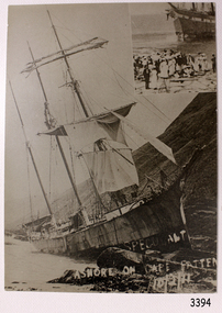
Photograph, c 10th February 1911
This photograph was taken after the SPECULANT was wrecked at Cape Patton, Victoria. It is uncertain which ship is in the photograph insert to the the top right hand corner of this photograph. The barquentine SPECULANT was a steel, three-masted sailing ship built in 1895 in Inverkeithing, Scotland, registered in Warrnambool, Victoria and wrecked at Cape Paton, Victoria, 10th February 1911. The SPECULANT had been involved in the timber trade between the United Kingdom and Russia, until sold to its Warrnambool owners and timber merchants Messrs. P.J. McGennan & Co. (Peter John McGennan) in 1902 for 3000 pounds and had her sailed to Warrnambool as her new port. Peter John McGennan was born in 1844 and worked as a builder and cooper in Holyhead, Anglesea, Wales. He immigrated to Australia in 1869 as a free settler and arrived in Warrnambool in 1871 and undertook management of a property in Grassmere for Mr. Palmer. Peter met his wife Emily in South Melbourne and they married in 1873. They had ten children including Harry who lived to 1965, and Andrew who lived until 1958. (The other children were their four brothers - John who was killed in the Dardenalles aged 35, Frederick who died aged 8, Peter who died aged 28, Frank who died aged 5 weeks - and four sisters - Beatrice who died age 89, Edith who died aged 49, Blanche who died aged 89 and Eveline who died aged 48.) In 1874 Peter starting a boating establishment on the Hopkins River. In 1875 he opened up a Coopers business in Kepler Street next to what was Bateman, Smith and Co., moving to Liebig Street, next to the Victoria Hotel, in 1877. In 1882 he then moved to Lava Street (which in later years was the site of Chandlers Hardware Store). He was associated with the establishment of the Butter Factory at Allansford. He started making Butter Boxes to his own design and cheese batts for the Butter Factory. In 1896 established a Box Factory in Davis Street Merrivale, employing 24 people at its peak, (it was burnt down in 1923); and in Pertobe Road from 1912 (now the Army Barracks building). Peter was a Borough Councillor for Albert Ward from 1885 to 1891, he commenced the Foreshore Trust (including the camping grounds along Pertobe Road), and he was an inaugural Director of the Woollen Mill in Harris Street, buying an extensive share-holding in 1908 from the share trader Edward Vidler. They lobbied the Town Hall to have a formal ‘Cutting’ for the waters of the Merri River to be redirected from its natural opening south of Dennington, to its existing opening near Viaduct Road, in order to have the scourings from the wool at the Woollen Mill discharged into the sea. He sold Butter Boxes around the state, and had to ship them to Melbourne by rail. Peter’s purchase of the SPECULANT in 1902 enabled him to back-load white pine from Kaipara, New Zealand to Warrnambool to make his butter boxes then, to gain profitability, buy and ship potatoes and other primary produce bound to Melbourne. (McGennan & Co. had also owned the LA BELLA, which had traded in timber as well, until she was tragically wrecked with the loss of seven lives, after missing the entrance channel to Warrnambool harbour in 1905. It appears that the SPECULANT was bought to replace the LA BELLA.) In 1911 the SPECULANT had been attempting to depart Warrnambool for almost the entire month of January to undergo docking and overhaul in Melbourne. A month of east and south-easterly winds had forced her to remain sheltered in Lady Bay, Warrnambool apart from one morning of northerlies, when an attempt was made to round Cape Otway; she had to return to shelter in Portland after failing to make any headway. With only 140 tons of sand ballast aboard, the ship would not have been easy to handle. Captain Jacobsen and his crew of nine, mainly Swedes, decided to make for Melbourne, leaving Portland Harbour on 5th February 1911. By the 9th they had reached Cape Otway, where they encountered a moonless night, constant heavy rain, and a heavy sea with a south-easterly wind blowing. After safely rounding Cape Otway the course was changed to east, then north-east to take the vessel to a point six miles off Cape Patton, following the orders of Captain Jacobsen, who told the crew to be very careful with the steering, as the wind and sea was running to leeward. The patent log (used to measure speed) had been out of order for the last four months as no-one in Warrnambool was able to fix it: it was intended to have it repaired in Melbourne. In the meantime the crew measured the vessel's speed by looking over the side and estimating wind strength. This compounded the difficulties of imprecise positioning, as the strong cross wind and sea were acting on the lightly laden vessel to steadily drive it towards the shore. At 3.30am on Friday 10 February 1911 Captain Jacobsen and the first mate were looking over the side of the vessel when they heard the sound of breakers and suddenly struck the rocks. The crew immediately knew they had no chance of getting the SPECULANT off, and attempted to rescue themselves by launching the lifeboat, which was instantly smashed to pieces. One of the crew then volunteered to take a line ashore, and the rest of the crew were all able to drag themselves to shore, some suffering hand lacerations from the rocks. Once ashore they began to walk along the coast towards Lorne, believing it was the nearest settlement. Realising their mistake as dawn broke they returned westwards to Cape Patton, and found a farm belonging to Mr C. Ramsden, who took them in and gave them a change of clothes and food. After resting for a day and returning to the wreck to salvage some of their personal possessions, at 10am on Saturday they set out for Apollo Bay, a voyage that took six hours, sometimes wading through flooded creeks up to their necks. The Age described the wreck as "listed to starboard. All the cabin is gutted and the ballast gone. There is a big rock right through the bottom of her, and there is not the slightest hope of getting her off". A Board of Marine inquiry found that Captain Jacobson was guilty of careless navigation by not taking steps to accurately verify the position of the vessel with respect to Cape Otway when the light was visible and by not setting a safe and proper course with respect to the wind and sea. It suspended his certificate for 6 months and ordered him to pay costs. The location of the wreck site was marked for a long time by two anchors on the shoreline, until in 1970 the larger of the two anchors was recovered by the Underwater Explorers' Club and mounted on the foreshore at Apollo Bay. The bell from the wreck was also donated to the Apollo Bay Surf Lifesaving Club but is recorded to have been stolen. Rusting remains of the wreck can still be found on the shoreline on the southern side of, and directly below Cape Patton. Parts of the SPECULANT site have been buried by rubble from construction and maintenance works to the Great Ocean Road, as well as by naturally occurring landslides. Peter J McGennan passed away in 1920. The Gates in the western wall of the Anglican Church in Henna Street/Koroit St are dedicated to him for his time of community work, which is matched with other prominent Warrnambool citizens; Fletcher Jones, John Younger, J.D.E (Tag) Walter, and Edward Vidler. After Peter J McGennan's death Harry, Andrew and Edith continued to operate the family business until July 11th 1923 when the company was wound up. (Andrew lived in Ryot Street Warrnambool, near Lava Street.) Harry McGennan (Peter and Emily’s son) owned the Criterion Hotel in Kepler Street Warrnambool (now demolished). His son Sid and wife Dot lived in 28 Howard Street (corner of Nelson Street) and Sid managed the Criterion until it was decided by the family to sell, and for he remained Manager for the new owners until he retired. Harry commenced the Foreshore Trust in Warrnambool around 1950. The McGennan Carpark in Pertobe Road is named after Harry and there are Memorial-Stone Gates in his memory. (The Gates were once the original entrance to the carpark but are now the exit.). Peter’s great-grandson, also called Andrew, is a Security Officer in Warrnambool. The Patent Log (also called a Taffrail log) from the SPECULANT, mentioned above, and a number of photographs, are now part of the Collection at Flagstaff Hill Maritime Village. The SPECULANT is historically significant as the largest ship to have been registered in Warrnambool, and is believed to have been the largest barquentine to visit Melbourne. It is evidence of the final days of large commercial sailing vessels involved in the Victorian and New Zealand timber trade. The SPECULANT is listed on the Victorian Heritage Register VHR S626Black and White photograph of the barquentine Speculant, on rocks at Cape Patton, steep hills in the background. A second photo in top right hand corner of a different ship aground, with a crowd in the foreground, Hand written in white on front of photograph "SPECULANT ASHORE ON CAPE PATTEN 10/2/11" (incorrect spelling of Cape Patton).Hand written in white on front of photograph "SPECULANT ASHORE ON CAPE PATTEN 10/2/11" flagstaff hill, warrnambool, shipwrecked-coast, flagstaff-hill, flagstaff-hill-maritime-museum, maritime-museum, shipwreck-coast, flagstaff-hill-maritime-village, photograph, speculant, cape patton, cumming and ellis, international timber trade, f. j. mcgennan and co. warrnambool, capt. james jacobsen, warrnambool maritime historyla bella, p. j. mcgennan and co. warrnambool, peter mcgennan, warrnambool maritime history, h. pengilley apollo bay, cape patton victoria, warrnambool historical photograph -
 Flagstaff Hill Maritime Museum and Village
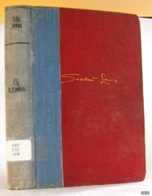
Book, Jonathan Cape, The Job, 1929
This book “The Job” is a novel written by Sinclair Lewis. It was first published in America in 1916 and in England in 1926. It is Lewis’ third book. There are 320 numbered pages, divided into three parts, each part is divided into chapters, which are in turn divided into sections. This particular book is one of a Collected Edition published in 1929. A note from the publisher included within the book states “It has been corrected in some small details but no revision or rewriting has been attempted by the author who wishes it to be made clear that it is an early and not a new work.” About SINCLAIR LEWIS (1885-1951) The author was born as Harry Sinclair Lewis in 1885 in Sauk Centre, Minnesota. He was renowned as an American novelist, playwright and short story writer. His first writings were romantic poems and short stories. Six of his novels were published by the time Lewis was 36. Lewis received the Nobel Prize for Literature in 1930 for his “vigorous and graphic art of description and his ability to create, with wit and humour, new types of characters." He was the first author from the United States to receive this award. Lewis graduated from university in 1907. He worked as a reporter and editor for several publications. He was a prolific writer, publishing dozens of works and numerous articles, and became popular for his satire. Lewis married and divorced twice and died alone from a heart attack due to advanced alcoholism) near Rome on 10th January 1951, aged 66. This book was part of a large group of books referred to as the Pattison Collection, which belonged to the Warrnambool Public Library, part of the Warrnambool Mechanics’ Institute. There is a remnant of the library’s label inside the back page of the book. About RALPH ERIC PATTISON and the ‘PATTISON COLLECTION’ The ‘Pattison Collection’ is a collection of books and records that was originally owned by the Warrnambool Mechanics’ Institute, founded in Warrnambool in 1853. By 1886 the Warrnambool Mechanics’ Institute (WMI) had grown to have a Library, Museum and Fine Arts Gallery, with a collection of “… choice productions of art, and valuable specimens in almost every branch and many wonderful national curiosities are now to be seen there, including historic relics of the town and district.” It later included a School of Design. Although it was very well patronised, the WMI was led to ask the City Council to take it over in 1911 due to lack of financial support. In 1935 Ralph Pattison was appointed as City Librarian to establish and organise the Warrnambool Public Library as it was then called. Ralph Eric Pattison was born in Rockhampton, Queensland, in 1891. He married Maude Swan from Warrnambool in 1920 and they set up home in Warrnambool. In 1935 when Pattison accepted the position as City Librarian for the Warrnambool City Council his huge challenge was to make a functional library within two rooms of the Mechanics’ Institute. He tirelessly cleaned, cleared and sorted a disarrayed collection of old books, jars of preserved specimens and other items reserved for exhibition in the city’s museum. He developed and updated the library with a wide variety of books for all tastes, including reference books for students; a difficult task to fulfil during the years following the Depression. He converted all of the lower areas of the building into a library, reference room and reading room for members and the public. The books were sorted and stored using a cataloguing and card index system that he had developed himself. He also prepared the upper floor of the building and established the Art Gallery and later the Museum, a place to exhibit the many old relics that had been stored for years for this purpose. One of the treasures he found was a beautiful ancient clock, which he repaired, restored and enjoyed using in his office during the years of his service there. Ralph Pattison was described as “a meticulous gentleman whose punctuality, floorless courtesy and distinctive neat dress were hallmarks of his character, and ‘his’ clock controlled his daily routine, and his opening and closing of the library’s large heavy doors to the minute.” Pattison took leave from 1942 to 1945 to serve in the Royal Australian Navy, Volunteer Reserve as Lieutenant. A few years later he converted one of the Museum’s rooms into a Children’s Library, stocking it with suitable books for the younger generation. This was an instant success. In the 1950’s he had the honour of being appointed to the Victorian Library Board and received more inspiration from the monthly conferences in Melbourne. He was sadly retired in 1959 after over 23 years of service, due to the fact that he had gone over the working age of council officers. However he continued to take a very keen interest in the continual development of the Library until his death in 1969. THE NEW WARRNAMBOOL LIBRARY When the WMI building was pulled down in 1963 a new civic building was erected on the site and the new Warrnambool Library, on behalf of the City Council, took over all the holdings of the WMI. At this time some of the items were separated and identified as the ‘Pattison Collection’, named after Pattison. Eventually the components of the WMI were distributed from the Warrnambool Library to various places, including the Art Gallery, Historical Society and Flagstaff Hill. Later some were even distributed to other regional branches of Corangamite Regional Library and passed to and fro. It is difficult now to trace just where all of the items have ended up. The books at Flagstaff Hill Maritime Village generally display stamps and markings from Pattison as well as a variety of other institutions including the Mechanics’ Institute itself. Lewis’s book is significant for its association with the writer, who was the first American to be awarded the Nobel Prize for Literature (1930). This book is significant for its connection with the Pattison Collection which, along with other items at Flagstaff Hill Maritime Village, was originally part of the Warrnambool Mechanics' Institute’s collection. The Warrnambool Mechanics’ Institute collection is primarily significant in its totality, rather than for the individual objects it contains. Its contents are highly representative of the development of Mechanics' Institute libraries across Australia, particularly Victoria. A diversity of publications and themes has been amassed, and these provide clues to our understanding of the nature of and changes in the reading habits of Victorians from the 1850s to the middle of the 20th century. The collection also highlights the Warrnambool community’s commitment to the Mechanics’ Institute, reading, literacy and learning in the regions, and proves that access to knowledge was not impeded by distance. These items help to provide a more complete picture of our community’s ideals and aspirations. The Warrnambool Mechanics Institute book collection has historical and social significance for its strong association with the Mechanics Institute movement and the important role it played in the intellectual, cultural and social development of people throughout the latter part of the nineteenth century and the early twentieth century. The collection of books is a rare example of an early lending library and its significance is enhanced by the survival of an original collection of many volumes. The Warrnambool Mechanics' Institute’s publication collection is of both local and state significance. Title: The Job Author: Sinclair Lewis Publisher: Jonathan Cape, London Date: 1929 Hardback board book covered with red linen, spine reinforced with blue. The author’s name is embossed in gold on the front cover. There is a logo impressed into the centre of the back cover with the printer’s initials “J C”. On the spine is a white adhesive label with a typed library call number. Inside the front cover is a printed label. Inside front and back covers are a black stamp and handwritten characters in pen and pencil. Inside the back cover and facing page are various date stamps dating from 1942 to 1963. The book, a novel, is one of a Collected Edition published in 1929. It also belongs to the Pattison Collection originally belonging to the Warrnambool Public Library.Logo “J” over “C” Adhesive label - “PAT / FIC / LEW” Printed label “Corangamite Regional Library Service / Warrnambool City Library / Pattison Collection” Stamp on inside front page and inside back page “CORANGAMITE REGIONAL LIBRARY SERVICE / WARRNAMBOOL LIBRARY” Handwritten on the inside page facing cover “1083” and “M 73” Handwritten on inside page facing back cover “1083” Date stamps facing back cover “1958” – “1963”, and on inside back cover “1942” – “195-“ Remnants of a torn out paper “ - - - - - - PU - - - C LIBRAR- / ……” flagstaff hill, warrnambool, shipwrecked coast, flagstaff hill maritime museum, maritime museum, shipwreck coast, flagstaff hill maritime village, great ocean road, book, pattison collection, warrnambool library, warrnambool public library, warrnambool mechanics’ institute, ralph eric pattison, warrnambool books and records, corangamite regional library service, warrnambool city librarian, mechanics’ institute library, victorian library board, warrnambool children’s library, the job by sinclair lewis, collection edition sinclair lewis, american novel 1929, jonathan cape, sinclair lewis, harry sinclair lewis, 1930 nobel prize for literature -
 Phillip Island and District Historical Society Inc.
Photograph, Bryant West
One of a collection of over 400 photographs in an album commenced in 1960 and presented to the Phillip Island & Westernport Historical Society by the Shire of Phillip IslandPhotograph of Rock Formation Cape Woolamai - The Elephants.local history, photography, photographs, coastline, cape woolamai, rock formations, phillip island, the elephants cape woolamai, john jenner, bryant west -
 Phillip Island and District Historical Society Inc.
Photograph, Bryant West
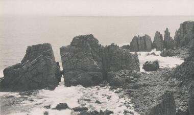
One of a collection of over 400 photographs in an album commenced in 1960 and presented to the Phillip Island & Westernport Historical Society by the Shire of Phillip IslandPhotograph of Rock Formation, Cape Woolamai - The Watchtower.local history, photography, photographs, coastline, cape woolamai, rock formations, phillip island, the watch tower cliffs, the watch tower cape woolamai, john jenner, bryant west -
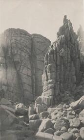
 Phillip Island and District Historical Society Inc.
Photograph, Bryant West
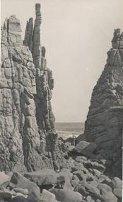
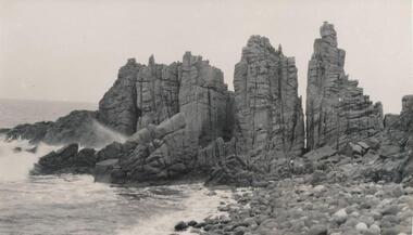
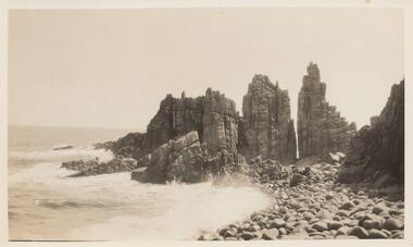
One of a collection of over 400 photographs in an album commenced in 1960 and presented to the Phillip Island & Westernport Historical Society by the Shire of Phillip IslandPhotograph of Rock Formation - Cape Woolamai - The Pinnacles.local history, photography, photographs, coastline, cape woolamai, phillip island, black & white photograph, rock formations, the pinnacles cape woolamai, john jenner, bryant west -
 Phillip Island and District Historical Society Inc.
Photograph, Bryant West
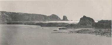
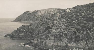
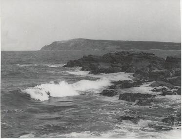
One of a collection of over 400 photographs in an album commenced in 1960 and presented to the Phillip Island & Westernport Historical Society by the Shire of Phillip IslandPhotograph of Cape Woolamai looking south east.local history, photography, photographs, coastline, cape woolamai, phillip island, john jenner, bryant west -
 Phillip Island and District Historical Society Inc.
Photograph, Bryant West
One of a collection of over 400 photographs in an album commenced in 1960 and presented to the Phillip Island & Westernport Historical Society by the Shire of Phillip IslandPhotograph of Gull Island adjoining Cape Woolamai.local history, photography, photographs, coastline, islands, cape woolamai, phillip island, black & white photograph, gull island cape woolamai, john jenner, bryant west -
 Phillip Island and District Historical Society Inc.
Photograph, Bryant West
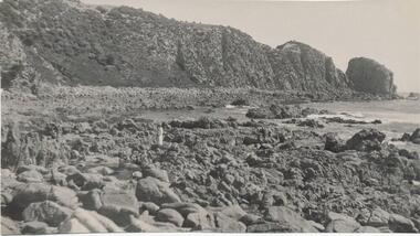
One of a collection of over 400 photographs in an album commenced in 1960 and presented to the Phillip Island & Westernport Historical Society by the Shire of Phillip IslandPhotograph of granite outcrops on the shoreline at Cape Woolamailocal history, photography, photographs, coastline - granite rocks - cape woolamai, coastline, granite outcrops, john jenner, bryant west -
 Phillip Island and District Historical Society Inc.
Photograph, Bryant West
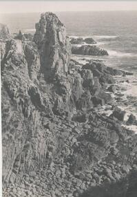
One of a collection of over 400 photographs in an album commenced in 1960 and presented to the Phillip Island & Westernport Historical Society by the Shire of Phillip IslandPhotograph of Rock Formation at Cape Woolamai - The Sentinel.local history, photography, photographs, coastline, rock formations, cape woolamai, phillip island, the sentinel cape woolamai, john jenner, bryant west -
 Bendigo Military Museum
Photograph - 4th Field Survey Squadron – Operation ARIGHT 93, Queensland, 1993
This is a set of 42 photographs taken during 4th Field Survey Squadron’s deployment on Operation ARIGHT 93 in North Queensland from the 30th of August to the 8th of October 1993. The Survey Field Completion area of operations was Weipa near the top end of the Cape York Peninsula. Survey parties conducted field checking of topographic maps covering Bamaga, Heathlands, Weipa, Lockhart River and Strathgordon in Perentie 110 Series Survey variant FFR Land Rovers. Hand-held Trimble and Magellan GPS receivers were used to assist with navigation and to position remote isolated features. Three Bell Kiowa LOH helicopters provided by 162 Recce Sqn supported field checking operations. Supplementary and Vital Asset Protection photography was taken by air camera operators in AAAvn Nomad aircraft from 173 Survl Sqn fitted with an RC10 aerial camera.This is a set of 42 photographs taken in 1993 durin8g 4th Field Survey Squadron’s deployment on Operation ARIGHT in North Queensland. The colour photographs are on 35mm negative film and are part of the Army Survey Regiment’s Collection. The photographs were scanned at 96 dpi. .1) - Photo, colour, 1993. Survey party in Perentie 110 Series Land Rover navigates through Cape York Peninsula sand hills. .2) - Photo, colour, 1993. Cape York Peninsula sand hills. .3) - Photo, colour, 1993. Cape York Peninsula Island. .4) - Photo, colour, 1993. Survey party in Perentie 110 Series Land Rover enters a Cape York Peninsula beach. .5) - Photo, colour, 1993. SPR Kim Baker takes a break on a Cape York Peninsula beach. .6) - Photo, colour, 1993. L to R: MAJ Andy Cordova (USA Exchange) from the Army Survey Regiment and unidentified civilians. .7) to .14) - Photo, colour, 1993. Cape York Peninsula topography. .15) - Photo, colour, 1993. Unidentified surveyor in Bell Kiowa LOH helicopter. .16) - Photo, colour, 1993. Bell Kiowa LOH helicopter circles base camp. .17) to .18) - Photo, colour, 1993. Cape York Peninsula topography. .19) - Photo, colour, 1993. Vehicle convoy taking a break. L to R: LT John Bath (Detachment OC), unidentified (x2), SPR Chris Pearse. .20) - Photo, colour, 1993. Vehicle convoy taking a break. .21) - Photo, colour, 1993. Vehicle convoy ready to go. SPR Chris Pearse. .22) - Photo, colour, 1993. Vehicle convoy on the move. .23) - Photo, colour, 1993. Cape York Peninsula topography. .24) - Photo, colour, 1993. Unidentified personnel. .25) - Photo, colour, 1993. SGT Neale ‘Tex’ Houston. .26) - Photo, colour, 1993. Ground below a Bell Kiowa LOH helicopter .27) - Photo, colour, 1993. L to R: SPR Mark Sinderberry and CPL Stuart Adrain in a Bell Kiowa LOH helicopter. .28) & .29) - Photo, colour, 1993. Ground below a Bell Kiowa LOH helicopter. .30) - Photo, colour, 1993. Base camp viewed from a Bell Kiowa LOH helicopter. .31) - Photo, colour, 1993. Cape York Peninsula topography in recovery after burn-off. .32) & .33) - Photo, colour, 1993. SPR Kim Baker contemplates crossing this bridge in his Land Rover. .34) - Photo, colour, 1993. SPR Kim Baker takes a break next to a billabong. .35) - Photo, colour, 1993. Survey party in Perentie 110 Series Land Rover crosses a creek. .36) - Photo, colour, 1993. Cape York Peninsula bush fire in distance. .37) - Photo, colour, 1993. Survey party in Perentie 110 Series Land Rover traverses a sand hill. .38) - Photo, colour, 1993. SPR Kim Baker. .39) - Photo, colour, 1993. Cape York Peninsula bush fire. .40) - Photo, colour, 1993. Cape York Peninsula topography. .41) & .42) - Photo, colour, 1993. Cape York Peninsula sand hills..1P to .42P – There are no personnel identified. ‘1993 OP ARIGHT’ annotated on negative sleeve.royal australian survey corps, rasvy, 4 fd svy sqn, op aright 93 -
 Phillip Island and District Historical Society Inc.
Photograph, Bryant West
One of a collection of over 400 photographs in an album commenced in 1960 and presented to the Phillip Island & Westernport Historical Society by the Shire of Phillip IslandPhotograph of Rock Formation - Cape Woolamai - Castle Rocks.local history, photography, photographs, coastline, cape woolamai, phillip island, rock formations, castle rock rock formation, john jenner, bryant west -
 Phillip Island and District Historical Society Inc.
Photograph, Bryant West
One of a collection of over 400 photographs in an album commenced in 1960 and presented to the Phillip Island & Westernport Historical Society by the Shire of Phillip IslandPhotograph of Rock Formation - Cape Woolamai - Granite outcrops.local history, photography, photographs, coastline, cape woolamai, phillip island, rock formations, granite rock formations, john jenner, bryant west -
 Phillip Island and District Historical Society Inc.
Photograph, Bryant West
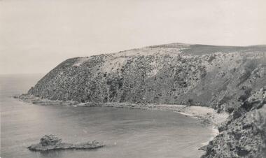
One of a collection of over 400 photographs in an album commenced in 1960 and presented to the Phillip Island & Westernport Historical Society by the Shire of Phillip IslandPhotograph of Cliff Formation east side - Cape Woolamai.local history, photography, photographs, coastline, cape woolamai, phillip island, cliffs, john jenner, bryant west -
 Phillip Island and District Historical Society Inc.
Photograph, Bryant West
One of a collection of over 400 photographs in an album commenced in 1960 and presented to the Phillip Island & Westernport Historical Society by the Shire of Phillip IslandPhotograph of Rocks and Beach south side of Cape Woolamai.local history, photography, photographs, coastline, rocky beach, reef, cape woolamai, phillip island, reefs, john jenner, bryant west -
 Federation University Historical Collection
Costume - Nursing, Nurses uniform and cape, 1970s?
This uniform was worn by student nurses at the Hillcrest Psychiatric Hospital in Adelaide in the early 1970s. In 1964, Northfield Mental Hospital was renamed Hillcrest Hospital. .1) Mid pink waisted and darted uniform with a front pocket (with H H embroidered) on left breast and side pockets on skirt. Buttoned up the front, with three buttons on top and a placket with four hidden buttons on skirt. There is a hook and eye at the waist and a separate belt with two buttons and buttonholes. There is a collar and cuffed short sleeves, a back yoke and a center inverted pleat. .2) A lined (double layer) woollen royal blue cape with collar and neck tie and a hook and eye clasp.Embroidered on top pocket - H Hnursing, hillcrest hospital, student nurse uniform, nurse cape, costume, textiles, cape, uniform, hillcrest psychiatric hospital -
 Glenelg Shire Council Cultural Collection
Artwork, other, Ian Rankin, Low Tide - Cape Grant Area, 1990
Depiction of a beach with large boulders in the foreground. The boulders are covered in lichen and algae, and beach sweeps up towards centre right of image. The central third of painting shows the sea (continuing behind the boulders), depicted in blue with white highlights and dark blue shadows. It is edged in the background by a cliff face (painted in brown and grey). Sky is darker blue at top and lighter blue where it meets the horizon. Mounted in double matt (pale tan on faun) with decorative cut-out border, framed under glass in wooden frame.Front: Rankin '90 (lower right) (white paint) Back: 333 (upper left) (sticker) 1990- (upper left) (pencil). Low tide Cape Grant area September 1990 $350 Pastel Ian Rankin. 46 Hurd St Portland Vic 3305 Phone Portland 231465. Phone 055/231465.cape grant, seascape, beach -
 Otway Districts Historical Society
Functional Object - Cross, anglican, Christopher Webster, empty, Early 1920s
Because there was no Church of England in Lavers Hill, in the early 1920s Christopher Webster made this Otway timber Cross for Anglican services to be held in the Presbyterian Church.Otway timberchristopher webster, presbyterian church, church of england, lavers hill, otway -
 Queenscliffe Maritime Museum
Painting - Water colour painting of the schooner Argosy Lemal, Argosy Lemal, c. 1930's
Arthur V Gregory b.1867, d.1957 worked from studio at 326 Albert Road South Melbourne established by his father G F Gregory in 1852. As Argosy Lemal the ship served as one of the early United States Army communications ships from 1942–1949.Water colour painting in painted gilt frameArgosy Lemal off Cape Otway A.V. Gregorya.v. gregory, water colour, argosy lemal -
 Phillip Island and District Historical Society Inc.
Photographs, Late 19th Century
Five photos of Granite Quarry in operation.Five sepia photographs of the Granite Quarry at Cape Woolamai in operation.granite quarry cape woolamai, noelle rigby -
 Glenelg Shire Council Cultural Collection
Photograph - Photograph - Cape Grant Quarry, Quarry, Cape Grant, 01/11/1956
Port of Portland Authority ArchivesFront: Back- Border ruled around in pencil. Cape Grant Quarry 1/11/56 'View to south east showing excavtor on limestone level, quarry master on 70ft level and box blast result on 40ft level in foreground. Note rock fave obscured by over burden material' - Pencil '5 x 3/4 approx' - pencilport of portland archives -
 Latrobe Regional Gallery
Print, CHEVALIER, Nicholas, Barkers Bluff, Near Cape Schanck, 1860
Chromo lithographVerso: bot. c. label "BARKER'S BLUFF, NEAR CAPE SCHANCK, From an Original Painting BY N. CHEVALIER. Printed by C. TROEDEL, 100 Swanston- St." Inscription bot. c. on border "442 x 560", "CHEVALIER 1860". Insciption l.r. cnr. embossed watermark "CHA TROEDEL,. CHROMO LITHOGRAPHIC ESTABLISHMENT, 100 SWANSTON ST (encircled)" -
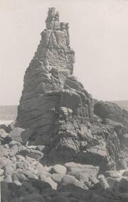
 Phillip Island and District Historical Society Inc.
Photograph, Unknown
One of 6 photographs donated by M. Batty.Black & White photograph of the Pinnacles at Cape WoolamaiOn back: Pinnacles Cape Woolamaithe pinnacles, cape woolamai pinnacles, phillip island coastline, phillip island, m batty -
 Phillip Island and District Historical Society Inc.
Photograph, Bryant West
One of a collection of over 400 photographs in an album commenced in 1960 and presented to the Phillip Island & Westernport Historical Society by the Shire of Phillip IslandPhotograph of Cape Woolamai looking south west across the Eastern Passage.local history, photography, photographs, coastline, eastern channel, phillip island, cape woolamai, john jenner, bryant west -
 Phillip Island and District Historical Society Inc.
Photographs, 1926
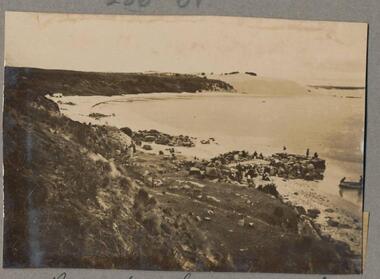
Part of a collection of photographs cut from old photo album with multiple photos per page. Margaret Webster donated the photographs. Margaret's parents were Sir Charles & Lady McGrath who lived near the RSL on Ventnor Road, Phillip Island.286-01 - Sepia photograph of the beach at Cape Woolamai, Phillip Island. 286-02 - Sepia photograph of The Sentinel, Cape Woolamai, Phillip Island. 286-03 - Sepia photograph of The Terrace, Cape Woolamai, Phillip Island. 286-04 - Sepia photograph of Pyramid Rock, Phillip Island. 286-05 - Sepia photograph of the cliffs at Cape Woolamai, Phillip Island.286-01 - "Beach Cape Woolamai Phillip Island" 286-02 - "The Sentinel Cape Woolamai Phillip Island" 286-03 - "The Terrace Cape Woolamai" 286-04 - "Pyramid Rock P.I." 286-05 - "Cliffs - Cape Woolamai"coastline cape woolamai, pyramid rock, the sentinel cape woolamai, the terrace cape woolamai, margaret webster -
 Phillip Island and District Historical Society Inc.
Photograph
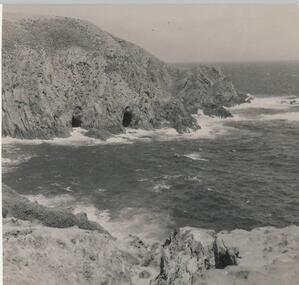
One of a collection of over 400 photographs in an album commenced in 1960 and presented to the Phillip Island & Westernport Historical Society by the Shire of Phillip IslandPhotograph of Caves on the waterline at Cape Woolamai. The caves can only be entered by boat.local history, photography, caves at cape woolamai, black & white photograph, coastline, rock formations, cape woolamai, john jenner, bryant west -
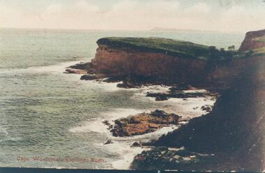 Phillip Island and District Historical Society Inc.
Photograph, 1907
One of a collection of photographs donated by Bruce BennettColoured copy of a postcard showing Cape Woolamai coastline"Cape Woolamai, Victoria, Austr."cape woolamai, coastline cape woolamai, bruce bennett -
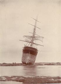 Phillip Island and District Historical Society Inc.
Photograph, 1901
One of a collection of over 400 photographs in an album commenced in 1960 and presented to the Phillip Island & Westernport Historical Society by the Shire of Phillip IslandPhotograph stern view of the Barque "Artisan" high and dry on the rocks at Cape Paterson. 1901.local history, photography, photographs, wrecks, sailing ship "artisan" wrecked at cape paterson, sepia photograph, shipping, ship wrecks, artisan, cape paterson, john jenner, bryant west -
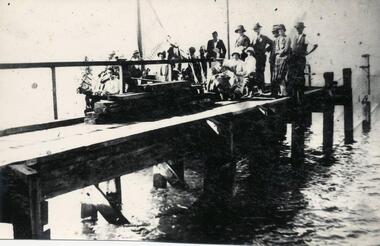 Phillip Island and District Historical Society Inc.
Photograph
One of a collection of over 400 photographs in an album commenced in 1960 and presented to the Phillip Island & Westernport Historical Society by the Shire of Phillip IslandPhotograph of W. J. Kennon's Jetty at Cape Woolamai taken during the Opening Ceremony.local history, photography, cape woolamai jetty, black & white photograph, jetties, cape woolamai, granite quarries, w j kennon, coastline, john jenner, bryant west -
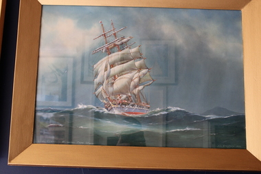 Queenscliffe Maritime Museum
Painting - Water colour painting of the Loch garry, Loch Garry, 1933
Arthur V Gregory b.1867, d.1957 worked from studio at 326 Albert Road South Melbourne established by his father G F Gregory in 1852In her latter years she was still making good passages under Captain Horne, in spite of a shortage of good crews. The following runs are recorded: 1892 Tuskar to Cape Otway 71 days 1894 Downs to Melbourne 77 1895 Lizard to Melbourne 77 1895 Melbourne to Prawle Point 80 1900 Melbourne to Prawle Point 85 1901 Adelaide to Cape Otway 48hr 1903 Port Phillip Heads to Lizard 74 days 1904 Melbourne to Dover 77 1905 Tuskar to Cape Borda 73 1905 Equator to Leeuin 36Water colour painting in painted gilt frameLoch Garry rounding Cape Otway A.V. Gregory 1933a.v gregory, loch garry, water colour -
Federation University Historical Collection
Book, John Slorach, From Timber to Tourism: Exploring Place Attachment and Natural Area Values in the Otway Ranges, 05/01/2007
Black hard covered book prepared for the BS801 Honours Research Dissertation, Bachelor of Business (Tourism) (Honours)university of ballarat, school of business, john slorach, mary hollick, tourism, timber, otway ranges, timber harvesting, forestry, environment