Showing 750 items matching "chart"
-
 Hand Tool Preservation Association of Australia Inc
Chasers
This item is part of the Thomas Caine Tool Collection, owned by The National Trust of Australia (Victoria) and curated by the Hand Tools Preservation Association of Australia.Chasers for thread selection chart -
 The Celtic Club
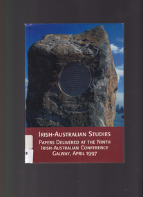
Book, Tadhg Foley, Irish-Australian Studies: Papers delivered at the ninth Irish-Australian converence, Galway, April 1997, 2000
Papers of the ninth Irish Australian Conference held at Galway in1997Charts, ill, p.307.non-fictionPapers of the ninth Irish Australian Conference held at Galway in1997academic conferences - ireland, irish australian history -
Whitehorse Historical Society Inc.
Map, Yarran Dheran Charts, 1974
Charts relating to the formation of Yarran DheranRolled charts of various dimensionsnon-fictionCharts relating to the formation of Yarran Dheranyarran dheran, yarran dheran advisory committee, thompson paul -
 Victorian Aboriginal Corporation for Languages
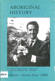
Periodical, Australian National University Department of Pacific and Southeast Asian History, Aboriginal history, 2000
maps, charts, b&w photographs -
Victorian Aboriginal Corporation for Languages
Book, Pat Dodson et al, Recognising Aboriginal and Torres Strait Islander Peoples in the Constitution : report of the expert panel, 2012
Current multiparty support has created a historic opportunity to recognise Aboriginal and Torres Strait Islander peoples as the first peoples of Australia, to affirm their full and equal citizenship, and to remove the last vestiges of racial discrimination from the Constitution. The Expert Panel was tasked to report to the Government on possible options for constitutional change to give effect to Indigenous constitutional recognition, including advice as to the level of support from Indigenous people and the broader community for these options. This executive summary sets out the Panel's conclusions and recommendations" [taken from executive summary]. Report contains draft Bill for an Act to alter the Constitution to recognise Aboriginal and Torres Strait Islander peoples and their cultures, languages and heritage, to replace racially discriminatory provisions and to include a prohibition of racial discrimination. Letter to the Prime Minister Foreword from the co-chairs Executive summary Introduction: Expert panel and its methodology 1. Historical background 2. Comparative and international recognition 3. The national conversation: themes from the consultation program 4. Forms of recognition 5. The 'race' provisions 6. Racial non-discrimination 7. Governance and political participation 8. Agreement-making 9. The question of sovereignty 10. Approaches to the referendum 11. Draft bill Appendixes Bibliography.maps, tables, colour photographs, chartsconstitutional history, legislation, australian constitution, constitutional law, closing the gap, 1967 referendum, white australia policy, sovereignty -
Victorian Aboriginal Corporation for Languages
Book, Peter Cabena et al, The lands manual : a finding guide to Victorian lands records 1836-1983, 1992
charts, extracts from original documentsvictorian history, archives, local history, crown lands, public lands, land tenure -
 Federation University Historical Collection
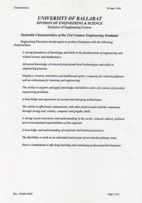
Document - Document - Student Characteristics, VIOSH: University of Ballarat, Division of Engineering and Science, Desirable Characteristics of Graduates
Victorian Institute of Occupational Safety and Health (VIOSH) Australia is the Asia-Pacific centre for teaching and research in occupational health and safety (OHS) and is known as one of Australia's leaders on the field. VIOSH has a global reputation for its innovative approach within the field of OHS management. VIOSH had its first intake of students in 1979. At that time the Institution was known as the Ballarat College of Advanced Education. In 1990 it became known as Ballarat University College, then in 1994 as University of Ballarat. It was 2014 that it became Federation University. VIOSH Australia students are safety managers, senior advisors and experienced OHS professionals. They come from all over Australia and industry. Students are taught active research and enquiry; rather than textbook learning and a one-size fits all approach. VIOSH accepts people into the Graduate Diploma of Occupational Hazard Management who have no undergraduate degree - on the basis of extensive work experience and knowledge. A document titled "Desirable Characteristics of the 21st Century Engineering Graduate" was from the University of Ballarat Division of Engineering and Science, Bachelor of Engineering Course. Page 1 states that Engineering educators should aspire to produce Graduates with a defined set of characteristics - 10 listed. Page 2 relates to the Engineering Course stating it should emphasise a number of key areas - 8 listed. Examples were obtained from Wollongong and Monash. These ideas were then used to formulate 10 characteristics for the University of Ballarat - "The Ideal Science Graduate" Document tabled by Roy Schrieke "The Ideal Science Graduate" 14/03/1995Six A4 pages - typed and with chartsviosh, victorian institute of occupational safety and health, university of ballarat, desirable charcteristics of engineering students, roy schrieke - lecturer, wollongong, monash, engineering and science -
 Federation University Historical Collection
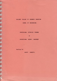
Manual - Manual - Readings, VIOSH: Manual of Readings for Professional Extension Program in Occupational Hazard Management
Manual of readings for various essay topics.Spiral bound manual - charts and graphsviosh, victorian institute of occupational safety and health, occupational hazard management, essay topic readings -
 Greensborough Historical Society
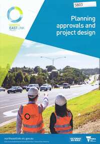
Pamphlet, Victorian Government, Planning approvals and project design: North East Link Project, 2018_09
Describes the use of an environment effects statement (EES) in the planning approval and project design process for the North East Link. 6 p., col. photographs and chartsnorth east link -
 Running Rabbits Military Museum operated by the Upwey Belgrave RSL Sub Branch
Photo
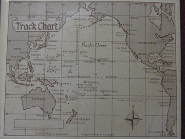
Track Chart, Pacific Ops. Areaphoto, ww2, ran -
University of Melbourne, Burnley Campus Archives
Document, Burnley Weather Records, 1951-1980
Rainfall charts, observations, notes, correspondencerainfall charts, observations, burnley, weather records -
 Clunes Museum
Photograph
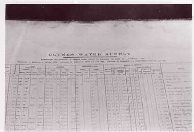
PHOTOGRAPH - CHART - CLUNES WATER SUPPLYlocal history, photography, photograph, water supply -
 Ringwood and District Historical Society
Document - Family Tree, Family tree of Philip Bamford in 2000, Feb-00
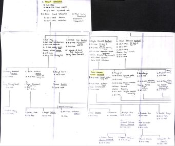
Family tree of Philip Bamford. Chart -
 Victorian Aboriginal Corporation for Languages
Book, Somesh Kumar, Methods for community participation : a complete guide for practitioners, 2002
A manual for participatory development.maps, b&w illustrations, tables, chartscommunity development, rural development -
 Victorian Aboriginal Corporation for Languages
Book, Finding families : the guide to the National Archives of Australia for genealogists, 1998
The focus of this publication is on the range of records of most value to genealogists, those in which essential details of former lives are held. Exploring official records reveals the facts of these lives: of where and when and how men and women served their nation in wartime; or settled in a new country; or were employed on public projects; or were educated or assisted through Commonwealth government agencies.b&w photographs, copies of records, chartsgenealogy, local history, national archives of australia -
 Victorian Aboriginal Corporation for Languages
Book, Tasmania State Emergency Service, Map reading handbook, 1997
maps, b&w photographs, charts, diagramsmaps reading, aerial photographic maps, global positioning systems, topographical maps, compasses -
 Federation University Historical Collection
Booklet - Booklet - Case Study, VIOSH: Booklet: The South Australian Brewing Co Ltd, Case Study, 1983
A Case Study of Occupational Safety in South Australian Brewing Co Ltd by Brian Vasey and Charles ConnellyThirty-eight page booklet with charts and diagramsviosh, victorian institute of occupational safety and health, south australian brewing co ltd, case study, brian vasey, charles connelly -
 Flagstaff Hill Maritime Museum and Village
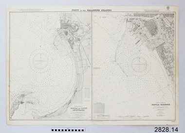
Document - Navigation Chart, Manila Harbour
British Admiralty Navigation Chart - Manila Harbourwarrnambool, shipwrecked-coast, flagstaff-hill, flagstaff-hill-maritime-museum, maritime-museum, shipwreck-coast, flagstaff-hill-maritime-village, shipwrecked-artefact, navigation chart, british admiralty navigation chart, manila harbour -
 Flagstaff Hill Maritime Museum and Village
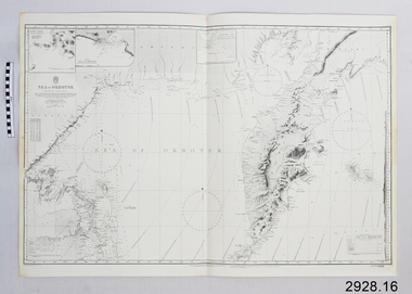
Document - Navigation Chart, Sea of Okhotsk
British Admiralty Navigation Chart - Sea of Okhotskwarrnambool, shipwrecked-coast, flagstaff-hill, flagstaff-hill-maritime-museum, maritime-museum, shipwreck-coast, flagstaff-hill-maritime-village, shipwrecked-artefact, navigation chart, british admiralty navigation chart -
 Flagstaff Hill Maritime Museum and Village
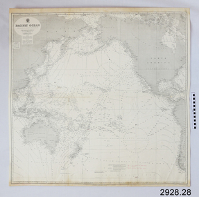
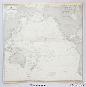
Document - Navigation Chart, Pacific Ocean
British Admiralty Navigation Chart - Pacific Oceanwarrnambool, shipwrecked-coast, flagstaff-hill, flagstaff-hill-maritime-museum, shipwreck-coast, maritime-museum, flagstaff-hill-maritime-village, shipwrecked-artefact, navigation chart, british admiralty navigation chart, british admiralty, pacific ocean -
 Flagstaff Hill Maritime Museum and Village
Document - Navigation Chart, Pacific Ocean
British Admiralty Navigation Chart - Pacific Oceanwarrnambool, shipwrecked-coast, flagstaff-hill, flagstaff-hill-maritime-museum, maritime-museum, shipwreck-coast, flagstaff-hill-maritime-village, shipwrecked-artefact, navigation chart, british admiralty navigation chart, british admiralty, pacific ocean -
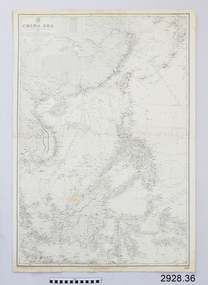 Flagstaff Hill Maritime Museum and Village
Document - Navigation Chart, China Sea
British Admiralty Navigation Chart - China Seawarrnambool, shipwrecked-coast, flagstaff-hill, flagstaff-hill-maritime-museum, maritime-museum, shipwreck-coast, flagstaff-hill-maritime-village, shipwrecked-artefact, navigation chart, british admiralty navigation chart, british admiralty, china sea -
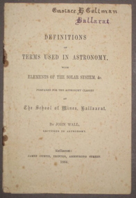 Federation University Historical Collection
Booklet, John Wall, Definitions of Terms used in Astronomy with Elements of the Solar System, 1884, 1884
Ballarat School of Mines lecturer, John Wall, prepared this book for the Astronomy class of the Ballarat School of Mines12 page printed booklet with additional charts. Front cover "Eustace H. Coltman Ballarat'ballarat school of mines, astronomy, john wall, eustace coltman, solar system -
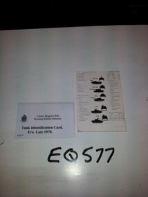 Running Rabbits Military Museum operated by the Upwey Belgrave RSL Sub Branch
Chart Tank Recognition
Chart Tank recognition RAAC Commanders Cardequipment, 1st gulf war, army -
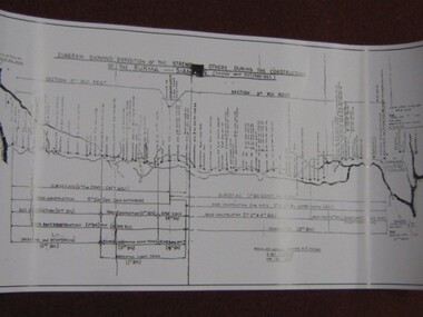 Running Rabbits Military Museum operated by the Upwey Belgrave RSL Sub Branch
Photo
Chart of camps along the Burma-Siamese Railwayphoto, ww2, army -
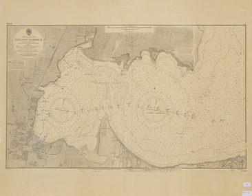 Queenscliffe Maritime Museum
Map - Chart of Geelong Harbour, Geelong Harbour
When Hamilton Hume and William Hovell arrived at the bay in 1824 they met with the local Wautharong people who referred to the bay as "Jillong" and the surround land "Corayo", but by the time the area was surveyed in the late 1830s the Aboriginal names had been swapped. The names "Corayo" and "Jillong" had since been Anglicised to "Corio" and "Geelong".Corio Bay is an important harbour and leisure location in the West and continues to attract development such as the new Tasmania Ferry Terminal.An Admiralty Chart of Geelong Harbour revised in 1954Geelong Harbour Map Ref: 2731geelong, corio, admiralty charts -
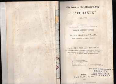 Mrs Aeneas Gunn Memorial Library
Book, McMillan and Co et al, The cruise of Her Majesty's ship Bacchante, 1879-1882 v.1, 1886
A description of a world cruise taken by Prince Albert Victor and Prince George of Wales.Ill, charts, maps, plans, p.675.non-fictionA description of a world cruise taken by Prince Albert Victor and Prince George of Wales.australia - description and travel, voyages around the world -
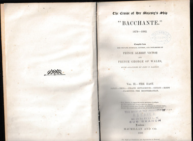 Mrs Aeneas Gunn Memorial Library
Book, McMillan and Co et al, The cruise of Her Majesty's ship Bacchante, 1879-1882 v.2, 1886
A description of a world cruise taken by Prince Albert Victor and Prince George of Wales.Ill, charts, maps, plans, p.803.non-fictionA description of a world cruise taken by Prince Albert Victor and Prince George of Wales.australia - description and travel, voyages around the world -
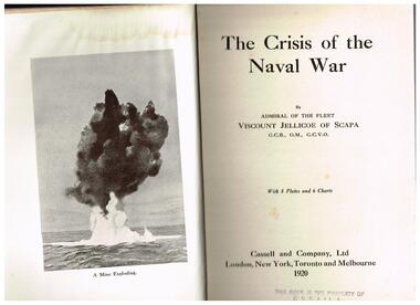 Mrs Aeneas Gunn Memorial Library
Book, Admiral of the Fleet, Viscount Jellicoe of Scapa, The crisis of the naval war, 1920
British naval operations in the Great WarIndex, i,ll, charts. p.331.non-fictionBritish naval operations in the Great Warworld war 1914-1918 - naval operations, royal navy - operations -
 Camberwell Historical Society
Booklet (Item), Robert Ewins, Alamein Community Committee Inc.: A Short History (from its origins in 1976 to 1993), 1994
camberwell, alamein