Showing 2060 items
matching crossing
-
 Kiewa Valley Historical Society
Book - Kiewa River, Stocking and Crossing the Kiewa River by Jan Hunter (nee Chick), 2020
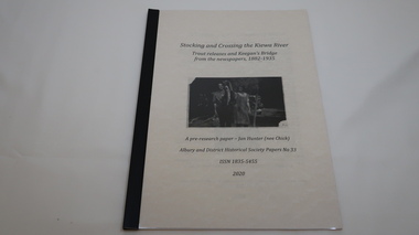
The Chick brothers, Alf, Les and Allan, plus friends, began trout fishing and camping in the Kiewa Valley before the early 1930s. Les continued his connection with the Kiewa River until his death in 1972. Fingerlings were placed in the Kiewa River from the early 1880s. Keegan's Bridge is a crossing near Upper Gundowring and about 4 km south east of Dederang. References to the crossing were made in the early 1900s and a petition presented to Council in 1904 calling for a bridge.The bridge was built and opened in 1907. The photos are of the release of fingerling trout in the Kiewa River, thought to be at Keegan's Bridge. The fingerlings were transported in drums on the back of trucks. The photos are c1940s.The Kiewa Valley has been a popular spot for fishermen, tourists and campers from the 1880s. One of the many attractions has been the excellent fishing along the Kiewa River due to the regular release of fish especially brown trout. This continues to the present day (2020) when a few fish were marked with $$ signs for the lucky fisherman who caught them. This attracts visitors, their families and boosts the economy and dates back to visits at the Tawonga Pub prior to the Kiewa Hydro Electric Scheme.19 page book with black plastic spine and clear plastic cover over the beige paper cover with title , author and black & white photo. Note: In KVHS photo collection there are 4 good quality reproduction photos on photographic paper. These have been produced professionally. These photos of Jan Hunter's are featured on the second page of her book. These also have a letter attached. The book is a pre-research paper & is No 33 of the Albury and District Historical Society Papers. The sub-title is "Trout releases and Keegan's Bridge / from the newpapers, 1882-1935"None on the book but a letter is attached from Jan Hunter, the author as a follow up to the photos she donated. On the photos - On the back: Fujifilm / Fujicolor Crystal Archive / Paper / Production - run codekiewa river; trout; fish; keegan's crossing; keegan's bridge; fingerlings; chick family; camping; tourism -
 Greensborough Historical Society
Photograph - Digital Image, Marilyn Smith, Plenty River at the aqueduct crossing Greensborough 2019, 02/07/2019
The Plenty River at the aqueduct crossing, 2019, showing graffiti on the river bank rocks. Originally part of the Maroondah Aqueduct pipeline, all that remains is the bridge that once carried the pipe over the Plenty River. This photograph was taken from the Plenty River Trail in Greensborough. 2 colour digital photographsplenty river trail, maroondah pipetrack, maroondah aqueduct, plenty river, graffiti -
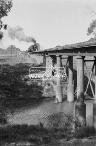
 Ballarat Tramway Museum
Photograph - Black & White Photograph/s, Lydidard St level crossing and a picnic train, c1905 to 1906
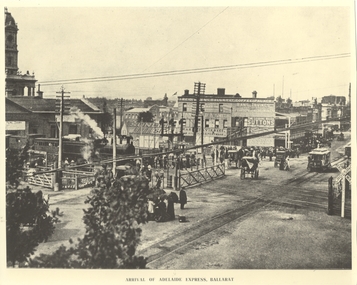
Yields information about the Lydiard St level crossing.Black and white photograph of No. ESCo No. 10 about to cross the Lydiard St level crossing. Photo has the title of "Arrival of Adelaide Express, Ballarat", which is not correct for the trains consist - more like a picnic special - this photo has been written up somewhere. D class loco, with two six wheel carriages behind the locomotive. Group of women with umbrellas (sun) waiting for the tram. Horse drawn carts, interlocked gates, signals prior to resignalling of the post and railway level crossing signs. In the background is Reids Coffee Palace, advertising Sunlight soap, Suttons Music, Pearson's Hard soap, Hans Irvines Champion Wines and Standard & Smith.trams, tramways, railway station, lydiard st north, reids coffee palace, esco, tram 10 -
 Ballarat Tramway Museum
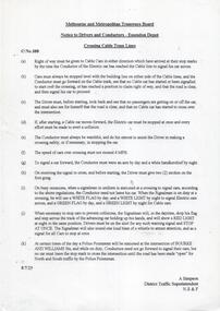
Slide - 27 mm sq slide/s, Andrew Howlett, Trams crossing at Barrett Ave or Depot Loop, Feb 1969?
Yields information about Wendouree Parade at the depot loop and the Begonia Festival tram of 1969 and a special tram service.Colour slide, Kodak white cardboard mount, developed Mar 1969 of No. 26 eastbound crossing Begonia Festival Showboat tram No. 21 at the Barrett Ave or Depot Loop. No. 26 is running a Special. One of a series of tour photos - see Reg item 7667, 7668, 7683 and 7701.ballarat, tramways, trams, wendouree parade, decorated trams, begonia festival, depot loop, barrett ave, tram 26, tram 21 -
 National Vietnam Veterans Museum (NVVM)
Photograph, Gibbons, Denis, Crossing the Line 4
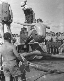
Denis Gibbons (1937 – 2011) Trained with the Australian Army, before travelling to Vietnam in January 1966, Denis stayed with the 1st Australian Task Force in Nui Dat working as a photographer. For almost five years Gibbons toured with nine Australian infantry battalions, posting compelling war images from within many combat zones before being flown out in late November 1970 after sustaining injuries. The images held within the National Vietnam Veterans Museum make up the Gibbons Collection. A black and white photograph of diggers from 9th Battalion, Royal Australian Regiment. After being 'found guilty' one is cast into the sea by courtiers of King Neptune during the 'crossing of the line' ceremony on board the Vung Tau Ferry HMAS Sydney, taking the Battalion to war service in Vietnam.photograph, hmas sydney, vung tau ferry, 9th battalion, royal australian regiment, crossing the line, denis gibbons, photographer, vietnam war, diggers -
 Ballarat Tramway Museum
Photograph - Black & White Photograph/s, Bendigo 18 crossing Charing Cross, late 1950's
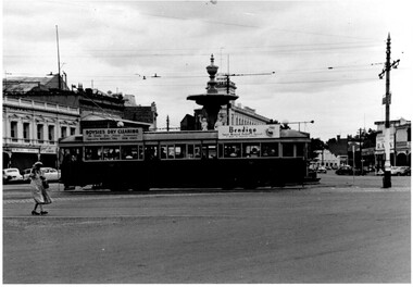
Black and White photograph, of Bendigo 18 crossing Charing Cross en route to Eaglehawk. Has roof ads for Boysies Dry Cleaning and Bendigo Sweet Mustard, Pickles spread. In the background is the fountain, Club Hotel, RACV and Neilors Wines Hotel? Printed on Fujicolour paper. Two copies held. "TMSV Sales" stamp on rear. On rear of in ink "PM & MM E45 = Bend 18" trams, tramways, bendigo, charing cross, tram 18 -
 Ballarat Tramway Museum
Slide - 27 mm sq slide/s, Andrew Howlett, Tram No. 37 (Special) crossing Sturt St at the Dawson St crossover, Feb or March 1969
Yields information about the Dawson St cross over in Sturt St and St Patricks church.Colour slide, Kodak white cardboard mount, developed Mar 1969 of No. 37 (Special) crossing Sturt St at the Dawson St cross over. St Patricks church in the background. St Patricks church in the background. See Reg Items 7675, 7678, 7681, 7684, 7686, 7705 and 7713. "Dawson St X over" in red inkballarat, tramways, trams, sturt st, tours, dawson st, tram 37 -
 Melbourne Tram Museum
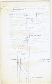
Document - Research Notes, H. S. McComb, cable tram crossing with the Northcote Brick Company - part 2, 1937
Nine foolscap sheets, 7 pinned together - track layout and general notes on the Northcote Cable tramway showing track layouts, depot location, railway crossings, Queens Parade, Dundas St. Items 2053 to 2057 within box 72.3 in a brown folder marked "Northcote CC" in red pencil.trams, tramways, northcote, cable trams, railways, queens parade, dundas st -
 Melbourne Tram Museum
Drawing, Jack Cranston, "The cable tram crossing"
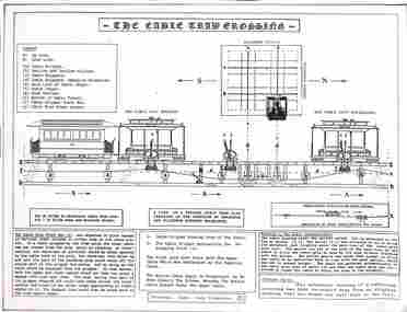
The drawing shows the arrangement of the cables and associated equipment where two lines crossed each other at right angles. Details the cable grip check bar to release the cable from the grip, and how the cable was picked up automatically after crossing the other cable. Prepared by Jack Cranston.Yields information about the cable arrangements at points where two lines crossed each other.Card sheet with a printed sheet adhered to it.tramways, cable trams, cables, h crossing -
 Ballarat Tramway Museum
Slide - 35mm slide/s, Keith Caldwell, Tram 42 crossing Doveton St, 8/03/1960
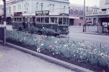
Photo by Keith Caldwell on 8/3/1960 of tram 42 inbound in Sturt St crossing Doveton St. Has the central median planted with many flowers, In the background is Heinz Bros store. The tram has the destination of Lydiard St north and has roof adverts for Penfolds Sherry and Briquettes.Yields information about the tram 42 and the intersection with Doveton St.Agfa colour slide, white cardboard mount. Stamped on bottom of slide "8 Mar 60". tramways, trams, sturt st, doveton st, tram 42 -
 Ballarat Tramway Museum
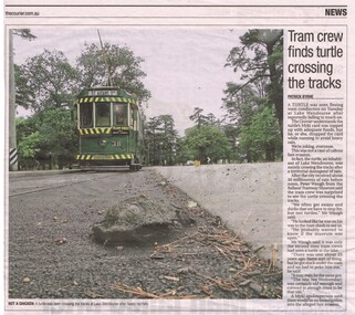
Newspaper, The Courier Ballarat, "Tram crew finds turtle crossing the tracks", 15/01/2015 12:00:00 AM
Newspaper clipping from The Courier, 15/1/2015, titled "Tram crew finds turtle crossing the tracks". Has a photo of tram 38, northbound near depot junction with the turtle, actually a tortoise, in the foreground. It was a slow news day in Ballarat! Quotes Peter Waugh, and has the story around a Myki card.btm, wendouree parade, turtle, tortoise, animals -
 Ballarat Tramway Museum
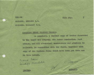
Document - Letter/s, State Electricity Commission of Victoria (SECV), "Crossing Under Tramway Tracks", May. 1937
Yields information about the correspondence that was sent from Ballarat from Geelong about underground services under tram tracks.Carbon copy of a letter on demi foolscap green paper (1 sheet) dated 24/5/1937 from the Ballarat SEC Manager to the Managers ES of Geelong and a copy to the Ballarat ES, forwarding correspondence regarding installation of services under tram tracks. Titled "Crossing Under Tramway Tracks", notes who received the documents locally.Has various initials and a note in ink "copied now Bendigo procedure"trams, tramways, letters, sec, tram track, geelong -
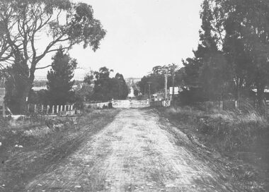 Ringwood and District Historical Society
Photograph, Heatherdale Road rail crossing looking south c1924
2 Black and White Photographs mounted on backing sheetsTyped below photograph and on rear of backing sheets - "Heatherdale Road rail crossing looking south c1924. Sign advertises Heatherdale Rd. Estate, 304 blocks for sale at £50 each, £5 deposit and 1/- per week. Miss Condon was the gatekeeper. -
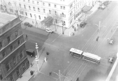 Melbourne Tram Museum
Photograph, Menzies Hotel and the Goldsborough & Mort Woolstore with a cable tram crossing William Street in Bourke Street, c1937
The photograph shows a cable tram in Bourke St, crossing over the electric tram track in William Street. The Menzies Hotel 1867 (see reference) is in the background, along with the Goldborough Mort Woolstore building 1862 on the opposite corner. Also in the photo are the Melbourne Centenary "Lollypop" street decorations of 1934. The photo appears to be taken from the roof of the Shell Building in William Street. Yields information about the Menzies Hotel and the intersection of Bourke and William St. Photograph, black and white, plain papertrams, tramways, cable tram, bourke st, william st, menzies hotel, goldsborough mort, melbourne centenary -
 Ballarat Tramway Museum
Slide - 27 mm sq slide/s - set of 2, Andrew Howlett, No. 34 and 37 crossing at the Duncan St loop in Drummond St North, Mar. 1969
Yields information about the Drummond St line and the Mills St loop area and a special tram tour using No. 37.Colour slide, Kodak white cardboard mount, developed Mar 1969 of No. 34 and 37 crossing at the Duncan St loop in Drummond St North. No. 34 has destination of Gardens via Drummond North, while No. 37 running a special service. .2 - No. 37 in the loop by itself. See Reg Items 7675, 7678, 7681, 7684, 7686, 7705 and 7713."Duncan St Loop Drummond St" in red ink.ballarat, tramways, trams, drummond st nth, mill st loop, tram 34, tram 37 -
 Ballarat Tramway Museum
Negative, Wal Jack, Geelong 21 and 22 crossing at the Albert St loop in Pakington St, 23/6/1949
Geelong 21 and 22 crossing at the Albert St loop, the second loop in Pakington St. Tram 21 has the destination of Station, and 22 the destination of West. See item 9053 for details of the location and date - 23-6-1949. Refer to "Twenty five years ago, the Closure of the Geelong Tramways", by Ken McCarthy, April 1981 issue of Trolley Wire page 10 for routing information. Yields information about tram operations in Pakington St.Negative and Digital images of the Wal Jack Geelong Negative file.trams, tramways, geelong, pakington st, west, station, tram 21 tram 22 -
 Yarra Glen & District Historical Society
Black and white photographs, Yarra Glen railway crossing c.1900
Black and white photograph in light brown card slip case. The slip case has an image on the front cover of a head and shoulder bust. The photograph was taken about 1900 from the tower of the Grand Hotel looking down upon the Victoria Hall and the railway crossing. In the lower left corner is W.J.Dawborn's General Store. In front of the store is a horse and spring dray and another horse hitched to a veranda post. Next to the store is the Victoria Hall and beyond that a water trough. The railway crossing is in the centre of the picture with two railway cattle trucks next to the cattle yards. Beyond the railway on the left hand side is the property later known as 'River View'. Beyond the river lined with trees are the Yering flats across which can be seen the long trestle railway bridge. In the foreground of the picture is Bell Street lined with trees in wooden tree guards.yarra glen, victoria hall, railway crossing, river view, general store, w j dawborn, horse and cart, horse and dray, spring dray, horse hitched, hitching post, water trough, railway truck, cattle truck, cattle yards, stock yards, yering flats, trestle railway bridge, trestle bridge -
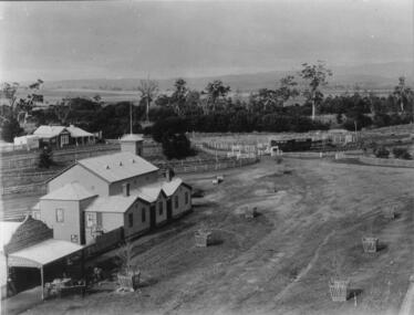
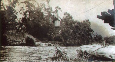 Kiewa Valley Historical Society
Photo - Tawonga Bridge.( Set of 2 photos)
Photo 1 - Rene Roper (Postmistress) crossing swollen Kiewa River on a milk can flying fox at Tawonga, during high winter waters Photo 2 - First Tawonga bridge was built in 1884- destroyed by floods in 1916. New bridge constructed 1923 and destroyed in 1953. Present concrete bridge constructed in 1986 and named Ryders BridgeBridge construction over Kiewa River at TawongaCopies of two original black and white photos. Photo 1 - Flying fox at site of Tawonga Bridge over the Kiewa River Photo 2 - Timber pile bridge over the Kiewa River at Tawongatawonga bridge, kiewa valley -
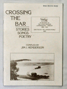 Orbost & District Historical Society
Book, Crossing The Bar, 1993
Jim Henderson has written several books about the Wareiwa and Hospital Creek area.This is a useful reference item.A 40 pp book titled Crossing The Bar , Stories,Songs, Poetry. On the front cover is an early photograph of two coaches and horses on the sand bar at Lakes Entrance at the Gippsland Lakes. In the top right corner is a photograph of part of the memorial plaque erected by the Jonson family of Tostaree in 1993. " In memory of the coach drivers Cunninghame-Orbost 1886-1916." The book was compiled by Jim I. Henderson.Jim Henderson 31/10/1993wairewa nowa-nowa hospital-creek waygara transport-history-east-gippsland -
 Ballarat Tramway Museum
Slide - 27 mm sq slide/s, Andrew Howlett, trams 37 and 34 crossing at the Grant St Loop, Mar. 1969
Yields information about the services on the Mt Pleasant line and tram tours.Colour slides, Kodak white cardboard mount, developed Mar 1969 of trams 37 and 34 crossing at the Grant St Loop. No. 37 showing special, while No. 34 has destination of Gardens via Drummond North and is carrying an auxiliary sign "Trotting Bray Raceway Friday night". Barkly St, Mt Pleasant. See Reg Items 7675, 7678, 7681, 7684, 7686, 7705 and 7713.ballarat, tramways, trams, barkly st, mt pleasant, grant st, tram 37, tram 34 -
 Melbourne Tram Museum
Document - Instruction, Melbourne & Metropolitan Tramways Board (MMTB), "MMTB Notice to Drivers and Conductors - Essendon Depot - Crossing Cable Tram Lines", c1995
Retyped Instruction - MMTB - C No. 388, signed by A. Simpson District Traffic Superintendent, NS&F, dated 8/7/1925, giving instructions for trams crossing William St lines and in particular Bourke and William St. Notes the duties of the Conductors, drivers, flagmen and policemen. Two copies held - one on a single sheet and one copy on two sheets of paper. Would appear to have been retyped from the original document.trams, tramways, cable trams, essendon depot, william st, instructions, flagmen, bourke st, conductors, signalmen -
 Ballarat Tramway Museum
Slide - 27 mm sq slide/s, Andrew Howlett, Nos. 34 and 26 crossing at the Parked St loop in Sturt St west loop, Mar. 1969
Yields information about the Sturt St West Parker St Loop.Colour slide, Kodak white cardboard mount, developed March 1969 of Nos. 34 and 26 crossing at the Parked St loop in Sturt St west loop. No. 34 is heading for Mt Pleasant and has a Trotting at Bray Raceway auxiliary board and No. 26 running a Special. Shows how's the motor vehicle traffic had to veer out past trams. One of a series of tour photos - see Reg item 7667, 7668, 7683 and 7701.Has in red ink "Sturt St Loop"ballarat, tramways, trams, sturt st west, parker st loop, tram 26, tram 34 -
![The Old Crossing-Place at Fernshawe / [by] Nicholas Caire, circa 1876](/media/collectors/550653872162f11fb04854aa/items/577b49a5d0cdd10948c74db4/item-media/577b4a0bd0cdd10948c78ebb/item-fit-380x285.jpg) Kew Historical Society Inc
Kew Historical Society IncPhotograph, Anglo-Australasian Photographic Company, The Old Crossing-Place at Fernshawe, c. 1876
Nicholas Caire was born on Guernsey in the Channel Islands in 1837. He arrived in Adelaide with his parents in about 1860. In 1867, following photographic journeys in Gippsland, he opened a studio in Adelaide. From 1870 to 1876 he lived and worked in Talbot in Central Victoria. In 1876 he purchased T. F. Chuck's studios in the Royal Arcade Melbourne. In 1885, following the introduction of dry plate photography, he began a series of landscape series, which were commercially successful. As a photographer, he travelled extensively through Victoria, photographing places few of his contemporaries had previously seen. He died in 1918. Reference: Jack Cato, 'Caire, Nicholas John (1837–1918)', Australian Dictionary of Biography.An original, rare photograph from the series 'Views of Victoria: General Series' by the photographer, Nicholas Caire (1837-1918). The series of 60 photographs that comprise the series was issued c. 1876 and reinforced a neo-Romantic view of the Australian landscape to which a growing nationalist movement would respond. Nicholas Caire was active as a photographer in Australia from 1858 until his death in 1918. His vision of the Australian bush and pioneer life had a counterpart in the works of Henry Lawson and other nationalist poets, authors and painters.Albumen silver photograph mounted on boardInscription on reverse: ‘In the distance among the foliage can be seen the New Bridge across the River Watt. Previous to its erection, the only means of crossing over to the township was across the fallen trees, which are of prodigious dimensions. The River, as may be seen, is very rapid, and, though shallow, it contains a great quantity of fish of a somewhat moderate size.’nicholas caire (1837-1918), landscape photography -
 Eltham District Historical Society Inc
Postcard - Photograph postcard, Old Bridge, Kaylock's Crossing, Brougham Street, Eltham, c.1912
Date estimated to be circa 1912 based on the style of printing on the reverse of the card - Kodak Austral paper for real photo postcards, the paper was manufactured c.1908-1914 (See also POSTCARDS ON KODAK PAPER - IS IT POSSIBLE TO "DATE" THEM? http://tps.org.au/bb/viewtopic.php?t=115) Brougham Street was created in Josiah Holloway's 1851 subdivision of Little Eltham. It was one of several east-west streets shown on the subdivision plan as crossing the Diamond Creek. The western part was named Wellington Street on the subdivision plan but was later changed to conform with the name of the eastern part as acknowledgement of the continuity of the street. It is not known when the first bridge was constructed in Brougham Street however it was certainly mentioned at Council’s meeting of 2 June 1884 as being in a dangerous state of repair. This photo (c.1895) of an old bridge shows a very low-level simple log girder bridge crossing the creek at a right angle and so the approaches involved bends in the road alignment. This bridge was generally known as Kaylocks Bridge or Kaylock’s Crossing after the owner of the adjoining land. It was most likely built from around the mid-1850s, or a crossing of some fashion established as Richard George Kaylock, butcher of Little Eltham and his wife Emily Ann settled there in 1854. His property was in Wellington Street (now Brougham Street) and apparently extended across the Diamond Creek. The land on the western side of the creek was farmed, the house being on the eastern side. Kaylock's Bridge formed part of the original coach road to Eltham and in 1922 was described as an "old rustic bridge". Its low level and insubstantial construction made it susceptible to flood damage, necessitating frequent closures until repairs could be carried out. In September 1922, Council called for tenders for a new timber bridge to be constructed at Kaylock’s crossing. An engineering assessment carried out for the Council by Macleod Consulting at the time of the replacement suggested that the construction details indicate that it was in the 1900s, however this dating could possibly have been the result of numerous repairs undertaken over the years to flood damage. The tender was awarded to Mr Weller of Kangaroo Ground who commenced work in February 1923 on a higher-level timber trestle bridge. Work was slowed due to illness of the contractor and the accidental death of a man in March 1923 following the collapse of the bank after he had jumped into a hole that had just been blasted. The bridge was completed around July 1923 at which point the old structure was pulled up, marking what was described in the ‘Advertiser’ newspaper as the passing of an old and well-loved landmark in the district. In April 1924 the approach to Kaylocks bridge was washed away during the heavy flooding that destroyed the Main Road bridge. The western side was repaired, and an extra span was added to the eastern side using timber from the destroyed Main Road bridge. The bridge was again severely damaged four months later in August 1924 When a lack of finances delayed repairs to the Bridge Street bridge in 1931 (also referred to as Obelisk Bridge at the time), traffic had to detour via Brougham Street for some time. Local residents feared that the Bridge Street bridge might never reopen. Kaylocks Bridge was constantly subject to damage by floods. In the 1934 flood it was submerged by two feet of water. In more recent times the bridge was again severely damaged by flooding and repairs made. A new bridge and adjoining footbridge were constructed in 2009.Digital file only Postcards scanned from the collection of Michael Aitken on loan to EDHS, 2 Sep. 2022michael aitken collection, eltham, postcards, bridge, brougham street, diamond creek (creek), kaylocks bridge, wellington street -
 Eltham District Historical Society Inc
Photograph, Old Bridge, Kaylock's Crossing, Brougham Street, Eltham, c.1895
Brougham Street was created in Josiah Holloway's 1851 subdivision of Little Eltham. It was one of several east-west streets shown on the subdivision plan as crossing the Diamond Creek. The western part was named Wellington Street on the subdivision plan but was later changed to conform with the name of the eastern part as acknowledgement of the continuity of the street. It is not known when the first bridge was constructed in Brougham Street however it was certainly mentioned at Council’s meeting of 2 June 1884 as being in a dangerous state of repair. This photo (c.1895) of an old bridge shows a very low-level simple log girder bridge crossing the creek at a right angle and so the approaches involved bends in the road alignment. This bridge was generally known as Kaylocks Bridge or Kaylock’s Crossing after the owner of the adjoining land. It was most likely built from around the mid-1850s, or a crossing of some fashion established as Richard George Kaylock, butcher of Little Eltham and his wife Emily Ann settled there in 1854. His property was in Wellington Street (now Brougham Street) and apparently extended across the Diamond Creek. The land on the western side of the creek was farmed, the house being on the eastern side. Kaylock's Bridge formed part of the original coach road to Eltham and in 1922 was described as an "old rustic bridge". Its low level and insubstantial construction made it susceptible to flood damage, necessitating frequent closures until repairs could be carried out. In September 1922, Council called for tenders for a new timber bridge to be constructed at Kaylock’s crossing. An engineering assessment carried out for the Council by Macleod Consulting at the time of the replacement suggested that the construction details indicate that it was in the 1900s, however this dating could possibly have been the result of numerous repairs undertaken over the years to flood damage. The tender was awarded to Mr Weller of Kangaroo Ground who commenced work in February 1923 on a higher-level timber trestle bridge. Work was slowed due to illness of the contractor and the accidental death of a man in March 1923 following the collapse of the bank after he had jumped into a hole that had just been blasted. The bridge was completed around July 1923 at which point the old structure was pulled up, marking what was described in the ‘Advertiser’ newspaper as the passing of an old and well-loved landmark in the district. In April 1924 the approach to Kaylocks bridge was washed away during the heavy flooding that destroyed the Main Road bridge. The western side was repaired, and an extra span was added to the eastern side using timber from the destroyed Main Road bridge. The bridge was again severely damaged four months later in August 1924 When a lack of finances delayed repairs to the Bridge Street bridge in 1931 (also referred to as Obelisk Bridge at the time), traffic had to detour via Brougham Street for some time. Local residents feared that the Bridge Street bridge might never reopen. Kaylocks Bridge was constantly subject to damage by floods. In the 1934 flood it was submerged by two feet of water. In more recent times the bridge was again severely damaged by flooding and repairs made. A new bridge and adjoining footbridge were constructed in 2009. Part of a slide show presentation "Bridges & Waterways of the Shire" by Russell Yeoman to the 13 September 1989 Society meeting. The presentation included slides of historic photos from the Shire of Eltham Pioneers collections as well as several recent views.Photo of earliest known crossing of the Diamond Creek at brougham StreetPostcard photo printbrougham street, eltham, wellington street, kaylocks bridge, bridge, diamond creek (creek) -
 Whitehorse Historical Society Inc.
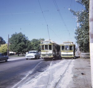
Photograph, Railway Crossing - Heatherdale Road, 2000
Produced as one of a series of 24 prints commissioned by Nunawading & District Historical Society -|Theme: Intersections of Mitcham and Nunawading 2000/2001.|See also Series by P. Simmenauer on the same theme.Black and white photograph - print and negative of Railway Crossing on Heatherdale Road near Heatherdale railway station looking north towards intersection of Whitehorse and Heatherdale Roads, from L - R Station signage 'The Met/Heatherdale Station (sign to be replaced by new owners Connex - see also No. 3 neg). Note Pedestrian & Cyclists signs; strip shops Hungry Jack's fast food; Dyns LPG Service Garage; ACE Auto Services; bus shelter.railway crossing, heatherdale road, mitcham, connex, 'the met', dyns, ace auto services, hungry jack's fast food outlet -
 Eltham District Historical Society Inc
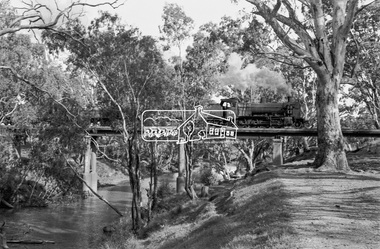
Photograph, Steam locomotive K-158 crossing the railway bridge over the Campaspe River at Rochester, Victoria, c.November 1963, 1963
It is the railway bridge over the Campaspe River at Rochester, Vic. original to the construction of the line. It was taken late on a Saturday morning and shows the regular goods train of that period approaching, then crossing the bridge. I originally planned to take just one view. The approaching train was first then it was a rapid run back along the raised river bank to get the broadside shot. I had little time to steady myself or properly check camera settings, hence the slightly soft focus etc. The train would eventually continue over the Echuca Iron Bridge into NSW. I think its ultimate destination was Deniliquin but not sure.Digital TIFF file Scan of 35mm Ilford FP3 black and white negative transparencygeorge coop collection, k-158, k-class steam locomotive (vr newport workshops), railway bridge, campaspe river, rochester -
 Eltham District Historical Society Inc
Photograph, Steam locomotive K-158 crossing the railway bridge over the Campaspe River at Rochester, Victoria, c.November 1963, 1963
It is the railway bridge over the Campaspe River at Rochester, Vic. original to the construction of the line. It was taken late on a Saturday morning and shows the regular goods train of that period approaching, then crossing the bridge. I originally planned to take just one view. The approaching train was first then it was a rapid run back along the raised river bank to get the broadside shot. I had little time to steady myself or properly check camera settings, hence the slightly soft focus etc. The train would eventually continue over the Echuca Iron Bridge into NSW. I think its ultimate destination was Deniliquin but not sure.Digital TIFF file Scan of 35mm Ilford FP3 black and white negative transparencygeorge coop collection, k-158, k-class steam locomotive (vr newport workshops), railway bridge, campaspe river, rochester -
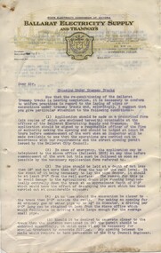 Ballarat Tramway Museum
Document - Letter/s, State Electricity Commission of Victoria (SECV), "Crossing Under Tramway Tracks", 1937
Yields information about the correspondence that was sent to various parties about the opening of tram tracks for underground services in Ballarat.Letter on SECV letterhead, "Ballarat Electricity Supply and Tramways", not dated, gives phone number, address, duplicated in blue ink, titled "Crossing Under Tramway Tracks", consisting of two foolscap sheets and one quarto sheet, pinned together in the top left hand corner. Would have been written as a base letter to go various bodies, has a Mr. Hornabrook's signature printed on it. Outlines the processes that have to be undertaken in order to install pipelines under tram tracks. Allows for Emergency installations, gives depths and installation requirements. The third sheet is an application form to install the service. See Reg Item 4946 for Bendigo, possibly used as a model for this document, given Reg Item 4943 correspondence.trams, tramways, letters, sec, tram track -
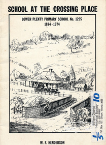 Eltham District Historical Society Inc
Book, School at the crossing place : Lower Plenty Primary School no. 1295, 1874-1974 / W.F. Henderson, 1974c
23 pages including information on inside covers. Text with black and white illustrations and photographs and map. Contents: Crossing Place Need for a school Residence for the teacher Closure A View of Lower Plenty 1918 Moving day at the Village The Golf Club Depression 1931 Vandals Electricity Grass Fires Cows at School Mothers' Club Women's liberation 1950's Lower Plenty after 1945 Swimming Pool - drowned dreams Long Grass - snakes - meadow hay - Fire Brigade The Royal Visit 1954 School Band Community Centre Our School Hall Trees and Gardens The Library Education 1874-1974 A Teacher's View The Second generation - children of ex-pupils (photo with names) The Third generation - Grandchildren of ex-pupils (photo with names) Head Teachers (list with dates) The Staff 1974 (photo with names) The sketch on the cover shows the Lower Plenty Bridge, toll house and the Plenty Bridge hotel, both no longer there. The bridge is listed in the Banyule Heritage Study and has recently been restored by Banyule Council as a pedestrian bridge - NL 137 March 2001 Paperback; [24] p. : ill. ; 25 cm.lower plenty, state school no. 1295, lower plenty primary school