Showing 259 items matching "cypress"
-
 Greensborough Historical Society
Newspaper clipping, Loyola College articles, 22/10/2010
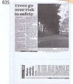
Article one (2000) is about the Loyola College Art Show; article two (1994) deals with an attempt by Diamond Valley Council to protect the former Loyola seminary building from demolition; article 3 (undated-Maybe 22/10/2010) deals with the removal of cypress trees on land at Loyola College. Articles were collected by Shirley Fraser (nee Black) whose family once owned and farmed the land on which Loyola stands. Mrs Fraser is mentioned in two of the articles.A collection of 3 articles about Loyola College, Watsonia. 2 originals, one photocopied.One article has "year 2000" written in pen.shirley fraser, shirley black, loyola college, loyola seminary watsonia -
 Lakes Entrance Historical Society
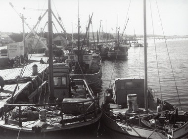
Photograph - Fishing Boats, 1955c
Black and white photograph of the eastern wharf, showing many fishing vessels moored at jetty, variously known as Harbecks Wharf and Scallop Wharf. Two sheds and fuel shed, motorbike, fishing nets and people on the jetty. Tops of War Memorial cypress trees, Cunninghame Arm Footbridge in background. Lakes Entrance Victoria fishing industry, waterfront, boats and boating, memorials -
 Lakes Entrance Historical Society
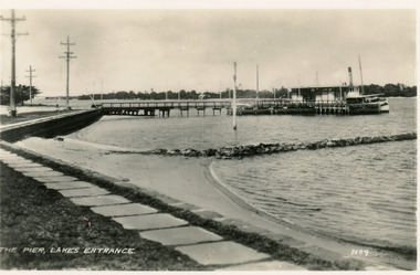
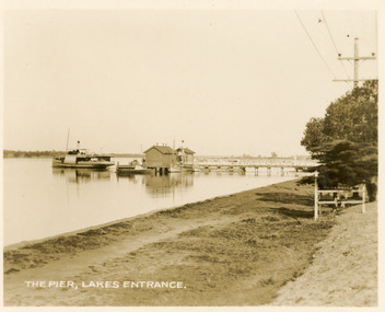
Postcard - Post Office Jetty, 1940c
Black and white small format postcard of the Post Office Jetty, showing a steamer at the end of the jetty, the passenger shelter, rock groyne from shore into lake, bluestone rock retaining wall and flagstone path at edge of lake, three electricity poles and one memorial cypress tree in distance. Lakes Entrance VictoriaThe Pier Lakes Entrancememorials, waterfront, ships and shipping -
 Lakes Entrance Historical Society
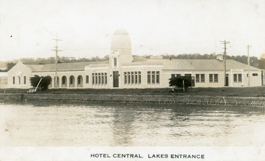
Postcard - Central Hotel Lakes Entrance, 1932c
Black and white postcard of Central Hotel, showing the brick Spanish style building constructed 1930-1931. Fronts the Esplanade and Cunninghame Arm. Postcard features memorial cypress trees planted 1924, bluestone wall along the lake front, white painted public bench, electricity poles. Lakes Entrance VictoriaHotel Central Lakes Entrancehotels, memorials, tourism, arts -
![Photograph - Digital image, Barn Site [Pope Place Greensborough], 02/05/2013](/media/collectors/4f729f5697f83e03086015b8/items/57286e072162f115acc6afe5/item-media/57286e402162f115acc6b473/item-fit-380x285.jpg) Greensborough Historical Society
Greensborough Historical SocietyPhotograph - Digital image, Barn Site [Pope Place Greensborough], 02/05/2013
This photograph of the site of the "Old Barn" (now Pope Place Greensborough) was taken in 2013 to show changes over 40 years, based on Ron Reynold’s sketches in the 1973 publication “Greensborough and Greenhills” published by Cypress Books. The old barn was built at the turn of the century (1900) and demolished in the early 1970s. A retirement village is now on this site.Digital copy of colour photograph.greensborough and greenhills, pope place greensborough, ron reynolds -
 University of Melbourne, Burnley Campus Archives
Photograph - Colour prints, Denise Johnstone, Burnley College & Yarraville Gardens, 1999
1-11. Colour photographs of Trees in Yarraville Gardens. 12. Bunya Bunya Pine in Luffmann lawn. 13. Italian Cypress near Sunken Garden. 14. Crack Willow beside Luffmann Ponds. Cork Oak in Bull Paddock. 16. Araucaria cunninghammii in Bull Paddock. 17-20. Demonstrating tree climbing.trees, yarraville gardens, bunya bunya pine, luffmann lawn, italian cypress, sunken garden, crack willow, luffmann ponds, cork oak, bull paddock, araucaria, tree climbing -
![Photograph - Digital image, Civic Centre [Greensborough], 02/05/2013](/media/collectors/4f729f5697f83e03086015b8/items/5729b7242162f108e8de0add/item-media/5729b7552162f108e8de1585/item-fit-380x285.jpg) Greensborough Historical Society
Greensborough Historical SocietyPhotograph - Digital image, Civic Centre [Greensborough], 02/05/2013
These three photographs of the Civic Centre precinct, including the Diamond Valley Library; were taken in 2013 to show changes over 40 years; based on Ron Reynold’s sketches in the 1973 publication 'Greensborough and Greenhills' published by Cypress Books. Built in the 1970s, the Civic Centre was originally the offices of the Shire of Diamond Valley but is now the offices of the Shire of Nillumbik.Digital copy of 3 colour photographs.greensborough and greenhills, shire of diamond valley, shire of nillumbik, ron reynolds -
 Lakes Entrance Historical Society
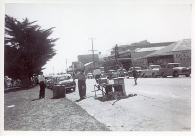
Photograph, 1950c
Black and white photograph of a section of Esplanade. In view are the Maranui Motel, Catalina Cafe, Bulmers Gift Shop, Bill's hairdresser. Cypress trees on grassy verge on south side of highway. 44 gallon drum, trestle table and frame for shelter on edge of road seemingly in preparation for, or remaining after a street celebration. Lakes Entrance Victoriamemorials, township, celebrations, retail trade -
 Lakes Entrance Historical Society
Postcard - Western Wharf, Valentine Series, 1930c
Also sepia copy 10x15cm, black and white copies 10x17cm, and 14x24cmSepia coloured small format postcard of the Western wharf, Lakes Entrance, Victoria. It shows the pier variously called the Post Office Jetty, Freemans Jetty, as the steamer leaves. Smaller vessels moored beside jetty. Shoreline edged with bluestone, wooden tree guard surrounding young memorial cypress tree. Lakes Entrance VictoriaThe Pier Lakes Entrancememorials, jetties, waterfront, ships and shipping -
 Glenelg Shire Council Cultural Collection
Postcard - Postcard - Portland Beach, 1905-1915
Black and white postcard. Showing band reserve and beach at Portland. Looking towards sea. railway pier and ocean pier visible, in background. Two ladies sitting on bench, right 3 men lying in grass, right. Cypress in tree guard, beach shelter, numerous people sitting/walking on beach. Reverse, address and message in pen, penny stamp.Front: 'Band Reserve and Beach, Portland'- printed bottom left. Back- Message and address in pen.photography, postcard, portland seafront, beach, recreation -
 University of Melbourne, Burnley Campus Archives
Album - 35mm Colour slides, D. Johnstone, Diseases, 2000
27 slides labelled "Diseases". Some individually labelled. Some also labelled "D. Johnstone". 8 June 2000. 1-4. appear to be part of B20.0157. 6-12 Cypress Canker. 13. Teprioadium. 14. "Paint" fungus. 15. Tremetes versicolour. 16. Armillaria (old). 17-18. Laetiporus portentotus. 20. Poplar 95 formes. d. johnstone, arboriculture, tree diseases, cypress canker, teprioadium, tremetes versicolour, armillaria, poplar 95 formes, laetiporus potentotus -
 Buninyong & District Historical Society
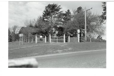
Photograph - Original B/W Photograph, Clive Brooks, Buninyong Botanic Gardens, main gate, Cnr. Scott and Inglis Streets
B/W photo, across intersection to gates on corner of Scott and Inglis Streets, double iron gates with single gates either side, then short length of picket fence. Wire fence down Scott Street to left, wire fence and hedge along Inglis to left. Big Cypress tree centre behind gate, assorted other large trees surrounding.buninyong, botanic gardens, gate, streetscape, trees -
 Lakes Entrance Historical Society
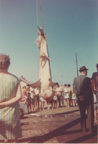
Photograph - Australian Anglers Association Carnival and Convention Lakes Entrance c1955
04308.1, 12 x 13 cmColour photograph of campers from Carpenters Camp Park viewing a large shark caught at sea and hanging on the Eastern Wharf Lakes Entrance Victoria c1965. Also a black and white photograph of the Australian Anglers Association Carnival and Convention marquee set up on Esplanade shows two memorial cypresses a number of cars parked and onlookers near marquee taken 1955 cevents, fishing, caravan parks, gippsland lakes -
 Southern Sherbrooke Historical Society Inc.
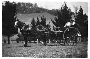
Photograph - Cissie Johns in jinker, c.1913
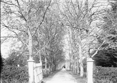
B&W photo shows Cissie Johns and another person who may be her brother Percy, sitting in a jinker. A dark horse with a white blaze is harnessed to the jinker. Cissie is seated nearest the camera. She is wearing a pale wide-brimmed hat and pale clothing. Her long fair hair is loose around her shoulders. The other person is holding the reins and is wearing a dark hat and pale shirt. This photo may have been taken at the same time as M0104. The subjects are facing south. The sun is shining. They are on a flat expanse of grass. Beyond them are several cypress trees. These are most likely part of the cypress hedges lining the driveway to Glen Park Farm farmhouse. In the background is the eastern flank of Black Hill. A small shed can be seen beside the driveway, partly obscured by the jinker's wheel. Dated c.1913. -
Glenelg Shire Council Cultural Collection
Photograph - Sheet of 2 black and white contact prints from glass plate negatives, 1960-1970
Sheet of 2 black and white contact prints from glass plate negatives. Measurements are 11.8 x 16.1 cm for both prints. Top: Image of stone house with shingle roof and stone chimneys. Veranda with iron support poles and lacework. Vines growing up poles. (same house as 5622) Front view. Bottom: Man on horse. Cypress pines, wooden fence behind. -
 Whitehorse Historical Society Inc.
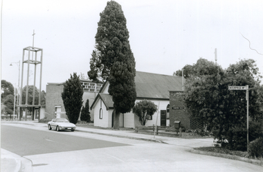
Photograph, Corner Enterprise Way & Edward Street, Mitcham, 2000
Produced as one of a series of 24 prints commissioned by Nunawading & District Historical Society -|Theme: Intersections of Mitcham and Nunawading 2000/2001.|See also Series by P. Simmenauer on the same theme.Black and white photograph - print and negative of corner of Enterprise Way & Edward Street looking South towards Whitehorse Road, Mitcham. L-R: Church Tower [Anglican Church](built circa 1959). Tower surmounts a modern church building in brick and concrete; next door Church Hall 1888 weatherboard construction; Cypress tree; Forster Hall, brick building (circa 1975)forster hall, mitcham, christ church anglican church, church hall -
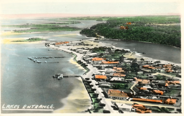 Lakes Entrance Historical Society
Photograph - Lakes Entrance, 1945c
Two tinted copies, one 8.5 x 13.5 and one 6.5 x 9Black and white postcard showing town, twelve memorial cypress trees and spotting tower on foreshore, post office wharf, boat harbour, Club Hotel at west end of esplanade with five palm trees opposite, causeway to Bullock Island, highway bridge over North Arm, highway up to Jemmys Point, Rigby, Fraser and Flannagan Island's towards Metung. Lakes Entrance VictoriaLakes Entrance islands, aerial photograph, waterways, township -
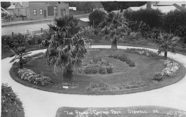 Stawell Historical Society Inc
Photograph, Central Park Gardens --- 2 Photos 1920's, c1910 - 1920
Central Park Gardens. T R G Williams of Ararat Postcard No36. View from Grandstand with Palms and C.E. General, store in Main Street in Background. Additional later similar photograph with two men near palm tree. John Straton's Wool Skin Store, Commission Agent, in background, later purchased by N. Godfrey who came from Rupanyup but lived in St. George St. Stawell. Photo from Ivan Hodder in 1988. Note Picket fence. Black & white Post card by photographer T.R.G. Williams Ararat of The Palms Central Park Stawell 36. Note Cypress hedge removed with view of general store across Lower Main St. c1910-1920 Second photograph taken from the same position c1920 - 1930 with 2 gentleman in lower left of photograph. John Straton's wool & skin store visible in background.Photograph by T.R.G. Williams Ararat stawell, streetscape -
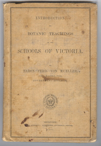 Federation University Historical Collection
Book, Ferdinand von Mueller, Introduction to Botanic Teachings at the Schools of Victoria, 1877, 1877 (exact)
Ferdinand von Mueller was an examiner of botany at the Ballarat School of Mines (SMB) between 1880 and 1888. During that era he was active in donating related items to the School. When the Ballarat School of Mines Council agreed to introduce pharmacy and botany classes in 1879, it was apparent students would require access to botanical specimens in order to further their studies. Council members, who were inspired by the work of Baron Ferdinand von Mueller, authorised development of an area along the School's northern boundary, fronting Lydiard Street South, and oversaw the establishment of the new Botanical Gardens. Baron von Mueller took a practical role the development of SMB's Botanical Gardens from the beginning. He became a generous benefactor who 'donated collections of seeds and leguminous fodder plants, including valued grasses of interest and use to agriculturalists and graziers generally' to SMB over many years. Ferdinand von Mueller's entry on the University of Ballarat Honour Roll can be found at http://www.ballarat.edu.au/curator/honour-roll/honourroll_von_mueller.shtml A light brown, hardcovered book of 152 pages. Chapters include Eucalyptus Trees; Wattles or Acacias; Casuarinas or Sheoaks; Cypress Pines or Sandarac trees; Exocarpos trees of Natice Cherry trees; Mistletoes; Native Honeysuckles or Banksias; Bellflower, Lobelia and Goodenia; Heaths; Correas; Mallow; Buttercups and Clematis; Cruciferous Plants; Mints; Orchids; grasses; ferns. The book has numerous botanical line drawings, and a comprehensive index.Inside front cover "J. Clement Souter M.D."victorian, schools, botany, ferdinand von mueller, von mueller, botanic illustrations, j. clement souter -
 Ringwood and District Historical Society
Photograph, Mrs Lydia Mary Honeyman's home at 82 Ringwood St Ringwood being demolished in June 1970
Mrs Lydia Mary Honeyman's home at 82 Ringwood St Ringwood being demolished, including the enormous Cypress hedge that fronted the road in June 1970.The photos were taken from our property 85 Ringwood St, directly across from the Honeyman property. (The properties were all renumbered when the new police station opened in Ringwood St and we became #97). (Pam Payne) -
 Stawell Historical Society Inc
Photograph, “The Sycamores” Driveway entrance Gates
Entrance gates to “The Sycamores” Driveway. A show place on Concongella from mid 1860's. "The Sychmores" where William Osmand lived. Osmand's "Sycamores" was in a secluded block of the eastern side of the creek along which was planted pine and cypress trees. He built a comfortable house and line the carriage way with Sycamores. Osmand was on the of the men who made money in the Stawell reefs mines. "The Sycamores" has been owned by the West family since c 1920. Black & white photograph (2 copies) of an entrance gateway with an avenue of deciduous trees.concongella -
 Phillip Island and District Historical Society Inc.
Photographs, 1978-9
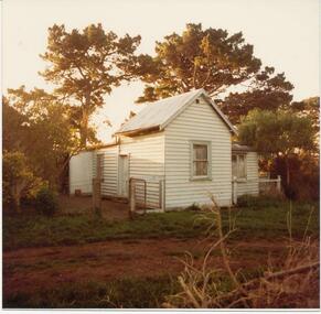
House built by Mr Joseph Richardson about 1870 at Ventnor on the corner of what is now The Nobbies and Graydens Road. Lived in by several well known families.Four Photographs of a Timber house with corrugated iron roof. 81-84 Rain water tank. Note wooden door. Fence surround and gate. 81-84a Possibly back view of the house with verandah on end. 81-84b Bullnose verandah, brick chimney. Note roof and cypress trees in background and ?wattle bushes in foreground. 81-84c Looks as though a sleepout or bathroom was added on end of verandah. rubbish in foreground.local history, photographs, buildings - historic, coloured photograph, john cook, phillip island, richardson -
 Bendigo Historical Society Inc.
Photograph - BOTANICAL GARDENS
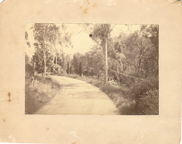
sepia photograph on cream board. Driveway/pathway, gravelled, eucalypt and conifer trees, uncut grass, wire fence middle distance. Pathway curving to left from front of photo. Written in blue pen on rear of photo : Botanical Gardens or early path in Fortuna. English trees planted, e.g. cypress. Holdsworth Road, adj. White Hills Cemetery Reserve. Crowned road grade. Heavy intermediate fence posts.unknownplace, land, botanical gardens, fortuna ? -
 Surrey Hills Historical Society Collection
Photograph, 215 Union Road, c 1920
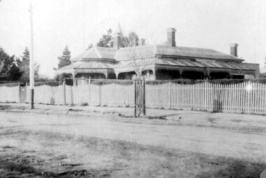
The house was variously known as ‘Mintaro’, ‘Montiere’ and ‘Goonoo Goonoo’, the later after 1920 when it was purchased by Natale Cerini and his wife Ethel May (nee Swan), who were married in 1918. Built 1887-1888 by William Wigley. The original colour was deep cream with dark green trim. Property included a block of land on south side and also land to the north. The original coach house was on what became 213 Union Road and was used to build a yacht in by the then neighbours, the Flemings. The street plane trees were replaced in the 1970s with melaleucas and in 1987 new plane trees were planted between the melaleucas. Sepia copy of an older photo of 215 Union Road from diagonally across the road. Shows street surface, bluestone kerbing, a young tree within a guard and a Victorian style home with 3 chimneys, a slate roof and a veranda on at least the south and west side. Beyond the house are mature cypress and other trees and a spire. The spire belonged to Surrey College, a boys' boarding school (later Nethercourt Hospital and St Judes.)'mintaro', 'montiere', 'goonoo goonoo', william wigley, mrs ethel may cerini, miss ethel may swan, miss jocelyn cerini, mrs jocelyn hall, miss lynette cerini, victorian style, 215 union road -
 Lakes Entrance Historical Society
Postcard - Esplanade Lakes Entrance, 1945c
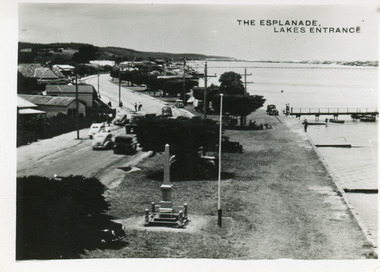
Original from wallet of miniature postcards produced by Bulmer, two copies. 01419.1 and .2 Also two enlargements 17 x 25 cmBlack and white small format postcard of Esplanade, taken from the WW2 Air Observers Spotting Tower. In the foreground is the Cenotaph erected 1922 on the grass verge between road and lake. Trimmed WW1 Cypress trees also on verge. Cars and truck on highway all travelling in easterly direction. Houses and businesses on north side of road, Princes Highway, which follows the margin of the lake shore. Lakes Entrance VictoriaThe Esplanade Lakes Entrancetownship, waterfront, transport, world war 1939 - 1945, world war 1914-1918 -
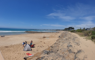
 Ballarat Heritage Services
Photograph, Clare Gervasoni, Apollo Bay, Victoria, 24/01/2022
In 2021, the Department of Environment, Land, Water and Planning (DELWP) constructed two new groynes and a section of rock seawall at Apollo Bay to help manage the impacts of coastal erosion. The new 70-meter-long rock groynes run perpendicular to the shoreline and be located just south of the Milford St revetment and to the south of Milford Creek. Sections of rock seawall will be constructed between the two Groynes with an aim to protect the dune, walking path, cypress trees and road from erosion. Colour photograph of a coastal scene at Apollo Bay, featuring new rock groynes to protect the Great Ocean Road from erosion. apollo bay, beach, coast, groyne, rockwall -
 Ballarat Heritage Services
Photograph, Clare Gervasoni, Apollo Bay, Victoria, 24/01/2022
In 2021, the Department of Environment, Land, Water and Planning (DELWP) constructed two new groynes and a section of rock seawall at Apollo Bay to help manage the impacts of coastal erosion. The new 70-meter-long rock groynes run perpendicular to the shoreline and be located just south of the Milford St revetment and to the south of Milford Creek. Sections of rock seawall will be constructed between the two Groynes with an aim to protect the dune, walking path, cypress trees and road from erosion. Colour photograph of a coastal scene at Apollo Bay, featuring new rock wall and groynes to protect the Great Ocean Road from erosion. apollo bay, beach, coast, groyne, rockwall -
 Ballarat Heritage Services
Photograph, Clare Gervasoni, Sea Wall at Apollo Bay, Victoria, 24/01/2022
In 2021, the Department of Environment, Land, Water and Planning (DELWP) constructed two new groynes and a section of rock seawall at Apollo Bay to help manage the impacts of coastal erosion. The new 70-meter-long rock groynes run perpendicular to the shoreline and be located just south of the Milford St revetment and to the south of Milford Creek. Sections of rock seawall will be constructed between the two Groynes with an aim to protect the dune, walking path, cypress trees and road from erosion. Colour photograph of a coastal scene at Apollo Bay, featuring new rock wall and groynes to protect the Great Ocean Road from erosion. apollo bay, beach, coast, groyne, rockwall, sea wall -
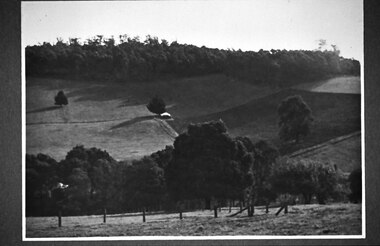 Southern Sherbrooke Historical Society Inc.
Photograph - Glen Park Farm, Selby
B&W photo showing Glen Park Farm, Selby, owned by the Johns family, as seen from the north-east corner. Photo shows the descent to the valley then up Black Hill in the background. Mostly cleared paddock apart from the cypress avenue to the farmhouse (which is glimpsed between the trees) a few single trees dotted about, and the heavily treed area on the top of Black Hill. There is a small building or shed or possibly a haystack in the centre of the photo.